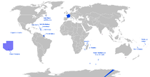
عصر الاستكشاف
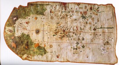
Naval Museum of Madrid, Madrid, Spain.
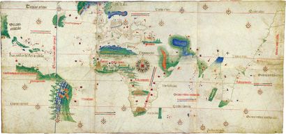
Biblioteca Estense, Modena, Italy.
عصر الاستكشاف هو الفترة من أوائل القرن الخامس عشر والمستمرة حتى أوائل القرن السابع عشر، قامت السفن الأوروبية خلالها بالسفر حول العالم للبحث عن طرق تجارية جديدة وعن شركاء تجارة جدد لتغذية الرأسمالية السريعة النمو في أوروبا. وأثناء بحثهم عثروا صدفة على أراضٍ كانت مجهولة بالنسبة إليهم. من أشهر المستكشفين في ذلك الوقت: كرستوفر كولومبوس، ڤاسكو دا گاما، وفرديناند ماجلان.
شكل التقدم التقني والفكري في عصر النهضة البذرة التي بدأت عصر الاستكشاف. وقد شمل هذا التقدم علوما مختلفة كعلم الخرائط والملاحة والتطورات في بناء السفن والتي كان أهمها اختراع السفن الكبيرة والتي جمعت التصميم العربي والأوروبي للسفن مما جعل الإبحار خارج البحر المتوسط آمنا. يضاف إلى ذلك رغبة العديد في أوروبا لإيجاد طريق بديل للذهاب إلى آسيا عن طريق الغرب.
عرض عام
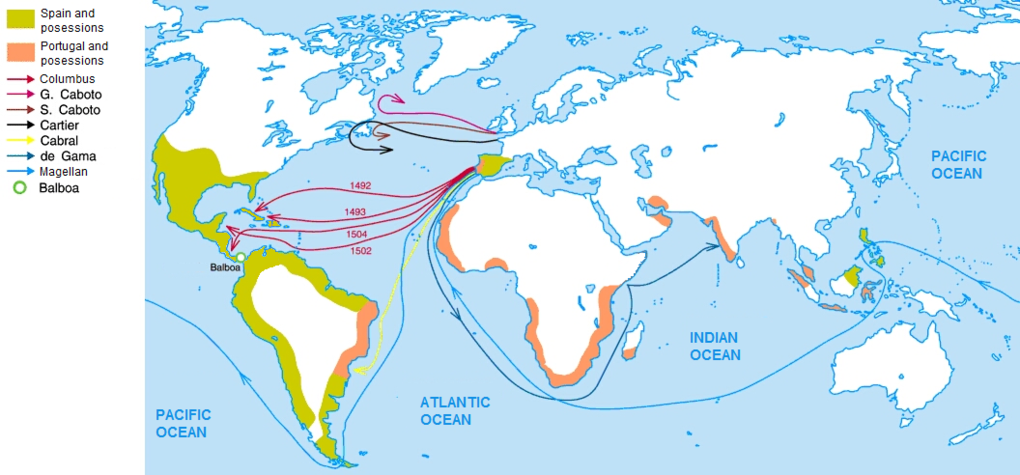
| Major discovery/ Destination | Main explorer | السنة | Funding by |
|---|---|---|---|
| Congo River | Diogo Cão | 1482 | John II of Portugal |
| Cape of Good Hope Indian Ocean | Dias | 1488 | John II of Portugal |
| West Indies | Columbus | 1492 | Ferdinand and Isabella |
| India | Vasco da Gama | 1498 | Manuel I |
| Brazil | Cabral | 1500 | Manuel I |
| Spice Islands Australasia (Western Pacific Ocean) | Albuquerque, Abreu and Serrão | 1512 | Manuel I |
| Pacific Ocean | Vasco Balboa | 1513 | Ferdinand II of Aragon |
| Strait of Magellan | Magellan | 1520 | Charles I of Spain |
| Circumnavigation | Magellan and Elcano | 1522 | Charles I of Spain |
| Australia | Willem Janszoon | 1606 | United East India Company |
| New Zealand | Abel Tasman | 1642 | United East India Company |
| Antarctica | James Cook | 1773 | George III |
| Hawaii | James Cook | 1778 | George III |
التكنولوجيا: تصميم السفن والبوصلة

Technological advancements that were important to the Age of Exploration were the adoption of the magnetic compass and advances in ship design.
الجغرافيا والخرائط
The Periplus of the Erythraean Sea, a document dating from 40–60 AD, describes a newly discovered route through the Red Sea to India, with descriptions of the markets in towns around Red Sea, Persian Gulf and the Indian Ocean, including along the eastern coast of Africa, which states "for beyond these places the unexplored ocean curves around toward the west, and running along by the regions to the south of Aethiopia and Libya and Africa, it mingles with the western sea (possible reference to the Atlantic Ocean)". European medieval knowledge about Asia beyond the reach of the Byzantine Empire was sourced in partial reports, often obscured by legends,[1] dating back from the time of the conquests of Alexander the Great and his successors.
Another source was the Radhanite Jewish trade networks of merchants established as go-betweens between Europe and the Muslim world during the time of the Crusader states.
In 1154, the Arab geographer Muhammad al-Idrisi created a description of the world and a world map, the Tabula Rogeriana, at the court of King Roger II of Sicily,[2][3] but still Africa was only partially known to either Christians, Genoese and Venetians, or the Arab seamen, and its southern extent unknown. There were reports of great African Sahara, but the factual knowledge was limited for the Europeans to the Mediterranean coasts and little else since the Arab blockade of North Africa precluded exploration inland. Knowledge about the Atlantic African coast was fragmented and derived mainly from old Greek and Roman maps based on Carthaginian knowledge, including the time of Roman exploration of Mauritania. The Red Sea was barely known and only trade links with the Maritime republics, the Republic of Venice especially, fostered collection of accurate maritime knowledge.[4]
السفر في القرون الوسطى (1241–1438)


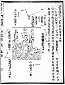
البعثات الصينية (1405–1433)
المحيط الأطلسي (1419–1507)
الاستكشاف حسب البلد
مهد لعصر الاستكشاف سلسلة من الحملات الأوروبية التي تعدت أراضي أوراسيا عن طريق البر في أواخر العصور الوسطى. فبينما شكل المغول خطرا يهدد أوروبا بالنهب والدمار، فقد أدت هذه الظروف إلى توحد أغلب آسيا وأوروبا في إنشاء طرق تجارية وخطوط تواصل امتدت من الشرق الأوسط وحتى الصين. وقد استغل بعض الأوروبين الفرصة للسفر والاستكشاف شرقا، وكان غالبيتهم العظمى من الإيطاليين نظرا لكونهم طرق التجارة بين أوروبا والشرق الأوسط خاضعة تحت سيطرة التجارة من المدن الإيطالية. وقد كان قرب هؤلاء من ما يعرف اليوم ببلاد الشام الدور الكبير في خلق الفضول والاهتمام التجاري لما يكمن خلف هذه الحدود. وكذلك، فقد أطلق البابا حملات لأهداف دينية.
نهاية عصر الاستكشاف
يقال بأن عصر الاستكشاف انتهى في بداية القرن السابع عشر، في الوقت الذي كان باستطاع السفن الأوروبية أن تبحر لأي مكان في الكوكب. ولكن الاستكشاف لم ينتهِ، فلم يتم اكتشاف المحيط المتجمد الشمالي والجنوبي إلا فالقرن التاسع عشر.
الوقع العالمي
الوقع الاقتصادي على أوروپا

|
المواضيع
|
|
العمارة |
المناطق
|
|
إنگلترة |


انظر أيضاً
- عصر الشراع
- Atlantic slave trade
- Catholic Church and the Age of Discovery
- Chinese maritime exploration
- Chronology of European exploration of Asia
- Columbian Exchange
- Exploration
- European exploration of Australia
- History of navigation
- L'Anse aux Meadows
- List of explorations
- Major explorations after the Age of Discovery
- Maritime history
- Portuguese inventions
- Pre-Columbian trans-oceanic contact
- Scramble for Africa
- Timeline of European exploration
- Winds in the Age of Sail
المراجع
- ^ Arnold 2002, p. xi.
- ^ Houben, 2002, pp. 102–04.
- ^ Harley & Woodward, 1992, pp. 156–61.
- ^ Abu-Lughod 1991, p. 121.
ببليوگرافيا
المصادر الرئيسية
- Castillo, Bernal Díaz del, John Michael Cohen (1963) [1632]. The conquest of New Spain. Penguin Classics. ISBN 978-0-14-044123-9. Retrieved 2011-06-16.
{{cite book}}: CS1 maint: multiple names: authors list (link) - Galvano, Antonio (2004-03-01) [1563year=2004]. The Discoveries of the World from Their First Original Unto the Year of Our Lord 1555, issued by the Hakluyt Society. Kessinger Publishing. ISBN 978-0-7661-9022-1. Retrieved 2011-06-16.
- Linschoten, Jan Huyghen van (2004) [1598]. Voyage to Goa and Back, 1583–1592, with His Account of the East Indies: From Linschoten's Discourse of Voyages, in 1598. New Delhi, AES. ISBN 978-81-206-1928-9.
- Pires, Tomé, Armando Cortesão, Francisco Rodrigues (1990) [1512]. The Suma oriental of Tome Pires: an account of the East, from the Red Sea to China, written in Malacca and India in 1512–1515; and, The book of Francisco Rodrigues: Pilot-Major of the armada that discovered Banda and the Moluccas. Asian Educational Services. ISBN 978-81-206-0535-0. Retrieved 2011-06-16.
{{cite book}}: CS1 maint: multiple names: authors list (link) - Mancall, Peter C. (2006). Travel narratives from the age of discovery: an anthology. Oxford University Press US. ISBN 978-0-19-515597-6. Retrieved 2011-06-16.
- "Real Cédula aprobando la capitulación concedida por Carlos V a Francisco Pizarro para la conquista y población del Perú" (in الإسبانية). Biblioteca Virtual Miguel de Cervantes. Retrieved 17 June 2010.
الكتب
- Abu-Lughod, Janet (1991). Before European Hegemony: the world system a.d. 1250–1350. Oxford University Press US. ISBN 978-0-19-506774-3. Retrieved 2011-06-16.
- Anderson, James Maxwell (2000). The history of Portugal. Greenwood Publishing Group. ISBN 978-0-313-31106-2. Retrieved 2011-06-16.
- Arciniegas, Germán (1978). Amerigo and the New World: The Life & Times of Amerigo Vespucci. Octagon Books. ISBN 978-0-374-90280-3.
- Armesto, Felipe Fernandez (2006). Pathfinders: A Global History of Exploration. W.W. Norton & Company. ISBN 978-0-393-06259-5.
- Arnold, David (2002). The Age of Discovery, 1400–1600, Lancaster pamphlets. Routledge. ISBN 978-0-415-27996-3. Retrieved 2011-06-16.
- Boxer, Charles Ralph (1969). The Portuguese Seaborne Empire 1415–1825. Hutchinson. ISBN 978-0-09-131071-4. Retrieved 2011-06-16.
- Boxer, Charles Ralph (1977). The Dutch seaborne empire, 1600–1800. Taylor & Francis. ISBN 978-0-09-131051-6. Retrieved 2011-06-16.
- Braudel, Fernand (1992) [1979]. The Wheels of Commerce, vol. II of Civilization and Capitalism 15th–18th Century. University of California Press. ISBN 978-0-520-08115-4. Retrieved 2011-06-16.
- Braudel, Fernand (1992) [1985]. The perspective of the world. University of California Press. ISBN 978-0-520-08116-1. Retrieved 2011-06-16.
- Brook, Timothy (1998). The Confusions of Pleasure: Commerce and Culture in Ming China. University of California Press. ISBN 978-0-520-22154-3. Retrieved 2011-06-16.
- Burns, William E. (2001). The scientific revolution: an encyclopædia. ABC-CLIO. ISBN 978-0-87436-875-8. Retrieved 2011-06-16.
- Butel, Paul (1999). The Atlantic. Routledge. ISBN 978-0-415-10690-0. Retrieved 2011-06-16.
- Cole, Juan Ricardo (2002). Sacred Space and Holy War. I.B.Tauris. ISBN 978-1-86064-736-9. Retrieved 2011-06-16.
- Cook, Noble David (1998). Born to die: disease and New World conquest, 1492–1650. Cambridge University Press. ISBN 978-0-521-62730-6. Retrieved 2011-06-16.
- Crosby, Alfred W., Jr (2003) [1972]. The Columbian Exchange: Biological and Cultural Consequences of 1492 (30th Anniversary ed.). Greenwood Publishing Group. ISBN 978-0-275-98092-4. Retrieved 2011-06-16.
{{cite book}}: CS1 maint: multiple names: authors list (link) - Cromer, Alan (1995). Uncommon Sense: The Heretical Nature of Science. Oxford University Press US. ISBN 978-0-19-509636-1. Retrieved 2011-06-16.
- Crow, John A. (1992). The Epic of Latin America. University of California Press. ISBN 978-0-520-07723-2. Retrieved 2011-06-16.
- Daus, Ronald (1983). Die Erfindung des Kolonialismus. Wuppertal/Germany: Peter Hammer Verlag. ISBN 978-3-87294-202-9.
- Davenport, Frances Gardiner (1917). European Treaties Bearing on the History of the United States and Its Dependencies to 1648. Washington, DC: Carnegie Institute of Washington. Retrieved 2011-06-16.
- De Lamar, Jensen (1992). Renaissance Europe: age of recovery and reconciliation. D.C. Heath. ISBN 978-0-669-20007-2.
- Diffie, Bailey (1977). Foundations of the Portuguese Empire, 1415–1580. University of Minnesota Press. ISBN 978-0-8166-0782-2. Retrieved 2011-06-16.
- Diffie, Bailey (1960). Prelude to empire: Portugal overseas before Henry the Navigator. University of Nebraska Press. ISBN 978-0-8032-5049-9. Retrieved 2011-06-16.
- Dymytryshyn, Basil, E.A.P. Crownhart-Vaughan, Thomas Vaughan (1985). Russia's conquest of Siberia, 1558–1700: a documentary record (in Russian). Western Imprints, The Press of the Oregon Historical Society. ISBN 978-0-8032-5049-9. Retrieved 2016-02-10.
{{cite book}}: CS1 maint: multiple names: authors list (link) CS1 maint: unrecognized language (link) - Donkin, R.A. (2003). Between east and west: the Moluccas and the traffic in spices up to the arrival of Europeans. Memoirs of the American Philosophical Society, Diane Publishing. ISBN 978-0-87169-248-1. Retrieved 2011-06-16.
- Dunn, Ross E. (2004). The adventures of Ibn Battuta, a Muslim traveler of the fourteenth century. University of California Press. ISBN 978-0-520-24385-9. Retrieved 2011-06-16.
- Dunton, Larkin (1896). The World and Its People. Silver, Burdett.
- Ebrey, Patricia Buckley, Anne Walthall, James B. Palais (2006–2008). East Asia: A Cultural, Social, and Political History. Houghton Mifflin. ISBN 978-0-618-13384-0. Retrieved 2011-06-16.
{{cite book}}: CS1 maint: multiple names: authors list (link) - Fisher, Raymond H. (1981). The Voyage of Semen Dezhnev in 1648. The Hakluyt Society. ISBN 978-0-904180-07-7.
- Fiske, John (1892–2009). The Discovery of America: With Some Account of Ancient America and the Spanish Conquest. Houghton Mifflin. ISBN 978-1-110-32015-8. Retrieved 2011-06-16.
- Forbes, Jack D. (1993). Africans and Native Americans: the language of race and the evolution of Red-Black peoples. University of Illinois Press. ISBN 978-0-252-06321-3. Retrieved 2011-06-16.
- Gernet, Jacques (1962). Daily life in China, on the eve of the Mongol invasion, 1250–1276. Stanford University Press. ISBN 978-0-8047-0720-6. Retrieved 2011-06-16.
- Gitzen, Garry (2011). Francis Drake in Nehalem Bay 1579, Setting the Historical Record Straight. Fort Nehalem. Retrieved 2011-06-16.
- Goodrich, Luther Carrington, Chao-ying Fang, Ming Biographical History Project Committee – Association for Asian Studies. (1976). Dictionary of Ming biography, 1368–1644. Columbia University Press. ISBN 978-0-231-03833-1.
{{cite book}}: CS1 maint: multiple names: authors list (link) - Gutierrez, Ramon A, and Richard J. Orsi (1998). Contested Eden: California before the Gold Rush. University of California Press. ISBN 978-0-520-21274-9. Retrieved 2011-06-16.
{{cite book}}: CS1 maint: multiple names: authors list (link) - Hacquebord, Louwrens (September 1995). "In Search of Het Behouden Huys: A Survey of the Remains of the House of Willem Barentsz on Novaya Zemlya" (PDF). Arctic. 48 (3): 250. CiteSeerX 10.1.1.505.5702. doi:10.14430/arctic1246. Archived from the original (PDF) on 27 March 2009. Retrieved 2009-03-08.
{{cite journal}}: Unknown parameter|deadurl=ignored (|url-status=suggested) (help) - Hochstrasser, Julie (2007). Still life and trade in the Dutch golden age. Yale University Press. ISBN 978-0-300-10038-9.
- Howard, David and John Ayers (1978). China for the West: Chinese Porcelain and other Decorative Arts for Export, Illustrated from the Mottahedeh Collection. London and New York: Sotheby Parke Bernet.
- Lach, Donald F., Edwin J. Van Kley (1998). Asia in the Making of Europe, Volume III: A Century of Advance. Book 3: Southeast Asia. University of Chicago Press. ISBN 978-0-226-46768-9. Retrieved 2011-06-16.
{{cite book}}: CS1 maint: multiple names: authors list (link) - Lawson, Edward W. (2007). The Discovery of Florida and Its Discoverer Juan Ponce de Leon. Kessinger Publishing. ISBN 978-1-4325-6124-6.
- Lincoln, W. Bruce (2007) [1994]. The Conquest of a Continent: Siberia and the Russians. Cornell University Press. ISBN 978-0-8014-8922-8. Retrieved 2011-06-16.
- Locke, John (1824). The works of John Locke: in nine volumes, Volume 9" The history of navigation. C. and J. Rivington. Retrieved 2011-06-16.
- Mancall, Peter C. (1999). "The Age of Discovery" in The Challenge of American History, ed. Louis Masur. Johns Hopkins University Press. ISBN 978-0-8018-6222-9. Retrieved 2011-06-16.
- Medina (1974) [1918]. El Piloto Juan Fernandez descubridor de las islas que ilevan su hombre, y Juan Jufre, armador de la expedicion que hizo en busca de otras en el mar del zur (in الإسبانية). Gabriela Mistral. ISBN 978-0-313-32043-9.
- Milton, Giles (1999). Nathaniel's Nutmeg. London: Sceptre. ISBN 978-0-340-69676-7.
- Morison, Samuel Eliot (2007) [1942]. Admiral of the Ocean Sea: The Life of Christopher Columbus. Read Books. ISBN 978-1-4067-5027-0. Retrieved 2011-06-16.
- Mutch, T.D. (1942). The First Discovery of Australia. Sydney: Journal of the Royal Australian Historical Society. Archived from the original on 29 June 2011. Retrieved 2011-06-16.
{{cite book}}: Unknown parameter|deadurl=ignored (|url-status=suggested) (help) - Newitt, Malyn D.D. (2005). A History of Portuguese Overseas Expansion, 1400–1668. Routledge. ISBN 978-0-415-23979-0. Retrieved 2011-06-16.
- Nowell, Charles E. (1947). The Discovery of the Pacific: A Suggested Change of Approach. The Pacific Historical Review (Volume XVI, Number 1).
{{cite book}}: Italic or bold markup not allowed in:|publisher=(help) - Otfinoski, Steven (2004). Vasco Nuñez de Balboa: explorer of the Pacific. Marshall Cavendish. ISBN 978-0-7614-1609-8. Retrieved 2011-06-16.
- Pacey, Arnold (1991). Technology in world civilization: a thousand-year history. MIT Press. ISBN 978-0-262-66072-3. Retrieved 2011-06-16.
- Paine, Lincoln P. (2000). Ships of discovery and exploration. Houghton Mifflin Harcourt. ISBN 978-0-395-98415-4. Retrieved 2011-06-16.
- Parry, J.H. (1981). The age of reconnaissance. University of California Press. ISBN 978-0-520-04235-3. Retrieved 2011-06-16.
- Parry, J.H. (1981). The Discovery of the Sea. University of California Press. ISBN 978-0-520-04237-7. Retrieved 2011-06-16.
- Penrose, Boies (1955). Travel and Discovery in the Renaissance:1420–1620. Harvard University Press. ISBN 978-0-689-70153-5.
- Pfoundes, C. (1882). Notes on the History of Eastern Adventure, Exploration, and Discovery, and Foreign Intercourse with Japan. Transactions of the Royal Historical Society (Volume X).
- Restall, Matthew (2004). Seven Myths of the Spanish Conquest. Oxford University Press. ISBN 978-0-19-517611-7. Retrieved 2011-06-16.
- Russell-Wood, A.J.R. (1998). The Portuguese empire, 1415–1808: a world on the move. JHU Press. ISBN 978-0-8018-5955-7. Retrieved 2011-06-16.
- Spence, Jonathan D. (1999). The Chan's Great Continent: China in Western Minds. W.W. Norton & Co. ISBN 978-0-393-31989-7.
- Spufford, Peter (1989). Money and its Use in Medieval Europe. Cambridge, UK: Cambridge University Press. ISBN 978-0-521-37590-0. Retrieved 2011-06-16.
- Bagrow, Leo, R.A. Skelton (1964). History of cartography. Transaction Publishers, 2009. ISBN 978-1-4128-1154-5. Retrieved 2011-06-16.
{{cite book}}: CS1 maint: multiple names: authors list (link) - Synge, J.B. (2007) [1912]. A Book of Discovery. Yesterday's Classics. ISBN 978-1-59915-192-2. Archived from the original on 10 June 2011. Retrieved 2011-06-16.
{{cite book}}: Unknown parameter|deadurl=ignored (|url-status=suggested) (help) - Tamura, Eileen H.; Linda K. Mention; Noren W. Lush; Francis K.C. Tsui; Warren Cohen (1997). China: Understanding Its Past. University of Hawaii Press. ISBN 978-0-8248-1923-1. Retrieved 2011-06-16.
- Tracy, James D. (1994). Handbook of European History 1400–1600: Late Middle Ages, Renaissance, and Reformation. Boston: Brill Academic Publishers. ISBN 978-90-04-09762-9.
- Tsai, Shih-Shan Henry (2002). Perpetual Happiness: The Ming Emperor Yongle. University of Washington Press. ISBN 978-0-295-98124-6. Retrieved 2011-06-16.
- Volker, T. (1971). Porcelain and the Dutch East India Company: as recorded in the Dagh-registers of Batavia Castle, those of Hirado and Deshima and other contemporary papers, 1602–1682. E.J. Brill.
- Walton, Timothy R. (1994). The Spanish Treasure Fleets. Pineapple Press (FL). ISBN 978-1-56164-049-2. Retrieved 2011-06-16.
- Weddle, Robert S. (1985). Spanish Sea: the Gulf Of Mexico in North American Discovery, 1500–1685. Texas A&M University Press. ISBN 978-0-89096-211-4.
- Wilford, John Noble (1982). The Mapmakers, the Story of the Great Pioneers in Cartography from Antiquity to Space Age. Vintage Books, Random House. ISBN 978-0-394-75303-4.
- Zweig, Stefan (2007) [1938]. Conqueror of the Seas – The Story of Magellan. Read Books. ISBN 978-1-4067-6006-4. Retrieved 2011-06-16.
مصادر أونلاين
- "Amerigo Vespucci". Catholic Encyclopædia (New Advent). Retrieved 22 June 2010.
- "Ancient Silk Road Travelers". Silk Road Foundation. Retrieved 14 June 2010.
- "By the road of pathfinders" (in الروسية). Sbaikal.ru. Archived from the original on 15 November 2011. Retrieved 19 June 2010.
{{cite web}}: Unknown parameter|deadurl=ignored (|url-status=suggested) (help) - "Discovering Francis Drake's California Harbor". Drake Navigators Guild. Retrieved 17 June 2010.
- "Oregon History of Francis Drake". Fort Nehalem Publishing. Retrieved 10 May 2014.
- "Exploration–Jacques Cartier". The Historica Dominion Institute. Archived from the original on 1 March 2010. Retrieved 9 November 2009.
{{cite web}}: Unknown parameter|deadurl=ignored (|url-status=suggested) (help) - "Ferdinand Magellan". Catholic Encyclopædia (New Advent). Archived from the original on 13 January 2007. Retrieved 14 January 2007.
{{cite web}}: Unknown parameter|deadurl=ignored (|url-status=suggested) (help) - "Food Bacteria-Spice Survey Shows Why Some Cultures Like It Hot". ScienceDaily. March 5, 1998.
- Grunberg, Bernard (July–August 2007). "La folle aventure d'Hernan Cortés". L'Histoire. 322: 22.
- "Historic and contemporary political and physical maps of California, including early exploration". University of San Francisco. Retrieved 14 January 2007.
- Mayne, Richard J. "History of Europe". Britannica Online Encyclopædia. Retrieved 17 June 2010.
- "Issues and Trends in China's Demographic History". Columbia University. Archived from the original on 22 June 2010. Retrieved 4 June 2010.
{{cite web}}: Unknown parameter|deadurl=ignored (|url-status=suggested) (help) - Eccles, W.J. "Jacques Cartier". Britannica Online Encyclopædia. Archived from the original on 12 July 2010. Retrieved 17 June 2010.
{{cite web}}: Unknown parameter|deadurl=ignored (|url-status=suggested) (help) - "Juan Rodriguez Cabrillo". San Diego Historical Society. Retrieved 17 June 2010.
- "Maize Streak Virus-Resistant Transgenic Maize: an African solution to an African Problem". www.scitizen.com. August 2007. Retrieved 14 June 2010.
- "The Cabot Dilemma: John Cabot's 1497 Voyage & the Limits of Historiography" ((on subscription)). Derek Croxton, University of Virginia. Retrieved 15 June 2010.
- "The European Voyages of Exploration". The Applied History Research Group, University of Calgary. Archived from the original on 22 July 2010. Retrieved 22 June 2010.
{{cite web}}: Unknown parameter|deadurl=ignored (|url-status=suggested) (help) - "The Lost Fort of Columbus". Smithsonian Magazine. Archived from the original on 11 April 2013. Retrieved 14 June 2010.
{{cite web}}: Unknown parameter|dead-url=ignored (|url-status=suggested) (help) - "The Perfilyevs family" (in الروسية). VSP.ru. Archived from the original on 5 May 2010. Retrieved 19 June 2010.
{{cite web}}: Unknown parameter|deadurl=ignored (|url-status=suggested) (help) - "Super-Sized Cassava Plants May Help Fight Hunger In Africa". Researchnews, The Ohio State University. May 24, 2006. Archived from the original on December 8, 2013.
{{cite news}}: Unknown parameter|deadurl=ignored (|url-status=suggested) (help) - "Willem Barentsz and the Northeast passage". University Library of Tromsø – The Northern Lights Route. Retrieved 18 June 2010.
- Harwood, Jeremy (2006). To the Ends of the Earth: 100 Maps that Changed the World. F+W Publications Inc.
للاستزادة
- Brook, Timothy (2007). Vermeer's Hat: The Seventeenth Century and the Dawn of the Global World (reissue ed.). Bloomsbury Press. ISBN 978-1-59691-444-5.
- Cipolla, Carlo (1970). European Culture and Overseas Expansion. Pelican, London.
- DeVoto, Bernard (1998) [1952]. The Course of Empire. Houghton Mifflin Harcourt. ISBN 978-0-395-92498-3. Retrieved 2011-06-16.
- Hall, Robert L. (1991). Savoring Africa in the New World People Started Coming In Contact With Each Other While Trading They Got Many New Ideas From Other People And Countries.. In Seeds of Change: Five Hundred Years Since Columbus. Vol. 93. Herman J. Viola and Carolyn Margolis, eds. Smithsonian Institution Press. pp. 248–250. ISBN 978-1-56098-036-0. JSTOR 27568307.
{{cite book}}:|journal=ignored (help) - Love, Ronald S. (2006). Maritime Exploration in the Age of Discovery, 1415–1800. Greenwood Press. ISBN 978-0-313-32043-9. Retrieved 2011-06-16.
- Rice, Eugene, F., Jr (1994) [1970]. The Foundations of Early Modern Europe: 1460–1559. W.W. Norton & Co. ISBN 978-0-393-96304-5.
{{cite book}}: CS1 maint: multiple names: authors list (link) - Wright, John K. (March 1947). "Terrae Incognitae: The Place of the Imagination in Geography". Annals of the Association of American Geographers. 37 (1): 1–15. doi:10.1080/00045604709351940.
وصلات خارجية
- The Fortnightly Review.uk: "The Faustian Impulse and European Exploration"
- Zinn Education Project.org: "Discover Columbus: Re-reading the Past" – Rethinking Schools 6-page lesson plan for high school students.
- Short description is different from Wikidata
- Articles with hatnote templates targeting a nonexistent page
- CS1 الإسبانية-language sources (es)
- CS1 errors: unsupported parameter
- CS1 errors: markup
- CS1 الروسية-language sources (ru)
- CS1 errors: periodical ignored
- عصر الاكتشاف
- استكشاف
- History of European colonialism
- European colonization of the Americas
- الاستعمار الأوروپي في آسيا
- European colonisation in Oceania
- عصور تاريخية
- تاريخ أوروپا
- تاريخ الجغرافيا
- تاريخ بحري
- Dutch exploration in the Age of Discovery
- French exploration in the Age of Discovery
- الاستكشاف البرتغالي في عصر الاكتشاف
- Russian exploration in the Age of Discovery
- Spanish exploration in the Age of Discovery
- 15th century in international relations
- 16th century in international relations
- 17th century in international relations
- 18th century in international relations
- الاستعمار البرتغالي للأمريكتين
- الاستعمار الإسپاني للأمريكتين
- تاريخ أوروبا


