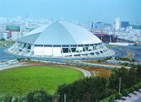
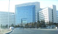
تشانغتشون
Changchun
长春市 | |
|---|---|
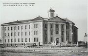
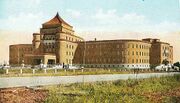
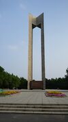
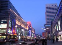
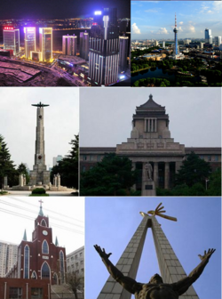 Clockwise from top: panoramic view from Shengtai Plaza, panoramic view of Ji Tower, Former Manchukuo State Department, Statue on cultural square, Changchun Christian Church, Soviet martyr monument. | |
| الكنية: 北国春城 (Spring City of the Northern Country) | |
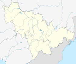
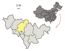 Location of Changchun City (yellow) in Jilin (light grey) and China | |
| الإحداثيات (Jilin People's Government): 43°53′49″N 125°19′34″E / 43.897°N 125.326°E | |
| Country | China |
| Province | Jilin |
| County-level divisions | 7 districts 2 county-level divisions 1 county |
| Incorporated (town) | 1889 |
| Incorporated (city) | 1932 |
| Municipal seat | Nanguan District |
| الحكومة | |
| • النوع | Sub-provincial city |
| • الكيان | Changchun Municipal People's Congress |
| • CCP Secretary | vacant اعتبارا من مارس 2021[تحديث] |
| • Congress Chairman | Wang Zhihou |
| • Mayor | Zhang Zhijun |
| • CPPCC Chairman | Qi Yuanfang |
| المساحة | |
| • Prefecture-level & Sub-provincial city | 24٬734 كم² (9٬550 ميل²) |
| • الحضر (2017)[2] | 1٬855٫00 كم² (716٫22 ميل²) |
| • العمران | 1٬855٫00 كم² (716٫22 ميل²) |
| المنسوب | 222 m (730 ft) |
| التعداد (2020 census)[3] | |
| • Prefecture-level & Sub-provincial city | 9٬066٬906 |
| • الكثافة | 370/km2 (950/sq mi) |
| • Urban | 5٬691٬024 |
| • الكثافة الحضرية | 3٬100/km2 (7٬900/sq mi) |
| • العمرانية | 5٬019٬477 |
| • الكثافة العمرانية | 2٬700/km2 (7٬000/sq mi) |
| منطقة التوقيت | UTC+8 (China Standard) |
| Postal code | 130000 |
| مفتاح الهاتف | 0431 |
| ISO 3166 code | CN-JL-01 |
| License plate prefixes | 吉A |
| GDP (2017) | CNY 653.0 billion |
| - per capita | CNY 86,931 |
| الموقع الإلكتروني | www.changchun.gov.cn |
| [4] | |
| تشانغتشون | |||
|---|---|---|---|
 "Changchun" in Simplified Chinese characters | |||
| الاسم الصيني | |||
| الصينية المبسطة | 长春 | ||
| الصينية التقليدية | 長春 | ||
| Hanyu Pinyin | Chángchūn | ||
| المعنى الحرفي | "Long Spring" | ||
| |||
| Hsinking | |||
| الصينية | 新京 | ||
| Hanyu Pinyin | Xīnjīng | ||
| المعنى الحرفي | New Capital | ||
| |||
| Manchu name | |||
| Manchu script | ᠴᠠᠨᡤᠴᠣᠨ | ||
| Romanization | Cangcon | ||
تشانغتشون أو چانگچون ( Changchun ؛ UK /tʃæŋˈtʃʊn/, الأمريكي /tʃɒŋʔ/;[5] Chinese: 长春) هي عاصمة وأكبر مدن مقاطعة جيلين، الواقعة في شمال شرق الصين.[6] وتقع في وسط سهل سونگلياو. وتـُدار كمدينة تحت إقليمية، وتتكون من سبع مديريات وناحية وثلاثت مدن بمستوى ناحية.[7] According to the 2020 census of China, Changchun had a total population of 9,066,906 under its jurisdiction. The city's metro area, comprising 5 districts and 1 development area وقد بلغ تعدادها 5,019,477 في 2020، إذ أن مديريتي Shuangyang و جيوتاي لم يُعتبرا من الحضر بعد. وهي واحدة من أكبر المدن في شمال شرق الصين، مع Shenyang, Dalian and Harbin.
The name of the city means "long spring" in Chinese. Between 1932 and 1945, Changchun was renamed Xinjing (Chinese: 新京; pinyin: Xīnjīng; lit. 'new capital') or Hsinking by the Kwantung Army as it became the capital of the Imperial Japanese puppet state of Manchukuo, occupying modern Northeast China. After the foundation of the People's Republic of China in 1949, Changchun was established as the provincial capital of Jilin in 1954.
Known locally as China's "City of Automobiles",[8] Changchun is an important industrial base with a particular focus on the automotive sector.[9] Because of its key role in the domestic automobile industry, Changchun was sometimes referred to as the "Detroit of China."[10] Apart from this industrial aspect, Changchun is also one of four "National Garden Cities" awarded by the Ministry of Construction of P.R. China in 2001 due to its high urban greening rate.[8][المصدر لا يؤكد ذلك]
Changchun is also one of the top 40 cities in the world by scientific research as tracked by the Nature Index according to the Nature Index 2020 Science Cities.[11] The city is home to several major universities, notably Jilin University and Northeast Normal University, members of China's prestigious universities in the Double First Class University Plan.
الاسم أصله من لغة جورچن.
التاريخ
التاريخ المبكر
بدأت چانگچون كبلدة صغيرة للتجارة. وفي 1800، اختار الامبراطور جياچينگ من أسرة تشينگ قرية صغيرة على الضفة الشرقية لنهر ييتونگ وسماها "چانگچون تينگ". وفي 1889، رُقـِّيت إلى "چانگچون فو".[12]
At the end of the 18th century peasants from overpopulated provinces such as Shandong and Hebei began to settle in the region. In 1889, the village was promoted into a city known as "Changchun Fu".[13]
مانچوكو والحرب العالمية الثانية
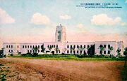
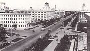
On 10 March 1932 the capital of Manchukuo, a Japan-controlled puppet state in Manchuria, was established in Changchun.[14] The city was then renamed Hsinking (Chinese: 新京; pinyin: Xīnjīng; Wade–Giles: Hsin-ching; Japanese:Shinkyō; literally "New Capital") on 13 March.[15] The Emperor Puyi resided in the Imperial Palace (Chinese: 帝宮; pinyin: Dì gōng) which is now the Museum of the Manchu State Imperial Palace. During the Manchukuo period, the region experienced harsh suppression, brutal warfare on the civilian population, forced conscription and labor and other Japanese sponsored government brutalities; at the same time a rapid industrialisation and militarisation took place. Hsinking was a well-planned city with broad avenues and modern public works. The city underwent rapid expansion in both its economy and infrastructure. Many of buildings built during the Japanese colonial era still stand today, including those of the Eight Major Bureaus of Manchukuo (Chinese: 八大部; pinyin: Bādà bù) as well as the Headquarters of the Japanese Kwantung Army.
إنشاء Hsinking
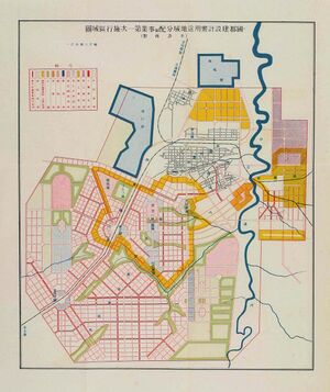
Hsinking was the only Direct-controlled municipality (特别市) in Manchukuo after Harbin was incorporated into the jurisdiction of Binjiang Province.[16] In March 1932, the Inspection Division of South Manchuria Railway started to draw up the Metropolitan Plan of Great Hsinking (simplified Chinese: 大新京都市计画; traditional Chinese: 大新京都市計畫; pinyin: Dà xīn jīngdū shì jìhuà). The Bureau of capital construction (国都建设局; 國都建設局; Guódū jiànshè jú) which was directly under the control of State Council of Manchukuo was established to take complete responsibility of the formulation and the implementation of the plan.[17] Kuniaki Koiso, the Chief of Staff of the Kwantung Army, and Yasuji Okamura, the Vice Chief-of-Staff, finalized the plan of a 200 km2 (77 sq mi) construction area. The Metropolitan Plan of Great Hsinking was influenced by the renovation plan of Paris in the 19th century, the garden city movement, and theories of American cities' planning and design in the 1920s. The city development plan included extensive tree planting. By 1934 Hsinking was known as the Forest Capital with Jingyuetan Park built, which is now China's largest Plantation and a AAAA-rated recreational area.[18]
In accordance with the Metropolitan Plan of Great Hsinking, the area of publicly shared land (including the Imperial Palace, government offices, roads, parks and athletic grounds) in Hsinking was 47 km2 (18 sq mi), whilst the area of residential, commercial and industrial developments was planned to be 53 km2 (20 sq mi).[19] However, Hsinking's population exceeded the prediction of 500,000 by 1940. In 1941, the Capital Construction Bureau modified the original plan, which expanded the urban area to 160 km2 (62 sq mi). The new plan also focused on the construction of satellite towns around the city with a planning of 200 m2 (2,200 sq ft) land per capita.[17] Because the effects of war, the Metropolitan Plan of Great Hsinking remained unfinished. By 1944, the built up urban area of Hsinking reached 80 km2 (31 sq mi), while the area used for greening reached 70.7 km2 (27.3 sq mi). As Hsinking's city orientation was the administrative center and military commanding center, land for military use exceeded the originally planned figure of 9 percent, while only light manufacturing including packing industry, cigarette industry and paper-making had been developed during this period. Japanese force also controlled Hsinking's police system, instead of Manchukuo government.[20] Major officers of Hsinking police were all ethnic Japanese.[21]
The population of Hsinking also experienced rapid growth after being established as the capital of Manchukuo. According to the census in 1934 taken by the police agency, the city's municipal area had 141,712 inhabitants.[22] By 1944 the city's population had risen to 863,607,[23] with 153,614 Japanese settlers. This population amount made Hsinking the third largest metropolitan city in Manchukuo after Mukden and Harbin, as the metropolitan mainly focused on military and political function.[24]
Japanese chemical warfare agents
In 1936, the Imperial Japanese Army established Unit 100 to develop plague biological weapons, although the declared purpose of Unit 100 was to conduct research about diseases originating from animals.[25] During the Second Sino-Japanese War (1937–1945) and World War II the headquarters of Unit 100 ("Wakamatsu Unit") was located in downtown Hsinking, under command of veterinarian Yujiro Wakamatsu.[26] This facility was involved in research of animal vaccines to protect Japanese resources, and, especially, biological-warfare. Diseases were tested for use against Soviet and Chinese horses and other livestock. In addition to these tests, Unit 100 ran a bacteria factory to produce the pathogens needed by other units. Biological sabotage testing was also handled at this facility: everything from poisons to chemical crop destruction.
حصار چانگچون
 مقالة مفصلة: حصار چانگچون
On 20 August 1945 the city was captured by the Soviet Red Army and renamed Changchun.[27] The Russians maintained a presence in the city during the Soviet occupation of Manchuria until 1946.
National Revolutionary Army forces under Zheng Dongguo occupied the city in 1946، إلا أنهم لم يستطيعوا الاحتفاظ بالريف المحيط بها أمام قوات لين بياو من جيش التحرير الشعبي (الشيوعيين)، أثناء الحرب الأهلية الصينية.
The city fell to the Chinese Communist Party in 1948 after the five-month Siege of Changchun, and the communist victory was a turning point which allowed an offensive to capture the remainder of Mainland China.[28] Between 10 and 30 percent[29] of the civilian population starved to death under the siege; estimates range from 150,000[30] to 330,000.[31] اعتبارا من 2015[تحديث] the PRC government avoids all mention of the siege.[32]
وقد سقطت المدينة في أيدي الشيوعيين في 1948 بعد حصار دام خمسة أشهر من قِبل جيش التحرير الشعبي الذي أسفر عن مجاعة هائلة راح ضحيتها من 100,000 إلى 300,000 قتيل. الحقائق عن الحصار ما زالت موضع رقابة رسمية في جمهورية الصين الشعبية.[33]
في عصر الجمهورية الشعبية
غيرت حكومة جمهورية الصين الشعبية اسم المدينة إلى چانگچون، وأصبحت عاصمة مقاطعة جيلين في 1954.
من عقد 1950، اُختيرت چانگچون لتصبح مركزاً لصناعة السيارات في الصين. وقد بدأ بناء أشغال السيارات الأولى في 1953 وبدأ انتاج الشاحنة جيهفانگ CA-10، المبنية على تصميم ZIS-150 السوڤيتية في 1956. وفي 1958، قدمت FAW السيارة الليموزين الشهيرة هونگچي (العلم الأحمر).
استضافت چانگچون الألعاب الآسيوية الشتوية 2007.
الجغرافيا
| چانگچون | ||||||||||||||||||||||||||||||||||||||||||||||||||||||||||||
|---|---|---|---|---|---|---|---|---|---|---|---|---|---|---|---|---|---|---|---|---|---|---|---|---|---|---|---|---|---|---|---|---|---|---|---|---|---|---|---|---|---|---|---|---|---|---|---|---|---|---|---|---|---|---|---|---|---|---|---|---|
| جدول طقس (التفسير) | ||||||||||||||||||||||||||||||||||||||||||||||||||||||||||||
| ||||||||||||||||||||||||||||||||||||||||||||||||||||||||||||
| ||||||||||||||||||||||||||||||||||||||||||||||||||||||||||||
المناخ
| أخفClimate data for چانگچون | |||||||||||||
|---|---|---|---|---|---|---|---|---|---|---|---|---|---|
| Month | Jan | Feb | Mar | Apr | May | Jun | Jul | Aug | Sep | Oct | Nov | Dec | Year |
| Mean daily maximum °C (°F) | −9.6 (14.7) |
−4.9 (23.2) |
3.7 (38.7) |
14.1 (57.4) |
21.4 (70.5) |
26.1 (79.0) |
27.6 (81.7) |
26.4 (79.5) |
21.3 (70.3) |
12.8 (55.0) |
1.7 (35.1) |
−6.6 (20.1) |
11.2 (52.2) |
| Mean daily minimum °C (°F) | −19.7 (−3.5) |
−15.8 (3.6) |
−7.4 (18.7) |
1.9 (35.4) |
9.3 (48.7) |
15.5 (59.9) |
19.1 (66.4) |
17.3 (63.1) |
10.1 (50.2) |
1.9 (35.4) |
−7.8 (18.0) |
−16 (3) |
0.7 (33.3) |
| Average precipitation mm (inches) | 3.2 (0.13) |
4.5 (0.18) |
12.3 (0.48) |
21.9 (0.86) |
49.9 (1.96) |
99.7 (3.93) |
161.1 (6.34) |
121.6 (4.79) |
51.9 (2.04) |
28.9 (1.14) |
10.3 (0.41) |
5.0 (0.20) |
570.4 (22.46) |
| Average precipitation days (≥ 0.1 mm) | 3.7 | 4.6 | 5.5 | 7.1 | 9.8 | 13.6 | 15.4 | 12.4 | 8.8 | 6.7 | 5.7 | 5.4 | 98.7 |
| Average relative humidity (%) | 66 | 61 | 53 | 49 | 51 | 65 | 78 | 79 | 69 | 61 | 63 | 66 | 63.4 |
| Mean monthly sunshine hours | 188.5 | 195.3 | 239.2 | 241.3 | 261.2 | 247.6 | 220.3 | 235.2 | 234.8 | 214.3 | 174.6 | 164.3 | 2٬616٫7 |
| Source: China Meteorological Administration | |||||||||||||
الأقسام الادارية
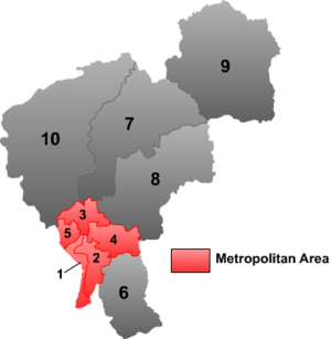
المدينة تحت الإقليمية چانگچون تضم مسئولية مباشرة عن 6 districts (区 qu), 3 county-level cities (市 shi) and 1 County (县 xian):
| الخريطة | # | الاسم | هانزي | هانيو پنين | التعداد (تق. 2003) | المساحة (كم²) | الكثافة (/كم²) |
|---|---|---|---|---|---|---|---|
| |||||||
| المدينة نفسها | |||||||
| 1 | Chaoyang District | 朝阳区 | Cháoyáng Qū | 740,000 | 379 | 1,953 | |
| 2 | Nanguan District | 南关区 | Nánguān Qū | 610,000 | 497 | 1,227 | |
| 3 | Kuancheng District | 宽城区 | Kuānchéng Qū | 470,000 | 877 | 536 | |
| 4 | Erdao District | 二道区 | Èrdào Qū | 390,000 | 965 | 404 | |
| 5 | Luyuan District | 绿园区 | Lùyuán Qū | 570,000 | 301 | 1,894 | |
| Suburb | |||||||
| 6 | Shuangyang District | 双阳区 | Shuāngyáng Qū | 380,000 | 1,663 | 229 | |
| Satellite cities | |||||||
| 7 | Dehui | 德惠市 | Déhuì Shì | 920,000 | 3,096 | 297 | |
| 8 | Jiutai | 九台市 | Jiǔtái Shì | 830,000 | 2,875 | 289 | |
| 9 | Yushu | 榆树市 | Yúshù Shì | 1,230,000 | 4,691 | 262 | |
| Rural | |||||||
| 10 | Nong'an County | 农安县 | Nóng'ān Xiàn | 1,120,000 | 5,221 | 215 | |
الاقتصاد
الجامعات والكليات
- جامعة جيلين (simplified Chinese: 吉林大学; traditional Chinese: 吉林大學)
- Northeast Normal University (simplified Chinese: 东北师范大学; traditional Chinese: 東北師範大學)
- جامعة چانگچون للتكنولوجيا (simplified Chinese: 长春工业大学; traditional Chinese: 長春工業大學)
- جامعة چانگچون للعلوم والتكنولوجيا (simplified Chinese: 长春理工大学; traditional Chinese: 長春理工大學)
- جامعة جيلين الزراعية (simplified Chinese: 吉林农业大学; traditional Chinese: 吉林農業大學)
- جامعة چانگچون العادية (simplified Chinese: 长春师范大学; traditional Chinese: 長春師範大學)
- Jilin Huaqiao Institute [web site http://www.hqwy.com/hqwy/] (simplified Chinese: 吉林华桥外语学院; traditional Chinese: 吉林華僑外語學院, a private college offering bachelor study programs in foreign languages, international trade management and didactics)
- جامعة چانگچون (simplified Chinese: 长春大学; traditional Chinese: 長春大學)
العلاقات الدولية
المدن الشقيقة
چانگچون متوأمة مع:
 منسك، بلاروس (منذ 1992)
 مدينة كويبك, كويبك, كندا
 وينزر، اونتاريو, كندا
 ڤولفسبورگ، ألمانيا (منذ 2006)
 سنداي, ميياگي، اليابان (منذ 1980)
 ماسترتون, نيوزيلندا
 چليابينسك, روسيا
 نوڤوسيبيرسك, روسيا
 سانت پطرسبورگ، روسيا
 اولان اوده, روسيا (منذ 2000)
 نوڤي صاد, صربيا
 Žilina, سلوڤاكيا
 اولسان, كوريا الجنوبية (منذ 1994)
 برمنگهام, المملكة المتحدة
 فلنت، مشيگن، الولايات المتحدة
 ليتل روك، أركنسو، الولايات المتحدة
 ستوننگتن، كنتيكت، الولايات المتحدة
 نوؤك، گرينلاند
انظر أيضاً
الهامش
- ^ خطأ استشهاد: وسم
<ref>غير صحيح؛ لا نص تم توفيره للمراجع المسماةGeographic Location - ^ Ministry of Housing and Urban-Rural Development, ed. (2019). China Urban Construction Statistical Yearbook 2017. Beijing: China Statistics Press. p. 50. Retrieved 11 January 2020.
- ^ "China: Jílín (Prefectures, Cities, Districts and Counties) - Population Statistics, Charts and Map". Archived from the original on 23 September 2014.
- ^ خطأ استشهاد: وسم
<ref>غير صحيح؛ لا نص تم توفيره للمراجع المسماةGDP - ^ "Changchun". Lexico UK English Dictionary. Oxford University Press. Archived from the original on 19 May 2021.
- ^ "Illuminating China's Provinces, Municipalities and Autonomous Regions-Jilin". PRC Central Government Official Website. 2001. Archived from the original on 19 June 2014. Retrieved 22 April 2014.
- ^ 中央机构编制委员会印发《关于副省级市若干问题的意见》的通知. 中编发[1995]5号. 豆丁网 (in الصينية). 1995-02-19. Archived from the original on 29 May 2014. Retrieved 28 May 2014.
- ^ أ ب "Changchun (Jilin) City Information". HKTDC Research. Archived from the original on 8 January 2015.
- ^ "Changchun Business Guide – Economic Overview". echinacities.com. Retrieved 26 July 2012.[dead link]
- ^ خطأ استشهاد: وسم
<ref>غير صحيح؛ لا نص تم توفيره للمراجع المسماةChangchun: China's Detroit - ^ "Nature Index 2020 Science Cities | Supplements | Nature Index". www.natureindex.com. Retrieved 2020-10-16.
- ^ 新京特別市公署『新京市政概要』12–13頁、新京商工公会刊『新京の概況 建国十周年記念發刊』1–7頁、『満洲年鑑』昭和20年(康徳12年)版 389–390頁、他を参照。[استشهاد ناقص]
- ^ "History". Changchun Municipal Government. Archived from the original on 12 May 2012. Retrieved 23 July 2012.
- ^ 大同元年4月1日国務院佈告第1号「満洲国国都ヲ長春ニ奠ム」(大同元年3月10日)
- ^ 大同元年4月1日国務院佈告第2号「国都長春ヲ新京ト命名ス」(大同元年3月14日)
- ^ 「特別市指定ニ関スル件廃止ニ関スル件」(康徳4年6月27日勅令第142号)
- ^ أ ب 国務院国都建設局『國都大新京』(日譯)16頁[استشهاد ناقص]
- ^ 長春浄月潭. j.people.com.cn (in اليابانية). 人民網日本株式会社事業案内. 26 March 2010. Archived from the original on 5 January 2016. Retrieved 17 October 2014.
- ^ 新京特別市公署『新京市政概要』6頁[استشهاد ناقص]
- ^ 首都警察廳正式成立ノ件(大同元年10月18日民政部訓令第286号)
- ^ 後に「首都警察廳官制中改正ノ件」(康徳4年9月30日勅令第282号)により、新京特別市のみを管轄とした。
- ^ 新京特別市公署『新京市政概要』7頁[استشهاد ناقص]
- ^ 『満洲年鑑』昭和20年(康徳12年)版、1944年、389頁[استشهاد ناقص]
- ^ 『満洲年鑑』等では「新京市政公署」の記述も見られる。
- ^ 侵华日军使用细菌武器述略 (in الصينية). 人民日报社. 2005-06-16. Archived from the original on 13 May 2013. Retrieved 28 January 2013.
- ^ Harris, Sheldon H. Factories of Death: Japanese Biological Warfare, 1932–45 , and the American Cover-Up. London: Routledge, 1994.
- ^ LTC David M. Glantz, "August Storm: The Soviet 1945 Strategic Offensive in Manchuria" Archived 23 يوليو 2011 at the Wayback Machine. Leavenworth Papers No. 7, Combat Studies Institute, February 1983, Fort Leavenworth Kansas.
- ^ Dikötter, Frank. (2013). The Tragedy of Liberation: A History of the Chinese Revolution, 1945-1957 (1 ed.). London: Bloomsbury Press. pp. 3–8. ISBN 978-1-62040-347-1.
- ^ China Is Wordless on Traumas of Communists' Rise Archived 8 يناير 2017 at the Wayback Machine, Andrew Jacobs, New York Times, 1 October 2009
- ^ Pomfret, John (2009-10-02). Red Army Starved 150,000 Chinese Civilians. Archived from the original on 25 October 2011. Retrieved 23 June 2014.
{{cite book}}:|work=ignored (help) - ^ Chang, Jung; Halliday, Jon. 2006. Mao: The Unknown Story. London: Vintage Books. p383.
- ^ Jacobs, Andrew (2009-10-02). "China Is Wordless on Traumas of Communists' Rise". The New York Times. Archived from the original on 1 November 2012. Retrieved 2 October 2009.
- ^ Jacobs, Andrew (2009-10-02). "China Is Wordless on Traumas of Communists' Rise". New York Times. Retrieved 2009-10-02.
مصادر
وصلات خارجية
- Pages using gadget WikiMiniAtlas
- CS1 uses الصينية-language script (zh)
- CS1 الصينية-language sources (zh)
- Articles with dead external links from August 2017
- Articles containing Japanese language text
- Articles with incomplete citations from August 2019
- All articles with incomplete citations
- Articles with incomplete citations from February 2020
- CS1 uses اليابانية-language script (ja)
- CS1 اليابانية-language sources (ja)
- Articles containing صينية-language text
- CS1 errors: periodical ignored
- Articles with hatnote templates targeting a nonexistent page
- Short description is different from Wikidata
- Coordinates on Wikidata
- مقالات فيها عبارات متقادمة منذ مارس 2021
- جميع المقالات التي فيها عبارات متقادمة
- Articles containing simplified Chinese-language text
- Articles containing Chinese-language text
- مقالات ذات عبارات بحاجة لمصادر
- Articles containing traditional Chinese-language text
- مقالات فيها عبارات متقادمة منذ 2015
- چانگچون
- مدن في جيلين
- عواصم المقاطعات في الصين
- Capitals of former nations
- Planned cities in China
- صفحات مع الخرائط
