مدينة جيلين
جيلين
吉林市 Jilin, Chi-lin, Kirin | |
|---|---|
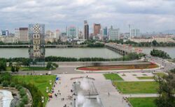 جسر جيلين وميدان القرن | |
| الكنية: مدينة النهر (江城) | |
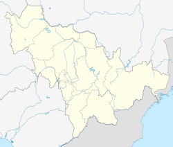
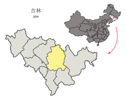 موقع مدينة جيلين (صفراء) في مقاطعة جيلين (رمادي فاتح) والصين | |
| الإحداثيات (حكومة مدينة جيلين): 43°50′17″N 126°32′59″E / 43.8381°N 126.5497°E | |
| البلد | جمهورية الصين الشعبية |
| المقاطعة | جيلين |
| تقسيمات بمستوى ناحية | 9 |
| مقر البلدية | Chuanying District |
| الحكومة | |
| • النوع | مدينة بمستوى محافظة |
| • أمين CPC بمدينة جيلين | Zhao Jingbo (赵静波) |
| • العمدة | Zhang Huanqiu (张焕秋) |
| المساحة | |
| • مدينة بمستوى محافظة | 27٬166٫37 كم² (10٬488٫99 ميل²) |
| • الحضر | 3٬663٫9 كم² (1٬414٫6 ميل²) |
| • العمران | 3٬663٫9 كم² (1٬414٫6 ميل²) |
| المنسوب | 202 m (663 ft) |
| التعداد (تعداد 2020)[1] | |
| • مدينة بمستوى محافظة | 3٬623٬713 |
| • الكثافة | 130/km2 (350/sq mi) |
| • Urban | 1٬895٬865 |
| • الكثافة الحضرية | 520/km2 (1٬300/sq mi) |
| • العمرانية | 1٬895٬865 |
| • الكثافة العمرانية | 520/km2 (1٬300/sq mi) |
| منطقة التوقيت | UTC+8 (الصين القياسي) |
| Postal code | 132000 |
| مفتاح الهاتف | 0432 |
| ISO 3166 code | CN-JL-02 |
| GDP per capita | ¥42,900 (2010) |
| القوميات الرئيسية | هان، مانشو، كوريون، هوي |
| لوحات السيارات | 吉B |
| الموقع الإلكتروني | www |
| Jilin | |||
|---|---|---|---|
 "جيلين"، كما تُكتب بالصينية | |||
| الاسم الصيني | |||
| الصينية | 吉林 | ||
| البريد | Kirin | ||
| |||
| Manchu name | |||
| Manchu script | ᡤᡳᡵᡳᠨ ᡠᠯᠠ ᡥᠣᡨᠣᠨ | ||
| Romanization | Girin'ula hoton | ||
مدينة جيلين أو جيلين (Chinese: 吉林市; pinyin: Jílín Shì؛ نطق المندرين: [tɕǐlǐn])، الرومنة البديلة هي كيرين Kirin (المانچو: ᡤᡳᡵᡳᠨ, أصد:/ki.rin/)، هي ثاني أكبر مدينة والعاصمة السابقة لمقاطعة جيلين في شمال شرق الصين. وفي إحصاء 2020، كان هناك 3,623,713 نسمة يقيمون ضمن النطاق الإداري الذي تبلغ مساحته 27166.37 كم² بالإضافة إلى 1,895,865 نسمة في الضواحي العمرانية المكونة من أربع مديريات. وبكونها مدينة بمستوى محافظة، فهي المدينة الرئيسية الوحيدة التي تتقاسم اسمها مع مقاطعتها.
كما تُعرف مدينة جيلين بكنية مدينة النهر لأن نهر سونجهوا يحيط بمعظم المدينة. وفي 2007، شاركت في استضافة الألعاب الشتوية الآسيوية.
التاريخ
مدينة جيلين هي واحدة من أقدم المدن في شمال شرق الصين.[بحاجة لمصدر]
During the reign of the Yongle Emperor in the Ming dynasty, efforts were made to expand Ming control throughout all of Manchuria. Mighty river fleets were built and sailed several times from Jilin City, getting the chieftains of the local tribes to swear allegiance to the Ming rulers.[2] Soon after the establishment of the Manchu-led Qing dynasty, the territory of today's Primorsky Kray was put under the administration of Jilin. As the Russian Empire advanced eastward to the Pacific coast, the Qing government ordered a naval shipbuilding factory to be set up here in 1661. Jilin was officially established as a fort city in 1673 when Anzhuhu (安珠瑚), the Deputy Lieutenant-General (副都统), was ordered to build a castle in Jilin. In 1676, the Military Governor of Ninguta was transferred to Jilin City because of its more convenient location and increasing military importance, while the former Deputy Lieutenant-General was transferred in the opposite direction to Ninguta.[3] Since then Jilin City has developed at a rapid pace. The nickname of Jilin City is River City (江城), which originates from one sentence "连樯接舰屯江城" of a poem written by Kangxi Emperor when he was visiting Jilin City in 1682. Jilin retained its importance into the 18th and 19th century as one of the few cities existing beyond the Willow Palisade, along with Tsitsihar, Ninguta and Mukden.
After Manchukuo established their capital in Hsinking (present-day Changchun), Jilin City's importance decreased. By 1940, Jilin's population was 173,624, while Hsinking's population reached 544,202 at the same time.[4][استشهاد ناقص] Soviet forces captured Jilin during the August Storm operation.[5]
Jilin became the provincial capital of Jilin Province after the establishment of the People's Republic of China in 1949, until Changchun took this position in 1956.
الجغرافيا

Jilin City, which is located in central Jilin Province spanning from 125° 40' to 127° 56' E longitude and 42° 31' to 44° 40' N latitude. Neighbouring prefectures are:
- هاربين، خـِيْلونگجيانگ (N)
- تشانج تشون (W)
- Siping (W)
- Yanbian (E)
- لياويوان (S)
- Tonghua (S)
- Baishan (S)
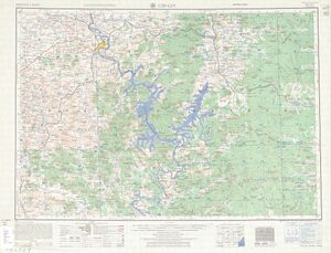
تقع مدينة جيلين في منطقة تلال قريبة من نهر سونجهوا. There are four famous mountains surrounding Jilin City, which is North Mountain in the west, Long Tan Mountain in the east, Zhuque Mountain in the North, and Turtle Mountain in the south, plus Songhua River, it forms a bagua in Taiji pattern. North Mountain, called Beishan, is the most famous mountain in Jilin City and is home to several Buddhist Temples. The Qianlong Emperor reportedly visited the mountain.
المناخ
Jilin City has a four-season, monsoon-influenced, humid continental climate (Köppen Dwa). Winters are long (lasting from November to March), cold, and windy, but dry, due to the influence of the Siberian anticyclone, with a January mean temperature of −16.7 °C (1.9 °F). Spring and autumn are somewhat short transitional periods, with some precipitation, but are usually dry and windy. Summers are hot and humid, with a prevailing southeasterly wind due to the East Asian monsoon; July averages 22.9 °C (73.2 °F). Snow is usually light during the winter, and annual rainfall is heavily concentrated from June to August.
| أخفClimate data for مدينة جيلين (1981–2010 normals) | |||||||||||||
|---|---|---|---|---|---|---|---|---|---|---|---|---|---|
| Month | Jan | Feb | Mar | Apr | May | Jun | Jul | Aug | Sep | Oct | Nov | Dec | Year |
| Record high °C (°F) | 5.4 (41.7) |
12.8 (55.0) |
20.0 (68.0) |
30.6 (87.1) |
34.8 (94.6) |
35.1 (95.2) |
35.4 (95.7) |
35.7 (96.3) |
30.4 (86.7) |
27.9 (82.2) |
19.6 (67.3) |
11.5 (52.7) |
35.7 (96.3) |
| Mean daily maximum °C (°F) | −9.5 (14.9) |
−4.3 (24.3) |
3.8 (38.8) |
14.6 (58.3) |
21.6 (70.9) |
26.3 (79.3) |
27.7 (81.9) |
26.8 (80.2) |
21.9 (71.4) |
13.8 (56.8) |
2.2 (36.0) |
−6.3 (20.7) |
11.5 (52.8) |
| Daily mean °C (°F) | −16.7 (1.9) |
−11.5 (11.3) |
−2.1 (28.2) |
8.0 (46.4) |
15.1 (59.2) |
20.5 (68.9) |
22.9 (73.2) |
21.7 (71.1) |
15.2 (59.4) |
7.1 (44.8) |
−3.4 (25.9) |
−12.6 (9.3) |
5.3 (41.6) |
| Mean daily minimum °C (°F) | −22.9 (−9.2) |
−18.2 (−0.8) |
−7.8 (18.0) |
1.6 (34.9) |
8.5 (47.3) |
14.9 (58.8) |
18.4 (65.1) |
17.0 (62.6) |
8.9 (48.0) |
1.2 (34.2) |
−8.7 (16.3) |
−18.3 (−0.9) |
−0.4 (31.2) |
| Record low °C (°F) | −40.3 (−40.5) |
−37.3 (−35.1) |
−27.0 (−16.6) |
−12.1 (10.2) |
−7.5 (18.5) |
5.0 (41.0) |
10.7 (51.3) |
5.3 (41.5) |
−4.1 (24.6) |
−15.6 (3.9) |
−29.1 (−20.4) |
−36.4 (−33.5) |
−40.3 (−40.5) |
| Average precipitation mm (inches) | 5.9 (0.23) |
6.8 (0.27) |
15.3 (0.60) |
28.4 (1.12) |
57.3 (2.26) |
103.2 (4.06) |
164.6 (6.48) |
152.1 (5.99) |
56.6 (2.23) |
28.7 (1.13) |
17.1 (0.67) |
8.6 (0.34) |
644.6 (25.38) |
| Average precipitation days (≥ 0.1 mm) | 5.5 | 6.4 | 7.0 | 9.2 | 12.3 | 15.0 | 16.3 | 13.6 | 10.0 | 7.7 | 6.8 | 7.0 | 116.8 |
| Average relative humidity (%) | 71 | 68 | 60 | 53 | 56 | 66 | 78 | 80 | 73 | 65 | 66 | 70 | 67 |
| Source 1: China Meteorological Administration[6] | |||||||||||||
| Source 2: Weather China (precipitation days 1971–2000)[7] | |||||||||||||
قضايا بيئية
تلوث البنزين في جيلين 2005
The Jilin chemical plant explosions were a series of explosions which occurred on November 13, 2005, in the No.101 Petrochemical Plant in Jilin City, killing six. The explosion severely polluted the Songhua River, with an estimated 100 tons of pollutants containing benzene and nitrobenzene entering into the river.[8] The benzene level recorded was at one point 108 times above national safety levels. This caused downstream major cities including Harbin, Songyuan and Khabarovsk suspending their water supply for almost one week.[9] Chinese leaders later had to apologize to the Russian government over its handling of the incident as the pollutants finally flowed into the Amur (Heilong) River, the major boundary river between China and Russia.[10]
فيضانات وتلوث جيلين 2010
Jilin was one of the worst-hit regions in China by rain and landslides in the 2010 summer China floods.[11] On July 28, 2010, several thousand barrels, which contained toxic chemicals including trimethylsilyl chloride and hexamethyldisiloxane, about 170 kg of a poisonous substance in each, were washed into the Songhua River by the floods from two chemical plants based in Jilin. There were reports that some barrels exploded on contact with water.[12] By late afternoon on August 1, 6,387 barrels had been retrieved from the river. Officials stated that tests show the water in the river remains safe to drink. Three soldiers of the People's Liberation Army in Jilin drowned after working to remove the barrels and control the flooding.[13] The Dahe Dam in Changshan Township was breached on July 28, spilling 4 million m3 of water, destroying five villages downstream and leaving 40 people dead or missing. Over 100 were dead or missing after floods devastated Jilin prefecture. Workers started repairing fifty-one damaged small reservoirs and fortifying riverbanks in the province after the Songhua River surged to levels twice as high as normal.
التقسيمات الإدارية
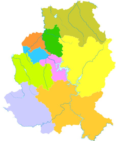
| الخريطة | ||||||
|---|---|---|---|---|---|---|
| # | الاسم | Hanzi | Hanyu Pinyin | Population (2010 census) | Area (km²) | Density (/km²) |
| 1 | Chuanying District | 船营区 | Chuányíng Qū | 659,188 | 711 | 927 |
| 2 | Longtan District | 龙潭区 | Lóngtán Qū | 527,532 | 1209 | 436 |
| 3 | Changyi District | 昌邑区 | Chāngyì Qū | 492,159 | 865 | 569 |
| 4 | Fengman District | 丰满区 | Fēngmǎn Qū | 296,924 | 1032 | 288 |
| 5 | Panshi City | 磐石市 | Pánshí Shì | 505,954 | 3867 | 131 |
| 6 | Jiaohe City | 蛟河市 | Jiāohé Shì | 447,380 | 6235 | 72 |
| 7 | Huadian City | 桦甸市 | Huàdiàn Shì | 444,997 | 6624 | 67 |
| 8 | Shulan City | 舒兰市 | Shūlán Shì | 645,925 | 4554 | 142 |
| 9 | Yongji County | 永吉县 | Yǒngjí Xiàn | 394,622 | 2625 | 150 |
السياحة
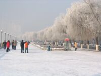
Jilin City is a popular destination for tourists to come each winter to view the magnificent rime ice (雾凇; 霧凇) on trees along the banks of the Songhua River, (the river is the only river in the region that does not freeze in winter). The rime ice is a natural phenomenon that occurs every year during January and February. It is a result of water vapor rising up from the warm Songhua River to meet the cold −20 °C (−4 °F) night air, causing the crystallisation of water vapour on willows branches.
المعالم:
- Meteorite Museum (largest stony meteorite of a documented meteorite fall)
- North Hill (Beishan in Chinese) Park (north-west of Jilin)
- Dragon Pool Mountain Park
- Songhua Lake (south-east of Jilin)
- Wulajie (乌拉街; formerly also transcribed as Wulakai[14]) Old City (44°05′N 126°28′E / 44.083°N 126.467°E), a Qing dynasty walled town in Longtan District, on the east bank of the Sungari River downstream from Jilin's main urban area. The place was the center for collection of local products to the imperial court during the Qing dynasty.[14] In 1682—when, according to Ferdinand Verbiest, Wulajie (Ula) was "the most illustrious city of the whole province"—the Kangxi Emperor himself visited the place to enjoy sturgeon fishing.[15] These days, a public school nearby is one of the few schools in the country where some Manchu is taught.[16][17]
الرياضة
The winter sports in Jilin City are full of interests, such as skiing, skating, sledding, snowboarding, and winter swim. Winter swimming is widely practiced in Jilin city.
Ski resorts:
- Beidahu ski resort
- Lake Songhua ski resort
- North Hill ski resort (北山滑雪场)
- Zhuque Hill ski resort
- Wujiashan ski resort
- Filibiin swimming resort
التعليم
المدارس الثانوية
- Jilin City No.1 High School
- Jilin Yuwen High School
- Ararsame Second High School
الجامعات والكليات
- Beihua University
- Northeast Dianli University
- Jilin Institute of Chemical Technology
- Jilin Agriculture University
- Jilin Medical College
النقل
الجو
The city used to be served by the Jilin Ertaizi Airport (IATA: JIL, ICAO: ZYJL). But by October 3, 2005, all of its commercial flights were transferred to the newly opened Changchun Longjia International Airport while Jilin Airport halted operation.[18]
The airport is located about 76 km (47 mi) away from the Jilin City and has flights to many cities from the airport. China Southern Airlines also provide some international connections directly from Changchun.
السكك الحديدية
Jilin is served by the Jilin railway station. Jilin railway station is on the East-West Changchun-Tumen Railway mainline and provides convenient access to many cities around China, including Beijing, Tianjin, Dalian, Jinan, Hangzhou. Services to Harbin, Changchun and Shenyang are also frequent and convenient through the Harbin-Dalian high-speed rail and its branch from Changchun to Jilin.
نقل الشاحنات
العلاقات الدولية
البلدات التوأم والمدن الشقيقة
مدينة جيلين متوأمة مع:
 ناخودكا كراي پريمورسكي، روسيا (1991)
 سپوكان، واشنطن، الولايات المتحدة
 تشركاسي، أوبلاست تشركاسي، أوكرانيا
 أوسترسوند، Jämtland، السويد
 ڤولگوگراد، أوبلاست ڤولگوگراد، روسيا
 ياماگاتا، محافظة ياماگاتا، اليابان[19]
 Chongjin, North Hamgyong, North Korea[20]
انظر أيضاً
المراجع
- ^ "China: Jílín (Prefectures, Cities, Districts and Counties) - Population Statistics, Charts and Map".
- ^ Shih-shan Henry Tsai, The Eunuchs in the Ming Dynasty. SUNY Press, 1996. ISBN 0-7914-2687-4. Partial text on Google Books. P. 129-130
- ^ Edmonds, Richard Louis (1985). Northern Frontiers of Qing China and Tokugawa Japan: A Comparative Study of Frontier Policy. University of Chicago, Department of Geography; Research Paper No. 213. pp. 113, 115–117. ISBN 0-89065-118-3.
- ^ 新京商工公会刊『新京の概況 建国十周年記念發刊』18-19頁
- ^ LTC David M. Glantz, "August Storm: The Soviet 1945 Strategic Offensive in Manchuria" Archived 2011-07-23 at the Wayback Machine. Leavenworth Papers No. 7, Combat Studies Institute, February 1983, Fort Leavenworth Kansas.
- ^ 中国气象数据网 - WeatherBk Data (in Chinese (China)). China Meteorological Administration. Retrieved 2018-11-09.
- ^ 吉林 - 气象数据 (in Chinese (China)). Weather China. Retrieved 2021-11-22.
- ^ "China pledges to minimize impact of river pollution on Russia". Xinhua. 24 November 2005. Archived from the original on April 28, 2006.
- ^ "2nd batch of water purifying materials offered to Russia". www.chinaview.cn. 2005-12-16. Archived from the original on May 14, 2011.
- ^ Spegele, Brian (11 April 2014). "Water Scare Hits Chinese City of Lanzhou". Wall Street Journal. Retrieved 14 April 2014.
- ^ The Associated Press, Canadian Press (August 5, 2010). "Official: More heavy rains to test dikes, put pressure on rescue efforts in northern China". The Canadian Press. Retrieved 6 August 2010.
- ^ Khabarovsk Region prevents poisoned Sungari water from reaching Amur Archived 2012-03-18 at the Wayback Machine, July 30, 2010, Moscow Time
- ^ Zhao, Xinhua (August 1, 2010). "Over 100 Dead or Missing after Floods Devastate NE China". english.cri.cn. Archived from the original on October 19, 2012. Retrieved 6 August 2010.
- ^ أ ب Lattimore, Owen (1933), "Wulakai Tales From Manchuria", The Journal of American Folklore 46 (181): 272–286, doi:. Lattimore explains that kai is simply a local pronunciation of 街 (jiē in most other Mandarin dialects)
- ^ Orléans, Pierre Joseph d'; Verbiest, Ferdinand; Pereira, Thomas (1854), Major, Richard Henry, ed., Tartar conquerors of China. Translated by Francis Egerton Ellesmere (Earl of), Issue 17 of Works issued by the Hakluyt Society, Hakluyt Society, Printed for the Hakluyt Society, pp. 112–113, https://books.google.com/books?id=lOgOAAAAYAAJ&pg=PA112 (This is an English translation of Verbiest's report originally published in French in the early 19th century)
- ^ Echoes of Manchu: Breaking Ground Archived 2011-07-27 at the Wayback Machine
- ^ Echoes of Manchu: Wall Mystery Solved! Archived 2011-07-27 at the Wayback Machine
- ^ China's Ertaizi Airport halts operation Archived 2014-01-13 at the Wayback Machine. Greater China Transport Logistic Insights. October 3, 2005. Retrieved on February 27, 2011.
- ^ 山形市の友好姉妹都市 [Yamagata City Twin Cities] (in اليابانية). Japan: Yamagata City. Archived from the original on 15 April 2012. Retrieved 12 October 2011.
- ^ "Chongjin (D.P.R.K.)". english.jl.gov.cn. 12 April 2011. Archived from the original on 23 October 2017. Retrieved 22 October 2017.
وصلات خارجية
 Jilin City travel guide from Wikivoyage
- Official Jilin City government website (in صينية)
 Chisholm, Hugh, ed. (1911). . دائرة المعارف البريطانية (eleventh ed.). Cambridge University Press.
 {{cite encyclopedia}}: Cite has empty unknown parameter:|coauthors=(help)
- Pages using gadget WikiMiniAtlas
- Articles containing Japanese language text
- CS1 uses الصينية-language script (zh)
- CS1 Chinese (China)-language sources (zh-cn)
- Articles containing صينية-language text
- CS1 uses اليابانية-language script (ja)
- CS1 اليابانية-language sources (ja)
- Short description is different from Wikidata
- Coordinates on Wikidata
- Articles containing simplified Chinese-language text
- Articles containing Manchu-language text
- Articles with unsourced statements from November 2020
- Articles with incomplete citations from January 2020
- All articles with incomplete citations
- Articles with hatnote templates targeting a nonexistent page
- Articles containing traditional Chinese-language text
- Articles with صينية-language sources (zh)
- مقالات المعرفة المحتوية على معلومات من دائرة المعارف البريطانية طبعة 1911
- Jilin City
- Cities in Jilin
- Prefecture-level divisions of Jilin
- Songhua River
