جزر ماريانا الشمالية
16°42′18″N 145°46′48″E / 16.70500°N 145.78000°E
جزر ماريانا الشمالية Northern Mariana Islands | |
|---|---|
| كومنولث جزر ماريانا الشمالية Sankattan Siha Na Islas Mariånas (تشامورو) Commonwealth Téél Falúw kka Efáng llól Marianas (Carolinian) | |
| Anthem: "Gi Talo Gi Halom Tasi" (تشامورو) "Satil Matawal Pacifiko" (Carolinian) ("In the Middle of the Sea") | |
 موقع جزر ماريانا الشمالية (موضح بالدائرة الحمراء) | |
| دولة سيادية | |
| قبل الانتماء للولايات المتحدة | Trust Territory of the Pacific Islands |
| وضع الكومنولث | 9 يناير 1978 |
| End of U.N. Trusteeship | November 4, 1986 |
| العاصمة and largest city | Saipan 15°11′N 145°44′E / 15.19°N 145.74°E |
| اللغات الرسمية | |
| الجماعات العرقية (2010)[1] |
|
| الدين (2010)[2] |
|
| صفة المواطن | Northern Mariana Islander (formal) Northern Marianan (other) Marianan (diminutive form) Chamorro (colloquial)[3] |
| الحكومة | Devolved presidential constitutional dependency |
• Governor | Ralph Torres (R) |
| Arnold Palacios (I) | |
| Legislature | Commonwealth Legislature |
| Senate | |
| House of Representatives | |
| United States Congress | |
| Gregorio Sablan (D) | |
| المساحة | |
• Total | 464[4][5] km2 (179 sq mi) |
• Water (%) | negligible |
| أعلى منسوب | 965 m (3٬166 ft) |
| التعداد | |
• 2022 estimate | 55,650[6] (209th) |
• 2020 census | 47,329[7] |
• Density | 113/km2 (292.7/sq mi) (97th) |
| GDP (PPP) | 2016 estimate |
• Total | $1.24 billion[6] |
• Per capita | $25,516[6] |
| GDP (nominal) | 2019 estimate |
• Total | US$1,182,000,000[8] |
• Per capita | $21,239 |
| العملة | United States dollar (US$) (USD) |
| Time zone | UTC+10:00 (ChST) |
| Date format | mm/dd/yyyy |
| Driving side | right |
| Calling code | +1-670 |
| USPS abbreviation | MP |
| Trad. abbreviation | CNMI |
| ISO 3166 code | |
| Internet TLD | .mp |
| Website | gov |
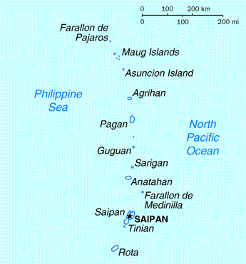
The Northern Mariana Islands, officially the Commonwealth of the Northern Mariana Islands (CNMI; تشامورو: Sankattan Siha Na Islas Mariånas; Carolinian: Commonwealth Téél Falúw kka Efáng llól Marianas), is an unincorporated territory and commonwealth of the United States consisting of 14 islands in the northwestern Pacific Ocean.[9] The CNMI includes the 14 northernmost islands in the Mariana Archipelago; the southernmost island, Guam, is a separate U.S. territory.
The United States Department of the Interior cites a landmass of 183.5 square miles (475.26 km2).[10] According to the 2020 United States Census, 47,329 people were living in the CNMI at that time.[7] The vast majority of the population resides on Saipan, Tinian, and Rota. The other islands of the Northern Marianas are sparsely inhabited; the most notable among these is Pagan, which for various reasons over the centuries has experienced major population flux, but formerly had residents numbering in the thousands.[11][12]
The administrative center is Capitol Hill, a village in northwestern Saipan. However, most[كمية] publications[which?] consider Saipan to be the capital because the island is governed as a single municipality.
التاريخ
وصول البشر
الحيازة الإسپانية
الهجرة الكارولينية
الحيازة الألمانية والانتداب الياباني

الحرب العالمية الثانية
وصاية الأمم المتحدة

الكومنولث

الجغرافيا
المناخ
| أخفClimate data for Saipan | |||||||||||||
|---|---|---|---|---|---|---|---|---|---|---|---|---|---|
| Month | Jan | Feb | Mar | Apr | May | Jun | Jul | Aug | Sep | Oct | Nov | Dec | Year |
| Record high °F (°C) | 87 (31) |
89 (32) |
86 (30) |
87 (31) |
90 (32) |
89 (32) |
89 (32) |
89 (32) |
90 (32) |
88 (31) |
87 (31) |
88 (31) |
90 (32) |
| Mean daily maximum °F (°C) | 81.2 (27.3) |
79.7 (26.5) |
79.8 (26.6) |
83.1 (28.4) |
84.4 (29.1) |
85.0 (29.4) |
84.1 (28.9) |
84.0 (28.9) |
83.8 (28.8) |
83.7 (28.7) |
83.3 (28.5) |
81.4 (27.4) |
82.8 (28.2) |
| Daily mean °F (°C) | 77.3 (25.2) |
76.3 (24.6) |
76.4 (24.7) |
78.5 (25.8) |
79.9 (26.6) |
80.2 (26.8) |
79.6 (26.4) |
79.6 (26.4) |
79.4 (26.3) |
79.3 (26.3) |
79.1 (26.2) |
77.8 (25.4) |
78.6 (25.9) |
| Mean daily minimum °F (°C) | 73.4 (23.0) |
72.9 (22.7) |
73.1 (22.8) |
73.9 (23.3) |
75.5 (24.2) |
75.3 (24.1) |
75.1 (23.9) |
75.2 (24.0) |
75.0 (23.9) |
74.9 (23.8) |
75.0 (23.9) |
74.1 (23.4) |
74.5 (23.6) |
| Record low °F (°C) | 68 (20) |
67 (19) |
64 (18) |
63 (17) |
66 (19) |
70 (21) |
64 (18) |
67 (19) |
67 (19) |
67 (19) |
68 (20) |
68 (20) |
63 (17) |
| Average rainfall inches (mm) | 3.84 (98) |
4.42 (112) |
2.40 (61) |
5.03 (128) |
3.80 (97) |
5.04 (128) |
10.16 (258) |
12.42 (315) |
11.65 (296) |
10.99 (279) |
7.76 (197) |
5.88 (149) |
83.39 (2٬118) |
| Average rainy days (≥ 0.01-inch) | 18 | 16 | 15 | 17 | 18 | 20 | 24 | 24 | 23 | 25 | 21 | 19 | 240 |
| Source: [13] | |||||||||||||
السياسة والحكومة
التقسيمات الإدارية
الوضع السياسي والحكم الذاتي
النظام القضائي
المواطنة
الاقتصاد
جدل العمالة
البنية التحتية
الديموغرافيا
| التعداد التاريخي | |||
|---|---|---|---|
| التعداد | Pop. | %± | |
| 1960 | 8٬286 | — | |
| 1970 | 9٬436 | 13٫9% | |
| 1980 | 16٬780 | 77٫8% | |
| 1990 | 43٬345 | 158٫3% | |
| 2000 | 69٬221 | 59٫7% | |
| 2010 | 53٬883 | −22٫2% | |
| 2020 | 47٬329 | −12٫2% | |
اللغات
الجماعات العرقية
الدين
التعليم
الثقافة
المطبخ
السينما
الرياضة
انظر أيضاً
الهوامش
- ^ The Northern Mariana Islands belongs to, but is not a part of, the United States. See the page for the Insular Cases for more information.
المصادر
- ^ Bureau, U.S. Census. "American FactFinder – Results". factfinder.census.gov (in الإنجليزية). Archived from the original on February 14, 2020. Retrieved January 31, 2018.
- ^ "Northern Mariana Islands".
- ^ "AAPI – Asian American and Pacific Islander – Primer". Environmental Protection Agency. June 28, 2006. Retrieved August 29, 2015.
- ^ خطأ استشهاد: وسم
<ref>غير صحيح؛ لا نص تم توفيره للمراجع المسماةciaworldfactbook - ^ "Our District". Congressman Gregorio Kilili Camacho Sablan Representing the Northern Mariana Islands. Archived from the original on November 5, 2020.
The U.S. Census Bureau reports the total land area of all islands as 179 square miles.
- ^ أ ب ت "Australia-Oceania :: Northern Mariana Islands (Territory of the US)". The World Factbook. Central Intelligence Agency. Retrieved August 26, 2015.
- ^ أ ب ت 2020 Census Population of the Commonwealth of the Northern Mariana Islands: Municipality and Village, U.S. Census Bureau.
- ^ "Northern Mariana Islands | Data". data.worldbank.org. Retrieved August 9, 2021.
- ^ Lin, Tom C.W., Americans, Almost and Forgotten, 107 California Law Review (2019)
- ^ "Commonwealth of the Northern Mariana Islands". US Department of the Interior. Archived from the original on September 26, 2011.
- ^ Todiño, Junhan B. (June 10, 2015). "US military 'not sensitive to indigenous, cultural factors,' says Mayor Aldan". Marianas Variety. Retrieved September 23, 2015.
- ^ Villegas Zotomayor, Alexie (January 15, 2015). "Pagan has 8 residents". Marianas Variety. Retrieved September 23, 2015.
- ^ "NOWData – NOAA Online Weather Data". NOAA. Retrieved February 16, 2015.
- ^ Geography of the Pacific. 1951. p. 208.
- ^ "Coral reef ecosystem monitoring report of the Mariana Archipelago: a 2003 – 2007" (PDF). National Oceanic and Atmospheric Administration. Archived (PDF) from the original on November 15, 2020. Retrieved November 15, 2020.
- ^ "2015 CNMI Statistical Yearbook" (PDF).
- ^ "Über die Marianen". Gaebler Info und Genealogie (in الألمانية). Archived from the original on August 21, 2020.
- ^ You must specify vnum when using {{cite gvp}}.
قراءات إضافية
- The World Factbook, 2000.
- Land areas and population data from United States Census Bureau.
- Northern Mariana Islands and constituent municipalities, United States Census Bureau
وصلات خارجية
![]() تعريفات قاموسية في ويكاموس
تعريفات قاموسية في ويكاموس
![]() كتب من معرفة الكتب
كتب من معرفة الكتب
![]() اقتباسات من معرفة الاقتباس
اقتباسات من معرفة الاقتباس
![]() نصوص مصدرية من معرفة المصادر
نصوص مصدرية من معرفة المصادر
![]() صور و ملفات صوتية من كومونز
صور و ملفات صوتية من كومونز
![]() أخبار من معرفة الأخبار.
أخبار من معرفة الأخبار.
الحكومة
- Commonwealth of the Northern Mariana Islands official website
- The CNMI Covenant
- The CNMI Constitution
- CNMI Office of Resident Representative Pedro A. Tenorio
- H.R. 873 – The Northern Mariana Islands Delegate Act
- H.R. 5550 – The United States-Commonwealth of the Northern Marianas Human Dignity Act
عامة
- U.S. Census Bureau: Island Areas Census 2000
- Northern Mariana Islands. The World Factbook. Central Intelligence Agency.
- جزر ماريانا الشمالية at Curlie
 Wikimedia Atlas of Northern Mariana Islands
 جزر ماريانا الشمالية travel guide from Wikivoyage
وسائل إعلام إخبارية
- KSPN-TV Channel 2 News
- Saipan Tribune
- Marianas Variety
- The Pacific Times
- Food for Thought – Weekly commentary on CNMI society by KZMI and KCNM manager Harry Blalock
أخرى
- The Insular Empire: America in the Mariana Islands, PBS documentary film & website
- Northern Mariana Islands Online Encyclopedia
- USA Department of the Interior – Insular Area Summary for the Northern Mariana Islands
| أظهر قائمة المستعمرات والمحميات الألمانية السابقة |
|---|
- Pages using gadget WikiMiniAtlas
- CS1 الألمانية-language sources (de)
- Short description is different from Wikidata
- Coordinates on Wikidata
- Articles containing تشامورو-language text
- Articles containing Carolinian-language text
- Pages using Lang-xx templates
- كل المقالات ذات العبارات غير المسندة
- مقالات ذات عبارات غير مسندة from April 2021
- All articles with specifically marked weasel-worded phrases
- Articles with specifically marked weasel-worded phrases from April 2021
- Articles with hatnote templates targeting a nonexistent page
- Pages using multiple image with auto scaled images
- Articles with Curlie links
- دول اوقيانوسية
- جزر مارينا الشمالية
- أرخبيلات المحيط الهادي
- أرخبيلات أوقيانوسيا
- بلدان ميكرونيزيا
- المناطق الجزرية في الولايات المتحدة
- بلدان جزر
- جزر أوقيانوسيا
- قوائم الإحداثيات
- Small Island Developing States
- States and territories established in 1898
- 1898 establishments in Oceania
- 1898 establishments in the German colonial empire
- Former colonies in Oceania
- Former German colonies
- Former Japanese colonies
- Former Spanish colonies
- German New Guinea
- South Seas Mandate
- Spanish East Indies
- Trust Territory of the Pacific Islands
- World War II sites
- بلدان وأراضي ناطقة بالإنگليزية


