الغرب الأوسط للولايات المتحدة
(تم التحويل من وسط غرب الولايات المتحدة)
Midwestern United States
Midwest | |
|---|---|
|
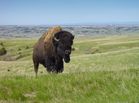
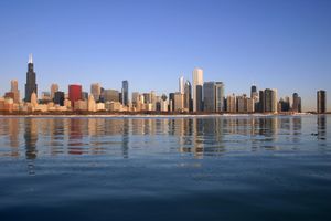
Left-right from top: Chicago skyline, Bison in Badlands National Park, Jay Cooke State Park, Cornfields in Illinois, Gateway Arch, Huron River in the Upper Peninsula, Detroit skyline | |
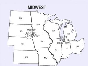
 Regional definitions vary slightly among sources. This map reflects the Midwestern United States as defined by the Census Bureau, which is followed in many sources.[1] | |
| States | |
| Largest metro MSA | |
| Largest cities | |
الغرب الأوسط للولايات المتحدة (ويشار له بالعامة الأمريكية Midwest) هو واحد من أربعة أقاليم جغرافية في الولايات المتحدة الأمركية يستخدمها مكتب التعداد الأمريكي في تقاريره.
ويتكون الاقليم من 12 ولاية في شمال-وسط الولايات المتحدة: إلينوي، إنديانا، أيوا، كانزس، مشيگن، مينسوتا، مزورى ونبراسكا، داكوتا الشمالية، داكوتا الجنوبية، أوهايو ووسكنسن.[2] وفي تقرير مكتب التعدادات 2006، وصل عدد سكان الاقليم 66,217,736. كلا من geographic center of the contiguous U.S. و population center of the U.S. في وسط الغرب. ويقسم مكتب التعداد الأمريكي الاقليم إلى ولايات وسط الغرب الشمالية (وتتكون في الأساس من ولايات البحيرات العظمى) و West North Central States.
التعريف
الجغرافيا الطبيعية
المناطق العمرانية الرئيسية
All cities listed have a population of 250,000 or more.
|
|
|
|
تعداد الولايات
| State | تقدير 2017 | تعداد 2010 | التغير | المساحة | الكثافة |
|---|---|---|---|---|---|
| آيوا | 3٬145٬711 | 3٬046٬355 | +3٫26% | 55,857.09 sq mi (144,669.2 km2) | 56/sq mi (22/km2) |
| كانزس | 2٬913٬123 | 2٬853٬118 | +2٫10% | 81,758.65 sq mi (211,753.9 km2) | 36/sq mi (14/km2) |
| مزورى | 6٬113٬532 | 5٬988٬927 | +2٫08% | 68,741.47 sq mi (178,039.6 km2) | 89/sq mi (34/km2) |
| نبراسكا | 1٬920٬076 | 1٬826٬341 | +5٫13% | 76,824.11 sq mi (198,973.5 km2) | 25/sq mi (10/km2) |
| North Dakota | 755٬393 | 672٬591 | +12٫31% | 69,000.74 sq mi (178,711.1 km2) | 11/sq mi (4/km2) |
| South Dakota | 869٬666 | 814٬180 | +6٫81% | 75,810.94 sq mi (196,349.4 km2) | 11/sq mi (4/km2) |
| Plains | 15٬717٬501 | 15٬201٬512 | +3٫39% | 427,993.00 sq mi (1,108,496.8 km2) | 37/sq mi (14/km2) |
| Illinois | 12٬802٬023 | 12٬830٬632 | −0٫22% | 55,518.89 sq mi (143,793.3 km2) | 231/sq mi (89/km2) |
| Indiana | 6٬666٬818 | 6٬483٬802 | +2٫82% | 35,826.08 sq mi (92,789.1 km2) | 186/sq mi (72/km2) |
| Michigan | 9٬962٬311 | 9٬883٬640 | +0٫80% | 56,538.86 sq mi (146,435.0 km2) | 176/sq mi (68/km2) |
| Minnesota | 5٬576٬606 | 5٬303٬925 | +5٫14% | 79,626.68 sq mi (206,232.2 km2) | 70/sq mi (27/km2) |
| Ohio | 11٬658٬609 | 11٬536٬504 | +1٫06% | 40,860.66 sq mi (105,828.6 km2) | 285/sq mi (110/km2) |
| Wisconsin | 5٬795٬483 | 5٬686٬986 | +1٫91% | 54,157.76 sq mi (140,268.0 km2) | 107/sq mi (41/km2) |
| Great Lakes | 52٬461٬850 | 51٬725٬489 | +1٫42% | 322,528.93 sq mi (835,346.1 km2) | 163/sq mi (63/km2) |
| Total | 68٬179٬351 | 66٬927٬001 | +1٫87% | 750,521.93 sq mi (1,943,842.9 km2) | 91/sq mi (35/km2) |
التاريخ
الاستكشافات والإستيطان المبكر
تطوير النقل

Lake Michigan is shared by four Midwestern states: Michigan, Indiana, Illinois, and Wisconsin.
صراعات القرن 19
التصنيع والهجرة
تاريخ مصطلح وسط-الغرب
الثقافة

Chicago is the largest city in the Midwest

Indianapolis is the third largest city in the Midwest

Columbus is the fourth largest city in the Midwest

The Gateway Arch of St. Louis is one of the most recognizable landmarks in the Midwest.
Cultural overlap with neighboring regions
الاتجاهات السياسية
Linguistic characteristics
انظر أيضا
- مطبخ وسط الغرب الأمريكي
- Heartland rock
- إنگليزية وسط الغرب الأمريكي
- جزر وسط الغرب الأمريكي
- قائمة الجامعات والكليات في وسط الغرب الأمريكي
- قائمة مدن وسط الغرب الأمريكي حسب الحجم
- قائمة المناطق الحضرية في وسط الغرب الأمريكي
- قائمة أقاليم الولايات المتحدة
- Midwest hip hop
- شر الولايات المتحدة
- Great Plains
- Great Lakes
الهوامش
- ^ U.S. Census Bureau. "Census Regions and Divisions of the United States" (PDF). U.S. Census Bureau. U.S. Census Bureau. Retrieved 24 October 2016.
- ^ http://www.census.gov/geo/www/us_regdiv.pdf
المصادر
- Buley, R. Carlyle. The Old Northwest: Pioneer Period 1815-1840 2 vol (1951), Pulitzer Prize
- Cayton, Andrew R. L. Midwest and the Nation (1990)
- Cayton, Andrew R. L. and Susan E. Gray, Eds. The American Midwest: Essays on Regional History. (2001)
- Frederick; John T. ed. Out of the Midwest: A Collection of Present-Day Writing (1944) literary excerpts
- Garland, John H. The North American Midwest: A Regional Geography (1955)
- Jensen, Richard. The Winning of the Midwest: Social and Political Conflict, 1888-1896 (1971)
- Fred A. Shannon, "The Status of the Midwestern Farmer in 1900". The Mississippi Valley Historical Review. Vol. 37, No. 3. (Dec., 1950), pp. 491-510. in JSTOR
- Richard Sisson, Christian Zacher, and Andrew Cayton, eds. The American Midwest: An Interpretive Encyclopedia (Indiana University Press, 2006), 1916 pp of articles by scholars on all topics covering the 12 states; ISBN 0-253-34886-2 ISBN 978-0-253-34886-9
- Terre Haute Tribune-Star (West Central news daily)
- Meyer, David R. "Midwestern Industrialization and the American Manufacturing Belt in the Nineteenth Century". Vol. 49, No. 4 (Dec., 1989) pp. 921-937. The Journal of Economic History, [1], JSTOR.
وصلات خارجية
- issues of Middle West Review
- The Midwest History Association, scholarly association that published Middle West Review
Wikivoyage has a travel guide for Midwest (United States of America).
| أظهرمناطق العالم |
|---|
الكلمات الدالة:
تصنيفات:
- Articles with hatnote templates targeting a nonexistent page
- Missing redirects
- Short description is different from Wikidata
- Pages using infobox settlement with missing country
- Pages using infobox settlement with no coordinates
- وسط الغرب الأمريكي
- ولايات الغرب الأوسط
- مناطق تعداد في الولايات المتحدة
- Regions of the United States
- Words coined in the 1880s


