بيت جرجا
بيت جرجا
بيت جرجه Beit Jirja | |
|---|---|
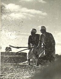
 Farmers near Bayt Jirja threshing wheat in 1940 | |
| أصل الاسم: The house of the highway[1] | |
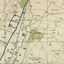
A series of historical maps of the area around Bayt Jirja (click the buttons) | |
Location within Mandatory Palestine | |
| الإحداثيات: 31°36′11″N 34°34′51″E / 31.60306°N 34.58083°E | |
| Palestine grid | 110/112 |
| Geopolitical entity | Mandatory Palestine |
| Subdistrict | Gaza |
| Date of depopulation | date unknown,[4] |
| المساحة | |
| • الإجمالي | 8,015 dunams (8٫015 كم² or 3٫095 ميل²) |
| التعداد (1945) | |
| • الإجمالي | 940[2][3] |
| Current Localities | None |
بيت جرجا قرية فلسطينية قديمة ،
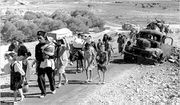
وهي من القرى المدمرة بعد حرب 1948 حيث تم تهجير سكانها منها بعد إنشاء دولة إسرائيل.
وينسب اليها أبو الفضل العباس بن محمد بن الحسن بن قتيبة العسقلاني الجرجي، من رواة الحديث، عرف باسم محدث فلسطين وتوفي عام 315هـ. وتقع إلى الشمال الشرقي من مدينة غزة ، وتبعد عنها 15.5 كم، وترتفع 50م عن سطح البحر. تبلغ مساحة اراضيها 8481 دونما، تحيط بأراضيها أراضي قرى سمسم، والجية، ودير سنيد، وبربرة، وهربيا. وقدر عدد سكانها عام 1922 حوالى (397) نسمة. وفي عام 1945 (940) نسمة. يوجد بالقرية جامع يرجع تاريخه إلى 1835م، انشئت بالقرية مدرسة عام 1932، ومن المواقع الاثرية خربة بير شقير، وخربة مورة، وخربة حربية. قامت المنظمات الصهيونية المسلحة بهدم القرية وتشريد اهلها البالغ عددهم عام 48 (1090) نسمة، وكان ذلك في 30/ 10/ 1948 ويبلغ مجموع اللاجئين من هذه القرية في عام 1998 (6696) نسمة. واقاموا على اراضيها مستعمرات (تالمي يافي)، (جيه)و(مافقعيم
وينتمي لهذه القرية حوالي 32 عائلة فلسطينية تقطن الآن أنحاء مختلفة من قطاع غزة ، ومن أبرز عائلات القرية :الجرجاوي , أبو ندى ، ماضي ، نجم ، أبو حلبية ، السادة ال الحلو ولهم اقارب في غزة والكرك ، أبو حسنين ، قاسم ، موسى ، أبو علبة.
التاريخ
انظر أيضاً
الهامش
- ^ Palmer, 1881, p. 365
- ^ Government of Palestine, Department of Statistics, 1945, p. 31 Archived 2020-04-14 at the Wayback Machine
- ^ أ ب Government of Palestine, Department of Statistics. Village Statistics, April, 1945. Quoted in Hadawi, 1970, p. 45
- ^ Morris, 2004, p. xix, village #312, gives both date and cause of depopulation as "Not known"
ببليوگرافيا
- Barron, J.B., ed. (1923). Palestine: Report and General Abstracts of the Census of 1922. Government of Palestine.
- Conder, C.R.; Kitchener, H.H. (1883). The Survey of Western Palestine: Memoirs of the Topography, Orography, Hydrography, and Archaeology. Vol. 3. London: Committee of the Palestine Exploration Fund.
- Government of Palestine, Department of Statistics (1945). Village Statistics, April, 1945.
- Guérin, V. (1869). Description Géographique Historique et Archéologique de la Palestine. Vol. 1: Judee, pt. 2. Paris, L'Imprimerie Imp.
- Hadawi, S. (1970). Village Statistics of 1945: A Classification of Land and Area ownership in Palestine. Palestine Liberation Organization Research Center.
- Hartmann, M. (1883). "Die Ortschaftenliste des Liwa Jerusalem in dem türkischen Staatskalender für Syrien auf das Jahr 1288 der Flucht (1871)". Zeitschrift des Deutschen Palästina-Vereins. 6: 102–149.
- Hütteroth, Wolf-Dieter; Abdulfattah, Kamal (1977). Historical Geography of Palestine, Transjordan and Southern Syria in the Late 16th Century. Erlanger Geographische Arbeiten, Sonderband 5. Erlangen, Germany: Vorstand der Fränkischen Geographischen Gesellschaft. ISBN 3-920405-41-2.
- Khalidi, W. (1992). All That Remains: The Palestinian Villages Occupied and Depopulated by Israel in 1948. Washington, D.C.: Institute for Palestine Studies. ISBN 0-88728-224-5.
- Mills, E, ed. (1932). Census of Palestine 1931. Population of Villages, Towns and Administrative Areas. Jerusalem: Government of Palestine.
- Morris, B. (2004). The Birth of the Palestinian Refugee Problem Revisited. Cambridge: Cambridge University Press. ISBN 978-0-521-00967-6.
- Nahshoni, Pirhiya (10 September 2008). "Khirbat 'Amuda" (120). Hadashot Arkheologiyot – Excavations and Surveys in Israel.
{{cite journal}}: Cite journal requires|journal=(help) - Palmer, E.H. (1881). The Survey of Western Palestine: Arabic and English Name Lists Collected During the Survey by Lieutenants Conder and Kitchener, R. E. Transliterated and Explained by E.H. Palmer. Committee of the Palestine Exploration Fund.
- Robinson, E.; Smith, E. (1841). Biblical Researches in Palestine, Mount Sinai and Arabia Petraea: A Journal of Travels in the year 1838. Vol. 3. Boston: Crocker & Brewster.
- Sharon, M. (1999). Corpus Inscriptionum Arabicarum Palaestinae, B-C. Vol. 2. BRILL. ISBN 90-04-11083-6.
- Socin, A. (1879). "Alphabetisches Verzeichniss von Ortschaften des Paschalik Jerusalem". Zeitschrift des Deutschen Palästina-Vereins. 2: 135–163.
وصلات خارجية
- "Welcome to Bayt Jirja". Palestine Remembered.
- "Bayt Jirja". Zochrot.
- Survey of Western Palestine, Map 20: Israeli Antiquities Aurhority, Wikimedia Commons
- "Palestinians: profile of a people in search of statehood". The Observer. Guardian Media Group. 17 September 2011. (Abu Ahmed, Gaza city, a descendant of Bayt Jirja refugees)
خطأ لوا في وحدة:Authority_control على السطر 278: attempt to call field '_showMessage' (a nil value).


