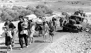
قديتا
Qaddita
قدّيتا Kaditta | |
|---|---|
Village | |
| أصل الاسم: from personal name[1] | |
| الإحداثيات: 33°00′20″N 35°28′01″E / 33.00556°N 35.46694°E | |
| Palestine grid | 194/267 |
| Geopolitical entity | Mandatory Palestine |
| Subdistrict | Safad |
| Date of depopulation | May 11, 1948[4] |
| المساحة | |
| • الإجمالي | 2,441 dunams (2٫441 كم² or 603 acres) |
| التعداد (1945) | |
| • الإجمالي | 240[2][3] |
| Cause(s) of depopulation | Influence of nearby town's fall |
| Current Localities | Kadita |
قديتا هي قرية فلسطينية مهجرة كانت موجودة غرب مدينة صفد.
كانت القرية تبعد حوالي 4.5 كم عن صفد، وكان عدد سكانها 240 سنة 1944. تم احتلال القرية وتهجيرها بتاريخ 9-11 أيار سنة 1948 على يد قوات الهاگاناه الصهيونية.[5]
اليوم لم يتبق من القرية إلا بعض القبور من مقبرة القرية، وكذلك آثار بيوت مهدمة. كذلك مستعمرتا صفصوفة، المبنية على أراضي قرية الصفصاف المهجرة، ودالتون تقعان بالقرب من أراضي قرية قديتا.
انظر أيضاً
مراجع
ببليوگرافيا
- Barron, J. B., ed. (1923). Palestine: Report and General Abstracts of the Census of 1922. Government of Palestine.
- Conder, C.R.; Kitchener, H.H. (1881). The Survey of Western Palestine: Memoirs of the Topography, Orography, Hydrography, and Archaeology. Vol. 1. London: Committee of the Palestine Exploration Fund.
- Department of Statistics (1945). Village Statistics, April, 1945. Government of Palestine.
- Guérin, V. (1880). Description Géographique Historique et Archéologique de la Palestine (in French). Vol. 3: Galilee, pt. 2. Paris: L'Imprimerie Nationale.
{{cite book}}: CS1 maint: unrecognized language (link) - Hadawi, S. (1970). Village Statistics of 1945: A Classification of Land and Area ownership in Palestine. Palestine Liberation Organization Research Centre.
- Hütteroth, Wolf-Dieter; Abdulfattah, Kamal (1977). Historical Geography of Palestine, Transjordan and Southern Syria in the Late 16th Century. Erlanger Geographische Arbeiten, Sonderband 5. Erlangen, Germany: Vorstand der Fränkischen Geographischen Gesellschaft. ISBN 3-920405-41-2.
- Karmon, Y. (1960). "An Analysis of Jacotin's Map of Palestine" (PDF). Israel Exploration Journal. 10 (3, 4): 155–173, 244–253.
- Khalidi, W. (1992). All That Remains: The Palestinian Villages Occupied and Depopulated by Israel in 1948. Washington D.C.: Institute for Palestine Studies. ISBN 0-88728-224-5.
- Mills, E., ed. (1932). Census of Palestine 1931. Population of Villages, Towns and Administrative Areas. Jerusalem: Government of Palestine.
- Morris, B. (2004). The Birth of the Palestinian Refugee Problem Revisited. Cambridge University Press. ISBN 978-0-521-00967-6.
- Palmer, E. H. (1881). The Survey of Western Palestine: Arabic and English Name Lists Collected During the Survey by Lieutenants Conder and Kitchener, R. E. Transliterated and Explained by E.H. Palmer. Committee of the Palestine Exploration Fund.
- Robinson, E.; Smith, E. (1841). Biblical Researches in Palestine, Mount Sinai and Arabia Petraea: A Journal of Travels in the year 1838. Vol. 3. Boston: Crocker & Brewster.
- Rhode, H. (1979). Administration and Population of the Sancak of Safed in the Sixteenth Century. Columbia University.
- Schumacher, G. (1888). "Population list of the Liwa of Akka". Quarterly statement - Palestine Exploration Fund. 20: 169–191.
وصلات خارجية
- قديتا ترحب بكم
- Qaddita, Zochrot
- Survey of Western Palestine, Map 4: IAA, Wikimedia commons
- Qaddita, from the Khalil Sakakini Cultural Center
- Qaddita, Dr. Khalil Rizk
This article may include material from Wikimedia licensed under CC BY-SA 4.0. Please comply with the license terms.

