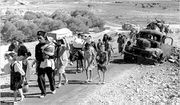
هوج
| Huj | ||
| ||
|
خطأ لوا في وحدة:Location_map على السطر 391: A hemisphere was provided for longitude without degrees also being provided. |
||
| بالعربية | هوج | |
| معنى الاسم | Possibly named after the prophet Og[1] | |
| تهجيات أخرى | al-Hug | |
| المقاطعات | غزة | |
| التعداد | 1,040[2][3] (1945) | |
| المساحة | 21,988 dunums
22.9 km² | |
| تاريخ التهجير | May 31, 1948[4] | |
| أسباب التهجير | طردتهم القوات الإسرائيلية | |
| المواضع الحالية | Dorot[5] | |
هوج هي قرية عربية على مسافة 18 كيلاً شرق غزة, وقامت في موقع قرية أوغا في العهد الروماني, ثم تعرضت للتخريب, وأعيد بناؤها في النصف الأول من القرن 19 في عهد مصطفى بيك أحد حكام غزة, وقد وزع أراضي القرية بلا ثمن على من يرغب من أهالي غزة في الإقامة فيها وتعميرها, وأقام فيها مخفراً فشجع الناس في سكناها, وكان أول من سكنها عائلة النجار من الشجاعية, وبلغ عدد سكانها عام 1945 حوالي 810 نسمة، هدمها اليهود سنة 1948. وأقاموا مستعمرة دوروت ومستعمرة جيفيم.
ولعل هذه القرية سميت باسم هوج ملك طبريا الذي أخذه السلطان صلاح الدين الأيوبي أسيراً سنة 1179م, وقبل أن يطلق سراحه اقترح عليه أن يعلمه الإفرنج في خلق الفرسان, فجرب هوج أن يتملص ولكن صلاح الدين أصر على طلبه فشرع في تمثيل الاحتفال والتذ صلاح الدين بما شاهده, وكان يستوضح عن معنى كل حركة, ولما انتهى هوج سأله الدين هل بقي شيء, فأجابه نعم يا سيدي ولكن لا أجسر على تمثيله, وذلك هو العناق.
وبالقرب منها خربة تل جمه, وكانت قديماً عاصمة أبيمالك ملك الفلسطينيين, وتعرف بجرار ثم هاجمها الخراب وصارت في القرون الوسطى من أوقاف عرب السوالمة, ثم تملكها الناس وتصرفوا فيها,وكذلك خربة الكوفخة والمحرقة.
انظر أيضاً
المصادر
الهامش
ببليوجرافيا
- Barron, J. B., ed. (1923). Palestine: Report and General Abstracts of the Census of 1922. Government of Palestine.
- Conder, Claude Reignier; Kitchener, H. H. (1883). The Survey of Western Palestine: Memoirs of the Topography, Orography, Hydrography, and Archaeology. Vol. 3. London: Committee of the Palestine Exploration Fund.
- Department of Statistics (1945). Village Statistics, April, 1945. Government of Palestine.
- Guérin, Victor (1869). Description Géographique Historique et Archéologique de la Palestine (in French). Vol. 1: Judee, pt. 2. Paris: L'Imprimerie Nationale.
{{cite book}}: CS1 maint: unrecognized language (link) - Hadawi, Sami (1970). Village Statistics of 1945: A Classification of Land and Area ownership in Palestine. Palestine Liberation Organization Research Center.
- Hartmann, M. (1883). "Die Ortschaftenliste des Liwa Jerusalem in dem türkischen Staatskalender für Syrien auf das Jahr 1288 der Flucht (1871)". Zeitschrift des Deutschen Palästina-Vereins. 6: 102–149.
- Khalidi, Walid (1992). All That Remains: The Palestinian Villages Occupied and Depopulated by Israel in 1948. Washington D.C.: Institute for Palestine Studies. ISBN 0-88728-224-5.
- Mills, E., ed. (1932). Census of Palestine 1931. Population of Villages, Towns and Administrative Areas. Jerusalem: Government of Palestine.
- Morris, Benny (2004). The Birth of the Palestinian Refugee Problem Revisited. Cambridge University Press. ISBN 978-0-521-00967-6.
- Palmer, E. H. (1881). The Survey of Western Palestine: Arabic and English Name Lists Collected During the Survey by Lieutenants Conder and Kitchener, R. E. Transliterated and Explained by E.H. Palmer. Committee of the Palestine Exploration Fund.
- Robinson, Edward; Smith, Eli (1841). Biblical Researches in Palestine, Mount Sinai and Arabia Petraea: A Journal of Travels in the year 1838. Vol. 2. Boston: Crocker & Brewster.
- Socin, A. (1879). "Alphabetisches Verzeichniss von Ortschaften des Paschalik Jerusalem". Zeitschrift des Deutschen Palästina-Vereins. 2: 135–163.
وصلات خارجية
- Welcome to Huj, Palestineremembered.com
- Huj, Zochrot
- Survey of Western Palestine, Map 20: IAA, Wikimedia commons
- Huj from the Khalil Sakakini Cultural Center

