المحيط الجنوبي


| محيطات العالم |
|---|
|
تقسيمات المحيطات الخمسة: تقسيمات أخرى: البحار الهامشية |


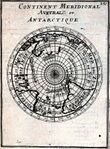
المحيط الجنوبي (Southern Ocean)، يُعرف أيضاً باسم محيط أنتاركتيكا (Antarctic Ocean،[1][note 4]، يضم مياه المحيط العالمي الواقعة في أقصى الجنوب، والتي يُعتقد عمومًا أنها تقع جنوب خط العرض 60° جنوباً ويحيط بالقارة القطبية الجنوبية (أنتاركتيكا).[5] بمساحة تبلغ 20.327.000 كم²، يعتبر المحيط الجنوبي ثاني أصغر الأقسام المحيطات الرئيسية الخمسة، وأصغر من المحيط الهادي، الأطلسي، والهندي، وأكبر من المحيط المتجمد الشمالي.[6]
في أوائل فبراير 2019 قامت بعثة الأعماق الخمسة بمسح أقصى عمق للمحيط الجنوبي، باستخدام التعريف القائل بأنه يقع جنوب خط العرض 60. حدد فريق السونار متعدد الحزم التابع للبعثة أعمق نقطة عند 60° 28' 46"جنوباً، 025° 32' 32"غرباً، بعمق 7434 مترًا. اقترح قائد البعثة ورئيس ملاحي الغواصة ڤكتور ڤسكوڤو تسمية هذه النقطة الأعمق "عمق فاكتوريان" (Factorian Deep)، استنادًا إلى اسم الغواصة المأهولة لمتنگ فاكتور، والتي زار فيها القاع بنجاح لأول مرة في 3 فبراير 2019.[7]
من خلال رحلاته في ع. 1770، أثبت جيمس كوك أن المياه تشمل خطوط العرض الجنوبية للعالم. ومع ذلك، اختلف الجغرافيون غالبًا حول ما إذا كان ينبغي تعريف المحيط الجنوبي باعتباره كتلة من المياه يحدها التقارب القطبي الجنوبي المتقلب موسميًا - وهو نطاق محيطي حيث تمتزج المياه الباردة المتدفقة شمالاً من القطب الجنوبي بمياه صب أنتاركتيكا الدافئة،[8] أو لم يُعرف على الإطلاق، حيث يتم التعامل مع مياهه بدلاً من ذلك باعتبارها الحدود الجنوبية للمحيط الهادي والأطلسي والهندي. وقد حسمت المنظمة الهيدروغرافية الدولية المناقشة أخيرًا بعد التأكد من الأهمية الكاملة لدورة انقلاب المحيط الجنوبي، والآن يحدد مصطلح المحيط الجنوبي المسطح المائي الذي يقع جنوب الحد الشمالي لتلك الدورة.[9]
تعتبر دورة انقلاب المحيط الجنوبي هامة لأنها تشكل النصف الثاني من الدورة الحرارية الملحية العالمية، بعد دورة انقلاب المحيط الأطلسي الأكثر شهرة.[10] تمامًا مثل دورة انقلاب المحيط الأطلسي، فقد تأثرت أيضًا بشكل كبير بتغير المناخ، بطرق أدت إلى زيادة تطبق المحيط،[11] وقد يؤدي هذا أيضًا إلى تباطؤ الدورة بشكل كبير أو حتى تجاوز نقطة التحول والانهيار التام. ومن شأن هذا الأخير أن يخلف آثار سلبية على الطقس العالمي ووظيفة النظم البيئية البحرية هنا، والتي تتكشف على مدى قرون.[12][13] إن ظاهرة الاحتباس الحراري المستمرة تغير بالفعل النظم البيئية البحرية هناك.[14]
. . . . . . . . . . . . . . . . . . . . . . . . . . . . . . . . . . . . . . . . . . . . . . . . . . . . . . . . . . . . . . . . . . . . . . . . . . . . . . . . . . . . . . . . . . . . . . . . . . . . . . . . . . . . . . . . . . . . . . . . . . . . . . . . . . . . . . . . . . . . . . . . . . . . . . . . . . . . . . . . . . . . . . . .
التعريف واستخدام المصطلح

تم الاتفاق على حدود وأسماء المحيطات والبحار دوليًا عندما عقد المكتب الهيدروغرافي الدولي، السلف للمنظمة الهيدروغرافية الدولية، المؤتمر الدولي الأول في 24 يوليو 1919. ثم نشرت المنظمة الهيدروغرافية الدولية هذه الحدود في حدود المحيطات والبحار، وكانت الطبعة الأولى عام 1928. ومنذ الطبعة الأولى، تحركت حدود المحيط الجنوبي تدريجيًا نحو الجنوب؛ ومنذ عام 1953، وحُذفت من النشر الرسمي وتركت للمكاتب الهيدروغرافية المحلية لتحديد حدودها الخاصة.
أدرجت المنظمة الهيدروغرافية الدولية المحيط وتعريفه باعتباره المياه الواقعة جنوب خط العرض 60° جنوباً في مراجعاتها لعام 2000، لكن لم يُعتمد هذا رسميًا، بسبب استمرار الجمود حول بعض المحتوى، مثل نزاع تسمية بحر اليابان. تم تداول تعريف المنظمة الهيدروغرافية الدولية لعام 2000 كإصدار مسودة عام 2002، ويستخدمه البعض داخل المنظمة الهيدروغرافية الدولية ومنظمات أخرى، مثل كتاب حقائق العالم سي آي إيه ومريام-وبستر.[6][15]
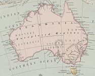
تعتبر الحكومة الأسترالية أن المحيط الجنوبي يقع جنوب أسترالياً مباشرة (انظر
اعترفت الجمعية الجغرافية الوطنية بالمحيط رسميًا في يونيو 2021.[18][19] قبل ذلك، كانت تصوره بخط مختلف عن محيطات العالم الأخرى؛ وبدلاً من ذلك، تظهر المحيط الهادي والأطلسي والهندي ممتدين إلى القارة القطبية الجنوبية على خرائطها المطبوعة وعبر الإنترنت.[20][21] من بين ناشري الخرائط الذين يستخدمون مصطلح المحيط الجنوبي على خرائطهم خرائط هـِما[22] وجيونوڤا.[23]
ما قبل القرن 20
.jpg&filetimestamp=20240714211405&)
"المحيط الجنوبي" هو الاسم القديم الزمن للمحيط الهادي أو جنوب المحيط الهادي، صاغه المستكشف الإسڤاني ڤاسكو نونيز ده بالبوا، أول أوروپي يكتشف المحيط الهادي، والذي اقترب منه من الشمال عند پنما.[24] "البحار الجنوبية" هو مرادف أقل قدماً. أقر قانون البرلمان البريطاني لعام 1745 جائزة لاكتشاف ممر شمالي جنوبي يؤدي إلى "المحيط الغربي والمحيط الجنوبي لأمريكا".[25]
استخدم المؤلفون مصطلح "المحيط الجنوبي" لتسمية المياه المحيطة بالمناطق القطبية الجنوبية الغير معروفة، واستخدموا حدودًا مختلفة. وتشير رواية جيمس كوك عن رحلته الثانية إلى أن كاليدونيا الجديدة تقع على حدودها.[26] ذكر القاموس الجغرافي لپيكوك 1795 أن هذه المياه تقع "إلى الجنوب من أمريكا وأفريقيا"؛[27] في عام 1796 استخدم جون پاين 40 درجة كحد شمالي؛[28] واستخدمت ادنبره گازيتر 1827 50 درجة.[29] عام 1835، قسمت فاميلي ماگازين "المحيط الجنوبي العظيم" إلى "المحيط الجنوبي" و"محيط أنتاركتيكا" على امتداد الدائرة القطبية الجنوبية، مع كون الحد الشمالي للمحيط الجنوبي عبارة عن خطوط تربط بين كيپ هورن ورأس الرجاء الصالح وأرض ڤان دايمن وجنوب نيوزيلندا.[30]
وصف قانون أستراليا الجنوبية 1834 الصادر عن المملكة المتحدة المياه التي تشكل الحد الجنوبي لمقاطعة أستراليا الجنوبية الجديدة بأنها "المحيط الجنوبي". كما حدد قانون المجلس التشريعي لعام 1881 الصادر عن مستعمرة ڤيكتوريا جزءًا من تقسيم بايرنسديل بأنه "على امتداد حدود نيوساوث ويلز إلى المحيط الجنوبي".[31]
ترسيم 1928

في الطبعة الأولى لعام 1928 من حدود المحيطات والبحار، تم ترسيم حدود المحيط الجنوبي من خلال الحدود البرية: القارة القطبية الجنوبية إلى الجنوب، وأمريكا الجنوبية، وأفريقيا، وأستراليا، وجزيرة بروتون، نيوزيلندا إلى الشمال.
كانت حدود الأراضي التفصيلية المستخدمة من كيپ هورن في تشيلي شرقًا إلى كيپ أگولاس في أفريقيا، ثم شرقًا إلى الساحل الجنوبي لأستراليا البرية إلى كيپ ليوين، أستراليا الغربية. ومن كيپ ليوين، تبع الحد شرقًا على امتداد ساحل أستراليا البرية إلى كيپ أوتواي، ڤيكتوريا، ثم جنوبًا عبر مضيق باس إلى كيپ ويكهام، جزيرة كنگ، على امتداد الساحل الغربي لجزيرة كنگ، ثم بقية الطريق جنوبًا عبر مضيق باس إلى كيپ گريم، تازمانيا.
ثم تبع الحد الساحل الغربي لتازمانيا جنوبًا إلى كيپ ساوث إيست ثم شرقًا إلى جزيرة بروتون بنيوزيلندا، قبل العودة إلى كيپ هورن.[32]
ترسيم 1937

نثقلت الحدود الشمالية للمحيط الجنوبي جنوبًا في الطبعة الثانية لعام 1937 من حدود المحيطات والبحار التي أصدرتها المنظمة الهيدروغرافية الدولية. ومنذ هذه الطبعة، لم يعد جزء كبير من الحد الشمالي للمحيط يلامس كتل اليابسة.
في الطبعة الثانية، امتد المحيط الجنوبي من القارة القطبية الجنوبية شمالاً إلى خط العرض 40° جنوبًا بين كيپ أگولاس في أفريقيا (خط الطول 20° شرقًا) وكيپ ليوين في أستراليا الغربية (خط الطول 115° شرقًا)، وامتد إلى خط العرض 55° جنوبًا بين جزيرة أوكلاند في نيوزيلندا (165 أو 166° شرقًا) وكيپ هورن في أمريكا الجنوبية (67° غربًا).[33]
كما تمت مناقشته بمزيد من التفصيل أدناه، قبل إصدار عام 2002، كانت حدود المحيطات تستبعد صراحة البحار الواقعة داخل كل منها. لم يُسمى الخليج الأسترالي العظيم في طبعة عام 1928، وتم تحديده كما هو موضح في الشكل أعلاه في طبعة عام 1937. وبالتالي، فقد شمل مياه المحيط الجنوبي السابقة - كما تم تحديدها عام 1928 - لكنه لم يكن من الناحية التقنية داخل أي من المحيطات الثلاثة المجاورة بحلول عام 1937.
في مسودة عام 2002، صنفت المنظمة الهيدروغرافية الدولية "البحار" باعتبارها أقساماً فرعية داخل "المحيطات"، وبالتالي فإن الخليج كان ليظل ضمن المحيط الجنوبي عام 1937 إذا كانت اتفاقية عام 2002 سارية آنذاك. ولإجراء مقارنات مباشرة بين الحدود الحالية والسابقة للمحيطات، من الضروري أن نأخذ في الاعتبار، أو على الأقل أن ندرك، كيف يمكن للتغيير الذي حدث عام 2002 في مصطلحات المنظمة الهيدروغرافية الدولية لـ"البحار" أن يؤثر على المقارنة.
ترسيم 1953
لم يظهر المحيط الجنوبي في الطبعة الثالثة لعام 1953 من حدود المحيطات والبحار، وجاء في ملاحظة بالمنشور:
لقد حُذف المحيط الجنوبي أو محيط أنتاركتيكا من هذا المنشور لأن أغلب الآراء الواردة منذ إصدار الطبعة الثانية عام 1937 تشير إلى عدم وجود مبرر حقيقي لتطبيق مصطلح المحيط على هذا المسطح المائي، والذي يصعب تحديد حدوده الشمالية بسبب تغير الفصول. وبالتالي تم تمديد حدود المحيط الأطلسي والهادي والهندي جنوبًا إلى القارة القطبية الجنوبية.
وبناءً على ذلك، يتعين على المكاتب الهيدروغرافية التي تصدر منشورات منفصلة تتناول هذه المنطقة أن تقرر حدودها الشمالية بنفسها (تستخدم بريطانيا العظمى خط عرض 55 درجة جنوبًا).[34]
بدلاً من ذلك، في إصدار المنظمة الهيدروغرافية الدولية لعام 1953، تم تمديد المحيط الأطلسي والهندي والهادي جنوبًا، وأصبح المحيطان الهندي والهادي (اللذان لم يلمسا بعضهما البعض قبل عام 1953، وفقًا للطبعتين الأولى والثانية) الآن متاخمين لخط زوال رأس الرجاء الصالح، ونُقلت الحدود الجنوبية للخليج الأسترالي العظيم وبحر تاسمان شمالًا.[34]
مسودة ترسيم 2002

أعادت المنظمة الهيدروغرافية الدولية تناول مسألة المحيط الجنوبي في استطلاع أجرته عام 2000. ومن بين الدول الأعضاء البالغ عددها 68 دولة، استجابت 28 دولة، ووافق جميع الأعضاء المستجيبين باستثناء الأرجنتين على إعادة تعريف المحيط، بما يعكس الأهمية التي يوليها علماء المحيطات للتيارات المحيطية. فاز اقتراح تسمية "المحيط الجنوبي" بـ 18 صوتًا، متغلبًا على البديل "المحيط القطبي الجنوبي". أيد نصف الأصوات تعريف الحد الشمالي للمحيط عند خط العرض 60° جنوباً - دون انقطاعات برية عند هذا العرض - مع الإدلاء بـ 14 صوتًا أخرى لتعريفات أخرى، معظمها خط العرض 50° جنوباً، لكن القليل منها في أقصى الشمال حتى خط العرض 35° جنوباً. والجدير بالذكر أن نظام مراقبة المحيط الجنوبي يجمع البيانات من خطوط العرض الأعلى من 40° جنوباً.
في أغسطس 2002 تم توزيع مسودة الطبعة الرابعة من "حدود المحيطات والبحار" على الدول الأعضاء في المنظمة الهيدروغرافية الدولية (يشار إليها أحياناً باسم "طبعة عام 2000" لأنها تلخص التقدم المحرز حتى عام 2000).[36] لم تُنشر الطبعة الرابعة بعد بسبب "جوانب القلق" التي أثارتها العديد من البلدان فيما يتعلق بقضايا التسمية المختلفة في جميع أنحاء العالم - وفي المقام الأول نزاع تسمية بحر اليابان - وكانت هناك تغييرات مختلفة، وتم إعطاء 60 بحرًا أسماء جديدة، وحتى اسم النشر تم تغييره.[37] كما قدمت أستراليا تحفظًا بشأن حدود المحيط الجنوبي.[38] في الواقع، فإن الطبعة الثالثة ــ التي لم تحدد المحيط الجنوبي وتركت تحديده للمكاتب الهيدروغرافية المحلية ــ لم يتم استبدالها بعد.

على الرغم من هذا، فإن تعريف الطبعة الرابعة يُستخدم جزئياً بحكم الأمر الواقع من قبل العديد من الدول والعلماء والمنظمات مثل الولايات المتحدة (يستخدم كتاب حقائق العالم الصادر عن سي آي إيه "المحيط الجنوبي"، ولكن لا يوجد أي من أسماء البحار الجديدة الأخرى ضمن "المحيط الجنوبي"، مثل "بحر كوزموناتس") وقاموس مريام-وبستر،[6][15][21] scientists and nations – and even by some within the IHO.[39] حددت بعض المكاتب الهيدروغرافية للدول حدودها الخاصة؛ استخدمت المملكة المتحدة خط العرض 55° جنوباً على سبيل المثال.[34] وتفضل منظمات أخرى حدودًا أكثر شمالية للمحيط الجنوبي. على سبيل المثال، تصف الموسوعة البريطانية المحيط الجنوبي بأنه يمتد إلى أقصى الشمال حتى أمريكا الجنوبية، وتمنح أهمية كبيرة التقارب القطبي الجنوبي، إلا أن وصفها للمحيط الهندي يتناقض مع هذا، حيث تصف المحيط الهندي بأنه يمتد جنوبًا إلى القارة القطبية الجنوبية.[40][41]
تُظهر مصادر أخرى، مثل الجمعية الجغرافية الوطنية، أن المحيط الأطلسي والهادي والهندي تمتد إلى القارة القطبية الجنوبية على خرائطها، على الرغم من أن المقالات على موقع ناشيونال جيوگرافيك الإلكتروني بدأت في الإشارة إلى المحيط الجنوبي.[21]
ولقد لوحظ تحولاً جذرياً عن ممارسات المنظمة الهيدروغرافية الدولية السابقة (1928-1953) في مسودة طبعة عام 2002 عندما حددت المنظمة "البحار" باعتبارها أقساماً فرعية داخل حدود "المحيطات". وفي حين تُعَد المنظمة الهيدروغرافية الدولية غالباً هي السلطة المخولة بوضع مثل هذه الاتفاقيات، فإن هذا التحول جعلها متوافقة مع ممارسات منشورات أخرى (على سبيل المثال كتاب حقائق العالم) التي تبنت بالفعل مبدأ احتواء البحار داخل المحيطات. ويتجلى هذا الاختلاف في الممارسة بشكل واضح في "المحيط الهادي" في الشكل المجاور. وعلى سبيل المثال، لم تكن المنظمة الهيدروغرافية الدولية تعتبر في السابق بحر تاسمان الواقع بين أستراليا ونيوزيلندا جزءاً من المحيط الهادي، ولكن اعتباراً من مسودة طبعة عام 2002 أصبح الأمر كذلك.
لقد تجنب الترسيم الجديد للبحار باعتبارها أقسامًا فرعية للمحيطات الحاجة إلى مقاطعة الحدود الشمالية للمحيط الجنوبي حيث يتقاطع مع ممر دريك الذي يشمل جميع المياه من أمريكا الجنوبية إلى ساحل القارة القطبية الجنوبية، ولا مقاطعته بالنسبة لبحر سكوتشيا، والذي يمتد أيضًا إلى ما دون خط العرض 60° جنوباً. كما يعني الترسيم الجديد للبحار أن البحار التي سُميت منذ فترة طويلة حول القارة القطبية الجنوبية، والتي تم استبعادها من طبعة عام 1953 (لم تمتد خريطة عام 1953 حتى ذلك الحد الجنوبي)، هي تلقائيًا جزء من المحيط الجنوبي.

. . . . . . . . . . . . . . . . . . . . . . . . . . . . . . . . . . . . . . . . . . . . . . . . . . . . . . . . . . . . . . . . . . . . . . . . . . . . . . . . . . . . . . . . . . . . . . . . . . . . . . . . . . . . . . . . . . . . . . . . . . . . . . . . . . . . . . . . . . . . . . . . . . . . . . . . . . . . . . . . . . . . . . . .
وجه النظر الأسترالية
في أستراليا، تحدد السلطات المختصة برسم الخرائط المحيط الجنوبي على أنه يشمل كامل المسطح المائي الواقع بين القارة القطبية الجنوبية والسواحل الجنوبية لأستراليا ونيوزيلندا، وحتى 60 درجة جنوبًا في أماكن أخرى.[42] تُشير الخرائط الساحلية لتسمانيا وجنوب أستراليا إلى المناطق البحرية باسم المحيط الجنوبي[43] ويُوصف كيپ ليوين في غرب أستراليا بأنه النقطة التي يلتقي فيها المحيط الهندي والمحيط الجنوبي.[44]
تاريخ الاستكشاف
الأرض الجنوبية المجهولة

كان استكشاف المحيط الجنوبي مستوحى من الاعتقاد بوجود تيرا أستراليس - قارة شاسعة في أقصى جنوب الكرة الأرضية "لموازنة" الأراضي الشمالية في أوراسيا وشمال أفريقيا - والتي كانت موجودة منذ زمن پطليموس. كان الدوران حول رأس الرجاء الصالح عام 1487 بواسطة بارثولوميو دياز أول من جعل المستكشفين على اتصال ببرودة القارة القطبية الجنوبية، وأثبت وجود محيط يفصل أفريقيا عن أي أرض قد تُوجد في القارة القطبية الجنوبية.[45] افترض فريدناند ماجلان، الذي عبر مضيق ماجلان عام 1520، أن جزر تييرا دل فويگو إلى الجنوب كانت امتدادًا لهذه الأرض الجنوبية المجهولة. عام 1564، نشر أبراهام أورتليوس أول خريطة له، Typus Orbis Terrarum، وهي خريطة حائطية مكونة من ثماني أوراق للعالم، حدد فيها Regio Patalis مع Locach كامتداد شمالي لتيرا أستراليس، ويمتد إلى غينيا الجديدة.[46][47]
استمر الجغرافيون الأوروپيون في ربط ساحل تييرا دل فويگو بساحل غينيا الجديدة على كراتهم الأرضية، وأطلقوا العنان لخيالهم في المساحات الشاسعة غير المعروفة في جنوب المحيط الأطلسي وجنوب المحيط الهندي والمحيط الهادي، فرسموا الخطوط العريضة لـ ""Terra Australis Incognita"" (""الأرض الجنوبية المجهولة"")، وهي قارة شاسعة تمتد في أجزاء إلى المناطق الاستوائية. كان البحث عن هذه الأرض الجنوبية العظيمة دافعًا رئيسيًا للمستكشفين في القرن السادس عشر والجزء الأول من القرن السابع عشر.[45]
يُعتبر الإسپاني گابرييل دي كاستيا، الذي ادعى أنه رأى "جبالاً مغطاة بالثلوج" وراء 64° جنوباً عام 1603، أول مستكشف اكتشف قارة أنتاركتيكا، على الرغم من تجاهله في عصره.
عام 1606، استولى پدرو فرنانديز دي كويروس على حيازة ملك إسپانيا لجميع الأراضي التي اكتشفها في أستراليا، دل إسپيريتو سانتو (نيو هبريدز) وتلك التي سيكتشفها "حتى القطب الشمالي".[45]
كان فرانسيس دريك، مثل المستكشفين الإسپان من قبله، قد تكهن بوجود قناة مفتوحة جنوب تييرا دل فويگو. وعندما اكتشف ڤيلم شوتن وجاكوب لو مير الطرف الجنوبي من تييرا دل فويگو وأطلقا عليه اسم كيپ هورن عام 1615، أثبتا أن أرخبيل تييرا دل فويگو كان صغير المساحة وغير متصل بالأرض الجنوبية، كما كان يُعتقد سابقًا. وفي وقت لاحق، عام 1642، أظهر أبل تازمان أنه حتى هولندا الجديدة (أستراليا) كانت منفصلة عن أي قارة جنوبية متصلة بالبحر.[45]
جنوب التقارب القطبي الجنوبي

كانت زيارة جورجيا الجنوبية التي قام بها أنتوني دي لا روشي عام 1675 هي أول اكتشاف على الإطلاق للأرض الواقعة جنوب التقارب القطب الجنوبي، أي في المحيط الجنوبي/القطب الجنوبي.[48][49] بعد فترة وجيزة من الرحلة، بدأ رسامو الخرائط في تصوير "جزيرة روشي"، تكريمًا للمكتشف. كان جيمس كوك على علم باكتشاف لا روشي عندما قام بمسح الجزيرة ورسم خرائطها عام 1775.[50]
التقت رحلة إدموند هالي على متن السفينة پارامور للدراسات المغناطيسية في جنوب المحيط الأطلسي بالجليد المتراكم عند خط العرض 52° جنوباً في يناير 1700، لكن خط العرض هذا (وصل إلى مسافة 230 كم قبالة الساحل الشمالي لجورجيا الجنوبية) كان أقصى امتداد جنوبي له. أسفرت الجهود الحثيثة التي بذلها الضابط البحري الفرنسي جان-باتيست شارل بوڤيه دى لوزييه لاكتشاف "أرض الجنوب" - التي وصفها "دي جونيفيل" نصف الأسطوري - عن اكتشاف جزيرة بوڤيه عند 54°10′ جنوباً، والإبحار على خط الطول 48° من البحر المغطى بالجليد عند خط العرض 55° جنوباً تقريباً عام 1730.[45]
عام 1771، أبحر إيڤ-جوزيف كرگيلن من فرنسا بناءً على تعليمات بالتوجه جنوبًا من موريشيوس بحثًا عن "قارة كبيرة جدًا". عثر على أرض عند 50° جنوباً، أطلق عليها اسم جنوب فرنسا، وكان يعتقد أنها الكتلة المركزية للقارة الجنوبية. أُرسل مرة أخرى لاستكمال استكشاف الأرض الجديدة، ووجد أنها مجرد جزيرة غير مضيافة أطلق عليها اسم جزيرة الخراب، لكنها في النهاية سُميت عل اسمه.[45]
. . . . . . . . . . . . . . . . . . . . . . . . . . . . . . . . . . . . . . . . . . . . . . . . . . . . . . . . . . . . . . . . . . . . . . . . . . . . . . . . . . . . . . . . . . . . . . . . . . . . . . . . . . . . . . . . . . . . . . . . . . . . . . . . . . . . . . . . . . . . . . . . . . . . . . . . . . . . . . . . . . . . . . . .
جنوب الدائرة القطبية الجنوبية


بلغ الهوس بالقارة غير المكتشفة ذروته في عقل ألكسندر دالريمپل، عالم المساحة البحرية اللامع الذي رشحته الجمعية الملكية لقيادة بعثة عبور كوكب الزهرة إلى تاهيتي عام 1769. وقد أسندت الأميرالية قيادة البعثة إلى الكابتن جيمس كوك. عام 1772، أبحر كوك على متن سفينة ريزولوشن، وهي سفينة تزن 462 طنًا تحت قيادته الخاصة، والسفينة أدڤنتشر التي تزن 336 طنًا تحت قيادة الكابتن توبياس فورنو، فبحث كوك أولاً دون جدوى عن جزيرة بوڤيه، ثم أبحر غرباً 20° في اتجاه خط الطول عند خط العرض 58° جنوباً، ثم 30° شرقاً في معظمها جنوب خط العرض 60° جنوباً، وهو خط عرض جنوبي أقل مما دخلته أي سفينة طواعية من قبل. في 17 يناير 1773، عبرت السفينتان الدائرة القطبية الجنوبية لأول مرة في التاريخ ووصلتا إلى تقاطع 67° 15' جنوباً مع 39° 35' شرقاً حيث توقف مسارهما بسبب الجليد.[45]

ثم اتجه كوك شمالاً للبحث عن الأراضي الفرنسية الجنوبية والقطبية، والتي تلقى أنباء عن اكتشافها في كيپ تاون، لكن من خلال التحديد التقريبي لخط الطول الخاص به بواسطة كرگيلن، وصل كوك إلى خط العرض المحدد 10° الواقع في أقصى الشرق ولم يرى ذلك الخط. اتجه جنوبًا مرة أخرى وتوقف بسبب الجليد عند تقاطع 61° 52′ جنوباً مع 95° شرقاً، واستمر شرقًا تقريبًا على خط مواز 60° جنوبًا إلى 147° شرقًا. في 16 مارس، دفعه الشتاء القادم شمالًا للراحة إلى نيوزيلندا والجزر الاستوائية في المحيط الهادئ. في نوفمبر 1773، غادر كوك نيوزيلندا، بعد أن انفصل عن سفينة "أدفنتشر"، ووصل إلى 60° جنوباً عند 177° غرباً، ومن هناك أبحر شرقًا مبتعدًا إلى الجنوب بقدر ما سمح به الجليد العائم. عبر كوك الدائرة القطبية الجنوبية في 20 ديسمبر وظل جنوبها لمدة ثلاثة أيام، واضطر بعد وصوله إلى 67° 31′ جنوباً إلى الوقوف شمالًا مرة أخرى عند 135° غرباً.[45]
كان الانحراف الطويل إلى 47° 50′ جنوباً دليلاً على عدم وجود اتصال بري بين نيوزيلندا وتييرا ديل فويغو]. وبالاتجاه جنوبًا مرة أخرى، عبر كوك الدائرة القطبية الجنوبية للمرة الثالثة عند 109° 30′ W قبل أن يتعطل تقدمه مرة أخرى بسبب الجليد بعد أربعة أيام عند 71° 10′ S عند 106° 54′ W. كانت هذه النقطة، التي وصل إليها في 30 يناير 1774، هي أقصى نقطة جنوبًا تم الوصول إليها في القرن الثامن عشر. وبعد الانحراف الكبير إلى الشرق، تقريبًا إلى ساحل أمريكا الجنوبية، استعادت البعثة تاهيتي للتعافي. في نوفمبر 1774، انطلق كوك من نيوزيلندا وعبر جنوب المحيط الهادئ دون رؤية أرض بين 53 درجة و57 درجة جنوبًا إلى تييرا دل فويگو؛ ثم، بعد أن مر بكيپ هورن في 29 ديسمبر، أعاد اكتشاف جزيرة روشيه وأعاد تسميتها جزيرة جورجيا، واكتشف جزر ساندويتش الجنوبية (التي أطلق عليها اسم أرض ساندويتش)، الأرض الوحيدة المغطاة بالجليد التي رآها، قبل عبور جنوب المحيط الأطلسي إلى رأس الرجاء الصالح بين 55° و60°]. وبذلك مهد الطريق لاستكشاف القارة القطبية الجنوبية في المستقبل من خلال تفجير أسطورة القارة الجنوبية الصالحة للسكن. كان اكتشاف كوك للأرض في أقصى الجنوب يقع على الجانب المعتدل من خط العرض 60، وأقنع نفسه أنه إذا كانت الأرض تقع أبعد إلى الجنوب، فمن غير الممكن الوصول إليها عمليًا ولا قيمة اقتصادية لها.[45]
كان المسافرون الذين كانوا يدورون حول كيپ هورن يواجهون في كثير من الأحيان رياحًا معاكسة، مما دفعهم إلى التوجه جنوبًا إلى سماء مغطاة بالثلوج وبحار مغطاة بالجليد؛ ولكن بقدر ما يمكن التأكد منه، لم يصل أي منهم إلى الدائرة القطبية الجنوبية قبل عام 1770، أو يعرف ذلك، إذا وصلوا إليها.
في رحلة من عام 1822 حتى 1824، تولى جيمس ودل قيادة السفينة الشراعية جين التي يبلغ وزنها 160 طنًا، برفقة سفينته الثانية بيوفوي بقيادة ماثيو بريسبان. أبحرا معًا إلى جزر أوركني الجنوبية حيث ثبت أن صيد الفقمات كان مخيبًا للآمال. اتجهوا جنوبًا على أمل العثور على أرض أفضل لصيد الفقمات. كان الموسم معتدلاً وهادئًا بشكل غير عادي، وفي 20 فبراير 1823 وصلت السفينتان إلى خط العرض 74°15' جنوبًا وخط الطول 34°16'45″ غربًا وهو أقصى موقع جنوبي وصلت إليه أي سفينة حتى ذلك الوقت. شوهدت بعض الجبال الجليدية ولكن لم يكن هناك أي أثر للأرض، مما دفع ويديل إلى افتراض أن البحر استمر حتى القطب الجنوبي. كان من الممكن أن تصل رحلته إلى أرض المعاطف (إلى الشرق من بحر ودل) بعد يومين آخرين من الإبحار، لكن ودل قرر العودة.[52]
أول رؤية للأرض

أُكتشفت أول أرض جنوب خط العرض 60° جنوباً بواسطة الإنگليزي وليام سميث، الذي رأى جزيرة لڤنگستون في 19 فبراير 1819. وبعد بضعة أشهر عاد سميث لاستكشاف الجزر الأخرى في أرخبيل شتلاند الجنوبية، وقام بالإبرار على جزيرة الملك جورج، وأعلن ملكية الأراضي الجديدة لبريطانيا.
في غضون ذلك، غرقت سفينة البحرية الإسپانية سان تلمو في سبتمبر 1819 أثناء محاولتها عبور كيپ هورن. وبعد أشهر، عثر صيادو الفقمة على أجزاء من حطامها على الساحل الشمالي لجزيرة لڤنگستون (شتلاند الجنوبية). ومن غير المعروف ما إذا كان أحد الناجين قد تمكن من أن يكون أول من وطأت قدمه هذه الجزر القطبية الجنوبية.
لا يمكن أن يُعزى أول رؤية مؤكدة للبر الرئيسي للقارة القطبية الجنوبية إلى شخص واحد على وجه التحديد. بل يمكن حصره في ثلاثة أشخاص. ووفقًا لمصادر مختلفة،[53][54][55] ثلاثة رجال شاهدوا الرصيف الجليدي أو القارة في غضون أيام أو أشهر من بعضهم البعض: فابيان گوتليب فون بلنگسهاوزن، وهو قبطان في البحرية الإمبراطورية الروسية؛ إدوارد برانسفيلد، وهو قبطان في البحرية الملكية؛ وناثانيال بالمر، وهو بحار أمريكي من ستونينگتون، كنتيكت. من المؤكد أن البعثة، بقيادة فون بلنگسهاوزن ولازاريڤ على متن السفينتين ڤوستوك وميرني، وصلت إلى نقطة على بعد 32 كم من ساحل الأميرة مارثا وسجلت رؤية رصيف جليدي عند الإحداثيات 69°21′28″S 2°14′50″W / 69.35778°S 2.24722°W[56] التي أصبحت تُعرف باسم رصيف فيمبول الجليدي. في 30 يناير 1820، رصد برانسفيلد شبه جزيرة ترينيتي، أقصى نقطة في شمال البر الرئيسي للقارة القطبية الجنوبية، بينما رصد پالمر البر الرئيسي في المنطقة الواقعة جنوب شبه جزيرة ترينيتي في نوفمبر 1820. اكتشفت بعثة فون بلنگسهاوزن أيضًا جزيرتي پيتر الأول وألكسندر الأول، أول جزيرتين تم اكتشافهما جنوب الدائرة القطبية.
خريطة من عام 1683 رسمها رسام الخرائط الفرنسي آلان مانيسون مالي من منشوره وصف الكون. تُظهر الخريطة بحرًا أسفل المحيطين الأطلسي والهادي في وقت كان يُعتقد فيه أن تييرا دل فويگو متصلة بالقارة القطبية الجنوبية. سُمي بحر ماجلان نسبةً إلى فرديناند ماجلان.
تُظهر خريطة العالم العامة أو الكرة الأرضية المائية التي رسمها صمويل دون عام 1794 المحيط الجنوبي (لكن هذا يعني ما يسمى اليوم بالمحيط الأطلسي الجنوبي) والمحيط الجليدي الجنوبي.
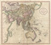
"خريطة جديدة لآسيا، من أحدث المصادر، بقلم جون كاري، النقاش، 1806"، تظهر المحيط الجنوبي الذي يقع إلى الجنوب من المحيط الهندي وأستراليا.
خريطة فريسينيه 1811 - نتجت عن بعثة بودان الفرنسية إلى أستراليا في الفترة 1800-1803، وكانت أول خريطة كاملة لأستراليا تُنشر على الإطلاق. باللغة الفرنسية، أطلقت الخريطة على المحيط الموجود أسفل أستراليا مباشرة اسم المحيط الجنوبي العظيم Grand Océan Austral.
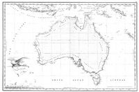
خريطة أستراليا لعام 1863 تُظهر المحيط الجنوبي الذي يقع مباشرة إلى الجنوب من أستراليا.
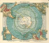
خريطة تعود إلى عام 1906 للناشر الألماني يوستوس پرثس تُظهر القارة القطبية الجنوبية محاطة بمحيط Antarktischer (Sudl. Eismeer) Ocean' - 'محيط أنتاركتيكا (الجنوبي)'.
خريطة العالم عام 1922 الصادرة عن الجمعية الجغرافية الوطنية توضح محيط أنتاركتيكا (الجنوبي).
.jpg&filetimestamp=20240714211426&)


بعثات أنتاركتيكا


في ديسمبر 1839، كجزء من بعثة الاستكشاف الأمريكية التي قامت بها البحرية الأمريكية في الفترة 1838-1842 (والتي تسمى أحيانًا "بعثة ويلكس")، أبحرت البعثة من سيدني، أستراليا، على متن السفينتين الحربيتين يوإسإس ڤينسز ويوإسإس پيكوك، والسفينة ذات الصاريين يوإسإس پورپويز، والسفينة ذات الصواري يوإسإس ليليف، والسفينتين الشراعيتين يوإسإس سي گل ويوإسإس فلاينگ فيش. أبحرت البعثة إلى المحيط المتجمد الجنوبي، كما كان معروفًا آنذاك، وأبلغوا عن اكتشاف "قارة أنتاركتيكا غرب جزر بالني" في 25 يناير 1840. وقد أطلق على ذلك الجزء من القارة القطبية الجنوبية فيما بعد اسم "أرض ويلكس"، وهو الاسم الذي يحتفظ به حتى يومنا هذا.
عام 1841 مر المستكشف جيمس كلارك روس بما يُعرف الآن باسم بحر روس واكتشف جزيرة روس (والتي سُميت كل منهما باسمه). أبحر امتداد طول جدار جليدي ضخم سُمي فيما بعد رصيف روس الجليدي. سُمي جبل إربس وجبل ترور على اسم سفينتين من رحلته الاستكشافية: إتشإمإس ترور وإتشإمإس إربوس.[57]

انطلقت البعثة الإمبراطورية عبر أنتاركتيكا لعام 1914، بقيادة إرنست شاكلتون، لعبور القارة عبر القطب، لكن سفينتهم، إندورانس، علقت وسحقتها كتل الجليد قبل أن ترسو حتى. نجا أعضاء البعثة بعد رحلة ملحمية على الزلاجات فوق كتل الجليد إلى جزيرة إليفانت. ثم عبر شاكلتون وخمسة آخرون المحيط الجنوبي، على متن قارب مفتوح يسمى جيمس كيرد، ثم قاموا برحلة عبر جورجيا الجنوبية لإطلاق ناقوس الخطر في محطة گريتڤيكن لصيد الحيتان.
عام 1946، قام الأميرال البحري الأمريكي ريتشارد بيرد وأكثر من 4.700 عسكري بزيارة أنتاركتيكا في رحلة استكشافية أطلق عليها اسم عملية القفز العالي. أُعلن عن هذه الرحلة للجمهور باعتبارها مهمة علمية، وتم الحفاظ على تفاصيلها سرية وربما كانت في الواقع مهمة تدريب أو اختبار للجيش. حُشدت الرحلة، سواء من حيث التخطيط العسكري أو العلمي، بسرعة كبيرة. احتوت المجموعة على كمية غير عادية من المعدات العسكرية، بما في ذلك حاملة طائرات وغواصات وسفن دعم عسكرية وقوات هجومية ومركبات عسكرية. كان من المقرر أن تستمر الرحلة ثمانية أشهر لكنها انتهت بشكل غير متوقع بعد شهرين فقط. باستثناء بعض الإدخالات الغريبة في مذكرات الأميرال بيرد، لم يتم تقديم أي تفسير حقيقي رسميًا للإنهاء المبكر.
عاد الكابتن فين رون، الضابط التنفيذي لبيرد، إلى أنتاركتيكا مع بعثته الخاصة عامي 1947 و1948، بدعم من البحرية وثلاث طائرات وكلاب. وقد دحض فكرة تقسيم القارة إلى قسمين وأثبت أن شرق وغرب أنتاركتيكا يشكلان قارة واحدة، أي أن بحر ودل وبحر روس غير متصلين.[58] استكشفت البعثة ورسمت خرائط لأجزاء كبيرة من أرض پالمر وساحل بحر ودل، وحددت رصيف رون الجليدي، الذي أطلق عليه هذا الاسم نسبة إلى زوجته جاكي رون.[59] باستخدام الزلاجات والزلاجات التي تجرها الكلاب، قطع مسافة 5.790 كم - أكثر من أي مستكشف آخر في التاريخ.[60] اكتشفت بعثة رون آخر خط ساحلي غير معروف في العالم ورسمت خرائط له، وكانت أول بعثة استكشافية لأنتاركتيكا تضم نساء.[61]
معاهدة ما بعد الأطلسي

في 1 ديسمبر 1959 تم التوقيع على معاهدة أنتارتيكا ودخلت حيز التنفيذ في 23 يونيو 1961. ومن بين أحكامها الأخرى، لا تدعم المعاهدة من الأنشطة العسكرية في أنتارتيكا وتقتصر على دعم البحث العلمي.
كان أول شخص يبحر بمفرده إلى أنتارتيكا هو النيوزيلندي ديڤد هنري لويس، عام 1972، على متن السفينة الشراعية الفولاذية بطول 10 أمتار، آيس بيرد.
في 7 يناير 1978 وُلِد طفل يُدعى إميليو ماركوس دي پالما بالقرب من خليج هوپ، ليصبح أول طفل يولد في القارة. كما وُلِد أيضًا في أقصى مكان جنوباً وُلد فيه شخص من قبل.[62]
إمڤي إكسپلورر 1969 هي سفينة رحلات يديرها المستكشف السويدي لارس إريك ليندبلاد. ويشير المراقبون إلى رحلة إكسپلورر الاستكشافية إلى أنتارتيكاعام 1969 باعتبارها الرائدة في مجال السياحة البحرية في تلك المنطقة في ذلك الوقت.[63][64] كانت إكسپلورر أول سفينة رحلات تستخدم خصيصًا للإبحار في المياه الجليدية للمحيط الجنوبي وأول سفينة تغرق هناك[65]
عندما اصطدمت بجسم مغمور مجهول في 23 نوفمبر 2007، قيل إنه جليد، مما تسبب في حدوث شق في بدن السفينة يبلغ طوله 25 × 10 سم.[66] تم التخلي عن السفينة في الساعات الأولى من 23 نوفمبر 2007 تم التخلي بعد دخولها المياه بالقرب من جزر شتلاند الجنوبية في المحيط الجنوبي، وهي منطقة عاصفة عادة لكنها كانت هادئة في ذلك الوقت.[67] أكدت القوات البحرية التشيلية غرق السفينة إكسپلورر عن الموقع التقريبي: 62° 24′ جنوباً، 57° 16′ غرباً،[68] على بعد 600 متر.[69]
قام المهندس البريطاني ريتشارد جنكنز بتصميم طائرة شراعية مسيرة[70] التي أكملت أول رحلة بحرية مستقلة لها حول المحيط الجنوبي في 3 أغسطس 2019 بعد 196 يومًا في البحر.[71]
تم إنجاز أول رحلة استكشافية كاملة بقوارب تجديف في المحيط الجنوبي في 25 ديسمبر 2019 من قبل فريق من المجدفين يضم القبطان فين پول (أيسلندا)، المساعد الأول كولين أوبرادي (الولايات المتحدة)، أندرو تاون (الولايات المتحدة)، كامرون بلمي (جنوب إفريقيا)، جيمي دوگلاس هاملتون (المملكة المتحدة)، وجون پترسون (الولايات المتحدة).[72]
الجغرافيا
تشكل المحيط الجنوبي، وهو أصغر المحيطات من الناحية الجيولوجية، عندما تباعدت أنتاركتيكا وأمريكا الجنوبية، مما أدى إلى فتح ممر دريك، منذ حوالي 30 مليون سنة. سمح انفصال القارات بتكوين تيار أنتاركتيكا القطبي.
مع وجود حد شمالي عند 60° جنوباً، يختلف المحيط الجنوبي عن المحيطات الأخرى في أن أكبر حدوده، الحد الشمالي، لا يلامس كتلة أرضية (كما كان الحال في الطبعة الأولى من حدود المحيطات والبحار). بدلاً من ذلك، يقع الحد الشمالي مع المحيط الأطلسي والهندي والهادي.
أحد الأسباب التي تجعلنا نعتبر المحيط الجنوبي محيطًا منفصلاً هو أن الكثير من مياه المحيط الجنوبي تختلف عن مياه المحيطات الأخرى. تنتقل المياه حول المحيط الجنوبي بسرعة كبيرة بسبب تيار أنتاركتيكا القطبي الذي يدور حول أنتاركتيكا. تشبه المياه في المحيط الجنوبي جنوب نيوزيلندا، على سبيل المثال، المياه في المحيط الجنوبي جنوب أمريكا الجنوبية أكثر من تشابهها مع مياه المحيط الهادي.
يتراوح عمق المحيط الجنوبي ما بين 4000 و5000 متر على معظم امتداده مع وجود مناطق محدودة من المياه الضحلة. ويصل أقصى عمق للمحيط الجنوبي إلى 7236 مترًا عند الطرف الجنوبي من خندق ساندويتش الجنوبي، عند 60°00' جنوباً، 024 غرباً. ويبدو رصيف أنتاركتيكا القاري ضيقًا بشكل عام وعميقًا بشكل غير عادي، حيث تصل حافته إلى أعماق تصل إلى 800 متر، مقارنة بمتوسط عالمي يبلغ 133 مترًا.
من الاعتدال الشمسي إلى الاعتدال الشمسي بما يتماشى مع تأثير الشمس الموسمي، تتقلب مساحة الغطاء الجليدي في أنتاركتيكا من متوسط أدنى يبلغ 2.6 مليون كيلومتر مربع في مارس إلى حوالي 18.8 مليون كيلومتر مربع في سبتمبر، أي أكثر من سبعة أضعاف الزيادة في المساحة.
التقسيمات

التقسيمات الفرعية للمحيطات هي سمات جغرافية مثل "البحار" و"المضايق" و"الخلجان" و"القنوات". هناك العديد من التقسيمات للمحيط الجنوبي تم تعريفها في مسودة الطبعة الرابعة التي لم يصدق عليها منشور المنظمة الهيدروغرافية الدولية حدود المحيطات والبحار لعام 2002. وتتضمن هذه التقسيمات (مع القطاع) بالترتيب في اتجاه عقارب الساعة ما يلي:
- بحر ودل (57°18'غرباً – 12°16'شرقاً)
- بحر الملك هآكون السابع[note 5] (20°غرباً – 45°شرقاً)
- بحر لازارڤ (0° – 14°شرقاً)
- بحر ريسر-لارسن (14° – 30°شرقاً)
- بحر كوزموناتس (30° – 50°شرقاً)
- بحر كوپريشن (59°34' – 85°شرقاً)
- بحر ديڤس (82° – 96°شرقاً)
- بحر ماوسون (95°45' – 113°شرقاً)
- بحر دورڤيل (140°شرقاً)
- بحر سوموڤ (150° – 170°شرقاً)
- بحر روس (166°شرقاً – 155°غرباً)
- بحر أموندسن (102°20′ – 126°غرباً)
- بحر بلنگهاوزن (57°18' – 102°20'غرباً)
- جزء من ممر دريك[note 6] (54° – 68°غرباً)
- مضيق برانزفيلد (54° – 62°غرباً)
- جزء من بحر سكوتشيا[note 7] (26°30' – 65°غرباً)
لا يتم تضمين عدد من هذه المناطق مثل "بحر كوزموناتس " و"بحر كوپريشن" و"بحر سوموڤ" (مستكشف القطب الشمالي الروسي في منتصف الخمسينيات) الذي اقترحته روسيا عام 2002 في وثيقة المنظمة الهيدروغرافية الدولية لعام 1953 والتي لا تزال سارية المفعول حاليًا،[34] لأنها حصلت على اسمائها التي نشأت إلى حد كبير من عام 1962 فصاعدًا. لا تستخدم السلطات الجغرافية الرائدة والأطالس هذه الأسماء الثلاثة الأخيرة، بما في ذلك أطلس العالم العاشر لعام 2014 من الجمعية الجغرافية الوطنية الأمريكية والطبعة الثانية عشرة لعام 2014 من تايمز أطلس العالم البريطاني، لكن الخرائط الصادرة عن الاتحاد السوڤيتي وروسيا لا تستخدمها.[73][74]
أكبر البحار
أكبر بحار المحيط الجنوبي:[75][76][77]
- بحر ودل – 2.800.000 كم²
- بحر سوموڤ – 1.150.000 كم²
- بحر ريسر-لارسن – 1.138.000 كم²
- بحر لازرڤ – 929.000 كم²
- بحر سكوتشيا – 900.000 كم²
- بحر كوزموناتس – 699.000 كم²
- بحر روس – 637.000 كم²
- بحر بلنگهاوزن – 487.000 كم²
- بحر ماوسون – 333.000 كم²
- بحر كوپريشن – 258.000 كم²
- بحر أموندسن – 98.000 كم²
- بحر ديڤس – 21.000 كم²
- بحر دورڤيل
- بحر الملك هآكون السابع
الموارد الطبيعية

من المحتمل أن المحيط الجنوبي يحتوي على حقول ضخمة وربما عملاقة من النفط والغاز على الهامش القاري. ومن المتوقع أيضًا وجود رواسب من المعادن الثمينة مثل الذهب، والتي تشكلت عن طريق فصل الجاذبية أثناء العمليات الرسوبية في المحيط الجنوبي.[5]
من المتوقع وجود كرات منجنيز في المحيط الجنوبي. كرات المنجنيز هي كتل متحجرة على قاع البحر تتكون من طبقات متحدة المركز من الحديد وهيدروكسيد المنجنيز حول اللب. قد يكون اللب صغيرًا جدًا ويتحول أحيانًا بالكامل إلى معادن منجنيز عن طريق التبلور. أدى الاهتمام بالاستغلال المحتمل للكرات متعددة المعادن إلى توليد قدر كبير من النشاط بين اتحادات التعدين المحتملة في الستينيات والسبعينيات.[5]
تحتوي الجبال الجليدية التي تتشكل حول المحيط الجنوبي سنوياً على ما يكفي من المياه العذبة لتلبية احتياجات كل شخص على وجه الأرض لعدة أشهر. وعلى مدى عدة عقود، كانت هناك مقترحات، لم يكن أي منها قابلاً للتنفيذ أو ناجحًا حتى الآن، لسحب الجبال الجليدية في المحيط الجنوبي إلى مناطق شمالية أكثر جفافًا (مثل أستراليا) حيث يمكن حصادها.[78]
المخاطر الطبيعية
.jpg&filetimestamp=20240714211520&)
يمكن أن تظهر الجبال الجليدية في أي وقت من العام في جميع أنحاء المحيط. وقد يصل عمق بعضها إلى عدة مئات من الأمتار؛ كما تشكل الجبال الجليدية الأصغر حجمًا وحطام الجبال الجليدية والجليد البحري (يبلغ سمكها عمومًا 0.5-1 متر) مشكلات للسفن. وتتكون أرضية الرصيف القاري العميق من رواسب جليدية تتنوع على نطاق واسع على مسافات قصيرة.
يعرف البحارة خطوط العرض من 40 إلى 70° جنوباً درجة جنوبًا]] باسم "الأربعينات الهادرة" و"الخمسينيات الهائجة" و"الستينيات الصارخة" بسبب الرياح العاتية والأمواج الكبيرة التي تتشكل عندما تهب الرياح حول العالم بالكامل دون أن تعوقها أي كتلة أرضية. وتزيد الجبال الجليدية، وخاصة في الفترة من مايو إلى أكتوبر، من خطورة المنطقة. كما أن عزلة المنطقة تجعل مصادر البحث والإنقاذ نادرة.
علم المحيطات الفيزيائي

التيار القطبي والتقارب القطبي
في حين أن المحيط الجنوبي هو ثاني أصغر المحيطات، إلا أنه يحتوي على تيار أنتاركتيكا القطبي الفريد والنشط للغاية والذي يتحرك باستمرار نحو الشرق - يطارد نفسه وينضم لنفسه، ويبلغ طوله 21.000 كيلومتر - ويضم أطول تيار محيطي في العالم، وينقل 130 مليون م²/ث من المياه - 100 ضعف تدفق جميع أنهار العالم.[79]
تحدث عدة عمليات على امداد ساحل أنتاركتيكا لإنتاج أنواع من الكتل المائية في المحيط الجنوبي لا تُنتج في أي مكان آخر في محيطات نصف الكرة الأرضية الجنوبي. إحدى هذه العمليات ي مياه أنتاركتيكا القاعية، وهي مياه شديدة البرودة ومالحة وكثيفة تتكون تحت الجليد البحري. نوع آخر من تلك العمليات هي مياه الأعماق القطبية، وهي مزيج من مياه أنتاركتيكا القاعية ومياه أعماق شمال الأطلسي.
يرتبط تيار التقارب القطبي بتيار أنتاركتيكا القطبي الذي يحيط بأنتاركتيكا، حيث تلتقي مياه أنتاركتيكا الباردة المتدفقة شمالاً بمياه subantarctic الدافئة نسبياً، وتغوص مياه أنتاركتيكا بشكل أساسي تحت مياه subantarctic، بينما تخلق مناطق الاختلاط التيار الصاعد المرتبطة بها منطقة غنية للغاية بالعناصر الغذائية. وتغذي هذه المناطق مستويات عالية من العوالق النباتية مع القشريات المرتبطة بها وكرل أنتاركتيكا، والسلاسل الغذائية الناتجة التي تدعم الأسماك والحيتان والفقمة والبطاريق والنوارس وثروات الأنواع الأخرى.[80]
يُعتبر تقارب أنتاركتيكا أفضل تعريف طبيعي للحد الشمالي للمحيط الجنوبي.

التيار الصاعد
توجد ظاهرة التيار الصاعد واسعة النطاق في المحيط الجنوبي. تهب رياح غربية قوية (باتجاه الشرق) حول أنتاركتيكا، مما يدفع تدفقًا كبيرًا للمياه نحو الشمال. هذا في الواقع نوع من ارتفاع المياه الساحلية. نظرًا لعدم وجود قارات في شريط من خطوط العرض المفتوحة بين أمريكا الجنوبية وطرف شبه جزيرة أنتاركتيكا، فإن بعض هذه المياه تسحب من أعماق كبيرة. في العديد من النماذج العددية والتقارير الرصدية، يمثل التيار الصاعد في المحيط الجنوبي الوسيلة الأساسية التي يتم من خلالها جلب المياه الكثيفة العميقة إلى السطح. توجد أيضًا ارتفاعات مياه ضحلة مدفوعة بالرياح قبالة السواحل الغربية لأمريكا الشمالية والجنوبية وشمال غرب وجنوب غرب أفريقيا وجنوب غرب وجنوب شرق أستراليا، وكلها مرتبطة بدورات الضغط المرتفع شبه الاستوائية المحيطية.

دوامات روس وودل
دوامة روس ودوامة ودل هما دوامتان محيطيتان توجدان داخل المحيط الجنوبي. تقع الدوامتان في بحر روس وبحر ودل على التوالي، وكلاهما يدور في اتجاه عقارب الساعة. تتشكل الدوامتان من خلال التفاعلات بين تيار أنتاركتيكا القطبي ورصيف أنتاركتيكا الجليدي.
لوحظ أن الجليد البحري لا يزال موجودًا في المنطقة الوسطى من دوامة روس.[81] هناك بعض الأدلة على أن الاحترار العالمي أدى إلى انخفاض ملوحة مياه دوامة روس منذ الخمسينيات.[82]
نتيجة لأثر كوريوليس الذي يعمل إلى اليسار في نصف الكرة الجنوبي ونقل إيكمان الناتج بعيدًا عن مراكز دوامة ودل، فإن هذه المناطق منتجة للغاية بسبب التيار الصاعد للمياه الباردة الغنية بالمغذيات.

الرصد
يتم تنسيق رصد المحيط الجنوبي من خلال نظام رصد المحيط الجنوبي (SOOS).[83][84] يتيح هذا الوصول إلى البيانات الوصفية لنسبة كبيرة من البيانات التي تم جمعها في المناطق على مدى العقود الماضية بما في ذلك القياسات الهيدروغرافية والتيارات المحيطية. تم إعداد توفير البيانات للتأكيد على السجلات المتعلقة بالمتغيرات المحيطية الأساسية (EOVs)[85] لمنطقة المحيط جنوب 40° جنوباً.
المناخ
تتراوح درجات حرارة البحر من حوالي -2 إلى 10 درجات مئوية. تنتقل العواصف الإعصارية شرقًا حول القارة وتصبح شديدة في كثير من الأحيان بسبب التباين في درجات الحرارة بين الجليد والمحيط المفتوح. يتمتع المحيط من حوالي خط العرض 40°جنوباً إلى الدائرة القطبية الجنوبية بأقوى رياح متوسطة موجودة في أي مكان على وجه الأرض.[86]
في الشتاء يتجمد سطج المحيط حتى خط العرض 65° جنوباً في قطاع المحيط الهادي وخط العرض 55° جنوباً في قطاع المحيط الأطلسي، مما يؤدي إلى انخفاض درجات حرارة السطح إلى ما دون الصفر المئوي. وفي بعض النقاط الساحلية، تعمل رياح الصرف القوية المستمرة القادمة من الداخل على إبقاء الشاطئ خاليًا من الجليد طوال فصل الشتاء.

التغير

وبما أن انبعاثات غازات الدفيئة الناجمة عن النشاط البشري تسبب ارتفاع درجات الحرارة، فإن أحد أبرز تأثيرات تغير المناخ على المحيطات هو زيادة محتوى الحراري للمحيط، والذي يمثل أكثر من 90% من إجمالي الاحترار العالمي منذ عام 1971.[93] منذ عام 2005، من 67% إلى 98% من هذه الزيادة حدثت في المحيط الجنوبي.[94] في غرب أنتاركتيكا، ارتفعت درجة الحرارة في الطبقة العليا من المحيط بمقدار درجة واحدة مئوية منذ عام 1955، كما أن تيار أنتاركتيكا القطبي يرتفع أيضًا بشكل أسرع من المتوسط العالمي.[95]
يؤثر هذا الاحترار بشكل مباشر على تدفق الكتل المائية الدافئة والباردة التي تشكل الدورة الانقلابية، كما أن له تأثيرات سلبية على غطاء الجليد البحري في نصف الكرة الجنوبي (الذي يتميز بقدرة عالية على الانعكاس وبالتالي يرفع من مستوى نصوع سطح الأرض)، بالإضافة إلى توازن الكتلة في الأرصفة الجليدية في أنتاركتيكا والمثالج الطرفية.[96] لهذه الأسباب، تظهر نماذج المناخ باستمرار أن العام الذي سيصل فيه الانحباس الحراري العالمي إلى -2° مئوية (وهو أمر لا مفر منه في جميع سيناريوهات تغير المناخ حيث لم تنخفض انبعاثات غازات الدفيئة بشكل كبير) يعتمد على حالة الدورة أكثر من أي عامل آخر إلى جانب الانبعاثات نفسها.[97]

بالإضافة إلى ذلك، فإن النمط الرئيسي المتحكم في مناخ نصف الكرة الجنوبي فوق المداري هو الوضع الحلقي الجنوبي (SAM)، والذي قضى سنوات عديدة في مرحلته الإيجابية بسبب تغير المناخ (وكذلك في أعقاب استنزاف الأوزون)، مما يعني المزيد من الاحترار والمزيد من سقوط الأمطار فوق المحيط بسبب الرياح الغربية الأقوى، مما يؤدي إلى تجدد المحيط الجنوبي بشكل أكبر.[94][96] لا تتفق نماذج المناخ حاليًا على ما إذا كانت دورة المحيط الجنوبي ستستمر في الاستجابة للتغيرات في الوضع الحلقي الجنوبي بالطريقة التي تفعلها الآن، أو ما إذا كانت ستتكيف معها في النهاية. اعتبارًا من أوائل ع. 2020، فإن أفضل تقديراتهم المحدودة الثقة هي أن الخلية السفلية ستستمر في الضعف، بينما قد تتعزز الخلية العلوية بنحو 20% على مدار القرن 21.[96] أحد الأسباب الرئيسية لعدم اليقين هو التمثيل الضعيف وغير المتسق لطبقات المحيطات حتى في نماذج مشروع مقارنة النماذج CMIP6- وهو الجيل الأكثر تقدمًا المتاح اعتبارًا من أوائل ع. 2020.[91] علاوة على ذلك، فإن الدور الأكبر على المدى الطويل في حالة الدورة يلعبه الماء الذائب في أنتاركتيكا،[99] وكان فقدان الجليد في أنتاركتيكا هو الجانب الأقل يقيناً في توقعات ارتفاع مستوى سطح البحر في المستقبل لفترة طويلة.[100]

التنوع الحيوي

الحيوانات
توجد مجموعة متنوعة من الحيوانات البحرية والتي تعتمد بشكل مباشر أو غير مباشر على العوالق النباتية في المحيط الجنوبي. تشمل الحياة البحرية في القارة القطبية الجنوبية البطاريق، الحوت الأزرق، الأوركا، الحبار العملاق، فقمة الفراء. البطريق الإمبراطور هو البطريق الوحيد الذي يتكاثر خلال فصل الشتاء في القارة القطبية الجنوبية، بينما يتكاثر بطريق أديلي في الجنوب أكثر من أي نوع آخر من البطاريق. يتميز البطريق النطاط بريش مميز حول عينيه، مما يعطي مظهر الرموش المعقدة. يتكاثر أيضًا البطريق الملك، والبطريق ملجم، وبطريق جنتو في أنتاركتيكا.
كان فقمة فراء أنتاركتيكا تتعرض للصيد بكثافة في القرنين الثامن عشر والتاسع عشر من أجل فرائها، من قبل صائدي الفقمة من الولايات المتحدة والمملكة المتحدة. فقمة ودل، "فقمة حقيقية"، سُميت على اسم السير جيمس ودل، قائد بعثات صيد الفقمة البريطانية في بحر ودل. يُعد كيرل أنتاركتيكا، الذي يتجمع في أسراب كبيرة، النوع الرئيسي في نالظام البيئي للمحيط الجنوبي، وهو عضية غذائية هامة للحيتان والفقمات وفقمة النمر وفقمة الفراء والحبار والأسماك الجليدية والبطاريق والقطارس والعديد من الطيور الأخرى.[103]
تتميز تجمعات قاع البحر بالتنوع والكثافة، حيث يصل عدد الحيوانات الموجودة في متر مربع واحد إلى 155.000 حيوان. ونظرًا لأن بيئة قاع البحر متشابهة للغاية في جميع أنحاء أنتاركتيكا، فيمكن العثور على مئات الأنواع في جميع أنحاء البر الرئيسي، وهو توزيع موسع بشكل فريد لمثل هذا المجتمع الضخم. عملقة أعماق البحار شائعة بين هذه الحيوانات.[104]
عام 2010، نُشر إحصاء للحياة البحرية أجري خلال السنة القطبية الدولية وشارك فيه حوالي 500 باحث. ويشكل البحث جزءًا من إحصاء الحياة البحرية العالمي (CoML) وقد كشف عن بعض النتائج الرائعة. يعيش أكثر من 235 كائنًا بحريًا في المنطقتين القطبيتين، بعد أن سدوا الفجوة التي تبلغ 12.000 كيلومتر. وتقوم الحيوانات الكبيرة مثل بعض الحيتانيات والطيور برحلة ذهاب وإياب سنوية. والأكثر إثارة للدهشة هي أشكال الحياة الصغيرة مثل ديدان الطين وخيار البحر والقواقع التي تسبح بحرية والتي توجد في كلا المحيطين القطبيين. وقد تساعد عوامل مختلفة في توزيعها - درجات الحرارة المتجانسة إلى حد ما في أعماق المحيط عند القطبين وخط الاستواء والتي لا تختلف بأكثر من 5 درجات مئوية، وأنظمة التيارات الرئيسية أو حزام النقل البحري الذي ينقل مراحل البيض واليرقات.[105] بين الحيوانات البحرية الأصغر حجمًا والتي يُفترض عمومًا أنها متماثلة في أنتاركتيكا والقطب الشمالي، غالبًا ما كشفت الدراسات الأكثر تفصيلاً لكل مجموعة سكانية عن اختلافات - ولكن ليس دائمًا - مما يدل على أنها من الأنواع الغامضة وثيقة الصلة وليست نوعاً واحداً في كلا القطبين.[106][107][108]

.jpg&filetimestamp=20240714211405)
.jpg&filetimestamp=20240714211520)
الطيور
توفر شواطئ أنتاركتيكا الصخرية وجزرها الساحلية مساحة تعشيش لأكثر من 100 مليون طائر كل ربيع. وتشمل هذه الطيور أنواعًا من طيور القطرس، طيور النوء، الكركر، النورس، والخرشنة.[109] جشنة جورجيا الجنوبية هو طائر متوطن في جورجيا الجنوبية وبعض الجزر الصغيرة المحيطة. يعيش بط المياه العذبة في جورجيا الجنوبية وجزر كرگيلن.[110]
توجد جميع أنواع [بطريق|البطاريق]] غير القادرة على الطيران في نصف الكرة الجنوبي، مع وجود أكبر تركيز لها في أنتاركتيكا وحولها. تعيش أربعة من الأنواع الثمانية عشر من البطاريق وتتكاثر على البر الرئيسي والجزر القريبة منه. وتعيش أربعة أنواع أخرى على جزر subantarctic.[111] يتمتع البطريق الإمبراطور بأربع طبقات متداخلة من الريش، مما يجعلها دافئة. وهو الحيوان الوحيد في أنتاركتيكا الذي يتكاثر خلال فصل الشتاء.[112]
الأسماك
في المحيط الجنوبي يوجد عدد قليل نسبيًا من أنواع الأسماك ضمن بضع فصائل. الفصيلة الأكثر ثراءً بالأنواع هي سمك الحلزون، يليه القد الجليدي[113] الإلبوت. تشكل أسماك الحلزون وnotothenioid (التي تشمل سمك القد الجليدي والعديد من الفصائل الأخرى) معًا ما يقرب من 9⁄10 من أكثر من 320 نوعًا من أنواع الأسماك الموصوفة في المحيط الجنوبي (توجد أيضًا عشرات الأنواع غير الموصوفة في المنطقة، وخاصة بين أسماك الحلزون).[114] في المحيط الجنوبي توجد أسماك الحلزون بشكل عام في المياه العميقة، بينما توجد الأسماك الجليدية أيضًا في المياه الضحلة.[113]
الأسماك الجليدية

سمك القد الجليدية، بالإضافة إلى العديد من الفصائل الأخرى، هي جزء من رتبة سمكاوات القد الجليدية الفرعية، والتي يشار إليها أحيانًا بشكل جماعي باسم أسماك الجليد. تحتوي الرتبة الفرعية على العديد من الأنواع التي تحتوي على پروتينات مضادة للتجمد في دمها وأنسجتها، مما يسمح لها بالعيش في الماء الذي تبلغ درجة حرارته حوالي 0 درجة مئوية أو أقل قليلاً.[115][116] من المعروف أيضًا أن الپروتينات المضادة للتجمد موجودة في الأسماك الحلزونية في المحيط الجنوبي.[117]
توجد أسماك التمساح الجليدية، والمعروفة أيضًا باسم الأسماك ذات الدم الأبيض، في المحيط الجنوبي فقط. تفتقر هذه الأسماك إلى الهيموگلوبين في دمها، مما يؤدي إلى أن يكون دمها عديم اللون. كان أحد أنواع أسماك الجليد التمساحية، وهو أسماك الماكريل الجليدية، أكثر الأسماك شيوعًا في المياه الساحلية التي يقل عمقها عن 400 متر، لكنها تعرضت للصيد المفرط في السبعينيات والثمانينيات. تقضي أسراب الأسماك الجليدية اليوم في قاع البحر والليل في أعلى عمود الماء وتأكل العوالق والأسماك الأصغر حجمًا.[115]
هناك نوعان من جنس الأسماك المسننة، أسماك أنتاركتيكا المسننة وأسماك پاتاگونية المسننة يعيش هذان النوعان على قاع البحر على عمق يتراوح بين 100 و3000 متر، ويمكن أن يصل طولهما إلى حوالي 2 متر ويصل وزنهما إلى 100 كجم، ويعيشان حتى 45 عامًا. تعيش سمكة أنتاركتيكا المسننة بالقرب من البر الرئيسي في القطب الجنوبي، بينما تعيش أسماك پاتاگونية المسننة في المياه شبه القطبية الجنوبية الأكثر دفئًا نسبيًا. يتم صيد سمكة المسننة تجاريًا، وقد أدى الإفراط في صيدها إلى تقليص أعداد الأسماك المسننة.[115][118]
مجموعة أخرى وفيرة من الأسماك هو جنس Notothenia، والتي مثل أسماك أنتاركتيكا المسننة لديها مادة مضادة للتجمد في أجسامها.[115]
نوع غير عادي من الأسماك الجليدية هو أسماك أنتاركتيكا الفضية، وهي سمكة البحر المفتوح الوحيدة الحقيقية في المياه القريبة من أنتاركتيكا.[119]

الثدييات
تعيش سبعة أنواع من زعنفيات الأقدام في أنتاركتيكا. أكبرها، فقمة الفيل، التي يمكن أن يصل وزنها إلى 4000 كيلوجرام، بينما يصل وزن إناث الأصغر منها، فقمة فراء أنتاركتيكا إلى 150 كيلوجرامًا فقط. يعيش هذان النوعان شمال الجليد البحري، ويتكاثران في مستعمرات على الشواطئ. يمكن للأنواع الأربعة الأخرى أن تعيش على الجليد البحري. تشكل الفقمات آكلة سرطان البحر وفقمات ودل مستعمرات للتكاثر، بينما تعيش فقمات النمر وفقمات روس حياة منعزلة. ورغم أن هذه الأنواع تصطاد تحت الماء، إلا أنها تتكاثر على الأرض أو الجليد وتقضي وقتًا طويلاً هناك، حيث لا ليس لها مفترسات على الأرض.[120]
يُعتقد أن الأنواع الأربعة التي تعيش على الجليد البحري تشكل 50% من إجمالي الكتلة الحيوية لفقمات العالم.[121]
يبلغ عدد فقمة آكلة السرطان حوالي 15 مليونًا، مما يجعلها واحدة من أكثر الحيوانات الكبيرة عددًا على هذا الكوكب.[122]
أسد البحر النيوزيلندي، أحد أندر زعانف الأقدام وأكثرها استيطاناً، يتكاثر حصريًا تقريبًا في جزر أوكلاند الواقعة جنوب أنتاركتيكا، على الرغم من أنه كان له تاريخيًا نطاق أوسع.[123] من بين جميع الثدييات المقيمة الدائمة، تعيش فقمة ودل في أقصى الجنوب.[124]
يوجد 10 أنواع من الحيتانيات في المحيط الجنوبي: ستة حيتان بالينية، وأربعة حيتان مسننة. أكبر هذه الأنواع، الحوت الأزرق، ويصل طوله إلى 24 مترًا ويزن 84 طنًا. العديد من هذه الأنواع مهاجرة، وتنتقل إلى المياه الإستوائية خلال فصل الشتاء في أنتاركتيكا.[125]
.jpg&filetimestamp=20231025053429&)
.jpg&filetimestamp=20231025053429)
Invertebrates
مفصليات الأرجل
هناك خمسة أنواع من الكريل في المحيط الجنوبي.[126] كريل أنتاركتيكا هو أحد أكثر أنواع الحيوانات وفرة على وجه الأرض، حيث تبلغ كتلته الحيوية حوالي 500 مليون طن. يبلغ طول كل فرد 6 سم ويزن أكثر من 1 جرام.[127] يمكن أن تمتد الأسراب التي تتشكل لعدة كيلومترات، مع ما يصل إلى 30.000 فرد لكل متر مكعب، مما يحول الماء إلى اللون الأحمر.[126] تظل الأسراب عادة في المياه العميقة أثناء النهار، وتصعد أثناء الليل لتتغذى على العوالق. وتعتمد العديد من الحيوانات الأكبر حجمًا على الكريل من أجل بقائها.[127] خلال فصل الشتاء عندما يكون الطعام نادرًا، يمكن لكريل أنتاركتيكا البالغ أن يعود إلى مرحلة أصغر حجمًا، باستخدام أجسامها كغذاء.[126]
العديد من قشريات القاع لها دورة التكاثر الغير موسمية، وبعضها يربي صغاره في كيس تحضين. Glyptonotus antarcticus هو نظير قاعي متساوي الأقدام كبير بشكل غير عادي، يصل طوله إلى 20 سم ويزن 70 جرامًا. مزدوجات الأرجل وفيرة في الرواسب اللينة، وتأكل مجموعة من العناصر، من الأشنيات إلى الحيوانات الأخرى.[104] تتميز البرمائيات بتنوعها الشديد، حيث يوجد أكثر من 600 نوع معروف جنوب منطقة تقارب أنتاركتيكا، وهناك مؤشرات على أن العديد من الأنواع غير الموصوفة لا تزال موجودة. ومن بين هذه الأنواع العديد من "العمالقة"، مثل epimeriids الأسطورية التي يصل طولها إلى 8 سم.[128]
العناكب البحرية بطيئة الحركة شائعة، وأحيانًا تنمو بحجم يد الإنسان. تتغذى على الإسفنج، الشعاب المرجانية والمرجانيات التي تنتشر في قاع البحر.[104]

الرخويات والقنافذ والحبار والإسفنج
يوجد العديد من الرخويات المائية في أنتاركتيكا. تتحرك الرخويات مثل محار أنتاركتيكا المروحي حول قاع البحر، بينما تعيش أنواع أخرى مثل Laternula elliptica في جحور ترشيح المياه العليا.[104]
يوجد في المحيط الجنوبي حوالي 70 نوعًا من الرأسقدميات،[129] أكبرها هو الحبار الضخم، والذي يصل طوله إلى 14 مترًا ويعد من أكبر اللافقاريات في العالم.[130]
يشكل الحبار معظم المنظومة الغذائية لبعض الحيوانات، مثل القطرس رمادي الرأس وحيتان العنبر، والحبار الثؤلولي هو أحد أكثر الأنواع التي تتعرض للافتراس من قبل الفقاريات في منطقة subantarctic.[129]
يحفر قنفذ البحر في الرواسب ويأكل العناصر الغذائية التي يجدها فيها.[104] هناك نوعان من الهلاميات البرميلية شائعان في مياه أنتاركتيكا: Salpa thompsoni و Ihlea racovitzai. Salpa thompsoni يتواجدان في المناطق الخالية من الجليد، في حين يوجد Ihlea racovitzai في المناطق ذات خطوط العرض المرتفعة بالقرب من الجليد. وبسبب قيمتها الغذائية المنخفضة، لا تأكلها عادة إلا الأسماك، بينما تأكلها الحيوانات الأكبر حجمًا مثل الطيور والثدييات البحرية فقط عندما يكون الغذاء الآخر نادرًا.[131]
تتمتع إسفنجيات أنتاركتيكا بعمر طويل وحساسة للتغيرات البيئية بسبب خصوصية التجمعات الدقيقة الميكروبية التعايشية داخلها. تيجة لذلك، تعمل الإسفنجيات كمؤشرات للصحة البيئية.[132]
البيئة
أدى ارتفاع الأشعة فوق البنفسجية الشمسية الناتجة عن ثقب الأوزون في أنتاركتيكا إلى انخفاض الإنتاجية الأولية البحرية (العوالق النباتية) بنسبة تصل إلى 15% وبدأ في إتلاف الحمض النووي لبعض الأسماك.[133] ومن المرجح أن يؤثر الصيد غير القانوني وغير المبلغ عنه وغير المنظم، وخاصة إنزال ما يقدر بنحو خمسة إلى ستة أضعاف من الأسماك المسننة الپتاگونية مقارنة بالصيد المنظم، على استدامة المخزون. ويتسبب صيد الأسماك المسننة بالخيوط الطويلة في ارتفاع معدل وفيات الطيور البحرية.
الاتفاقيات الدولية

تنطبق جميع الاتفاقيات الدولية المتعلقة بمحيطات العالم على المحيط الجنوبي، كما يخضع أيضًا لعدة اتفاقيات إقليمية:
تحظر محمية حيتان المحيط الجنوبي التابعة للجنة الدولية لصيد الحيتان صيد الحيتان تجاريًا جنوب خط العرض 40° جنوباً (جنوب خط العرض 60° جنوباً بين خط الطول 50° غرباً وخط الطول 130° غرباً). لا تعترف اليابان بهذا البند بانتظام، لأن المحمية تنتهك ميثاق اللجنة الدولية لصيد الحيتان. نظرًا لأن نطاق المحمية يقتصر على صيد الحيتان التجاري، فيما يتعلق بتصريح صيد الحيتان وصيد الحيتان لأغراض البحث العلمي، فقد نفذ أسطول ياباني صيد الحيتان سنويًا في المنطقة. في 31 مارس 2014، قضت محكمة العدل الدولية بأن برنامج صيد الحيتان الياباني، والذي طالما ادعت اليابان أنه لأغراض علمية، كان مجرد غطاء لصيد الحيتان لأغراض تجارية، ولن يتم منح أي تصاريح أخرى.
تشكل اتفاقية الحفاظ على فقمة أنتاركتيكا جزءًا من نظام معاهدة أنتاركتيكا. وقد تم التوقيع عليها في ختام مؤتمر متعدد الأطراف عُقد في لندن في 11 فبراير 1972.[134]
اتفاقية حفظ الموارد البحرية الحية في أنتاركتيكا هي جزء من نظام معاهدة أنتاركتيكا. دخلت الاتفاقية حيز التنفيذ في 7 أبريل 1982 بهدف الحفاظ على الحياة البحرية والسلامة البيئية في أنتاركتيكا وما حولها. وقد تأسست إلى حد كبير بسبب المخاوف من أن زيادة صيد الكريل في المحيط الجنوبي قد يؤثر بشكل خطير على مجموعات الحياة البحرية الأخرى التي تعتمد على الكريل في غذائها.[135]
تمنع العديد من الدول التنقيب عن واستغلال الموارد المعدنية جنوب منطقة تقارب أنتاركتيكا المتقلبة،[136] التي تقع في منتصف التيار القطبي الجنوبي وتعمل كخط فاصل بين المياه السطحية القطبية شديدة البرودة إلى الجنوب والمياه الدافئة إلى الشمال. تغطي معاهدة أنتاركتيكا الجزء من الكرة الأرضية الواقع جنوب 60° جنوباً؛[137] يحظر المطالبات الجديدة في أنتاركتيكا.[138]
تنطبق "اتفاقية حفظ الموارد البحرية الحية في أنتاركتيكا" على المنطقة الواقعة جنوب خط عرض 60° جنوباً وكذلك المناطق الواقعة إلى الشمال حتى حدود تقارب أنتاركتيكا.[139]
الاقتصاد
في الفترة من 1 يوليو 1998 حتى 30 يونيو 1999، تم إنزال 119.898 طنًا من الأسماك في مصايد الأسماك، منها 85% تتكون من الكريل و14% من السمك المسنن الپاتاگوني. دخلت الاتفاقيات الدولية حيز التنفيذ في أواخر 1999 للحد من الصيد غير القانوني وغير المبلغ عنه وغير المنظم، والذي أدى في موسم 1998-1999 إلى إنزال خمسة إلى ستة أضعاف من السمك المسنن پاتاگوني مقارنة بالصيد المنظم.
الموانئ والمرافئ

تشمل الموانئ التشغيلية الرئيسية: محطة روثرا، محطة پالمر، ڤيلا لاس إسترلاس، قاعدة إسپرانزا، محطة ماوسون، محطة مكمردو، والمراسي البحرية في أنتاركتيكا.
توجد موانئ أو مرافئ قليلة على الساحل الجنوبي (أنتاركتيكا) للمحيط الجنوبي، حيث تحد ظروف الجليد من استخدام معظم الشواطئ لفترات قصيرة في منتصف الصيف؛ وحتى في هذه الحالة، تتطلب بعض الموانئ مرافقة كاسحات الجليد للوصول إليها. تدير محطات الأبحاث الحكومية معظم موانئ أنتاركتيكا، وباستثناء حالات الطوارئ، تظل مغلقة أمام السفن التجارية أو الخاصة؛ تخضع السفن في أي ميناء جنوب خط العرض 60° جنوباً للتفتيش من قبل مراقبي معاهدة أنتاركتيكا.
أقصى موانئ المحيط الجنوبي جنوباً، يقع في محطة مكمردو عند الإحداثيات 77°50′S 166°40′E / 77.833°S 166.667°E. يشكل خليج وينتر كوارترز ميناءً صغيرًا، على الطرف الجنوبي لجزيرة روس، حيث يجعل الرصيف الجليدي العائم عمليات الميناء ممكنة في الصيف. عام 1973 قام أفراد عملية التجميد العميق ببناء أول رصيف جليدي في مكمردو.[140]
استنادًا إلى ترسيم المنظمة الهيدروغرافية الدولية الأصلي عام 1928 للمحيط الجنوبي (وترسيم عام 1937 إذا أثعتبر الخليج الأسترالي العظيم جزءًا لا يتجزأ منه)، سيتم أيضًا تحديد الموانئ والمرافئ الأسترالية الواقعة بين كيپ ليوين وكيپ أوتواي على البر الرئيسي الأسترالي وعلى امتداد الساحل الغربي لتازمانيا باعتبارها موانئ ومرافئ المحيط الجنوبي. ويشمل ذلك الموانئ والمرافئ الأكبر حجمًا في ألباني، ثڤنارد، ميناء لنكلن، وايالا وميناء أوگوستا وميناء أديلايد وپورتلاند ووارنامبول وميناء مكواري.
على الرغم من أن منظمي العديد من سباقات اليخوت يحددون مساراتهم على أنها تشمل المحيط الجنوبي، فإن المسارات الفعلية لا تدخل الحدود الجغرافية الفعلية للمحيط الجنوبي. بدلاً من ذلك تشمل المسارات جنوب الأطلسي وجنوب المحيط الهادي والمحيط الهندي.[141][142][143]
انظر أيضاً
- حدود المحيطات
- قائمة جزر أنتارتيكا
- قائمة البلدان حسب أقصى نقطة جنوباً
- قائمة الجبال البحرية في المحيط الجنوبي
- البحار السبع
- الأربعينات الهادرة
- مخطط قياس الأعماق الدولي للمحيط الجنوبي
الهوامش
- ^ Also a translation of its former French name (Grand Océan Austral) in reference to its position below the Pacific, the "Grand Océan".
- ^ Used by Dr. Hooker in his accounts of his Antarctic voyages.[4] Also a translation of the ocean's Japanese name Nankyoku Kai (南極海).
- ^ Also a translation of the ocean's Chinese name Nánbīng Yáng (南冰洋).
- ^ Historic names include the "South Sea",[2] the "Great Southern Ocean",[3][note 1] the "South Polar Ocean" or "South-Polar Ocean",[note 2] and the "Southern Icy Ocean".[2][note 3]
- ^ Reservation by Norway: Norway recognizes the name Kong Håkon VII Hav, which covers the sea area adjacent to Dronning Maud Land and stretching from 20°W to 45°E.[36]
- ^ The Drake Passage is situated between the southern and eastern extremities of South America and the South Shetland Islands, lying north of the Antarctic Peninsula.[36]
- ^ The Scotia Sea is an area defined by the southeastern extremity of South America and the South Shetland Islands on the west and by South Georgia and the South Sandwich Islands to the north and east. As they extend north of 60°S, Drake Passage and the Scotia Sea are also described as forming part of the South Atlantic Ocean.[36]
المصادر
- ^ EB (1878).
- ^ أ ب Sherwood, Mary Martha (1823), An Introduction to Geography, Intended for Little Children, 3rd ed., Wellington: F. Houlston & Son, p. 10, https://books.google.com/books?id=u-w7AAAAYAAJ
- ^
 Chisholm, Hugh, ed. (1911). . دائرة المعارف البريطانية. Vol. 12 (eleventh ed.). Cambridge University Press. p. 422.
 {{cite encyclopedia}}: Cite has empty unknown parameter:|coauthors=(help) - ^ Hooker, Joseph Dalton (1843), 'Flora Antarctica: The Botany of the Antarctic Voyage, London: Reeve
- ^ أ ب ت ث "Geography – Southern Ocean". CIA Factbook. Retrieved 16 July 2012.
... the Southern Ocean has the unique distinction of being a large circumpolar body of water totally encircling the continent of Antarctica; this ring of water lies between 60 degrees south latitude and the coast of Antarctica and encompasses 360 degrees of longitude.
- ^ أ ب ت "Introduction – Southern Ocean". CIA Factbook. Retrieved 16 July 2012.
...As such, the Southern Ocean is now the fourth largest of the world's five oceans (after the Pacific Ocean, Atlantic Ocean, and Indian Ocean, but larger than the Arctic Ocean).
- ^ "Explorer completes another historic submersible dive". For The Win (in الإنجليزية). 2019-02-06. Retrieved 2019-02-16.
- ^ Pyne, Stephen J. (1986). The Ice: A Journey to Antarctica. University of Washington Press.
- ^ "Do You Know the World's Newest Ocean?". ThoughtCo.
- ^ "NOAA Scientists Detect a Reshaping of the Meridional Overturning Circulation in the Southern Ocean". NOAA. 29 March 2023.
- ^ Haumann, F. Alexander; Gruber, Nicolas; Münnich, Matthias; Frenger, Ivy; Kern, Stefan (September 2016). "Sea-ice transport driving Southern Ocean salinity and its recent trends". Nature (in الإنجليزية). 537 (7618): 89–92. Bibcode:2016Natur.537...89H. doi:10.1038/nature19101. hdl:20.500.11850/120143. ISSN 1476-4687. PMID 27582222. S2CID 205250191.
- ^ Lenton, T. M.; Armstrong McKay, D.I.; Loriani, S.; Abrams, J.F.; Lade, S.J.; Donges, J.F.; Milkoreit, M.; Powell, T.; et al. (2023). The Global Tipping Points Report 2023. University of Exeter. Archived from the original. You must specify the date the archive was made using the
|archivedate=parameter. https://global-tipping-points.org/download/4608/. - ^ Logan, Tyne (29 March 2023). "Landmark study projects 'dramatic' changes to Southern Ocean by 2050". ABC News.
- ^ Constable, Andrew J.; Melbourne-Thomas, Jessica; Corney, Stuart P.; Arrigo, Kevin R.; Barbraud, Christophe; Barnes, David K. A.; Bindoff, Nathaniel L.; Boyd, Philip W.; Brandt, Angelika; Costa, Daniel P.; Davidson, Andrew T. (2014). "Climate change and Southern Ocean ecosystems I: how changes in physical habitats directly affect marine biota". Global Change Biology (in الإنجليزية). 20 (10): 3004–3025. Bibcode:2014GCBio..20.3004C. doi:10.1111/gcb.12623. ISSN 1365-2486. PMID 24802817. S2CID 7584865.
- ^ أ ب "Southern Ocean". Merriam-Webster Online Dictionary. Merriam-Webster. Retrieved 18 January 2014.
- ^ Darby, Andrew (22 December 2003). "Canberra all at sea over position of Southern Ocean". The Age. Retrieved 13 January 2013.
- ^ "Names and Limits of Oceans and Seas around Australia" (PDF). Australian Hydrographic Office. Department of Defence. 2019. Archived from the original (PDF) on 13 March 2018. Retrieved 12 June 2019.
- ^ "There's a New Ocean Now". National Geographic Society. 8 June 2021. Archived from the original on 8 June 2021. Retrieved 8 June 2021.
- ^ Wong, Wilson (June 10, 2021). "National Geographic adds 5th ocean to world map". ABC News. NBC Universal. Retrieved June 11, 2021.
National Geographic announced Tuesday that it is officially recognizing the body of water surrounding the Antarctic as the Earth's fifth ocean: the Southern Ocean.
- ^ NGS (2014).
- ^ أ ب ت "Maps Home". National Geographic Society. Retrieved 31 March 2014.
- ^ "Upside Down World Map". Hema Maps. Archived from the original on 26 July 2014. Retrieved 22 July 2014.
- ^ "Classic World Wall Map". GeoNova. Retrieved 22 July 2014.
- ^ "Balboa, or Pan-Pacific Day". The Mid-Pacific Magazine. Pan-Pacific Union. 20 (10): 16.
He named it the Southern Ocean, but in 1520 Magellan sailed into the Southern Ocean and named it Pacific
- ^ Tomlins, Sir Thomas Edlyne; Raithby, John (1811). "18 George II c. 17". The statutes at large, of England and of Great-Britain: from Magna Carta to the union of the kingdoms of Great Britain and Ireland. Printed by G. Eyre and A. Strahan. p. 153. Retrieved 1 November 2015.
- ^ Cook, James (1821). "March 1775". Three Voyages of Captain James Cook Round the World. Longman. p. 244. Retrieved 1 November 2015.
These voyages of the French, though undertaken by private adventurers, have contributed something toward exploring the Southern Ocean. That of Captain Surville, clears up a mistake, which I was led into, in imagining the shoals off the west end of New Caledonia was to extend to the west, but as far as New Holland.
- ^ A Compendious Geographical Dictionary, Containing, a Concise Description of the Most Remarkable Places, Ancient and Modern, in Europe, Asia, Africa, & America, ... (2nd ed.). London: W. Peacock. 1795. p. 29.
- ^ Payne, John (1796). Geographical extracts, forming a general view of earth and nature... illustrated with maps. London: G.G. and J. Robinson. p. 80. Retrieved 1 November 2015.
- ^ The Edinburgh Gazetteer: Or, Geographical Dictionary: Containing a Description of the Various Countries, Kingdoms, States, Cities, Towns, Mountains, &c. of the World; an Account of the Government, Customs, and Religion of the Inhabitants; the Boundaries and Natural Productions of Each Country, &c. &c. Forming a Complete Body of Geography, Physical, Political, Statistical, and Commercial with Addenda, Containing the Present State of the New Governments in South America... Vol. 1. London: Longman, Rees, Orme, Brown, and Green. 1827. p. lix.
- ^ "Physical Geography". Family Magazine: Or Monthly Abstract of General Knowledge. New York: Redfield & Lindsay. 3 (1): 16. June 1835.
- ^ "45 Vict. No. 702" (PDF). Australasian Legal Information Institute. 28 November 1881. p. 87. Retrieved 2 November 2015.
- ^ "Map accompanying first edition of IHO Publication Limits of Oceans and Seas, Special Publication 23". NOAA Photo Library. National Oceanic and Atmospheric Administration (NOAA). Retrieved 19 January 2014.
- ^ "Map accompanying second edition of IHO Publication Limits of Oceans and Seas, Special Publication 23". NOAA Photo Library. National Oceanic and Atmospheric Administration (NOAA). Retrieved 18 January 2014.
- ^ أ ب ت ث "Limits of Oceans and Seas, 3rd edition" (PDF). International Hydrographic Organization. 1953. Retrieved 28 December 2020.
Alternate location: AWI (DOI 10013/epic.37175.d001 scan archived). - ^ "Pacific Ocean". The World Factbook. CIA. Retrieved 27 November 2010.
- ^ أ ب ت ث "IHO Publication S-23, Limits of Oceans and Seas, Draft 4th Edition". International Hydrographic Organization. 2002. Archived from the original on 2 February 2014. Retrieved 22 January 2002.
- ^ "IHO Special Publication 23". Korean Hydrographic and Oceanographic Administration. Archived from the original on 1 February 2014. Retrieved 19 January 2014.
- ^ Darby, Andrew (22 December 2003). "Canberra all at sea over position of Southern Ocean". The Age. Retrieved 21 December 2009.
- ^ Schenke, Hans Werner (September 2003). "Proposal for the preparation of a new International Bathymetric Chart of the Southern Ocean" in Third HCA Meeting, 8–10 September 2003., Monaco: International Hydrographic Organization (IHO).
- ^ "Indian Ocean". Encyclopædia Britannica. Retrieved 13 January 2013.
- ^ "Southern Ocean". Encyclopædia Britannica. Retrieved 24 January 2013.
- ^ "AHS – AA609582" (PDF) (PDF). The Australian Hydrographic Service. 5 July 2012. Archived from the original (PDF) on 13 March 2018. Retrieved 30 May 2013.
- ^ For example: Chart Aus343: Australia South Coast – South Australia – Whidbey Isles to Cape Du Couedic, Australian Hydrographic Service, 29 June 1990, http://www.hydro.gov.au/webapps/jsp/charts/charts.jsp?chart=Aus343&subchart=0, retrieved on 11 October 2010, Chart Aus792: Australia – Tasmania – Trial Harbour to Low Rocky Point, Australian Hydrographic Service, 18 July 2008, http://www.hydro.gov.au/webapps/jsp/charts/charts.jsp?chart=Aus792&subchart=0, retrieved on 11 October 2010
- ^ "Assessment Documentation for Cape Leeuwin Lighthouse" (PDF). Register of Heritage Places. 13 مايو 2005. p. 11. Archived from the original (PDF) on 25 أغسطس 2011. Retrieved 13 أكتوبر 2010.
- ^ أ ب ت ث ج ح خ د ذ One or more of the preceding sentences incorporates text from a publication now in the public domain: Mill, Hugh Robert (1911). . In Chisholm, Hugh (ed.). دائرة المعارف البريطانية. Vol. 21 (eleventh ed.). Cambridge University Press. pp. 961–972.
{{cite encyclopedia}}: Cite has empty unknown parameter:|coauthors=(help) - ^ Joost Depuydt, 'Ortelius, Abraham (1527–1598)', Oxford Dictionary of National Biography, Oxford University Press, 2004
- ^ Peter Barber, "Ortelius' great world map", National Library of Australia, Mapping our World: Terra Incognita to Australia, Canberra, National Library of Australia, 2013, p. 95.
- ^ Dalrymple, Alexander. (1775). A Collection of Voyages Chiefly in The Southern Atlantick Ocean. London. pp.85-88.
- ^ Headland, Robert K. (1984-12-06). The Island of South Georgia. London New York Melbourne: Cambridge University Press. ISBN 0-521-25274-1.
- ^ Cook, James. (1777). A Voyage Towards the South Pole, and Round the World. Performed in His Majesty's Ships the Resolution and Adventure, In the Years 1772, 1773, 1774, and 1775. In which is included, Captain Furneaux's Narrative of his Proceedings in the Adventure during the Separation of the Ships. Volume II. London: Printed for W. Strahan and T. Cadell. (Relevant fragment)
- ^ Dance, Nathaniel (c. 1776). "Captain James Cook, 1728–79". Royal Museums Greenwich. Commissioned by Sir Joseph Banks. Retrieved 23 January 2014.
- ^ Weddel, James (1970) [1825]. A voyage towards the South Pole: performed in the years 1822–24, containing an examination of the Antarctic Sea. United States Naval Institute. p. 44.
- ^ U.S. Antarctic Program External Panel. "Antarctica – past and present" (PDF). NSF. Retrieved 14 November 2007.
- ^ Guy G. Guthridge. "Nathaniel Brown Palmer". NASA. Archived from the original on 2 February 2006. Retrieved 14 November 2007.
- ^ Palmer Station. ucsd.edu
- ^ Erki Tammiksaar (14 December 2013). "Punane Bellingshausen" [Red Bellingshausen]. Postimees. Arvamus. Kultuur (in الإستونية).
- ^ "South-Pole – Exploring Antarctica". South-Pole.com. Archived from the original on 14 February 2006. Retrieved 12 February 2006.
- ^ "Milestones, 28 January 1980". Time. 28 January 1980. Archived from the original on 25 November 2010. Retrieved 4 May 2010.
- ^ Historic Names – Norwegian-American Scientific Traverse of East Antarctica Archived 21 مارس 2008 at the Wayback Machine. Traverse.npolar.no. Retrieved on 29 January 2012.
- ^ Navy Military History Archived 2 أكتوبر 2013 at the Wayback Machine. History.navy.mil. Retrieved on 29 January 2012.
- ^ Finn Ronne. The Columbia Encyclopedia, Sixth Edition 2008
- ^ antarctica.org Archived 6 أكتوبر 2007 at the Wayback Machine – Science: in force...
- ^ "Mar 28 – Hump Day" Archived 7 يونيو 2011 at the Wayback Machine, British Antarctic Survey.
- ^ Scope of Antarctic Tourism – A Background Presentation Archived 16 أكتوبر 2007 at the Wayback Machine, IAATO official website.
- ^ Reel, Monte (24 November 2007). "Cruise Ship Sinks Off Antarctica". The Washington Post. Archived from the original on 2012-06-29. Retrieved 13 May 2010.
- ^ "154 Rescued From Sinking Ship In Antarctic: Passengers, Crew Boarding Another Ship After Wait In Lifeboats; No Injuries Reported". CBS News. 23 November 2007. Archived from the original on 2013-01-02. Retrieved 14 June 2021.
- ^ "Doomed Ship Defies Antarctica Odds". Reuters. 25 November 2007. Archived from the original on 27 November 2007. Retrieved 28 November 2007.
- ^ "MS Explorer – situation report". The Falkland Islands News. 23 نوفمبر 2007. Archived from the original on 29 يونيو 2012.
- ^ "MV Explorer Cruise Ship Sinking in South Atlantic". The Shipping Times. 23 November 2007. Archived from the original on 2012-06-29. Retrieved 2021-06-15.
- ^ "What Is a Saildrone and How Does It Work?". www.saildrone.com. Retrieved 2019-08-05.
- ^ "Saildrone Completes First Autonomous Circumnavigation of Antarctica". www.saildrone.com. Retrieved 2019-08-05.
- ^ "First row across the Drake Passage". Guinness World Records (in الإنجليزية البريطانية). 25 December 2019. Retrieved 2020-01-11.
- ^ imgbyid.asp (1609x1300) (in Russian). Archived from the original on 20 March 2007.
{{cite AV media}}: CS1 maint: unrecognized language (link) - ^ "Map of Antarctica and surrounding waters in Russian". Archived from the original on 10 سبتمبر 2015. Retrieved 6 يونيو 2015.
- ^ "The World's Biggest Oceans and Seas". Livescience.com. 4 June 2010. Retrieved 30 July 2021.
- ^ "World Map". worldatlas.com. Retrieved 30 July 2021.
- ^ "List of seas". listofseas.com. Retrieved 30 July 2021.
- ^ "Water from Icebergs". Ocean Explorer. National Oceanic and Atmospheric Administration. Retrieved 23 January 2014.
- ^ Fraser, Ceridwen; Christina, Hulbe; Stevens, Craig; Griffiths, Huw (6 December 2020). "An Ocean Like No Other: the Southern Ocean's ecological richness and significance for global climate". The Conversation. Retrieved 30 July 2021.
- ^ "Antarctica Detail". U.S. Department of the Interior, U.S. Geological Survey. 18 October 2000. Retrieved 18 January 2014.
- ^ Michael L., Van Woert; et al. (2003). "The Ross Sea Circulation During the 1990s". In DiTullio, Giacomo R.; Dunbar, Robert B. (eds.). Biogeochemistry of the Ross Sea. American Geophysical Union. pp. 4–34. ISBN 0-87590-972-8.[dead link] p. 10.
- ^ Florindo, Fabio; Siegert, Martin J. (2008). Antarctic Climate Evolution. Elsevier. p. 106. ISBN 978-0-444-52847-6.
- ^ "Home". soos.aq. Retrieved 30 July 2021.
- ^ Rintoul, S. R.; Meredith, M. P.; Schofield, O.; Newman, L. (2012). "The southern ocean observing system". Oceanography. 25 (3): 68–69. doi:10.5670/oceanog.2012.76. S2CID 129434229.
- ^ Constable, A. J.; Costa, D. P.; Schofield, O.; Newman, L.; Urban Jr, E. R.; Fulton, E. A.; Melbourne-Thomas, J.; Ballerini, T.; Boyd, P. W.; Brandt, A; Willaim, K. (2016). "Developing priority variables ("ecosystem Essential Ocean Variables"—eEOVs) for observing dynamics and change in Southern Ocean ecosystems". Journal of Marine Systems. 161: 26–41. Bibcode:2016JMS...161...26C. doi:10.1016/j.jmarsys.2016.05.003. S2CID 3530105.
- ^ "The World Fact Book: Climate". U.S. Central Intelligence Agency. Archived from the original on 11 January 2019. Retrieved 18 March 2020.
- ^ Liu, Y.; Moore, J. K.; Primeau, F.; Wang, W. L. (22 December 2022). "Reduced CO2 uptake and growing nutrient sequestration from slowing overturning circulation". Nature Climate Change. 13: 83–90. doi:10.1038/s41558-022-01555-7. OSTI 2242376. S2CID 255028552.
- ^ Schine, Casey M. S.; Alderkamp, Anne-Carlijn; van Dijken, Gert; Gerringa, Loes J. A.; Sergi, Sara; Laan, Patrick; van Haren, Hans; van de Poll, Willem H.; Arrigo, Kevin R. (22 February 2021). "Massive Southern Ocean phytoplankton bloom fed by iron of possible hydrothermal origin". Nature Communications. 12 (1): 1211. Bibcode:2021NatCo..12.1211S. doi:10.1038/s41467-021-21339-5. PMC 7900241. PMID 33619262.
- ^ Hausfather, Zeke; Peters, Glen (29 January 2020). "Emissions – the 'business as usual' story is misleading". Nature. 577 (7792): 618–20. Bibcode:2020Natur.577..618H. doi:10.1038/d41586-020-00177-3. PMID 31996825.
- ^ Phiddian, Ellen (5 April 2022). "Explainer: IPCC Scenarios". Cosmos. Retrieved 30 September 2023.
"The IPCC doesn't make projections about which of these scenarios is more likely, but other researchers and modellers can. The Australian Academy of Science, for instance, released a report last year stating that our current emissions trajectory had us headed for a 3°C warmer world, roughly in line with the middle scenario. Climate Action Tracker predicts 2.5 to 2.9°C of warming based on current policies and action, with pledges and government agreements taking this to 2.1°C.
- ^ أ ب Bourgeois, Timothée; Goris, Nadine; Schwinger, Jörg; Tjiputra, Jerry F. (17 January 2022). "Stratification constrains future heat and carbon uptake in the Southern Ocean between 30°S and 55°S". Nature Communications. 13 (1): 340. Bibcode:2022NatCo..13..340B. doi:10.1038/s41467-022-27979-5. PMC 8764023. PMID 35039511.
- ^ IPCC, 2021: Summary for Policymakers. In: Climate Change 2021: The Physical Science Basis. Contribution of Working Group I to the Sixth Assessment Report of the Intergovernmental Panel on Climate Change [Masson-Delmotte, V., P. Zhai, A. Pirani, S.L. Connors, C. Péan, S. Berger, N. Caud, Y. Chen, L. Goldfarb, M. I. Gomis, M. Huang, K. Leitzell, E. Lonnoy, J. B. R. Matthews, T. K. Maycock, T. Waterfield, O. Yelekçi, R. Yu, and B. Zhou (eds.)]. Cambridge University Press, Cambridge, United Kingdom and New York, New York, US, pp. 3−32, doi:10.1017/9781009157896.001.
- ^ von Schuckmann, K.; Cheng, L.; Palmer, M. D.; Hansen, J.; et al. (7 September 2020). "Heat stored in the Earth system: where does the energy go?". Earth System Science Data. 12 (3): 2013–2041. Bibcode:2020ESSD...12.2013V. doi:10.5194/essd-12-2013-2020. hdl:20.500.11850/443809.
 Text was copied from this source, which is available under a Creative Commons Attribution 4.0 International License
- ^ أ ب Stewart, K. D.; Hogg, A. McC.; England, M. H.; Waugh, D. W. (2 November 2020). "Response of the Southern Ocean Overturning Circulation to Extreme Southern Annular Mode Conditions". Geophysical Research Letters. 47 (22): e2020GL091103. Bibcode:2020GeoRL..4791103S. doi:10.1029/2020GL091103. hdl:1885/274441. S2CID 229063736.
- ^ "Impacts of climate change". Discovering Antarctica (in الإنجليزية البريطانية). Retrieved 15 May 2022.
- ^ أ ب ت Fox-Kemper, B.; Hewitt, H.T.; Xiao, C.; Aðalgeirsdóttir, G.; Drijfhout, S.S.; Edwards, T.L.; Golledge, N.R.; Hemer, M.; Kopp, R.E.; Krinner, G.; Mix, A. (2021). "Ocean, Cryosphere and Sea Level Change". In Masson-Delmotte, V.; Zhai, P.; Pirani, A.; Connors, S.L.; Péan, C.; Berger, S.; Caud, N.; Chen, Y.; Goldfarb, L. (eds.). Climate Change 2021: The Physical Science Basis. Contribution of Working Group I. Sixth Assessment Report of the Intergovernmental Panel on Climate Change. Vol. 2021. Cambridge University Press. pp. 1239–1241. doi:10.1017/9781009157896.011. ISBN 9781009157896.
- ^ أ ب ت Lenton, T. M.; Armstrong McKay, D.I.; Loriani, S.; Abrams, J.F.; Lade, S.J.; Donges, J.F.; Milkoreit, M.; Powell, T.; et al. (2023). The Global Tipping Points Report 2023. University of Exeter. Archived from the original. You must specify the date the archive was made using the
|archivedate=parameter. https://global-tipping-points.org/download/4608/. - ^ "NOAA Scientists Detect a Reshaping of the Meridional Overturning Circulation in the Southern Ocean". NOAA. 29 March 2023.
- ^ Li, Qian; England, Matthew H.; Hogg, Andrew McC.; Rintoul, Stephen R.; Morrison, Adele K. (29 March 2023). "Abyssal ocean overturning slowdown and warming driven by Antarctic meltwater". Nature. 615 (7954): 841–847. Bibcode:2023Natur.615..841L. doi:10.1038/s41586-023-05762-w. PMID 36991191. S2CID 257807573.
- ^ Robel, Alexander A.; Seroussi, Hélène; Roe, Gerard H. (23 July 2019). "Marine ice sheet instability amplifies and skews uncertainty in projections of future sea-level rise". Proceedings of the National Academy of Sciences. 116 (30): 14887–14892. Bibcode:2019PNAS..11614887R. doi:10.1073/pnas.1904822116. PMC 6660720. PMID 31285345.
- ^ أ ب Huang, Huang; Gutjahr, Marcus; Eisenhauer, Anton; Kuhn, Gerhard (22 January 2020). "No detectable Weddell Sea Antarctic Bottom Water export during the Last and Penultimate Glacial Maximum". Nature Communications. 11. doi:10.1038/s41467-020-14302-3. PMC 6976697.
- ^ Bakker, P; Schmittner, A; Lenaerts, JT; Abe-Ouchi, A; Bi, D; van den Broeke, MR; Chan, WL; Hu, A; Beadling, RL; Marsland, SJ; Mernild, SH; Saenko, OA; Swingedouw, D; Sullivan, A; Yin, J (11 November 2016). "Fate of the Atlantic Meridional Overturning Circulation: Strong decline under continued warming and Greenland melting". Geophysical Research Letters. 43 (23): 12, 252–12, 260. Bibcode:2016GeoRL..4312252B. doi:10.1002/2016GL070457. hdl:10150/622754. S2CID 133069692.
- ^ "Creatures of Antarctica". Archived from the original on 14 February 2005. Retrieved 6 February 2006.
- ^ أ ب ت ث ج Australian Antarctic Division (12 August 2010). "Seabed (benthic) communities". Government of Australia. Archived from the original on 19 March 2013. Retrieved 8 April 2013.
- ^ Kinver, Mark (15 February 2009). "Ice oceans 'are not poles apart'". BBC News. British Broadcasting Corporation. Retrieved 22 October 2011.
- ^ Havermans, C.; G. Sonet; C. d'Udekem d'Acoz; Z. T. Nagy; P. Martin; S. Brix; T. Riehl; S. Agrawal; C. Held (2013). "Genetic and Morphological Divergences in the Cosmopolitan Deep-Sea Amphipod Eurythenes gryllus Reveal a Diverse Abyss and a Bipolar Species". PLOS ONE. 8 (9): e74218. Bibcode:2013PLoSO...874218H. doi:10.1371/journal.pone.0074218. PMC 3783426. PMID 24086322.
- ^ Hunt, B.; J. Strugnell; N. Bednarsek; K. Linse; R.J. Nelson; E. Pakhomov; B. Seibel; D. Steinke; L. Würzberg (2010). "Poles Apart: The "Bipolar" Pteropod Species Limacina helicina is Genetically Distinct Between the Arctic and Antarctic Oceans". PLOS ONE. 5 (3): e9835. Bibcode:2010PLoSO...5.9835H. doi:10.1371/journal.pone.0009835. PMC 2847597. PMID 20360985.
- ^ Uriz, M.J.; J.M. Gili; C. Orejas; A.R. Perez-Porro (2011). "Do bipolar distributions exist in marine sponges? Stylocordyla chupachups sp.nv. (Porifera: Hadromerida) from the Weddell Sea (Antarctic), previously reported as S. borealis (Lovén, 1868)". Polar Biol. 34 (2): 243–255. Bibcode:2011PoBio..34..243U. doi:10.1007/s00300-010-0876-y. S2CID 25074505.
- ^ Australian Antarctic Division (12 August 2010). "Flying Birds". Government of Australia. Archived from the original on 19 March 2013. Retrieved 6 April 2013.
- ^ British Antarctic Survey. "Land Animals of Antarctica". Natural Environment Research Council. Archived from the original on 22 نوفمبر 2012. Retrieved 18 مارس 2013.
- ^ Australian Antarctic Division. "Penguins". Government of Australia. Archived from the original on 19 March 2013. Retrieved 6 April 2013.
- ^ Australian Antarctic Division. "Adapting to the cold". Government of Australia. Archived from the original on 18 January 2013. Retrieved 5 April 2013.
- ^ أ ب Eastman, J.T.; M.J. Lannoo (1998). "Morphology of the Brain and Sense Organs in the Snailfish Paraliparis devriesi: Neural Convergence and Sensory Compensation on the Antarctic Shelf". Journal of Morphology. 237 (3): 213–236. doi:10.1002/(sici)1097-4687(199809)237:3<213::aid-jmor2>3.0.co;2-#. PMID 9734067. S2CID 29489951.
- ^ Eastman, J.T. (2005). "The nature of the diversity of Antarctic fishes". Polar Biol. 28 (2): 93–107. Bibcode:2005PoBio..28...93E. doi:10.1007/s00300-004-0667-4. S2CID 1653548.
- ^ أ ب ت ث Australian Antarctic Division (13 December 2012). "Fish". Government of Australia. Archived from the original on 19 March 2013. Retrieved 5 April 2013.
- ^ Cheng, C.-H.C.; L. Chen; T.J. Near; Y. Jin (2003). "Functional Antifreeze Glycoprotein Genes in Temperate-Water New Zealand Nototheniid Fish Infer an Antarctic Evolutionary Origin". Mol. Biol. Evol. 20 (11): 1897–1908. doi:10.1093/molbev/msg208. PMID 12885956.
- ^ Jung, A.; P. Johnson; J.T. Eastman; A.L. Devries (1995). "Protein content and freezing avoidance properties of the subdermal extracellular matrix and serum of the Antarctic snailfish, Paraliparis devriesi". Fish Physiol Biochem. 14 (1): 71–80. Bibcode:1995FPBio..14...71J. doi:10.1007/BF00004292. PMID 24197273. S2CID 1792885.
- ^ Urbina, Ian (July 28, 2015). "A Renegade Trawler, Hunted for 10,000 Miles by Vigilantes". The New York Times.
- ^ Froese, Rainer; Pauly, Daniel (eds.) (2017). "Pleuragramma antarcticum" in FishBase. December 2017 version.
- ^ Australian Antarctic Division. "Seals and sea lions". Government of Australia. Archived from the original on 19 March 2013. Retrieved 8 April 2013.
- ^ Australian Antarctic Division. "Pack-ice seal species". Government of Australia. Archived from the original on 26 August 2012. Retrieved 8 April 2013.
- ^ Australian Antarctic Division. "Salps". Government of Australia. Archived from the original on 19 August 2012. Retrieved 8 April 2013.
- ^ Australian Antarctic Division. "Sea lions". Government of Australia. Archived from the original on 3 August 2012. Retrieved 8 April 2013.
- ^ Australian Antarctic Division. "Weddell seals". Government of Australia. Archived from the original on 4 August 2012. Retrieved 8 April 2013.
- ^ Australian Antarctic Division (26 April 2012). "What is a whale?". Government of Australia. Archived from the original on 30 May 2012. Retrieved 8 April 2013.
- ^ أ ب ت Australian Antarctic Division. "Krill: magicians of the Southern Ocean". Government of Australia. Archived from the original on 29 September 2012. Retrieved 8 April 2013.
- ^ أ ب Australian Antarctic Division. "Krill". Government of Australia. Archived from the original on 22 January 2013. Retrieved 8 April 2013.
- ^ d'Udekem d'Acoz, C; M.L. Verheye (2017). "Epimeria of the Southern Ocean with notes on their relatives (Crustacea, Amphipoda, Eusiroidea)". European Journal of Taxonomy (359): 1–553. doi:10.5852/ejt.2017.359.
- ^ أ ب Australian Antarctic Division. "Squid". Government of Australia. Archived from the original on 19 March 2013. Retrieved 8 April 2013.
- ^ Anderton, J. (23 February 2007). "Amazing specimen of world's largest squid in NZ". beehive.govt.nz. Retrieved 27 December 2017.
- ^ Australian Antarctic Division (12 August 2010). "Salps". Government of Australia. Archived from the original on 19 March 2013. Retrieved 8 April 2013.
- ^ Australian Antarctic Division (12 August 2010). "Sponges". Government of Australia. Archived from the original on 19 March 2013. Retrieved 8 April 2013.
- ^ Smith RC, Prézelin BB, Baker KS, Bidigare RR, Boucher NP, Coley T, Karentz D, MacIntyre S, Matlick HA, Menzies D, et al. (1992). "Ozone depletion: ultraviolet radiation and phytoplankton biology in antarctic waters". Science. 255 (5047): 952–59. Bibcode:1992Sci...255..952S. doi:10.1126/science.1546292. ISSN 0036-8075. PMID 1546292.
- ^ Wolfrum, Rüdiger; Bockslaff, Klaus, eds. (1984). Antarctic Challenge: Conflicting Interests, Cooperation, Environmental Protection, Economic Development: Proceedings of an Interdisciplinary Symposium, June 22nd–24th, 1983 (in English) (88 ed.). Berlin: Duncker & Humblot / Veröffentlichungen des Instituts für Internationales Recht / Universität Kiel. p. 99. ISBN 978-3-428-05540-1. OCLC 470642138.
{{cite book}}: CS1 maint: unrecognized language (link) - ^ "Commission for the Conservation of Antarctic Marine Living Resources". ccamlr.org. 2011. Retrieved 11 October 2011.
- ^ "The World Fact Book: Environment – International Agreements". U.S. Central Intelligence Agency. Archived from the original on 25 January 2014. Retrieved 19 January 2014.
- ^ The Antarctic Treaty, article 6
- ^ The Antarctic Treaty, article 4, clause 2
- ^ "Text of the Convention for the Conservation of Antarctic Marine Living Resources" (PDF). ccamlr.org. Convention for the Conservation of Antarctic Marine Living Resources. 1972. Retrieved 23 January 2014.
- ^ "Unique ice pier provides harbor for ships," Archived 30 يونيو 2007 at the Wayback Machine Antarctic Sun. 8 January 2006; McMurdo Station, Antarctica.
- ^ "S-23 Draft 2002". www.iho.int. Archived from the original on 2 February 2014. Retrieved 2019-05-03.
- ^ "Golden Globe Race 2018 – YB Tracking Race Viewer". yb.tl. Retrieved 2019-05-03.
- ^ "Volvo Ocean Race Tracker". gis.ee. Retrieved 2019-05-03.
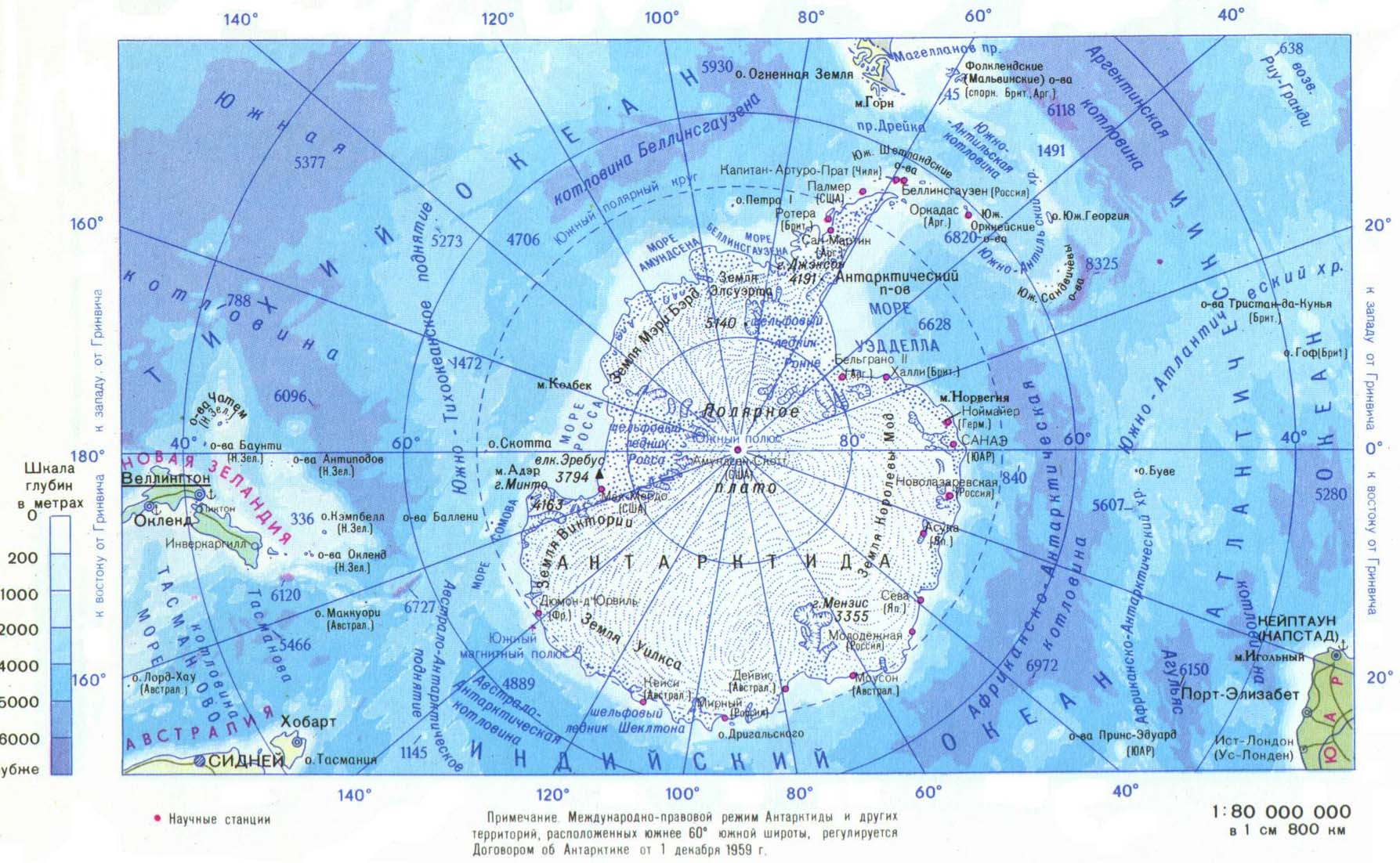
- Baynes, T. S., ed. (1878), , Encyclopædia Britannica, vol. 2 (9th ed.), New York: Charles Scribner's Sons, p. 100
- Chisholm, Hugh, ed. (1911). . دائرة المعارف البريطانية. Vol. 12 (eleventh ed.). Cambridge University Press. p. 422.
{{cite encyclopedia}}: Cite has empty unknown parameter:|coauthors=(help) - Brindley, David, ed. (2014), "Antarctic Ocean, Austral Ocean, Southern Ocean", Style Manual, Washington: National Geographic Society, http://stylemanual.ngs.org/home/A/antarctic-ocean, retrieved on 31 July 2015.
قراءات إضافية
- Arndt, Jan Erik; Schenke, Hans Werner; et al. (2013-06-20). "The International Bathymetric Chart of the Southern Ocean (IBCSO) Version 1.0—A new bathymetric compilation covering circum-Antarctic waters" (PDF). Geophysical Research Letters. American Geophysical Union (AGU). 40 (12): 3111–3117. Bibcode:2013GeoRL..40.3111A. doi:10.1002/grl.50413. ISSN 0094-8276. S2CID 210009232.
- Gille, Sarah T. (2002-02-15). "Warming of the Southern Ocean Since the 1950s". Science. American Association for the Advancement of Science (AAAS). 295 (5558): 1275–1277. Bibcode:2002Sci...295.1275G. doi:10.1126/science.1065863. ISSN 0036-8075. PMID 11847337. S2CID 31434936.
- Tchernia, P. (1980). Descriptive Regional Oceanography. Oxford: Pergamon. ISBN 978-0-08-020919-7.
- Matthias Tomczak and J. Stuart Godfrey. 2003. Regional Oceanography: an Introduction. (see the site)
وصلات خارجية
- The CIA World Factbook's entry on the Southern Ocean
- The Fifth Ocean Archived 6 سبتمبر 2008 at the Wayback Machine from Geography.About.com
- International Hydrographic Organization (IHO): Limits of Oceans and Seas (2nd Edition), extant 1937 to 1953, with limits of Southern Ocean.
- NOAA FAQ about the number of oceans
- Commission for the Conservation of Antarctic Marine Living Resources
| عام |  | |
|---|---|---|
| المناطق الجغرافية | ||
| ممرات مائية | ||
| مشاهير المستكشفين | ||
| مناطق العالم | |||||||||||||||||||||||||
|---|---|---|---|---|---|---|---|---|---|---|---|---|---|---|---|---|---|---|---|---|---|---|---|---|---|
|
| ||||||||||||||||||||||||
| انظر أيضاً قارات العالم | |||||||||||||||||||||||||
- Articles containing فرنسية-language text
- Articles containing ألمانية-language text
- Articles containing صينية-language text
- مقالات المعرفة المحتوية على معلومات من دائرة المعارف البريطانية طبعة 1911
- CS1: Julian–Gregorian uncertainty
- Wikipedia articles incorporating text from the 1911 Encyclopædia Britannica
- CS1 الإستونية-language sources (et)
- CS1 الإنجليزية البريطانية-language sources (en-gb)
- Articles with dead external links from February 2023
- Short description is different from Wikidata
- Articles with hatnote templates targeting a nonexistent page
- Articles containing لاتينية-language text
- Pages using gadget WikiMiniAtlas
- Articles with excerpts
- Wikipedia articles incorporating a citation from EB9
- المحيط الجنوبي
- تضاريس المحيط الجنوبي
- مناطق بيئية بحرية
- محيطات