بحيرة أرومية
| بحيرة أرومية | |
|---|---|
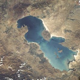 Lake Urmia from space in 1984 | |
| الإحداثيات | 37°42′N 45°22′E / 37.700°N 45.367°E |
| Type | بحيرة فائقة الملوحة |
| الموارد الرئيسية | Zarriné-Rūd, Simineh-Rūd, Mahabad River, Gadar River, Barandouz River, Shahar River, Nazlou River, Zola River, Kaftar Ali Chay, Aji Chay, Boyuk Chay, Rudkhaneh-ye Qal'eh Chay, Qobi Chay, Rudkhaneh-ye Mordaq, Leylan River; diversion from the Zab River |
| التصريفات الرئيسية | none: كل الماء الداخل للبحيرة يـُفقد عبر البخر |
| بلدان الحوض | إيران |
| أقصى طول | 140 كم [1995] |
| أقصى عرض | 55 كم [1995] |
| مساحة السطح | 2917 كم² [2021-april] |
| أقصى عمق | 16 م [1995] |
| حجم المياه | 1.14 كم³ [2013] |
| الملوحة | 217–235 g L−1 Na–(Mg)–Cl–(SO4) brine [20th c.][1] 8–11% in spring, 26–28% in late autumn[2] |
| الجزر | 102 [1995] (انظر القائمة) |
| المراجع | [3] |
| الاسم الرسمي | بحيرة أرومية |
| التوصيف | 23 يونيو 1975 |
| الرقم المرجعي | 38[4] |
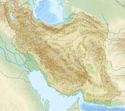
بحيرة أورميا (فارسية: دریاچهٔ ارومیه؛ آذربيجاني: اۇرمۇ گؤلۆ, romanized: Urmu gölü؛ بالأرمينية: Կապուտան؛ ; ancient name: بحيرة Matiene؛ إنگليزية: Lake Urmia)، هي بحيرة مالحة في شمال غرب إيران بالقرب من الحدود الإيرانية التركية.[5][6] تقع البحيرة بين محافظات أذربيجان الشرقية وأذربيجان الغربية في إيران، وغرب المنطقة الجنوبية من بحر قزوين. عند حجمها الكامل، تعتبر أكبر بحيرة في الشرق الأوسط وسادس أكبر بحيرة مالحة على الأرض بمساحة سطح تصل إلى 5.200 كم² تقريباً، وطول يبلغ 140 كم، وعرض 55 كم، وعمق 16 م.[7]
تقع بحيرة أروميا و102 جزيرة ضمن منتزه وطني محمي من وزارة البيئة الإيرانية.
الأسماء وأصولهم
Richard Nelson Frye suggested an Urartian origin for the name[8] while T. Burrow connected the origin of the name Urmia to Indo-Iranian urmi- "wave" and urmya- "undulating, wavy".[9] A more likely etymology would be from Neo-Aramaic Assyrian-Chaldean spoken by the shrinking number of the ancient Christian population of the nearby city of Urmia, consisting of ur meaning "city," and mia meaning "water." Together, the "water city", what Urmia city is: a city on the waters of the eponymous lake.
Locally, the lake is referred to in Persian as Daryāče-ye Orumiye (دریاچهٔ ارومیه), in Azerbaijani as Urmu Gölü, and in Kurdish as Deryaçeya Wirmê. The traditional Armenian name is Kaputan tsov (Կապուտան ծով), literally "blue sea". Residents of Shahi Island refer to the lake in Azerbaijani as Daryā meaning Sea.[10][11][12]
Its Old Persian name was Chichast, meaning "glittering", a reference to the glittering mineral particles suspended in the water of the lake and found along its shores.[بحاجة لمصدر] In medieval times it came to be known as Lake Spauta or Lake Kabuda (Kabodan) in Armenian geography,[13] from the word for "azure" in Persian, or kapuyt ('կապույտ') in Armenian.
الآثار والتاريخ
The Lake Urmia region has a wealth of archaeological sites going back to the Neolithic period. Archaeological excavations of the settlements in the area have found artifacts that date from about 7,000 BCE and later.
Excavations at Teppe Hasanlu archeological site southwest of Lake Urmia also revealed habitations going back to the 6th millennium BCE.
A related site is Yanik Tepe, on the east shore of Lake Urmia, that has been excavated in the 1950s and 60s by C. A. Burney.[14]
Another important site in the area, from about the same era, is Hajji Firuz Tepe, where some of the oldest archaeological evidence of grape-based wine was discovered.
Kul Tepe Jolfa is a site in the Jolfa County about 10 km south from the Araxes River. It dates to Chalcolithic period (5000–4500 BCE).
Se Girdan kurgans are located on the south shore of Lake Urmia. Some of them were excavated in 1968 and 1970 by O. Muscarella. They have now been redated to the second half of the 4th millennium, although originally they were thought to be much younger.[15]
One of the early mentions of Lake Urmia is from Assyrian records of the 9th century BCE. There, in the records from the reign of Shalmaneser III (858–824 BCE), two names are mentioned in the area of Lake Urmia: Parsuwaš (i.e. the Persians) and Matai (i.e. the Mitanni). It is not completely clear whether these referred to places or tribes, or what their relationship was to the subsequent list of personal names and "kings". But the Matai were Medes and linguistically the name Parsuwaš matches the Old Persian word pārsa, an Achaemenid ethnolinguistic designation.[16]
The lake was the center of the Mannaean Kingdom. A potential Mannaean settlement, represented by the ruin mound of Hasanlu, was on the south side of the lake. Mannae was overrun by the Matiani or Matieni, an Iranian people variously identified as Scythian, Saka, Sarmatian, or Cimmerian. It is not clear whether the lake took its name from the people or the people from the lake, but the country came to be called Matiene or Matiane, and gave the lake its Latin name.
The Battle of Urmia was fought near the lake in 1604, during the Ottoman–Safavid War of 1603–1618.
In the last five hundred years the area around Lake Urmia has been home to Azerbaijanis, Kurds, Iranians, Assyrians, and Armenians.
الكيمياء
The main cations in the lake water include Na+, K+, Ca2+, Li+ and Mg2+, while Cl−, SO2−4, HCO−3 are the main anions. The Na+ and Cl− concentration is roughly four times the concentration of natural seawater. Sodium ions are at slightly higher concentration in the south compared to the north of the lake, which could result from the shallower depth in the south, and a higher net evaporation rate.
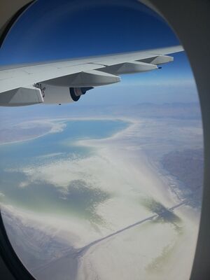
The lake is divided into north and south, separated by the Urmia Lake Bridge and its associated causeway, which was completed in 2008. The bridge provides only a 1.5-كيلومتر (0.93 mi) gap in the embankment, allowing little exchange of water between the two sections. Due to drought and increased demands for agricultural water in the lake's basin, the salinity of the lake has risen to more than 300 g/l during recent years, and large areas of the lake bed have been desiccated.[17]

البيئة
البئة العتيقة
A palynological investigation on long cores from Urmia Lake has revealed a nearly 200 kyr record of vegetation and lake level changes. The vegetation has changed from the Artemisia/grass steppes during the glacial/stadial periods, to oak-juniper steppe-forests during the interglacial/interstadial periods. The lake has had a complex hydrological history and its water levels have fluctuated greatly in geological history. Very high lake levels have been suggested for some time intervals during the two last glacial periods, as well as during both the Last Interglacial as well as the Holocene. The lowest lake levels have occurred during the last glacial periods.

البئة الحديثة
Based on the latest checklists of biodiversity at Lake Urmia in 2014 and 2016, it is home of 62 species of archaebacteria and bacteria, 42 species of microfungi, 20 species of phytoplankton, 311 species of plants, five species of mollusca, 226 species of birds, 27 species of amphibians and reptiles and 24 species of mammals (47 fossils have been recorded in the area).[20][21]
Lake Urmia is an internationally registered protected area as both a UNESCO Biosphere Reserve[19] and a Ramsar site.[22] The Iranian Dept. of Environment has designated most of the lake as a National Park.[23]
The lake is marked by more than a hundred small, rocky islands, which serve as stopover points during the migrations of a number of bird species, including flamingos, pelicans, spoonbills, ibises, storks, shelducks, avocets, stilts, and gulls. A recent drought has significantly decreased the annual amount of water the lake receives. This in turn has increased the salinity of the lake's water, reducing its viability as home to thousands of migratory birds, including a large flamingo populations. The salinity has particularly increased in the half of the lake north of the Urmia Lake Bridge.
By virtue of its high salinity, the lake no longer sustains any fish species. Nonetheless, Urmia Lake is considered a significant natural habitat of Artemia, which serve as food source for the migratory birds such as flamingos.[24] In early 2013, the then-head of the Iranian Artemia Research Center was quoted that Artemia urmiana had gone extinct due to the drastic increases in salinity. However this assessment has been contradicted,[25] and another population of this species has recently been discovered in the Koyashskoye Salt Lake at the Crimean Peninsula.[26]
Falling level and increasing salinity
The lake is a major barrier between Urmia and Tabriz, two of the most important cities in the provinces of West Azerbaijan and East Azerbaijan. A project to build a highway across the lake was initiated in the 1970s but was abandoned after the Iranian Revolution of 1979, leaving a 15 km (9.3 mi) causeway with an unbridged gap. The project was revived in the early 2000s, and was completed in November 2008 with the opening of the 1.5 km (0.93 mi) Urmia Lake Bridge across the remaining gap.[27] The highly saline environment is already heavily rusting the steel on the bridge despite anti-corrosion treatment. Experts have warned that the construction of the causeway and bridge, together with a series of ecological factors, will eventually lead to the drying up of the lake, turning it into a salt marsh, which will adversely affect the climate of the region.

علم الحياة القديمة
الجزر
الأنهار
- Aji Chay
- نهر ألامالو
- Barandouz River
- Gadar River
- Ghaie River
- Leylan River
- Mahabad River
- Nazlou River
- Rozeh River
- Shahar River
- Simineh River
- Zarrineh River
- Zola River
المسيرات البيئية
في الثقافة العامة
انظر أيضاً
المصادر
- ^ خطأ استشهاد: وسم
<ref>غير صحيح؛ لا نص تم توفيره للمراجع المسماةStevens_Djamali - ^ Urmia Lake. 2012. Encyclopædia Britannica Online. Retrieved 14 August 2015, from https://www.britannica.com/EBchecked/topic/619901/Lake-Urmia
- ^ "Lake Urmia's surface increased by over 1500 km²". Tehran Times. April 11, 2021.
- ^ "Lake Urmia [or Orumiyeh]". Ramsar Sites Information Service. Retrieved 25 April 2018.
- ^ Henry, Roger (2003) Synchronized chronology: Rethinking Middle East Antiquity: A Simple Correction to Egyptian Chronology Resolves the Major Problems in Biblical and Greek Archaeology Algora Publishing, New York, p. 138, ISBN 0-87586-191-1
- ^ E. J. Brill's first encyclopaedia of Islam, 1913–1936, vol. 7, page 1037 citing Strabo and Ptolemy.
- ^ "Britanica". Britannica.com. Retrieved 4 September 2011.
- ^ Richard Nelson Frye, The history of ancient Iran, München (1984), 48–49
- ^ The Proto-Indoaryans, by T. Burrow, The Journal of the Royal Asiatic Society of Great Britain and Ireland, No. 2 (1973), pp. 123–140, published by: Cambridge University Press, see 139
- ^ Amurian, A.; Kasheff, M. (15 December 1986). "Armenians of modern Iran". Encyclopædia Iranica. Archived from the original on 26 October 2018. Retrieved 2 May 2016.
Urmia (class. Arm. Kaputan) ...
- ^ Russell, James R. (1987). Zoroastrianism in Armenia. Harvard University. p. 430.
Urmia Lake, called Kaputan cov by Arm. geographers...
- ^ "Armenian Highland". armin.am. Institute for Armenian Studies of Yerevan State University.
In the Armenian Highland there are numerous lakes and ponds. The most majors are Kaputan (Urmia), Van and Sevan.
- ^ See, e.g. the Shahnama.
- ^ C. A. Burney, Excavations at Yanik Tepe, North-West-Iran, Iraq 23, 1961, pp. 138ff.
- ^ O. W. Muscarella, "The Chronology and Culture of Se Girdan: Phase III", Ancient Civilizations from Scythia to Siberia 9/1-2, 2003, pp. 117-31
- ^ cf. Skjærvø, Prods Oktor (2006), "Iran, vi(1). Earliest Evidence", Encyclopaedia Iranica, Vol. 13
- ^ Alireza Asem; Fereidun Mohebbi; Reza Ahmadi (2012). "Drought in Urmia Lake, the largest natural habitat of brine shrimp Artemia" (PDF). World Aquaculture. 43: 36–38. Archived from the original (PDF) on 1 April 2016. Retrieved 17 May 2013.
- ^ "Saline Systems; Urmia Salt Lake, Iran". Salinesystems.org. Retrieved 4 September 2011.
- ^ أ ب "UNESCO Biosphere Reserve Directory".
- ^ Asem, A.; Eimanifar, A.; Djamal, M.; De; Rios, P.; Wink, M. (2014). "Biodiversity of the Hypersaline Urmia Lake National Park (NW Iran)". Diversity. 6: 102–132. doi:10.3390/d6010102.
- ^ Asem, A.; Eimanifar, A.; Wink, M. (2016). ""Update of "Biodiversity of the Hypersaline Urmia Lake National Park (NW Iran)". Diversity. 8 (4): 6. doi:10.3390/d8010006.
- ^ Ramsar Sites Information Service
- ^ "ProtectedPlanet - Urumieh lake". Archived from the original on 23 March 2019. Retrieved 24 March 2015.
- ^ C. Michael Hogan. 2011. Urmia Lake. Eds. P. Saundry & C. J.Cleveland. Encyclopedia of Earth. National Council for Science and the Environment. Washington, D.C.
- ^ Critical condition of Artemia urmiana and possibility of extinction
- ^ Eimanifar A; Asem A; Djamali M; Wink M (2016). "A note on the biogeographical origin of the brine shrimp Artemia urmiana Günther, 1899 from Urmia Lake, Iran". Zootaxa. 4097 (2): 294–300. doi:10.11646/zootaxa.4097.2.12. PMID 27394547. S2CID 25998873.
- ^ "Iran's East and West Azerbaijan Provinces Connected by Lake Orumiyeh Bridge". Payvand.com. Retrieved 4 September 2011.
وصلات خارجية
- Iranica Encyclopedia: Eckhart Ehlers, "Lake Urmia", 2013
- Encyclopedia of Earth: C. Michael Hogan, "Lake Urmia", 2011
- Saline Systems; Urmia Salt Lake, Iran
- Profile at UNESCO Biosphere Reserve Directory
- Lake level fluctuations in the geological history
- Late Pleistocene vegetation changes in NW Iran
- Evaluation of dike-type causeway impacts on the flow and salinity regimes in Urmia Salt Lake, Iran
- Iran's Environmental Ticking Bomb
- www.urmiyalake.blogveb.com
- Iran's Dam Policy and The Case of Lake Urmia by Ercan AYBOGA & Akgün ILHAN
- Panorma picture of Lake Urmia by Armin Jalili
- Tishineh
- [1]
- Aerial view of Lake Urmia
- Pages using gadget WikiMiniAtlas
- Short description is different from Wikidata
- Coordinates on Wikidata
- Articles containing فارسية-language text
- Articles containing آذربيجاني-language text
- Pages using Lang-xx templates
- Articles containing أرمنية-language text
- Articles containing إنگليزية-language text
- Articles with unsourced statements from September 2021
- Articles with hatnote templates targeting a nonexistent page
- بحيرات إيران
- آشور
- محافظة أذربيجان الشرقية
- محافظة أذربيجان الغربية
- محميات المحيط الحيوي في إيران
- مواقع رامسار في إيران
- بحيرات مالحة
- بحيرات سابقة
