مضيق داڤيس
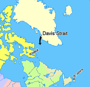
مضيق داڤيس (Davis Strait، فرنسية: Détroit de Davis)، هو الذراع الشمالي من بحر لابرادور. يقع بين الوسط الغربي لگرينلاند ونوناڤوت، جزير بافن الكندية. إلى الشمال منه يقع خليج بافن. سمي المضيق على اسم المستكشف الإنگليزي جون داڤيس (1550–1605)، الذي استكشف المنطقة وهو يسعى إلى الممر الشمالي الغربي. بحلول عقد 1650 كان يستخدم لصيد الحيتان.
الامتداد
الجيولوجيا
تحت مضيق داڤيس العديد من الخصائص الجيولوجية المعقدة مثل الأحواض)، وسلاسل جبلية، التي ربما تشكلت بسبب الضربة المسببة للانزلاق أثناء الزمن الباليوجيني حول ما يُقارب 45 و62 مليون سنة. الحركات التكتونية في بحر لابرادور وجزيرة بافن سببت بأن يصبح المضيق أوسع مضيق في العالم.
العمق
مع وصول العمق في المضيق إلى ما يُقارب ألف وألفين متر, المضيق أضحل من بحر لابرادور إلى الجنوب أو خليج بافن إلى الشمال.
المد والجزر
المضيق مشهور بسبب مده وجزره القويان الذين يمكنهم أن يكونوا ما بين 9.1-18 متر (30-60 قدم)، ما تسبب في تثبيط بعض المستكشفين.
المصادر
قراءات إضافية
- Boertmann, David. Mapping of Oil Spill Sensitive Areas in the Davis Strait, West Greenland A Review of Biological Data in Relation to Oil Spill Sensitivity Mapping, with an Identification of Data Gaps. Copenhagen, Denmark: Greenland Environmental Research Institute, 1992.
- Crawford, R. E. Life History of the Davis Strait Greenland Halibut, with Reference to the Cumberland Sound Fishery. Winnipeg: Dept. of Fisheries and Oceans, 1992.
- Dr̐ưue, C., and G. Heinemann . 2001. "Airborne Investigation Of Arctic Boundary-Layer Fronts Over The Marginal Ice Zone Of The Davis Strait". Boundary-Layer Meteorology. 101, no. 2: 261-292.
- Heide-Jorgensen, M P, H Stern, and K L Laidre. 2007. "Dynamics of the Sea Ice Edge in Davis Strait". Journal of Marine Systems : Journal of the European Association of Marine Sciences and Techniques. 67, no. 1: 170.
- Jones, A G E, and Arthur Credland. 1998. "The Greenland and Davis Strait Trade, 1740-1880". The Polar Record. 34, no. 189: 162.
- J̐ưrgensen, O, C Hvingel, P M̐ưller, and M Treble. 2005. "Identification and Mapping of Bottom Fish Assemblages in Davis Strait and Southern Baffin Bay". Canadian Journal of Fisheries and Aquatic Sciences. 62: 1833-1852.
- Mallory ML, GJ Roberston, and A Moenting. 2006. "Marine Plastic Debris in Northern Fulmars from Davis Strait, Nunavut, Canada". Marine Pollution Bulletin. 52, no. 7: 813-5.
- Ross, W. Gillies. Arctic Whalers, Icy Seas Narratives of the Davis Strait Whale Fishery. Toronto, Canada: Irwin Pub, 1985. ISBN 0-7725-1524-7
وصلات خارجية
- June 2005 Satellite photograph of Davis Strait from MODIS, showing meltwater ponds.

