بيلفلت
Bielefeld | |
|---|---|
| الإحداثيات: 52°01′16″N 08°32′05″E / 52.02111°N 8.53472°E | |
| البلد | ألمانيا |
| الولاية | شمال الراين-وستفاليا |
| Admin. region | Detmold |
| District | Urban district |
| تأسس | 1214 |
| التقسيمات | 10 districts |
| الحكومة | |
| • العمدة | Pit Clausen[1] (SPD) |
| المساحة | |
| • City | 257٫8 كم² (99٫5 ميل²) |
| المنسوب | 118 m (387 ft) |
| التعداد | |
| • Urban | 591٬862 |
| منطقة التوقيت | CET/CEST (UTC+1/+2) |
| Postal codes | 33602–33739 |
| Dialling codes | 0521, 05202, 05203, 05205, 05206, 05208, 05209 |
| لوحة السيارة | BI |
| الموقع الإلكتروني | bielefeld.de |
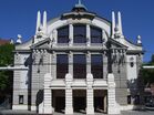
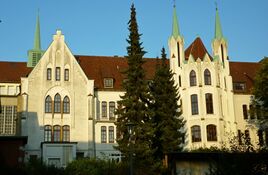
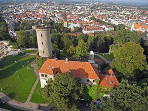
بيلفلت (Bielefeld ؛ ألمانية pronunciation: [ˈbiːləfɛlt] [[:Media:De-Bielefeld.ogg|]] )، هي مدينة في منطقة اوستڤستفالن-ليپه شمال شرق شمال الراين - وستفاليا، ألمانيا. عدد سكانها 341.000 نسمة،[2] وهي أيضاً أكثر المدن اكتظاظاً بالسكان في رگايرونگبزيرك (دتمولد.
يقع المركز التاريخي للمدينة شمال تلال غابة تيوتبورگ، لكن بيلفلت تشمل أيضاً الأحياء الواقعة على الجهة المقابلة وفي التلال. The city is situated on the Hermannsweg, a hiking trail which runs for 156 km along the length of the Teutoburg Forest.[3]
Bielefeld is home to a significant number of internationally operating companies, including Dr. Oetker, DMG Mori (former Gildemeister), Möller Group, Goldbeck and Schüco. It has a university and several technical colleges (Fachhochschulen). Bielefeld is also known for the Bethel Institution.
التاريخ
الرابطة الهانزية القرن 14-
برگ (ولاية) 1346-
Margraviate of Brandenburg 1614-
ميندن-رافنسبرگ 1719–1807
مملكة وستفاليا
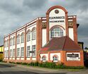
Founded in 1214 by Count Hermann IV of Ravensberg to guard a pass crossing the Teutoburg Forest, Bielefeld was the "city of linen" as a minor member of the Hanseatic League, known for bleachfields into the 19th century.[4] Bielefeld was part of the Kingdom of Westphalia when it was created in 1807.[5] In 1815 it was incorporated into the Kingdom of Prussia following the defeat of France and the Congress of Vienna.[6]
After the Cologne-Minden railway opened in 1849, the Bozi brothers constructed the first large mechanised spinning mill in 1851. The Ravensberg Spinning Mill was built from 1854 to 1857, and metal works began to open in the 1860s.[بحاجة لمصدر]
Founded in 1867 as a Bielefeld sewing machine repair company, Dürkoppwerke AG employed 1,665 people in 1892; it used Waffenamt code "WaA547" from 1938 to 1939 as the Dürkopp-Werke, and merged with other Bielefeld companies to form Dürkopp Adler AG in 1990.[بحاجة لمصدر]
Between 1904 and 1930, Bielefeld grew, opening a rebuilt railway station, a municipal theatre, and finally, the Rudolf-Oetker-Halle concert hall, renowned for its excellent acoustics.[7] The Dürkopp car was produced 1898–1927. After printing emergency money (ألمانية: Notgeld) in 1923 during the inflation in the Weimar Republic, Bielefeld was one of several towns that printed very attractive and highly collectable banknotes with designs on silk, linen and velvet. These pieces were issued by the Bielefeld Stadtsparkasse (town's savings bank) and were sent all around the world in the early 1920s. These pieces are known as Stoffgeld – that is, money made from fabric.[8]
The town's synagogue was burned in 1938 during the Kristallnacht pogrom carried out against Jewish population. In 1944, Boeing B-17 Flying Fortresses of the USAAF bombed the gas works at Bielefeld on 20 September[9] and the marshaling yard on 30 September;[10] Bielefeld was bombed again on 7 October[11] and the RAF bombed the town on the night of 4/5 December.[12] On 17 January 1945, B-17s bombed the nearby Paderborn marshalling yard, and the railway viaduct in the suburb of Schildesche.[13] On 14 March the RAF bombed the viaduct again, wrecking it. This was the first use of the RAF's 10 tonne Grand Slam bomb. American troops entered the city in April 1945.[بحاجة لمصدر]
Due to the presence of a number of barracks built during the 1930s and its location next to the main East-West Autobahn in northern Germany, after World War II Bielefeld became a headquarters town for the fighting command of the British Army of the Rhine – BAOR (the administrative and strategic headquarters were at Rheindahlen near the Dutch border). Until the 1980s there was a large British presence in the barracks housing the headquarters of the British First Corps and support units, as well as schools, NAAFI shops, officers' and sergeants' messes and several estates of married quarters. The British presence was heavily scaled back after the reunification of Germany and most of the infrastructure has disappeared.[بحاجة لمصدر]
In 1973 the first villages on the south side of the Teutoburg Forest were incorporated.[بحاجة لمصدر]
Starting in 1994, the city has been featured in the humorous Bielefeld conspiracy which satirises conspiracy theories by claiming that the city does not exist.
Subdivisions
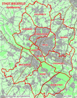
Bielefeld is subdivided into the following ten (10) districts:
- Bielefeld-Mitte (downtown)
- Brackwede
- Dornberg
- Gadderbaum
- Heepen
- Jöllenbeck
- Schildesche
- Senne
- Sennestadt
- Stieghorst
الجغرافيا
المناخ
Bielefeld has an oceanic climate (Köppen: Cfb; Trewartha: Dobk). The average annual high temperature is 14.6 °C (58.3 °F), the annual low temperature is 5.4 °C (41.7 °F), and the annual precipitation is 866.4 ميليمتر (34.11 بوصات).
The Alzey weather station has recorded the following extreme values:[14]
- Its highest temperature was 39.0 °C (102.2 °F) on 25 July 2019.
- Its lowest temperature was −21.3 °C (−6.3 °F) on 13 February 2021.
- Its greatest annual precipitation was 1،466.2 mm (57.72 in) in 2023.
- Its least annual precipitation was 652.6 mm (25.69 in) in 2018.
- The longest annual sunshine was 1,918.3 hours in 2022.
- The shortest annual sunshine was 1,418.4 hours in 2013.
| بيانات المناخ لـ Bielefeld (1991–2020 normals, extremes 2006–present) | |||||||||||||
|---|---|---|---|---|---|---|---|---|---|---|---|---|---|
| الشهر | ينا | فب | مار | أبر | ماي | يون | يول | أغس | سبت | أكت | نوف | ديس | السنة |
| القصوى القياسية °س (°ف) | 16.4 (61.5) |
19.2 (66.6) |
24.5 (76.1) |
27.4 (81.3) |
30.1 (86.2) |
34.7 (94.5) |
39.0 (102.2) |
36.9 (98.4) |
33.3 (91.9) |
27.2 (81.0) |
20.0 (68.0) |
17.4 (63.3) |
39.0 (102.2) |
| متوسط القصوى اليومية °س (°ف) | 4.9 (40.8) |
6.0 (42.8) |
9.9 (49.8) |
15.5 (59.9) |
18.7 (65.7) |
22.1 (71.8) |
24.3 (75.7) |
24.0 (75.2) |
19.8 (67.6) |
14.5 (58.1) |
9.3 (48.7) |
6.1 (43.0) |
14.6 (58.3) |
| المتوسط اليومي °س (°ف) | 2.6 (36.7) |
2.9 (37.2) |
5.6 (42.1) |
9.8 (49.6) |
13.0 (55.4) |
16.4 (61.5) |
18.2 (64.8) |
18.0 (64.4) |
14.3 (57.7) |
10.5 (50.9) |
6.5 (43.7) |
3.9 (39.0) |
10.1 (50.2) |
| متوسط الدنيا اليومية °س (°ف) | −0.1 (31.8) |
−0.2 (31.6) |
1.2 (34.2) |
3.5 (38.3) |
6.6 (43.9) |
10.3 (50.5) |
11.9 (53.4) |
12.0 (53.6) |
9.0 (48.2) |
6.6 (43.9) |
3.5 (38.3) |
1.3 (34.3) |
5.4 (41.7) |
| متوسط الدنيا °س (°ف) | −8.9 (16.0) |
−7.5 (18.5) |
−5.0 (23.0) |
−2.6 (27.3) |
0.0 (32.0) |
4.8 (40.6) |
6.5 (43.7) |
6.7 (44.1) |
2.8 (37.0) |
−0.4 (31.3) |
−3.7 (25.3) |
−6.2 (20.8) |
−11.1 (12.0) |
| الصغرى القياسية °س (°ف) | −20.2 (−4.4) |
−21.3 (−6.3) |
−14.7 (5.5) |
−5.6 (21.9) |
−1.5 (29.3) |
0.8 (33.4) |
4.7 (40.5) |
5.2 (41.4) |
−0.3 (31.5) |
−4.4 (24.1) |
−9.1 (15.6) |
−20.0 (−4.0) |
−21.3 (−6.3) |
| متوسط تساقط الأمطار mm (inches) | 101.5 (4.00) |
69.3 (2.73) |
62.9 (2.48) |
35.2 (1.39) |
64.7 (2.55) |
71.5 (2.81) |
72.7 (2.86) |
83.0 (3.27) |
60.1 (2.37) |
70.7 (2.78) |
78.2 (3.08) |
96.7 (3.81) |
866.4 (34.11) |
| متوسط عمق الثلج الكثيف cm (inches) | 5.8 (2.3) |
2.7 (1.1) |
1.3 (0.5) |
0 (0) |
0 (0) |
0 (0) |
0 (0) |
0 (0) |
0 (0) |
0 (0) |
0.9 (0.4) |
4.9 (1.9) |
8.8 (3.5) |
| Average precipitation days (≥ 0.1 mm) | 20.8 | 16.7 | 15.7 | 12.1 | 14.3 | 14.6 | 16.7 | 16.5 | 14.0 | 16.7 | 18.6 | 21.6 | 198.3 |
| متوسط الرطوبة النسبية (%) | 87.1 | 82.8 | 77.5 | 72.3 | 74.0 | 75.6 | 74.1 | 75.5 | 80.8 | 85.3 | 87.9 | 87.7 | 80.0 |
| Mean monthly ساعات سطوع الشمس | 40.8 | 69.2 | 134.0 | 181.6 | 217.9 | 216.1 | 220.1 | 200.4 | 149.0 | 100.5 | 54.0 | 33.8 | 1٬617٫3 |
| Source: Deutscher Wetterdienst / SKlima.de[14] | |||||||||||||
الديموغرافيا
| أكبر مجموعات المقيمين الأجانب[15] | |
| الجنسية | السكان (2014) |
|---|---|
| 11,864 | |
| 3,398 | |
| 2,952 | |
| 2,873 | |
| 2,587 | |
| 1,271 | |
| 1,140 | |
| 924 | |
الصناعة والتعليم
Bielefeld was a linen-producing town, and in the early 1920s the Town's Savings Bank (Stadtsparkasse) issued money made of linen, silk and velvet. These items were known as 'stoffgeld'.
In addition to the manufacture of home appliances and various heavy industries, Bielefeld companies include Dr. Oetker (food manufacturing), Möller Group (leather products and plastics), Seidensticker (clothing and textiles) and Bethel Institution with 17.000 employees.
Bielefeld University was founded in 1969. The first professors included the well-known German sociologist Niklas Luhmann. Other institutions of higher education include the Theological Seminary Bethel (Kirchliche Hochschule Bethel) and the Bielefeld University of Applied Sciences (ألمانية: Hochschule Bielefeld), which offers 21 courses in 8 different departments (agriculture and engineering are in Minden) and has been internationally recognized for its photography school.[16] Bielefeld has several vocational schools like Berufskolleg Senne.[17] and Berufskolleg Bethel[18] These schools focus on hands-on training in various fields, including business, healthcare, and technical disciplines.
المعالم الرئيسية
مشاهير المدينة
- Friedrich von Bodelschwingh, Senior (1831–1910), Second boss of the "Evangelischen Heil- und Pflegeanstalt für Epileptische" (Evangelic Sanatorium for Epileptics) (1874 renamed into "Bethel")
- Birthplace of Friedrich von Bodelschwingh, Junior (1877–1946), Third boss of the von Bodelschwinghsche Anstalten, named after F. v. Bodelschwingh, the Older (Later renamed into von Bodelschwinghsche Stiftungen)
- Birthplace of Friedrich Wilhelm Murnau (1888–1931), film director
- Birthplace of Kevin John Edusei, music director of the Münchner Symphoniker
- Birthplace of Klaus Hildebrand (* 1941), historian
- Birthplace of Hannes Wader (* 1942), political Singer-songwriter ("Liedermacher")
- Birthplace of Aleida Assmann (* 1947), professor of English, Egyptology, Literary and Cultural Studies
- Birthplace of Michael Diekmann (* 1953), Chief Executive Officer, Allianz
- Birthplace of Rolf Kanies (* 1957), German actor
- Birthplace of Lena Goeßling (* 1986-), women's association football player for Germany women's national football team and VfL Wolfsburg (women)
- Hometown of (Rosie Jacobs) (*1996), German drummer
- Birthplace of Julius Delius (* 1822–1901) and his wife Elise Pauline, née Krönig (* 1838–1929), the parents of Frederick Delius (* 1862-1934).
- Hometown of Aylin Tezel (*1983), German actress
العلاقات الدولية
بيلفلت على توأمة مع:
المصادر
- ^ Wahlergebnisse in NRW Kommunalwahlen 2020, Land Nordrhein-Westfalen, accessed 19 June 2021.
- ^ "Aktuelle Einwohnerzahlen". Bielefeld.de. 31 December 2021. Retrieved 8 February 2022.
- ^ "Hiking in NRW: Hermannsweg". Retrieved 5 July 2020.
- ^ Hamburgh Mail, The Times 14 December 1816
- ^ The Times, 9 November 1809; Letters to the Editor
- ^ The Times, 26 August 1815; News
- ^ "Bielefeld – History". Bielefeld.de. Archived from the original on 27 April 2009. Retrieved 5 May 2009.
- ^ Many examples can be found on the "Archived copy". Archived from the original on 10 October 2016. Retrieved 15 April 2010.
{{cite web}}: CS1 maint: archived copy as title (link) website, where a new catalogue listing all the variants of different coloured borders and edges made on the 100m piece is being compiled. - ^ "Veterans History Project". Central Connecticut State University. 24 February 2005. Retrieved 7 April 2011.
- ^ McKillop, Jack. "Combat Chronology of the USAAF". USAAF. Archived from the original on 10 June 2007. Retrieved 25 May 2007.September 1944
- ^ McKillop, October 1944
- ^ "War Diary December 1944". Bomber Command 60th Anniversary. Raf.mod.uk. Archived from the original on 6 June 2011. Retrieved 7 April 2011.
- ^ McKillop, January 1945
- ^ أ ب "Monatsauswertung". sklima.de (in الألمانية). SKlima. Retrieved 20 October 2024.
- ^ "Statistische Kurzinformation Bielefeld Bevölkerung in den Stadtbezirken" (PDF). Bielefeld - Amt für Demographie und Statistik. Retrieved 2014-07-25.
- ^ "University of Applied Sciences Bielefeld". Archived from the original on 14 September 2009. Retrieved 23 October 2009.
- ^ "Berufskolleg Senne". Retrieved 15 November 2024.
- ^ "Infotag am Berufskolleg Bethel". Retrieved 15 November 2024.
- ^ "Serwis informacyjny UM Rzeszów - Informacja o współpracy Rzeszowa z miastami partnerskimi". www.rzeszow.pl. Retrieved 2010-02-02.[dead link]
وصلات خارجية
| Bielefeld, Germany Live webcam |
 وسائط متعلقة بـBielefeld من مشاع المعرفة.
- Pages using gadget WikiMiniAtlas
- CS1 الألمانية-language sources (de)
- Articles with dead external links from September 2010
- Short description is different from Wikidata
- Pages using multiple image with auto scaled images
- Coordinates on Wikidata
- Germany articles requiring maintenance
- Pages using infobox German location with unknown parameters
- Towns in North Rhine-Westphalia
- Pages with ألمانية IPA
- Pages including recorded pronunciations
- Articles containing ألمانية-language text
- Articles with unsourced statements from August 2022
- Articles with hatnote templates targeting a nonexistent page
- بيلفلت
- Province of Westphalia
- Members of the Hanseatic League
- Urban districts of North Rhine-Westphalia
- Detmold (region)

