جمهورية أوكرانيا الاشتراكية السوڤيتية
| ||||||||||||||||||||||||||||||||||||||||||||||||||||||||||||||||||||||||||||||||||||||||||
| ||||||||||||||||||||||||||||||||||||||||||||||||||||||||||||||||||||||||||||||||||||||||||
جمهورية أوكرانيا الاشتراكية السوڤيتية (Ukrainian SSR or UkSSR; أوكرانية: Украї́нська Радя́нська Соціалісти́чна Респу́бліка, Украї́нська РСР; روسية: Украи́нская Сове́тская Социалисти́ческая Респу́блика, Украи́нская ССР; see "Name" section below), commonly referred to as Soviet Ukraine or simply known as Ukraine[بحاجة لمصدر], was a Soviet socialist state[6] and one of the constituent republics of the Soviet Union from its inception in 1922 to its breakup in 1991.
The Ukrainian SSR was a founding member of the United Nations,[7] although it was legally represented by the All-Union state in its affairs with countries outside of the Soviet Union. Upon the Soviet Union's dissolution and perestroika, the Ukrainian SSR was transformed into the modern nation-state and renamed itself to the Republic of Ukraine, although Ukraine's new constitution was only ratified on 28 June 1996.
Throughout its 72-year history, the republic's borders changed many times, with a significant portion of what is now Western Ukraine being annexed by Soviet forces in 1939 from the Republic of Poland, and the addition of Russian Crimea in 1954. From the start, the eastern city of Kharkiv served as the republic's capital. However, in 1934, the seat of government was subsequently moved to the city of Kiev, which remained the capital of newly independent Ukraine.
Geographically, the Ukrainian SSR was situated in Eastern Europe to the north of the Black Sea, bordered by the Soviet republics of Moldavia, Byelorussia, and the Russian SFSR. The Ukrainian SSR's border with Czechoslovakia formed the Soviet Union's western-most border point. According to the Soviet Census of 1989 the republic had a population of 51,706,746 inhabitants, which fell sharply after the breakup of the Soviet Union.
الاسم
التاريخ
التأسيس: 1917–1922
سنوات ما بين الحربين: 1922–1939


خروشوڤ وبريجنيڤ: 1953–1985
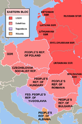
| الكتلة الشرقية |
|---|
 |
گورباتشوڤ والحل: 1985–1991

التقسيمات الادارية

الاقتصاد

الزراعة
الصناعة

الدين
 مقالة مفصلة: الدين في الاتحاد السوڤيتي
العمران

الهامش
- ملاحظات
- ذِكر
- ^ "History" (in Ukrainian). Kharkiv Oblast Government Administration. Retrieved 16 April 2011.
{{cite web}}: CS1 maint: unrecognized language (link) - ^ Soviet Encyclopedia of the History of Ukraine (in Ukrainian). Academy of Sciences of the Ukrainian SSR. 1969–1972.
{{cite book}}: CS1 maint: unrecognized language (link) - ^ Law of Ukraine "About languages of the Ukrainian SSR"
- ^ Language Policy in the Soviet Union by Lenore Grenoble, Springer Science+Business Media, 2003, ISBN 978-1-4020-1298-3.
- ^ History of Ukraine - The Land and Its Peoples by Paul Robert Magocsi, University of Toronto Press, 2010, ISBN 1442640855
- ^ Article 68, Constitution of Ukraine 1978
- ^ "Activities of the Member States - Ukraine". United Nations. Retrieved 2011-01-17.
- ببليوگرافيا
- Magocsi, Paul R. (1996). A History of Ukraine. Toronto: University of Toronto Press. ISBN 0-8020-0830-5.
- Adams, Arthur E. Bolsheviks in the Ukraine: The Second Campaign, 1918—1919 (New Haven & London: Yale University Press, 1963).
- Armstrong, John A. The Soviet Bureaucratic Elite: A Case Study of the Ukrainian Apparatus (New York: Praeger, 1959).
- Dmytryshyn, Basil. Moscow and the Ukraine, 1918—1953: A Study of Russian Bolshevik Nationality Policy (New York: Bookman Associates, 1956).
- Manning, Clarence A. Ukraine under the Soviets (New York: Bookman Associates, 1953).
- Sullivant, Robert S. Soviet Politics and the Ukraine, 1917—1957 (New York: Columbia University Press, 1962).
وصلات خارجية
- "Governments of the Ukrainian Soviet Socialist Republic". Government portal. Retrieved 2008-06-11.
- "Constitution of the Ukrainian Soviet Socialist Republic". Verkhovna Rada of Ukraine (in Ukrainian). 1978. Retrieved 2008-06-11.
{{cite web}}: CS1 maint: unrecognized language (link)
- Pages using gadget WikiMiniAtlas
- Pages using infobox country with unknown parameters
- Pages using infobox country or infobox former country with the flag caption or type parameters
- Pages using infobox country or infobox former country with the symbol caption or type parameters
- Portal-inline template with redlinked portals
- Pages with empty portal template
- Articles containing أوكرانية-language text
- Pages using Lang-xx templates
- Articles containing روسية-language text
- Articles with unsourced statements from October 2016
- Articles with hatnote templates targeting a nonexistent page
- Coordinates on Wikidata
- جمهورية أوكرانيا الاشتراكية السوڤيتية
- جمهوريات الاتحاد السوڤيتي
- الشيوعية في أوكرانيا
- دول شيوعية
- جمهوريات اشتراكية سابقة
- تاريخ أوكرانيا (1918–91)
- Modern history of Ukraine
- الكتلة الشرقية
- بلدان سابقة في اوروبا
- دول أعضاء سابقون في الأمم المتحدة
- بلدان سلاڤية سابقة
- Post–Russian Empire states
- الثورة الروسية في أوكرانيا
- Russian-speaking countries and territories
- Ukrainian-speaking countries and territories
- تأسيسات 1919 في أزكرانيا
- 1991 disestablishments in Ukraine
- دول وأقاليم تأسست في 1919
- دول وأقاليم تأسست في 1996
- States and territories disestablished in 1991
- States and territories disestablished in 1996
- القرن العشرين في أوكرانيا
- العلاقات الأوكرانية السوڤيتية


