لو مان
Le Mans | |
|---|---|
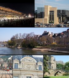
 Top row: left, Le Mans 24-hr automobile race in June; right, Le Mans Justice Department Office; Middle row: View of Sarthe River and historic area, including the Palais of Comtes du Maine; Bottom row: left, Le Mans Tramway in Gambetta Street; center, Facade built in Le Mans Commerce Center; right, Saint Julien Cathedral | |
أظهر Location of Le Mans | |
| البلد | فرنسا |
| المنطقة | بلاد اللوار |
| الإقليم | سارت |
| الدائرة | Le Mans |
| بينالتجمعات | Le Mans |
| الحكومة | |
| • العمدة (2001–2008) | Jean-Claude Boulard |
| المساحة 1 | 52٫81 كم² (20٫39 ميل²) |
| التعداد (2006) | 148٬169 |
| • الكثافة | 2٬800/km2 (7٬300/sq mi) |
| منطقة التوقيت | UTC+01:00 (CET) |
| • الصيف (التوقيت الصيفي) | UTC+02:00 (CEST) |
| INSEE/الرمز البريدي | 72181 /72000 |
| Dialling codes | (0)243 |
| المنسوب | 38–134 m (125–440 ft) (avg. 51 m أو 167 ft) |
| 1 French Land Register data, which excludes lakes, ponds, glaciers > 1 km2 (0.386 sq mi or 247 acres) and river estuaries. | |
Le Mans (تـُنطق: [lə mɑ̃]) هي مدينة في فرنسا، تقع على نهر سارت. Traditionally the capital of the province of Maine, it is now the capital of the Sarthe department and the seat of the Roman Catholic diocese of Le Mans. Le Mans is a part of the Pays de la Loire region.
Its inhabitants are called Manceaux and Mancelles. Since 1923, the city has hosted the internationally famous 24 Hours of Le Mans endurance sports car race.
التاريخ

المناخ
| أخفبيانات المناخ لـ لو مان (1981–2010 averages) | |||||||||||||
|---|---|---|---|---|---|---|---|---|---|---|---|---|---|
| الشهر | ينا | فب | مار | أبر | ماي | يون | يول | أغس | سبت | أكت | نوف | ديس | السنة |
| القصوى القياسية °س (°ف) | 17.2 (63.0) |
21.0 (69.8) |
24.9 (76.8) |
30.3 (86.5) |
32.4 (90.3) |
37.1 (98.8) |
40.4 (104.7) |
40.5 (104.9) |
34.6 (94.3) |
30.0 (86.0) |
22.2 (72.0) |
18.3 (64.9) |
40.5 (104.9) |
| متوسط القصوى اليومية °س (°ف) | 7.9 (46.2) |
9.1 (48.4) |
12.7 (54.9) |
15.7 (60.3) |
19.5 (67.1) |
23.1 (73.6) |
25.5 (77.9) |
25.4 (77.7) |
21.9 (71.4) |
17.0 (62.6) |
11.4 (52.5) |
8.2 (46.8) |
16.5 (61.7) |
| متوسط الدنيا اليومية °س (°ف) | 2.1 (35.8) |
1.8 (35.2) |
3.7 (38.7) |
5.6 (42.1) |
9.4 (48.9) |
12.4 (54.3) |
14.2 (57.6) |
13.8 (56.8) |
11.0 (51.8) |
8.6 (47.5) |
4.7 (40.5) |
2.5 (36.5) |
7.5 (45.5) |
| الصغرى القياسية °س (°ف) | −15.2 (4.6) |
−17.0 (1.4) |
−11.3 (11.7) |
−4.9 (23.2) |
−3.7 (25.3) |
1.6 (34.9) |
3.9 (39.0) |
3.2 (37.8) |
−0.5 (31.1) |
−5.4 (22.3) |
−12.0 (10.4) |
−21.0 (−5.8) |
−21.0 (−5.8) |
| متوسط تساقط الأمطار mm (inches) | 67.2 (2.65) |
50.9 (2.00) |
54.3 (2.14) |
53.9 (2.12) |
63.0 (2.48) |
46.9 (1.85) |
56.8 (2.24) |
42.7 (1.68) |
52.9 (2.08) |
66.0 (2.60) |
62.7 (2.47) |
70.2 (2.76) |
687.5 (27.07) |
| Average precipitation days | 11.2 | 9.3 | 10.2 | 9.5 | 10.0 | 7.3 | 7.6 | 6.5 | 8.0 | 10.7 | 10.5 | 11.8 | 112.6 |
| متوسط الرطوبة النسبية (%) | 87 | 83 | 78 | 74 | 75 | 73 | 72 | 74 | 79 | 86 | 88 | 88 | 79.8 |
| Mean monthly ساعات سطوع الشمس | 66.2 | 89.7 | 134.3 | 170.9 | 199.7 | 224.1 | 227.4 | 224.9 | 181.0 | 118.8 | 70.9 | 63.9 | 1٬771٫8 |
| Source 1: Meteo France[1][2] | |||||||||||||
| Source 2: Infoclimat.fr (humidity, snowy days 1961–1990)[3] | |||||||||||||
السكان
At the 1999 French census, there were 293,159 inhabitants in the metropolitan area (aire urbaine) of Le Mans, with 146,105 of these living in the city proper (commune).
| السنة | تعداد | ±% p.a. |
|---|---|---|
| 1962 | 132٬181 | — |
| 1968 | 143٬246 | +1.35% |
| 1975 | 152٬285 | +0.88% |
| 1982 | 147٬697 | −0.44% |
| 1990 | 145٬502 | −0.19% |
| 1999 | 146٬105 | +0.05% |
| 2006 | 148٬169 | +0.20% |
| Source: http://www.insee.fr/fr/ffc/docs_ffc/psdc.htm | ||
العلاقات الدولية
البلدات التوأم والمدن الشقيقة
Le Mans is twinned with:
|
المأكل
The culinary specialty of Le Mans is rillettes, a shredded pork pâté.
المعالم
Located at Mayet near Le Mans, the Le Mans-Mayet transmitter has a height of 342 m and is one of the tallest radio masts in France.
تمثيلها في الثقافة الشعبية
- Le Mans has been a setting for numerous feature films that feature its famous race.
انظر أيضاً
الهامش
- ^ "Données climatiques de la station de Le Mans" (in French). Meteo France. Retrieved January 9, 2016.
{{cite web}}: CS1 maint: unrecognized language (link) - ^ "Climat Pays de la Loire" (in French). Meteo France. Retrieved January 9, 2016.
{{cite web}}: CS1 maint: unrecognized language (link) - ^ "Normes et records 1961-1990: Le Mans - Arnage (72) - altitude 51m" (in French). Infoclimat. Retrieved January 9, 2016.
{{cite web}}: CS1 maint: unrecognized language (link) - ^ "British towns twinned with French towns". Archant Community Media Ltd. Retrieved 2013-07-11.
- ^ Town Twinning, bolton.gov.uk, http://www.bolton.gov.uk/website/pages/Towntwinning.aspx?bid=3515, retrieved on 22 January 2010
- ^ رسمياً منذ 1967، وتقليدياً منذ 836 (أقدم شراكة من نوعها).
- ^ Lelièvre, Jean; Balavoine, Maurice (1994). Le Mans-Paderborn, 836-1994: dans l'Europe, une amitié séculaire, un sillage de lumière. Le Mans: M. Balavoine. pp. 1–42. Retrieved 9 August 2013.
- ^ "The Origins of Town Twinning" (PDF). Inverness: The City of Inverness Town Twinning Committee. 8 December 2008. Retrieved 2009-10-30.
- ^ "Twinnings" (PDF). Central Union of Municipalities & Communities of Greece. Retrieved 2013-08-25.
وصلات خارجية
- Official website Français : قالب:Description/i18n
- Le Mans d'Antan Français : قالب:Description/i18n
- Articles with hatnote templates targeting a nonexistent page
- Missing redirects
- Short description is different from Wikidata
- Pages using infobox settlement with image map1 but not image map
- Pages using infobox settlement with no coordinates
- Pages using infobox French commune with unknown parameters
- France articles requiring maintenance
- Language templates with no text displayed
- Le Mans
- Communes of Sarthe
- أقسام فرنسا
- Roman towns and cities in France
- صفحات مع الخرائط

