نيم
أظهر هذا المقال قد يـُنمّى بنص مترجـَم من المقالة المناظرة في French. (July 2014) انقر [أظهـِر] للتعليمات الهامة للترجمة. |
Nîmes
Nimes (أوكسيتان) | |
|---|---|
Prefecture and commune | |
|
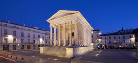
From top to bottom, left to right: city view from Tour Magne, Fontaine Pradier, Arena of Nîmes and Maison Carrée at night | |
أظهر Location of Nîmes | |
| الإحداثيات: 43°50′17″N 4°21′40″E / 43.838°N 4.361°E | |
| البلد | فرنسا |
| المنطقة | أوكسيتاني |
| الإقليم | Gard |
| الدائرة | Nîmes |
| الكانتون | Nîmes-1, 2, 3 and 4 and Saint-Gilles |
| بينالتجمعات | CA Nîmes Métropole |
| الحكومة | |
| • العمدة (2020–2026) | Jean-Paul Fournier[1] (LR) |
| المساحة 1 | 161٫85 كم² (62٫49 ميل²) |
| التعداد (يناير 2019) | 148٬561 |
| • الكثافة | 920/km2 (2٬400/sq mi) |
| منطقة التوقيت | UTC+01:00 (CET) |
| • الصيف (التوقيت الصيفي) | UTC+02:00 (CEST) |
| INSEE/الرمز البريدي | 30189 /30000 and 30900 |
| المنسوب | 21–215 m (69–705 ft) (avg. 39 m or 128 ft) |
| 1 French Land Register data, which excludes lakes, ponds, glaciers > 1 km2 (0.386 sq mi or 247 acres) and river estuaries. | |
نيم ( /niːm/; بالفرنسية: [nim] هي مدينة فرنسية وعاصمة إقليم گار بمنطقة أوكسيتاني في جنوب فرنسا. Located between the Mediterranean Sea and Cévennes. يبلغ عدد سكانها 150,610 نسمة (2017).[2]
Dubbed the most Roman city outside Italy,[3] Nîmes has a rich history dating back to the Roman Empire when the city was a regional capital, and home to 50,000–60,000 people.[4][5][6][7] Several famous monuments are in Nîmes, such as the Arena of Nîmes and the Maison Carrée. Because of this, Nîmes is often referred to as the French Rome.
التاريخ
4000–2000 ق.م.
The Neolithic site of Serre Paradis reveals the presence of semi-nomadic cultivators in the period 4000 to 3500 BCE on the site of Nîmes.[بحاجة لمصدر]
The menhir of Courbessac (or La Poudrière) stands in a field, near the airstrip. This limestone monolith of over two metres in height dates to about 2500 BCE, and is considered the oldest monument of Nîmes.
1800–600 ق.م.
The Bronze Age has left traces of villages that were made out of huts and branches.[بحاجة لمصدر] The population of the site increased during the Bronze Age.
600–121 ق.م.
The hill of Mt. Cavalier was the site of the early oppidum which gave birth to the city. During the third and 2nd centuries BCE a surrounding wall was built with a dry-stone tower at the summit which was later incorporated into the Tour Magne. The Volcae Arecomici people settled around the spring at the foot of Mount Cavalier and built a sanctuary to Nemausus there.
The Warrior of Grezan is considered to be the most ancient indigenous sculpture in southern Gaul.[بحاجة لمصدر]
In 123 BCE the Roman general Quintus Fabius Maximus campaigned against Gallic tribes in the area and defeated the Allobroges and the Arverni, while the Volcae offered no resistance. The Roman province Gallia Transalpina was established in 121 BCE[8] and from 118 BCE the Via Domitia was built through the later site of the city.
العصر الروماني
The city arose on the important Via Domitia which connected Italy with Hispania.
المدن الشقيقة
نيم متوأمة مع:
|
انظر أيضاً
المراجع
- ^ "Répertoire national des élus: les maires". data.gouv.fr, Plateforme ouverte des données publiques françaises (in الفرنسية). 2 ديسمبر 2020. Retrieved 11 ديسمبر 2020.
- ^ Téléchargement du fichier d'ensemble des populations légales en 2017, INSEE
- ^ "Nîmes, the most Roman city outside Italy, just got more Roman". The Telegraph. Retrieved 30 يوليو 2018.
- ^ Frank Sear (1983). Roman Architecture. Cornell University Press. p. 213. ISBN 0-8014-9245-9.
- ^ Trudy Ring; Noelle Watson; Paul Schellinger (28 أكتوبر 2013). Northern Europe: International Dictionary of Historic Places. Taylor & Francis. p. 853. ISBN 978-1-136-63951-7.
- ^ "Archived copy" (PDF). Archived from the original (PDF) on 26 مارس 2014. Retrieved 19 مارس 2014.
{{cite web}}: CS1 maint: archived copy as title (link) - ^ MobileReference (1 يناير 2007). Travel Barcelona, Spain for Smartphones and Mobile Devices – City Guide, Phrasebook, and Maps. MobileReference. p. 428. ISBN 978-1-60501-059-5.
- ^ Maddison, Angus (2007), Contours of the World Economy 1–2030 AD: Essays in Macro-Economic History, Oxford: Oxford University Press, p. 41, ISBN 9780191647581
- ^ "British towns twinned with French towns". Archant Community Media Ltd. Retrieved 11 يوليو 2013.
- ^ "Braunschweigs Partner und Freundschaftsstädte". Stadt Braunschweig [City of Braunschweig] (in German). Archived from the original on 1 ديسمبر 2012. Retrieved 7 أغسطس 2013.
{{cite web}}: Unknown parameter|trans_title=ignored (|trans-title=suggested) (help)CS1 maint: unrecognized language (link)
وصلات خارجية
- 2° Régiment étranger d'infanterie
- Practical Guide to Nîmes Airport
- City council website
- The official Web site of Roman Nîmes
- Images of Roman remains of Nîmes
- Photogallery of Nîmes
- Photos & Map of Nîmes
- Regordane Info – The independent portal for The Regordane Way or St Gilles Trail The Regordane passes through Nîmes. (in English and French)
- Pages using gadget WikiMiniAtlas
- CS1 الفرنسية-language sources (fr)
- CS1 errors: unsupported parameter
- Short description is different from Wikidata
- Use dmy dates from May 2020
- Articles containing أوكسيتان (بعد 1500)-language text
- Coordinates on Wikidata
- Pages using infobox settlement with image map1 but not image map
- Articles with unsourced statements from May 2020
- Articles with unsourced statements from October 2008
- Articles with hatnote templates targeting a nonexistent page
- نيم
- Communes of Gard
- أقسام فرنسا
- مدن فرنسا
- مستعمرات رومانية
- صفحات مع الخرائط


