موزمبيق الپرتغالية
موزمبيق شرق أفريقيا البرتغالي[1] Moçambique África Oriental Portuguesa | |||||||||
|---|---|---|---|---|---|---|---|---|---|
| 1498–1975 | |||||||||
النشيد: "هيمنو پاتريوتيكو" (1808–26) النشيد الوطني "هينو دا كارتا" (1826–1911) Hymn of the Charter "آ پورتوگيزا" (1911–75) البرتغالي | |||||||||
 شرق أفريقيا البرتغالي | |||||||||
| المكانة | مستعمرة و مقاطعة وراء البحار؛ ولاية في الامبراطورية البرتغالية | ||||||||
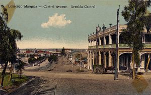
| العاصمة | ستون تاون (1507 to 1898) لورنسو ماركيز (1898 إلى 1975) | ||||||||
| اللغات الشائعة | البرتغالية | ||||||||
| رأس الدولة | |||||||||
• 1498–1521 | الملك مانوِل الأول من البرتغال | ||||||||
• 1974–75 | الرئيس فرانشسكو دا كوستا گوميش | ||||||||
| الحاكم العام | |||||||||
• 1609–11 | Sancho de Tovar (first) | ||||||||
• 1974–75 | Vítor Manuel Trigueiros Crespo (last) | ||||||||
| القبطان العام | |||||||||
• 1569–73 | Francisco Barreto (first) | ||||||||
• 1607–09 | Estêvão de Ataíde (last) | ||||||||
| الحقبة التاريخية | Imperialism | ||||||||
• تأسست | 1498 | ||||||||
• سقوط الامبراطورية البرتغالية | 25 يونيو 1975 | ||||||||
| Area | |||||||||
| 1967 | 784,955 km2 (303,073 sq mi) | ||||||||
| التعداد | |||||||||
• 1967 | 7,300,000 | ||||||||
| Currency | الريال الموزمبيقي (حتى 1914) سكودو موزمبيقي (1914–75) | ||||||||
| |||||||||
| Today part of | |||||||||
موزمبيق البرتغالية (برتغالية: Moçambique) أو شرق أفريقيا البرتغالي (África Oriental Portuguesa) هما التعبيران الشائعان للإشارة إلى موزمبيق في الفترة التاريخية حين كانت أراضي برتغالية وراء البحار. تكونت موزمبيق البرتغالية من سلسلة من المستعمرات البرتغالية ولاحقاً مقاطعة برتغالية وراء البحار على طول ساحل جنوب شرق أفريقيا، وتشكل الآن جمهورية موزمبيق.
المستوطنات التجارية، ولاحقاً، المستعمرات البرتغالية تشكلت على طول الساحل منذ 1498، حين وصل ڤاسكو دا گاما لأول مرة إلى ساحل موزمبيق. استكشف لورنسو ماركيز المنطقة التي هي خليج ماپوتو في 1544. وقد استوطن بشكل دائم في ما هو اليوم موزمبيق، حيث أمضى معظم عمره، وواصل عمله مستكشفون وبحارة وتجار برتغاليون آخرون. بعض تلك المستعمرات مُنـِحت في أواخر القرن 19 لتـُحكـَم chartered companies مثل شركة موزمبيق (Companhia de Moçambique)، التي كان لها امتياز الأراضي التي تقوم عليها المحافظات الحالية مانيكا و سفالة و شركة نياسا (Companhia do Niassa)، التي سيطرت على أراضي محافظات كابو دلگادو و نياسا. وفي 1951 جـُمِعت المستعمرات في مقاطعة واحدة وراء البحار تحت اسم Moçambique كجزء لا يتجزأ من البرتغال. معظم المستعمرات الأصلية أعطت أسمائها للمحافظات الحالية بموزمبيق.
Mozambique, according to official policy, was not a colony at all but rather a part of the "pluricontinental and multiracial nation" of Portugal. Portugal sought in Mozambique, as it did in all its colonies, to Europeanise the local population and assimilate them into Portuguese culture. Lisbon also wanted to retain the colonies as trading partners and markets for its goods. African inhabitants of the colony were ultimately supposed to become full citizens with full political rights through a long development process. To that end, segregation in Mozambique was minimal compared to that في جنوب أفريقيا المجاورة. However, paid forced labour, to which all Africans were liable if they failed to pay head tax, was not abolished until the early 1960s.
. . . . . . . . . . . . . . . . . . . . . . . . . . . . . . . . . . . . . . . . . . . . . . . . . . . . . . . . . . . . . . . . . . . . . . . . . . . . . . . . . . . . . . . . . . . . . . . . . . . . . . . . . . . . . . . . . . . . . . . . . . . . . . . . . . . . . . . . . . . . . . . . . . . . . . . . . . . . . . . . . . . . . . . .
التسميات
طوال تاريخها كمستعمرة برتغالية، فإن أراضي ما يسمى اليوم موزمبيق حملت التسميات الرسمية التالية:
- 1501–1569: قبطانية سـُفالة (برتغالية: Capitania de Sofala)
- 1570–1676: قبطانية موزمبيق وسفالة (Capitania de Moçambique e Sofala)
- 1676–1836: القبطانية العامة لموزمبيق وأنهار سفالة (Capitania-Geral de Moçambique e Rios de Sofala)
- 1836–1891: ولاية موزمبيق (Província de Moçambique)
- 1891–1893: ولاية شرق أفريقيا (Estado da África Oriental)
- 1893–1926: مقاطعة موزمبيق (Província de Moçambique)
- 1926–1951: مستعمرة موزمبيق (Colónia de Moçambique)
- 1951–1972: مقاطعة موزمبيق (Província de Moçambique)
- 1972–1975: ولاية موزمبيق (Estado de Moçambique)
التاريخ
حين وصل المستكشفون البرتغاليون شرق أفريقيا في 1498، Swahili commercial settlements had existed along the Swahili Coast and outlying islands for several centuries. From about 1500, Portuguese trading posts and forts became regular ports of call on the new route to the east.

رحلة ڤاسكو دا گاما حول رأس الرجاء الصالح إلى المحيط الهندي في 1498 marked the Portuguese entry into trade, politics, and society in the Indian Ocean world. The Portuguese gained control of the جزيرة موزمبيق وميناء سفالة في مطلع القرن 16. ولما كان ڤاسكو دا گاما قد زار ممباسة في 1498, was then successful in reaching India and this permitted the Portuguese to trade with the Far East directly by sea, thus challenging older trading networks of mixed land and sea routes, such as the spice trade routes that used the Persian Gulf, Red Sea and caravans to reach the eastern Mediterranean.
The Republic of Venice had gained control over much of the trade routes between Europe and Asia. After traditional land routes to India had been closed by the Ottoman Turks, Portugal hoped to use the sea route pioneered by da Gama to break the Venetian trading monopoly. Initially, Portuguese rule in East Africa focused mainly on a coastal strip centred in Mombasa. With voyages بقيادة ڤاسكو دا گاما، Francisco de Almeida and Afonso de Albuquerque, the Portuguese dominated much of southeast Africa's coast, including Sofala and Kilwa, by 1515.[2] Their main goal was to dominate trade with India. As the Portuguese settled along the coast, they made their way into the hinterland as sertanejos (backwoodsmen). These sertanejos lived alongside Swahili traders and even took up service among Shona kings as interpreters and political advisors. One such sertanejo managed to travel through almost all the Shona kingdoms, including the Mutapa Empire's (Mwenemutapa) metropolitan district, between 1512 and 1516.[3]
الجغرافيا
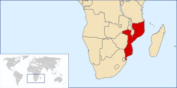
شرق أفريقيا البرتغالي كان يقع في جنوب شرق أفريقيا. It was a long coastal strip with Portuguese strongholds, from current day Tanzania and Kenya, to the south of موزمبيق الحالية.
In 1900, the part of modern Mozambique northwest of the Zambezi and Shire Rivers was called Moçambique; the rest of it was Lourenço Marques. Various districts existed, and even issued stamps, during the first part of the century, including Inhambane, Lourenço Marques, Mozambique Colony, شركة موزمبيق, شركة نياسا, Quelimane, Tete, and Zambésia. The Nyassa Company territory is now Cabo Delgado and Niassa.
In the early- and mid-20th century, a number of changes occurred. Firstly, on 28 June 1919, the Treaty of Versailles transferred the Kionga Triangle, a 1,000 km2 (390 sq mi) territory south of the Rovuma River from German East Africa to Mozambique.
During World War II, the Charter of the Mozambique Company expired, on 19 July 1942; its territory, known as Manica and Sofala, became a district of Mozambique. Mozambique was constituted as four districts on 1 January 1943 — Manica and Sofala, Niassa, Sul do Save (South of the Save River), and Zambézia.
On 20 October 1954, administrative reorganization caused Cabo Delgado and Mozambique districts to be split from Niassa. At the same time, the Sul do Save district was divided into Gaza, Inhambane and Lourenço Marques, while the Tete district was split from Manica and Sofala.
By the early 1970s, Mozambique was bordering the Mozambique Channel, bordering the countries of Malawi, Rhodesia, South Africa, Swaziland, Tanzania, and Zambia. Covering a total area of 801,590 km2 (309,500 square miles, slightly less than twice the size of California). With a tropical to subtropical climate, the Zambezi flows through the north-central and most fertile part of the country. Its coastline had 2,470 km (1,530 miles), with 4,571 km (2,840 miles) of land boundaries, its highest point at Monte Binga (2,436 metres, 7,992 ft). The Gorongosa National Park, founded in 1920, was the main natural park in the territory.
The districts with its respective capitals were:
- Lourenço Marques — Lourenço Marques;[4][5]
- Gaza — João Belo;[6]
- Inhambane — Inhambane;[7]
- Beira — Beira;[8][9]
- Vila Pery — Vila Pery;[10]
- Tete — Tete
- Zambézia — Quelimane;[11]
- Moçambique — Nampula
- Cabo Delgado — Porto Amélia;[12]
- Niassa — Vila Cabral
Other important urban centres included Sofala, Nacala,[13] António Enes, Island of Mozambique and Vila Junqueiro.[11]
الديمغرافيا
By 1970, the Portuguese Overseas Province of Mozambique had about 8,168,933 inhabitants. Nearly 300,000 were white ethnic Portuguese. There was a number of mulattoes, from both European and African ancestry, living across the territory. However, the majority of the population belonged to local tribal groups which included the Makua–Lomwe, the Shona and the Tsonga. Other ethnic minorities included British, Greeks, Chinese and Indians. Most inhabitants were black indigenous Africans with a diversity of ethnic and cultural backgrounds, ranging from Shangaan and Makonde to Yao or Shona peoples. The Makua were the largest ethnic group in the north. The Sena and Shona (mostly Ndau) were prominent in the Zambezi valley, and the Shangaan (Tsonga) dominated in the south. In addition, several other minority groups lived a tribal lifestyle across the territory.
Mozambique had around 250,000 Europeans in 1974 that made up around 3% of the population. Mozambique was cosmopolitan as it had Indian, Chinese, Greek and Anglophone communities (over 25,000 Indians and 5,000 Chinese by the early 1970s). The white population was more influenced from South Africa. The capital of Portuguese Mozambique, Lourenço Marques (Maputo), had a population of 355,000 in 1970 with around 100,000 Europeans. Beira had around 115,000 inhabitants at the time with around 30,000 Europeans. Most of the other cities ranged from 10 to 15% in the number of Europeans, while Portuguese Angola cities had European majorities ranging from 50% to 60%.
المجتمع
المراكز الحضرية
. . . . . . . . . . . . . . . . . . . . . . . . . . . . . . . . . . . . . . . . . . . . . . . . . . . . . . . . . . . . . . . . . . . . . . . . . . . . . . . . . . . . . . . . . . . . . . . . . . . . . . . . . . . . . . . . . . . . . . . . . . . . . . . . . . . . . . . . . . . . . . . . . . . . . . . . . . . . . . . . . . . . . . . .
التعليم
ثورة القرنفل والاستقلال
انظر أيضاً
- Estado Novo (Portugal)
- History of Mozambique
- List of colonial governors of Mozambique
- Arquivo Histórico Ultramarino (archives in Lisbon documenting Portuguese Empire, including Mozambique)
- Portuguese Angola
- Portuguese Guinea
الهامش
- ^ "Provinces of Mozambique". Statoids.com. Retrieved 17 May 2014.
- ^ Oliver, page 206
- ^ Oliver, page 207
- ^ Lourenço Marques "A cidade feitiço", a film of Lourenço Marques, Portuguese Mozambique in 1970.
- ^ Lourenço Marques, a film of Lourenço Marques, Portuguese Mozambique.
- ^ João Belo — Xai-Xai, a film of João Belo, Portuguese Mozambique, before 1975.
- ^ Inhambane - no outro lado do tempo, short film of Inhambane, Portuguese Mozambique before independence in 1975.
- ^ Cidade da Beira A short film of Beira, Portuguese Mozambique.
- ^ Beira — Centenário — O meu Tributo A film about Beira, Portuguese Mozambique, its Grande Hotel, and the railway station. Post-independence images of the city are shown, the film uses images of RTP 1's TV program Grande Reportagem.
- ^ Vila Pery — Chimoio, a film of Vila Pery, Portuguese Mozambique.
- ^ أ ب Quelimane, a film of the cosmopolitan port of Quelimane and tea centre of Vila Junqueiro, Portuguese Mozambique, before 1975.
- ^ Porto Amélia — Pemba, a film of Porto Amélia, Portuguese Mozambique.
- ^ Nacala — no outro lado do tempo, short film of Nacala, Portuguese Mozambique before independence in 1975.
Herrick, Allison and others (1969). "Area Handbook for Mozambique", US Government Printing Office.
ببليوگرافيا
 وسائط متعلقة بـPortuguese Mozambique من مشاع المعرفة.
- Gerardo A. Pery, ed. (1875). "Mocambique". Geographia e estatistica geral de Portugal e colonias (in البرتغالية). Lisbon: Imprensa Nacional.
{{cite book}}: Check|editor=value (help); External link in|chapterurl=|chapterurl=ignored (|chapter-url=suggested) (help)CS1 maint: multiple names: editors list (link) CS1 maint: numeric names: editors list (link) - "Portuguese East Africa" in the Catholic Encyclopedia (1913)
- Pages using gadget WikiMiniAtlas
- Articles containing برتغالية-language text
- Pages using infobox country with unknown parameters
- Pages using Lang-xx templates
- Articles with hatnote templates targeting a nonexistent page
- CS1 errors: unsupported parameter
- CS1 maint: numeric names: editors list
- CS1 البرتغالية-language sources (pt)
- Coordinates on Wikidata
- موزمبيق البرتغالية
- مستعمرات سابقة في أفريقيا
- Portuguese colonisation in Africa
- Colonial states of the Portuguese Empire
- مستعمرات برتغالية سابقة
- تاريخ موزمبيق
- شرق أفريقيا
- دول وأقاليم تأسست في 1498
- States and territories disestablished in 1975
- 15th-century establishments in Africa
- 1975 disestablishments in Africa


