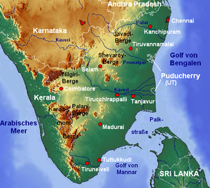
مضيق پالك


مضيق پالك (بالتاميل: பாக்கு சலசந்தி / பாக்கு நீரிணை؛ إنگليزية: Palk Strait) هو مضيق بين ولاية تاميل نادو الهندية و مقاطعة منر في المحافظة الشمالية في الأمة الجزيرة سري لانكا. ويربط خليج البنغال في الشمال الشرقي بخليج پالك ومنه إلى خليج منر في الجنوب الغربي.[1] ويبغ عرض المضيق 33 إلى 50 ميل (53 إلى 80 km).[2] ويصب فيه عدد من الأنهار، منها نهر ڤايگاي في تاميل نادو. المضيق مسمى على اسم روبرت پالك، الذي كان حاكم رئاسة مدراس (1755–1763) أثناء فترة راج الشركة.
الجغرافيا
It is studded at its southern end with a chain of low islands and reef shoals that are collectively called Adam's Bridge, since ages it is popularly known in Hindu Mythology as "Ram Setu" i.e. The Bridge of Rama.[3] This chain extends between Dhanushkodi on Pamban Island (also known as Rameswaram Island) in Tamil Nadu and Mannar Island in Sri Lanka. The island of Rameswaram is linked to the Indian mainland by the Pamban Bridge.
التاريخ
As from 1914, there used to be regular trains from Madras/Chennai to Dhanushkodi, a ferry to Talaimannar on Mannar Island, and hence a train to Colombo. In 1964, a cyclone destroyed Dhanushkodi and the railway and caused severe damage along the shores of Palk Strait and Palk Bay.[4] Dhanushkodi was not rebuilt and the railway from Talaimannar to Mahawilachchiya in Sri Lanka was given up. There was a ferry between small piers in Rameswaram and Talaimannar, but this was discontinued till date.[5]
القناة المقترحة
The shallow waters and reefs of the strait make it difficult for large ships to pass through, although fishing boats and small craft carrying coastal trade have navigated the strait for centuries. Large ships must travel around Sri Lanka. Construction of a shipping canal through the strait was first proposed to the British government of India in 1860, and a number of commissions have studied the proposal up to the present day. The most recent study of the Sethusamudram Shipping Canal Project, as it is now called, was an environmental impact assessment and a technical feasibility study commissioned by the Tamil Nadu government in 2004.[6]
However, the plan encountered opposition from various religious circles. The Indian epic poem Ramayana, written thousands of years ago in Sanskrit and an important Hindu text, recounts how Rama, with the help of an army of vanaras, built a bridge of stones across the sea to Lanka to rescue his wife Sita from the Asura king Ravana. The Ram Karmabhoomi movement, encouraged by a NASA satellite photograph of Rama's Setu, was formed to prevent the shipping canal from being built.[7]
Rahul Gandhi, a leader of the Congress party, sparked controversy by saying that Rama does not exist. This statement was later taken by Congress as 'Current Government said so'. Later the then Congress Government of India, in an affidavit in the Supreme Court of India, stated that there was no historical proof of the bridge being built by Rama.[بحاجة لمصدر]
انظر أيضاً
الهامش
- تحوي هذه المقالة معلومات مترجمة من الطبعة الحادية عشرة لدائرة المعارف البريطانية لسنة 1911 وهي الآن من ضمن الملكية العامة.
- ^ خريط سري لانكا ومضيق پالك وخليج پالك
- ^ المسافات مقاسة على گوگل إيرث
- ^ "Adam's bridge". Encyclopædia Britannica. 2007. Retrieved 2007-09-14.
- ^ Land's end
- ^ Sri Lanka, India to relaunch ferry service after three decades
- ^ Harnessing the Troubled Waters: Sethusamudram Canal Project
- ^ "Hanuman bridge is myth: Experts". Times of India. October 19, 2002. Retrieved 2011-04-25.
وصلات خارجية
- Pages using gadget WikiMiniAtlas
- Articles containing تاميلية-language text
- Articles containing إنگليزية-language text
- Pages using Lang-xx templates
- مقالات ذات عبارات بحاجة لمصادر
- مقالات مأخوذة من الطبعة الحادية عشرة لدائرة المعارف البريطانية
- Coordinates on Wikidata
- مضيق پالك
- مضائق الهند
- مضائق سري لانكا
- حدود سري لانكا-الهند
- مضائق دولية
- تضاريس تاميل نادو
