خليج كهمبات

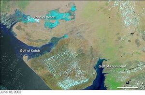
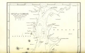
يُعد خليج كهمبات، المعروف تاريخيًا باسم خليج كامباي، خليجًا يقع على ساحل بحر العرب من الهند، على حدود دولة گجرات شمال ممباي.[1] يبلغ طول خليج كهمبات حوالي 200 km (120 mi)، وحوالي 20 km (12 mi) عرضًا في الشمال ويصل إلى مايقارب 70 km (43 mi)عرضًا في الجنوب. وهناك بعض الأنهار الرئيسية التي تستنزف گجرات هي نارمادا و تابي و ماهي و صابرماتي الذين يشكلون مصبات الأنهار في الخليج.[2] كما أنه يفصل شبه جزيرة كاثياوار عن الجزء الجنوبي الشرقي من ولاية گجرات.[3][4][5] وهناك خطط لبناء سد 30-كيلومتر (19 mi)، في مشروع كالباسار عبر الخليج [6]
الحياة البرية
إلى غرب الخليج، حيث يوجد هناك موطن الأسد الآسيوي منتزه غابة چير الوطني والمناطق المحيطة بها، منطقة كاثياوار أو سوراشترا.[3][7]أما إلى شرق الخليج، فهناك غابة دانگ ومحمية شولبانيشوار للحياة البرية، حيث تلتقي ولاية گجرات بولاية مهارشترا وولاية ماديا پرادش، الذي أُعتيداأن يتواجد فيهم نمر البنگال.[8]
انظر أيضاً
- مدينة كهمبات
- Coral reefs in India
- Dumas Beach
- Marine archaeology in the Gulf of Cambay
- Marine National Park, Gulf of Kutch
المراجع
- ^
 Chisholm, Hugh, ed. (1911). . دائرة المعارف البريطانية (eleventh ed.). Cambridge University Press.
 {{cite encyclopedia}}: Cite has empty unknown parameter:|coauthors=(help) - ^ Saha, S., Banerjee, S., Burley, S.D., Ghosh, A. and Saraswati, P.K. (2010). The influence of flood basaltic source terrains on the efficiency of tectonic setting discrimination diagrams: an example from the Gulf of Khambhat, western India. Sedimentary Geology 228 (1): 1–13.
- ^ أ ب Nowell, K.; Jackson, P. (1996). "Panthera Leo". Wild Cats: Status Survey and Conservation Action Plan (PDF). Gland, Switzerland: IUCN/SSC Cat Specialist Group. pp. 17–21. ISBN 2-8317-0045-0.
- ^ Trivedi, P. and Soni, V. C. (2012). Significant bird records and local extinctions in Purna and Ratanmahal Wildlife Sanctuaries, Gujarat, India Archived 2017-08-10 at the Wayback Machine
- ^ Jhala, Y. V., Qureshi, Q., Sinha, P. R. (Eds.) (2011). Status of tigers, co-predators and prey in India, 2010. National Tiger Conservation Authority, Government of India, New Delhi, and Wildlife Institute of India, Dehradun. TR 2011/003.
- ^ "The Gulf of Khambhat Development Project". Gujarat. Retrieved 18 May 2013.
- ^ "Asiatic Lion population up from 411 to 523 in five years". Desh Gujarat. 2015-05-10. Retrieved 2016-11-26.
- ^ Karanth, K. U. (2003). "Tiger ecology and conservation in the Indian subcontinent". Journal of the Bombay Natural History Society. 100 (2–3): 169–189. Archived from the original on 2012-03-10.
21°30′N 72°30′E / 21.500°N 72.500°E قالب:Hydrography of Gujarat

