بالاساگون
قرغيزية: Баласагын | |
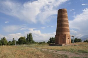
 برج بورانا، في موقع ما كانت بالاساگون | |
| الاسم البديل | گوباليق |
|---|---|
| المكان | Chüy Region، قيرغيزستان |
| المنطقة | صغديا |
| الإحداثيات | 42°44′49″N 75°14′55″E / 42.74694°N 75.24861°E |
| النوع | مستوطنة |
| التاريخ | |
| تأسس | القرن التاسع |
| ملاحظات حول الموقع | |
| الحالة | أطلال |
بالاساگون ( Balasagun ؛ قرغيزية: Баласагун or Баласагын Balasagyn; الصينية: 八剌沙袞) كانت مدينة صغدية قديمة في قيرغيزستان الحالية، وتقع في Chüy Valley between Bishkek and the Issyk-Kul lake. Located along the Silk Road, the ruins of the city were inscribed in 2014 on the UNESCO World Heritage List as part of the Silk Roads: the Routes Network of Chang'an-Tianshan Corridor World Heritage Site.[1]
Balasagun was founded by the Sogdians, a people of Iranian origin and the Sogdian language was still in use in this town until the 11th century.[2]
It was the capital of the Kara-Khanid Khanate from the 10th century until it was taken by the Qara Khitai (Western Liao dynasty) in 1134. It was then captured by the Mongols in 1218. The Mongols called it Gobalik "Pretty City". It should not be confused with Karabalghasun, now Ordu-Baliq في منغوليا، التي كانت عاصمة خانية الأويغور.
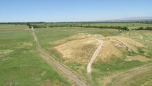
Founded by the Kara-Khanid Khanate in the ninth century, Balasagun soon supplanted Suyab as the main political and economical centre of the Chüy Valley; its prosperity declined after the Mongol conquest. The poet Yūsuf Balasaguni, known for writing the Kutadgu Bilig, is thought to have been born in Balasagun in the 11th century. The city also had a sizable Nestorian Christian population; one graveyard was still in use in the 14th century.[3] Since the 14th century, Balasagun is a village with plenty of ruins 12 كيلومتر (7.5 mi) southeast of Tokmok.
The Burana zone, located at the edge of Tokmok and 6 كيلومتر (3.7 mi) from the present village of Balasagun, was the west end of the ancient city. It includes the Burana Tower and a field of stone petroglyphs, the Kurgan stelae. The Burana Tower is a minaret built in the 11th century on the ruins of the ancient city Balasagun. It is 24 متر (79 ft) in height, though when it was first built it topped 46 متر (151 ft). Several earthquakes through the centuries caused much damage, and the current building represents a major renovation carried out in the 1970s.
المراجع
- ^ "Silk Roads: the Routes Network of Chang'an-Tianshan Corridor". UNESCO World Heritage Centre. United Nations Educational, Scientific, and Cultural Organization. Retrieved 17 Apr 2021.
- ^ Barthold, W. (2008). "Balāsāg̲h̲ūn or Balāsaḳūn". In Bearman, P.; Bianquis, Th.; Bosworth, C. E.; van Donzel, E.; Heinrichs, W. P. (eds.). Encyclopaedia of Islam. Brill. Retrieved 11 March 2008.
- ^ Klein, W. (2000). Das nestorianische Christentum an den Handelswegen durch Kyrgyzstan bis zum 14 Jh. Silk Road Studies (in الألمانية). Vol. III. Brepolis. ISBN 2-503-51035-3.
- Pages using gadget WikiMiniAtlas
- CS1 الألمانية-language sources (de)
- Short description is different from Wikidata
- Articles containing Kyrgyz-language text
- Coordinates on Wikidata
- Articles containing traditional Chinese-language text
- مواقع أثرية في قيرغيزستان
- مواقع مأهولة على طريق الحرير
- Chüy Region
- أماكن مأهولة سابقاً في قيرغيزستان
- مدن صغدية
- مدن مدمرة


