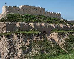
قلعة جنكي
36°40′01″N 66°59′03″E / 36.667°N 66.9841°E
قلعة جنگي (داري/پشتو: قلعهِ جنگی ؛ Qala-i-Jangi) هي حصن من القرن التاسع عشر يقع بالقرب من مزار شريف في شمال أفغانستان. وتشتهر بأنها كانت موقع انتفاضة دموية لطالبان في 2001، سُميت معركة قلعة جنگي، التي قـُتِل فيها ما لا يقل عن 470 شخصاً، بما فيهم ضابط وكالة المخابرات المركزية جوني "مايك" سپان. وكانت مقر الحامية العسكرية لـتحالف الشمال بقيادة الجنرال عبد الرشيد دوستم أثناء المراحل الافتتاحية في الحرب في أفغانستان (2001–2021).
التاريخ
الحصن بناه في 1889 عبد الرحمن خان، "الأمير الحديدي" في القرن التاسع عشر، وأول حاكم يوحد أفغانستان.[1] Then known as Dehdadi after the village nearby,[2] it was built with British funds and intended both to defend against Russian invasion and to suppress revolts by Uzbek tribes. Rahman described it as "the largest and strongest fort that had ever been built in Afghanistan." It took 18,000 workers 12 years to complete it.[3] In 1929, about 300 Russian troops were besieged inside the fort by 20,000 Turkmens.[4] The name Qala-i-Jangi was probably not given to the fort until the 1940s.[5] The Russians, with Dostum’s support, occupied it again after their 1979 invasion. هاجم المجاهدون قلعة جنگي في 1981، طاردين 170 جندي أفغاني مناصر للسوڤيت. ثم احتلت طالبان الحصن لمعظم الفترة من 1994 إلى 2001. عبد الرشيد دوستم، قائد تحالف الشمال، احتفظ بالحصن لفترة وجيزة في 1997، بميليشيا تبلغ 20,000 مقاتل.[3]
الوصف
In 2001, the fort was 600 ياردة (550 m) long, 300 ياردة (270 m) wide. It was constructed out of wooden beams, mud and straw. At each corner a mud tower rose 80 أقدام (24 m) high and 150 أقدام (46 m) across. Rainfall of 4 بوصات (100 mm) annually enabled the structure to avoid liquification.[3] It was a walled city, divided evenly into northern and southern courtyards by an 80 أقدام (24 m) wall.[3] It contained a gold-domed mosque, a 75 أقدام (23 m) square "Pink House," erected in the 1980s by the occupying Soviet Union, as a medical facility.[3] On November 26, 2001, the north-eastern tower was destroyed by an errant American JDAM missile.[6]
انظر أيضاً
المراجع
- ^ Harnden, Toby, "First Casualty: The Untold Story of the CIA Mission to Avenge 9/11. Little, Brown, 2021. p. 133
- ^ Harnden, "First Casualty," p. 133
- ^ أ ب ت ث ج Stanton, Doug (2018). 12 Strong (previously published as "Horse Soldiers". New York City: Pocket Books. ISBN 978-1-5011-7995-2.
- ^ Harnden, "First Casualty," p. 134
- ^ Harnden, "First Casualty," p. 134
- ^ Harnden, "First Casualty," p. 247


