كاريا
| كاريا (Καρία) | |
|---|---|
| منطقة قديمة في الأناضول | |
 مسرح في كاونوس | |
| الموقع | جنوب غرب الأناضول |
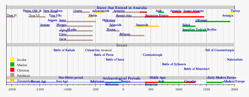
| الدولة تواجدت | القرون 11–6 ق.م. |
| اللغة | الكارية |
| أكبر مدينة | هاليكرناسوس |
| المقاطعة الرومانية | آسيا |
كاريا (Caria ؛ /ˈkɛəriə/؛ من اليونانية: Καρία، كاريا، تركية: Karya) كانت منطقة في غرب الأناضول امتدت على الساحل من وسط أيونيا (موكالى) جنوباً إلى لوكيا وشرقاً إلى فريگيا.[1] استعمر اليونانيون الأيونيون والدوريون غربها والتحقوا بالسكان الكاريين في خلق دول يسيطر عليها اليونانيون هنا. وكان سكان كاريا، المعروفون بالكاريين، قد وصلوا هناك قبل اليونانيين الأيونيين والدوريين. وقد وصفهم هيرودوت بأنهم من أصل يوناني مينوي،[2] بينما أصر الكاريون أنفسهم بانحدارهم من بر الأناضول وخوضهم عباب البحر بكثرة وقرابتهم مع الموسيين والليديين.[2] وكان الكاريون يتكلمون لغة أناضولية، تُعرف بالكارية، والتي لا تعكس بالضرورة أصلهم الجغرافي، إذ أن الأناضوليين كانوا قد تفرقوا في وقتٍ ما.[بحاجة لمصدر] كما يرتبط بوثوق مع الكاريين شعب للگس، الذي ربما كان اسماً مبكراً للكاريين أو لشعب سبقهم في نفس المنطقة وواصل التواجد كجزء من مجتمعهم كطائفة من الدرجة الثانية، كما يشاع.[بحاجة لمصدر]
بلديات كاريا

التاريخ
الدول والشعوب اليونانية قبل الكلاسيكية
The name of Caria also appears in a number of early languages: Hittite Karkija (a member state of the Assuwa league, c. 1250 BC), Babylonian Karsa, Elamite and Old Persian Kurka. According to Herodotos, the legendary King Kar, son of Zeus and Creta, founded Caria and named it after him, and his brothers Lydos and Mysos founded Lydia and Mysia, respectively.
دولة ذات سيادة تستضيف اليونانيين

Caria arose as a Neo-Hittite kingdom around the 11th century BC.[بحاجة لمصدر] The coast of Caria was part of the Doric hexapolis ("six-cities") when the Dorians arrived after the Trojan War, in c. 13th century BC, in the last and southernmost waves of Greek migration to western Anatolia's coastline and occupied former Mycenaean settlements such us Knidos and Halicarnassos (near present-day Bodrum). Herodotus, the famous historian was born in Halicarnassus during the 5th century BC. Greek apoikism (a form of colonization) in Caria took place mostly on the coast, as well as in the interior in great number, and groups of cities and towns were organized in local federations.
Homer's Iliad records that at the time of the Trojan War, the city of Miletus belonged to the Carians, and was allied to the Trojan cause.
مقاطعة ليدية
The expansionism of Lydia under Croesus (560-546 BC) incorporated Caria briefly into Lydia before it fell before the Achaemenid advance.
ساتراپي فارسية


الامبراطورية المقدونية
مقاطعة رومانية-بيزنطية
الفض تحت الامبراطورية البيزنطية وانتقالها للحكم التركي
In the 7th century, Byzantine provinces were abolished and the new military theme system was introduced. The region corresponding to ancient Caria was captured by the Turks under the Menteşe Dynasty in the early 13th century.
There are only indirect clues regarding the population structure under the Menteşe and the parts played in it by Turkish migration from inland regions and by local conversions, but the first Ottoman Empire census records indicate, in a situation not atypical for the region as a whole, a large Muslim (practically exclusively Turkish) majority reaching as high as 99% and a non-Muslim minority (practically exclusively Greek supplemented with a small Jewish community in Milas) as low as one per cent.[4] One of the first acts of the Ottomans after their takeover was to transfer the administrative center of the region from its millenary seat in Milas to the then much smaller Muğla, which was nevertheless better suited for controlling the southern fringes of the province. Still named Menteşe until the early decades of the 20th century, the kazas corresponding to ancient Caria are recorded by sources such as G. Sotiriadis (1918) and S. Anagiostopoulou (1997) as having a Greek population averaging at around ten per cent of the total, ranging somewhere between twelve and eighteen thousand, many of them reportedly recent immigrants from the islands. Most chose to leave in 1919, before the population exchange.
انظر أيضاً
الهامش
- ^
 Chisholm, Hugh, ed. (1911). . دائرة المعارف البريطانية (eleventh ed.). Cambridge University Press.
 {{cite encyclopedia}}: Cite has empty unknown parameter:|coauthors=(help) - ^ أ ب The Histories, Book I Section 171.
- ^ On the identification with Artemisia: "...Above the ships of the victorious Greeks, against which Artemisia, the Xerxes' ally, sends fleeing arrows...". Original German description of the painting: "Die neue Erfindung, welche Kaulbach für den neuen hohen Beschützer zu zeichnen gedachte, war wahrscheinlich „die Schlacht von Salamis“. Ueber den Schiffen der siegreichen Griechen, gegen welche Artemisia, des Xerxes Bundesgenossin, fliehend Pfeile sendet, sieht man in Wolken die beiden Ajaxe" in Altpreussische Monatsschrift Nene Folge p.300
- ^ Muhammet Yazıcı (2002). "XVI. Yüzyılda Batı Anadolu Bölgesinde (Muğla, İzmir, Aydın, Denizli) Türkmen Yerleşimi ve Demografik Dağılım (Turkmen Settlement and the Demographic Distribution of Western Anatolia in the 16th century), pp. 124-142 for Menteşe Subprovince" (PDF). Muğla University. Archived from the original (PDF) on 4 March 2011.
{{cite web}}: Unknown parameter|deadurl=ignored (|url-status=suggested) (help)
ببليوگرافيا
- Bean, George E. (1971). Turkey beyond the Maeander. London: Frederick A. Praeger. ISBN 0-87471-038-3.
- Cramer, J.A. (1832). Geographical and Historical Description of Asia Minor; with a Map: Volume II. Oxford: University Press. Section X Caria.
{{cite book}}: Unknown parameter|nopp=ignored (|no-pp=suggested) (help) Downloadable Google Books.  Herodotus: History of Herodotus on Wikisource
للاستزادة
- Riet van Bremen, Jan-Mathieu Carbon (ed.), Hellenistic Karia: Proceedings of the First International Conference on Hellenistic Karia, Oxford, 29 June-2 July 2006 (Talence: Ausonius Editions, 2010). (Etudes, 28).
- Lars Karlsson and Susanne Carlsson, Labraunda and Karia (Uppsala, 2011).
وصلات خارجية
- مقالات المعرفة المحتوية على معلومات من دائرة المعارف البريطانية طبعة 1911
- CS1 errors: unsupported parameter
- Pages using gadget WikiMiniAtlas
- صفحات تستخدم خطا زمنيا
- Pages using Lang-xx templates
- Articles with unsourced statements from January 2017
- مقالات ذات عبارات بحاجة لمصادر
- Articles with hatnote templates targeting a nonexistent page
- Coordinates on Wikidata
- كاريا
- دول وأقاليم انحلت في القرن السادس ق.م.
- جغرافيا يونانية قديمة
- مواقع أثرية يونانية قديمة في تركيا
- كاريون
- مناطق تاريخية في الأناضول
- تاريخ محافظة آيدين
- تاريخ محافظة موغلا
- مستعمرات أيونية
- Praetorian prefecture of the East
- دول وأقاليم تأسست في القرن 11 ق.م.
- آسيا الرومانية


