موغلا
(تم التحويل من Muğla)
موغلا | |
|---|---|
عاصمة محافظة وقضاء | |
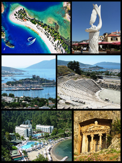
 أعلى اليسار: Ölüdeniz، أعلى اليمين: نحت في مرمريس, يسار الوسط: قلعة القديس بطرس في بودروم، يمين الوسط: مسرح هاليكارناسوس، أسفل اليسار: Otel Turunç, أسفل يمين: مقبرة أمينتاس. | |
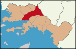
 موقع قضاء موغلا في محافظة موغلا. | |
| الإحداثيات: 37°13′N 28°22′E / 37.217°N 28.367°E | |
| البلد | |
| المنطقة | إيجة |
| المحافظة | موغلا |
| ذُكِرت لأول مرة | في القرن الثاني ق.م. بالإسم المحلي Mobolla أثناء مرورها من Carian federation linked with Taba (Tavas) to Rhodian domination. |
| Lycian or Carian to Menteşe Turkish period (14th century) | Cited as Mobolla with an intermediate form Mogolla attested later. |
| فترة منتشه التركية (القرن 13) وحتى الآن | مذكورة بإسم موغلا ومركز حضري في منتشه، بعد 1426 أصبحت مركز ولاية عثمانية، وبعد 1923 أصبحت مركز محافظة بنفس الاسم في جمهورية تركيا |
| البلديات | 5 |
| الحكومة | |
| • العمدة | Osman Gürün (CHP) |
| المساحة | |
| • القضاء | 1٬660٫55 كم² (641٫14 ميل²) |
| المنسوب | 660 m (2٬170 ft) |
| التعداد (2012)[2] | |
| • Urban | 64٬706 |
| • District | 99٬158 |
| • كثافة District | 60/km2 (150/sq mi) |
| منطقة التوقيت | UTC+3 (EET) |
| • الصيف (التوقيت الصيفي) | UTC+3 (EEST) |
| مفتاح الهاتف | (+90) 252 |
| Licence plate | 48 |
| الموقع الإلكتروني | Muğla Municipality Governorship of Muğla |
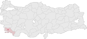
مدينة موغلا (تركية: Muğla) هي عاصمة محافظة موغلا تقع في جنوب غرب تركيا وتطل على ساحل بحر إيجة. ويبلغ تعداد سكانها حوالي 43,845 نسمة.
المناخ
تتمتع موغلا بمناخ البحر المتوسط. It is characterised by long, hot and dry summers with cool and wet winters.
| Climate data for موغلا | |||||||||||||
|---|---|---|---|---|---|---|---|---|---|---|---|---|---|
| Month | Jan | Feb | Mar | Apr | May | Jun | Jul | Aug | Sep | Oct | Nov | Dec | Year |
| Mean daily maximum °C (°F) | 10.1 (50.2) |
10.9 (51.6) |
14.3 (57.7) |
18.6 (65.5) |
24.4 (75.9) |
29.8 (85.6) |
33.5 (92.3) |
33.5 (92.3) |
29.3 (84.7) |
23.3 (73.9) |
16.5 (61.7) |
11.4 (52.5) |
21.3 (70.3) |
| Mean daily minimum °C (°F) | 1.5 (34.7) |
1.8 (35.2) |
3.6 (38.5) |
7.0 (44.6) |
11.3 (52.3) |
16.2 (61.2) |
19.7 (67.5) |
19.6 (67.3) |
15.2 (59.4) |
10.2 (50.4) |
5.6 (42.1) |
3.2 (37.8) |
9.6 (49.2) |
| Average precipitation mm (inches) | 222.7 (8.77) |
183.0 (7.20) |
118.3 (4.66) |
71.0 (2.80) |
46.8 (1.84) |
22.7 (0.89) |
9.8 (0.39) |
10.2 (0.40) |
23.3 (0.92) |
69.2 (2.72) |
139.2 (5.48) |
272.9 (10.74) |
1٬189٫1 (46.81) |
| Average rainy days | 14.1 | 13.2 | 10.9 | 9.9 | 7.8 | 3.6 | 1.6 | 1.4 | 2.8 | 6.6 | 9.8 | 14.9 | 96.6 |
| Average relative humidity (%) | 76 | 76 | 72 | 67 | 61 | 52 | 45 | 47 | 50 | 62 | 73 | 80 | 63 |
| Mean monthly sunshine hours | 127.1 | 140.0 | 189.1 | 213.0 | 263.5 | 306.0 | 341.0 | 331.7 | 288.0 | 229.4 | 153.0 | 114.7 | 2٬696٫5 |
| Source 1: Devlet Meteoroloji İşleri Genel Müdürlüğü [3] | |||||||||||||
| Source 2: Weatherbase [4] | |||||||||||||
انظر أيضاً
الهامش
- ^ "Area of regions (including lakes), km²". Regional Statistics Database. Turkish Statistical Institute. 2002. Retrieved 2013-03-05.
- ^ "Population of province/district centers and towns/villages by districts - 2012". Address Based Population Registration System (ABPRS) Database. Turkish Statistical Institute. Retrieved 2013-02-27.
- ^ İl ve İlçelerimize Ait İstatistiki Veriler- Meteoroloji Genel Müdürlüğü
- ^ http://www.weatherbase.com/weather/weatherall.php3?s=29271&refer=&units=us&cityname=Mugla-Turkey
وصلات خارجية
الكلمات الدالة:


