هرارى
Harare | |
|---|---|
Capital city and Province | |
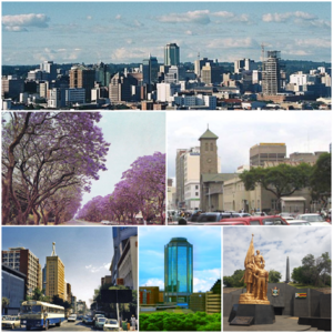
 Clockwise, from top: Harare skyline; Jacaranda trees lining Josiah Chinamano Avenue; Parliament of Zimbabwe (front) and the Anglican Cathedral (behind); downtown Harare; New Reserve Bank Tower; Heroes Acre monument | |
| الكنية: Sunshine City, H Town | |
الشعار:
| |
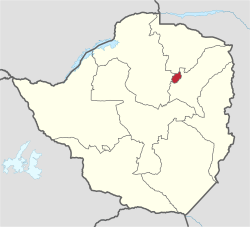
 Location of Harare Province in Zimbabwe | |
| الإحداثيات: 17°49′45″S 31°3′8″E / 17.82917°S 31.05222°E | |
| البلد | زيمبابوى |
| المحافظة | هراره |
| Incorporated (city) | 1935 |
| Renamed Harare | 18 April 1982 |
| الحكومة | |
| • النوع | Mayor-council government |
| • العمدة | Jacob Mafume (MDC) |
| المساحة | |
| • Capital city and Province | 960٫6 كم² (370٫9 ميل²) |
| المنسوب | 1٬490 m (4٬890 ft) |
| التعداد (2012 Census) | |
| • Capital city and Province | 2٬123٬132[1] |
| • Estimate (2019) | 3٬120٬917[3] |
| • Urban | 2٬013٬048[2] |
| صفة المواطن | Hararean |
| منطقة التوقيت | UTC+2 (CAT) |
| مفتاح الهاتف | 242 |
| HDI (2018) | 0.645[4] Medium |
| Dialling code 242 (or 0242 from within Zimbabwe) | |
هرارى Harare (كانت تسمى سالزبرى Salisbury سابقاً) عاصمة زيمبابوه يقدر سكانها 2,123,132 in the 2012 census[1] and an estimated 3,120,917 in its metropolitan area in 2019.[3] Situated in north-eastern Zimbabwe in the country's Mashonaland region, Harare is a metropolitan province, which also incorporates the municipalities of Chitungwiza and Epworth.[5] The city sits on a plateau at an elevation of 1,483 metres (4,865 feet) above sea level and its climate falls into the subtropical highland category.
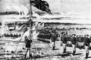
The city was founded in 1890 by the Pioneer Column, a small military force of the British South Africa Company, and named Fort Salisbury after the UK Prime Minister Lord Salisbury. Company administrators demarcated the city and ran it until Southern Rhodesia achieved responsible government in 1923. Salisbury was thereafter the seat of the Southern Rhodesian (later Rhodesian) government and, between 1953 and 1963, the capital of the Central African Federation. It retained the name Salisbury until 1982, when it was renamed Harare on the second anniversary of Zimbabwean independence from the United Kingdom.
Long the commercial capital of Zimbabwe, Harare has seen economic ups and downs since the 2000s. It remains an important centre of commerce, government, finance, real estate, manufacturing, healthcare, design, education, art, culture, tourism, agriculture, mining and regional affairs.[6] Harare has the second-highest number of embassies in Southern Africa and serves as the location of the African headquarters of the World Health Organization, which it shares with Brazzaville.[7]
Harare has hosted multiple international conferences and events, including the 1995 All-Africa Games and the 2003 Cricket World Cup. In 2018, Harare was ranked as a Gamma world city. The city's marquee festival is the Harare International Festival of the Arts, modelled on the Edinburgh Festival and one of the largest arts festivals in the southern hemisphere.[8] It is also home to Dynamos F.C., the club with the most titles in Zimbabwean football.
وتعد أكبر مدن زيمبابوي و مركزها المالي و الإداري والإتصالي و مركز لتجارة التبغ و الذرة و القطن و الحمضيات وتتضمن صناعة المنسوجات و الصلب و الكيماويات كما يوجد تنقيب عن الذهب بالمنطقة و تقع على إرتفاع 1483 متر و يتميز مناخها بالدفء.
التاريخ
المناخ
| Climate data for هرارى (1961–1990, extremes 1897–present) | |||||||||||||
|---|---|---|---|---|---|---|---|---|---|---|---|---|---|
| Month | Jan | Feb | Mar | Apr | May | Jun | Jul | Aug | Sep | Oct | Nov | Dec | Year |
| Record high °C (°F) | 33.9 (93.0) |
35.0 (95.0) |
32.3 (90.1) |
32.0 (89.6) |
30.0 (86.0) |
27.7 (81.9) |
28.8 (83.8) |
31.0 (87.8) |
35.0 (95.0) |
36.7 (98.1) |
35.3 (95.5) |
33.5 (92.3) |
36.7 (98.1) |
| Mean daily maximum °C (°F) | 26.2 (79.2) |
26.0 (78.8) |
26.2 (79.2) |
25.6 (78.1) |
23.8 (74.8) |
21.8 (71.2) |
21.6 (70.9) |
24.1 (75.4) |
28.4 (83.1) |
28.8 (83.8) |
27.6 (81.7) |
26.3 (79.3) |
25.5 (77.9) |
| Daily mean °C (°F) | 21.0 (69.8) |
20.7 (69.3) |
20.3 (68.5) |
18.8 (65.8) |
16.1 (61.0) |
13.7 (56.7) |
13.4 (56.1) |
15.5 (59.9) |
18.6 (65.5) |
20.8 (69.4) |
21.2 (70.2) |
20.9 (69.6) |
18.4 (65.1) |
| Mean daily minimum °C (°F) | 15.8 (60.4) |
15.7 (60.3) |
14.5 (58.1) |
12.5 (54.5) |
9.3 (48.7) |
6.8 (44.2) |
6.5 (43.7) |
8.5 (47.3) |
11.7 (53.1) |
14.5 (58.1) |
15.5 (59.9) |
15.8 (60.4) |
12.3 (54.1) |
| Record low °C (°F) | 9.6 (49.3) |
8.0 (46.4) |
7.5 (45.5) |
4.7 (40.5) |
2.8 (37.0) |
0.1 (32.2) |
0.1 (32.2) |
1.1 (34.0) |
4.1 (39.4) |
5.1 (41.2) |
6.1 (43.0) |
10.0 (50.0) |
0.1 (32.2) |
| Average precipitation mm (inches) | 190.8 (7.51) |
176.3 (6.94) |
99.1 (3.90) |
37.2 (1.46) |
7.4 (0.29) |
1.8 (0.07) |
2.3 (0.09) |
2.9 (0.11) |
6.5 (0.26) |
40.4 (1.59) |
93.2 (3.67) |
182.7 (7.19) |
840.6 (33.09) |
| Average precipitation days | 17 | 14 | 10 | 5 | 2 | 1 | 0 | 1 | 1 | 5 | 10 | 16 | 82 |
| Average relative humidity (%) | 76 | 77 | 72 | 67 | 62 | 60 | 55 | 50 | 45 | 48 | 63 | 73 | 62 |
| Mean monthly sunshine hours | 217.0 | 190.4 | 232.5 | 249.0 | 269.7 | 264.0 | 279.0 | 300.7 | 294.0 | 285.2 | 231.0 | 198.4 | 3٬010٫9 |
| Mean daily sunshine hours | 7.0 | 6.8 | 7.5 | 8.3 | 8.7 | 8.8 | 9.0 | 9.7 | 9.8 | 9.2 | 7.7 | 6.4 | 8.2 |
| Source 1: World Meteorological Organization,[9] NOAA (sun and mean temperature, 1961–1990),[10] | |||||||||||||
| Source 2: Deutscher Wetterdienst (humidity, 1954–1975),[11] Meteo Climat (record highs and lows)[12] | |||||||||||||
المدن الشقيقة
Harare has co-operation agreements and partnerships with the following towns:[13]
 Cincinnati, United States[14]
 Guangzhou, China[15]
 Kazan, Russia
 Lago, Italy
 Maputo, Mozambique[16]
 Munich, Germany
 Nakhon Ratchasima, Thailand
 Nottingham, United Kingdom
 Prato, Italy
 Windhoek, Namibia
معرض صور
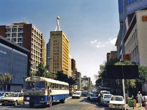
Sam Nujoma Street, المنظر جنوباً
وصلات خارجية
- ^ أ ب Zimstat. "2012 Population Census National Report" (PDF). Retrieved September 20, 2020.
- ^ Zimstat. "2012 Population Report: Harare" (PDF). Retrieved September 20, 2020.
- ^ أ ب Zimstat. "2019 Labour Force Report" (PDF). Retrieved September 20, 2020.
- ^ "Sub-national HDI – Area Database – Global Data Lab". hdi.globaldatalab.org (in الإنجليزية). Retrieved 2020-09-20.
- ^ Harare Provincial Profile. Parliament Research Department. 2011. Archived from the original. You must specify the date the archive was made using the
|archivedate=parameter. http://www.parlzim.gov.zw/attachments/article/128/Harare%20Provincial%20Profile.pdf. Retrieved on 22 November 2013. - ^ Abu Hassan Abu Bakar, Arman Abd Razak, Shardy Abdullah and Aidah Awang. "PROJECT MANAGEMENT SUCCESS FACTORS FOR SUSTAINABLE HOUSING: A FRAMEWORK" (PDF). School of Housing, Building and Planning, Universiti Sains Malaysia, Pulau Pinang, Malaysia. Retrieved 2022-03-03 – via eprints.usm.my.
{{cite web}}: CS1 maint: multiple names: authors list (link) - ^ "Who we are". www.who.int (in الإنجليزية). Retrieved 2021-06-21.
- ^ "Harare International Festival of the Arts (HIFA)". www.kadmusarts.com. Retrieved 2021-06-21.
- ^ "World Weather Information Service – Harare". World Meteorological Organization. Retrieved 10 June 2016.
- ^ "Harare Kutsaga Climate Normals 1961–1990". National Oceanic and Atmospheric Administration. Retrieved 10 June 2016.
- ^ "Klimatafel von Harare-Kutsaga (Salisbury) / Simbabwe" (PDF). Baseline climate means (1961–1990) from stations all over the world (in الألمانية). Deutscher Wetterdienst. Retrieved 10 June 2016.
- ^ "Station Harare" (in الفرنسية). Meteo Climat. Retrieved 10 June 2016.
- ^ Dhedheya, Itai. "City of Harare – Twinning Arrangements". City of Harare. Archived from the original on 15 April 2019. Retrieved 10 June 2017.
- ^ Pennick, Faith; Calhoun, Jim (1990-08-05). "Harare newest link: Cincinnati adds sister city in Africa". The Cincinnati Enquirer. Retrieved 2018-05-21.
- ^ "Harare twins Guangzhou". The Herald (in الإنجليزية البريطانية). 2015-09-22. Retrieved 2018-05-23.
- ^ Kalayil, Sheena (2015-04-02). The Beloved Country (in الإنجليزية). Grosvenor House Publishing. p. 29. ISBN 9781781484647.
- Pages using gadget WikiMiniAtlas
- Short description is different from Wikidata
- Articles containing شونا-language text
- Pages using infobox settlement with possible motto list
- Coordinates on Wikidata
- Articles with hatnote templates targeting a nonexistent page
- مدن مضيفة لدورة الألعاب الأفريقية
- عواصم أفريقيا
- مقاطعات زيمبابوي
- مدن وبلدات وقرى في زيمبابوي
- تأسيسات 1890
- هراري
- CS1 الألمانية-language sources (de)
- CS1 الفرنسية-language sources (fr)
- CS1 الإنجليزية البريطانية-language sources (en-gb)


