زمبابوى
| جمهورية زمبابوى زمبابوى | |
|---|---|
Motto: "Unity, Freedom, Work" | |
النشيد: [Simudzai Mureza wedu WeZimbabwe] Error: {{Lang}}: text has italic markup (help) (شونا) [Kalibusiswe Ilizwe leZimbabwe] Error: {{Lang}}: text has italic markup (help) (sindebele) "مباركة أرض زمبابوى" | |
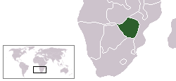 | |
| العاصمة | هراري (سالزبري سابقا) |
| أكبر مدينة | هراري |
| اللغات الرسمية | 16 languages:[1] |
| جماعات عرقية (2012) |
|
| صفة المواطن | زمبابوى |
| الحكم | جمهورية Unitary presidential |
• الرئيس | إمرسون منانگاگوا |
| Constantino Chiwenga Kembo Mohadi | |
| Edna Madzongwe | |
| جون نكومى | |
| الاستقلال عن المملكة المتحدة | |
• روديسيا | 11 نوفمبر, 1965 |
• زمبابوى | 18 ابريل, 1980 |
| المساحة | |
• إجمالي | 390،757 km2 (150،872 sq mi) (60th) |
• Water (%) | 1 |
| التعداد | |
• تقدير يوليو 2005 | 13,010,0001 (68th) |
• Density | 33/km2 (85.5/sq mi) (170th) |
| ن.م.إ. (PPP) | تقدير 2005 |
• الإجمالي | $30.581 بليون (94th) |
• للفرد | $2,607 (129th) |
| Gini (2003) | 56.8 high |
| HDI (2007) | ▲ 0.513 Error: Invalid HDI value · 151st |
| العملة | Dollar ($) (ZWD) |
| منطقة التوقيت | توقيت أفريقيا الوسطى (UTC+2) |
• الصيفي (DST) | لم تراع (UTC+2) |
| Calling code | 263 |
| Internet TLD | .zw |
1 Estimates explicitly take into account the effects of excess mortality due to AIDS. | |
زمبابوي دولة إفريقية وهي المستعمرة البريطانية السابقة روديسيا الجنوبية ، والتي أعلن أيان سميث زعيم الأقلية البيضاء انفصالها واستقلالها عن بريطانيا في سنة (1385 هـ - 1965 م ) ، وقد أثارث سياسة سميث العنصرية غضب المجتمع الدولي ، فأعلنت دول عديدة مقاطعة روديسيا اقتصادياً، وفرضت هيئة الأمم المتحدة مقاطعة اقتصادية على حكومة سميت ونتج عن السياسة العنصرية التي اتبعتها الأقلية البيضاء تأييد عالمي لجبهة تحرير زمبابوي ، بزعامة موگابه وجوشوا نكومو وأخيرا نالت روديسيا استقلالها تحت حكم الأغلبية الأفريقية، وعرفت بجمهورية زمبابوي.
التاريخ
الاستعمار
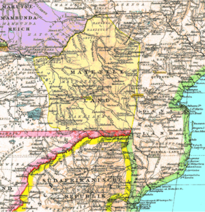
الحرب الاهليه
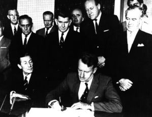
الاستقلال سنة 1980
الجغرافيا
 مقالة مفصلة: جغرافيا زمبابوى
الموقع
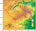
توجد زمبابوي في القسم الجنوبي الشرقي من وسط القارة الأفريقية ، وهي دولة داخلية لاسواحل لها ، إذ تبعد عن المحيط الهندي حوالي مائتين من الكيلومترات ، ومخرجها من موزمبيق التي تحدها من الشرق والشمال الشرقي ، وزامبيا من الشمال الغربي وبتسوانا من الغرب ، وجمهورية اتحاد جنوبي أفريقيا من الجنوب ، وتبلغ مساحة البلاد 390,759 . ويبلغ سكان زمبابوي سنة (1408 هـ -1988 م) 9,116,000 نسمة ، وعاصمة البلاد هراري وسكان العاصمة 700ألف ، ومن المدن الهامة بلاوايو وجوباو ويقدر عدد المسلمين بحوالي 800 ألف نسمة .
التقسيمات الادارية
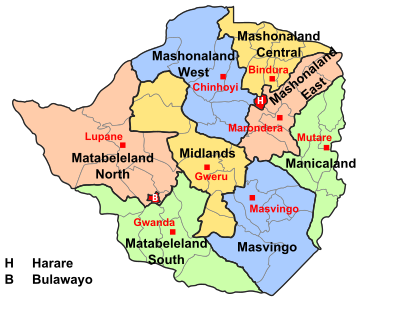
Zimbabwe has a centralised government and is divided into eight provinces and two cities with provincial status, for administrative purposes. Each province has a provincial capital from where government administration is usually carried out.[2]
| المحافظة | العاصمة |
|---|---|
| بولاوايو | بولاوايو |
| هرارى | هرارى |
| Manicaland | موتارى |
| Mashonaland Central | Bindura |
| Mashonaland East | Marondera |
| Mashonaland West | Chinhoyi |
| Masvingo | Masvingo city |
| Matabeleland North | Lupane District |
| Matabeleland South | گواندا |
| Midlands | گوِرو |
The names of most of the provinces were generated from the Mashonaland and Matabeleland divide at the time of colonisation: Mashonaland was the territory occupied first by the British South Africa Company Pioneer Column and Matabeleland the territory conquered during the First Matabele War. This corresponds roughly to the precolonial territory of the Shona people and the Matabele people, although there are significant ethnic minorities in most provinces. Each province is headed by a Provincial Governor, appointed by the President.[3]
The provincial government is run by a Provincial Administrator, appointed by the Public Service Commission. Other government functions at provincial level are carried out by provincial offices of national government departments.[4]
المحافظات تنقسم إلى 59 مقاطعة and 1,200 wards (sometimes referred to as municipalities). Each district is headed by a District Administrator, appointed by the Public Service Commission. There is also a Rural District Council, which appoints a chief executive officer. The Rural District Council is composed of elected ward councillors, the District Administrator and one representative of the chiefs (traditional leaders appointed under customary law) in the district. Other government functions at district level are carried out by district offices of national government departments.[5]
الأرض
أرضها عبارة عن هضبة متوسطة ، ارتفاعها حوالي ألف متر ، وهي قسم من صحراء ناميبيا (صحراء كالاهاري). وأبرز المجاري المائية بها نهر أوكاڤانگو الذي يصب في مستنقع أوكاڤانگو في شمالها الغربي.
ومناخ بتسوانا حار في الصيف (الجنوبي ) وبارد في الشتاء وتتساقط أمطارها القليلة في فصل الصيف وتغطي الحشائش والشجيرات معظم أرضها ، وهذا أتاح فرصة لحياة رعوية حيث ٍ تربي قطعان الأبقار ، والماعز والأغنام .
الحكومه والسياسه
 مقالة مفصلة: سياسة زمبابوي
السكان
النشاط البشري
بنصب على حرفتي الزراعة والرعي ويعمل بالزراعة 69% من القوة العاملة. وأبرز الحاصلات الزراعية الذرة والقمح والأرز ، ومن الحاصلات النقدية القطن وقصب السكر. ولقد قام الأوروبيين بزراعة غلات تجارية جديدة، وتربي قطعان الماشية على حشائش السافانا ، ولزمبابوي شهرة في إنتاج النحاس وبلغ إنتاجها في سنة (1400 هـ، -1980 م ) من النحاس (27 ألف طن ) ومن خام النيكل ( 15 ألف طن ) والذهب (367 كيلو غراماً ) والكروم (553ألف طن ) ، وكانت تسيطر الأقلية البيضاء على أخصب الأراضي والمناجم وتربي ثروة حيوانية لابأس بها زمبابوي وقدرت ثروتها في سنة ( 1408 هـ - 1988 م ) بحوالي 5,700,000 من الابقار ، 580ألفا من الأغنام ، و 1650000 من الماعز.
التعليم
الاقتصاد
ولقد أخدت بعض الصناعات الحديثة تأخد مكانها في زمبابوي ، خصوصاً بعد بناء سد كاريبا ، فظهرت بعض الصناعات التحولية ، والصناعات الغذائية والحديد والصلب وغزل ونسج القطن وصناعتة وتنتشر الصناعة على طول الخط الحديدي من بولاوايو إلى سالزبري.
حقوق الانسان

القوات المسلحة
الجيش الوطنى
الثقافة والترفيه
الغذاء
السياحه
An example of Balancing Rocks in Epworth
المصدر
- الأقلياتاالمسلمة في أفربقيا _تأليف سيد عبد المجيد بكر .
|}
- ^ "Constitution of Zimbabwe (final draft)" (PDF). Government of Zimbabwe. January 2013. Archived from the original (PDF) on 2 October 2013 – via Kubatana.net.
{{cite web}}: Unknown parameter|dead-url=ignored (|url-status=suggested) (help) - ^ خطأ استشهاد: وسم
<ref>غير صحيح؛ لا نص تم توفيره للمراجع المسماةCIA-WF - ^ "Constitution of the Republic of Zimbabwe" (PDF). Parliament of Zimbabwe. Archived from the original (PDF) on 21 December 2008. Retrieved 19 December 2008.
- ^ "Provincial Councils and Administration Act (Chapter 29:11)" (PDF). Parliament of Zimbabwe. Archived from the original (PDF) on 27 ديسمبر 2013. Retrieved 19 ديسمبر 2008.
{{cite web}}: Unknown parameter|deadurl=ignored (|url-status=suggested) (help) - ^ "Rural District Councils Act (Chapter 29:13)" (PDF). Parliament of Zimbabwe. Archived from the original (PDF) on 27 ديسمبر 2013. Retrieved 19 ديسمبر 2008.
{{cite web}}: Unknown parameter|deadurl=ignored (|url-status=suggested) (help)
- Lang and lang-xx template errors
- مقالات بلدان تحتاج صيانة
- Pages using infobox country with unknown parameters
- Articles with hatnote templates targeting a nonexistent page
- Zimbabwe
- دول أعضاء الاتحاد الأفريقي
- G15 nations
- بلدان حبيسة
- بلدان وأراضي ناطقة بالإنگليزية
- بلدان أفريقيا
- زمبابوي
- CS1 errors: unsupported parameter


