نانتشانغ
| ||||||||||||||||||||||||||||||||||||||||||||||||||||||||||||||
| ||||||||||||||||||||||||||||||||||||||||||||||||||||||||||||||
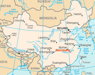
نانچانگ (الصينية: 南昌؛ Nanchang) هي عاصمة مقاطعة جيانگشي في جنوب شرق الصين.[2] اعتبارا من 2010[تحديث], a population of 5,042,565 live in the prefecture, in which 2,357,838 live in the area made up of all five urban districts.[3] Located in the north-central part of the province, it is bounded on the west by the Jiuling Mountains, and on the east by بحيرة پويانگ. Because of its strategic location connecting the prosperous East and South China, it has become a major railway hub in Southern China in recent decades.
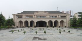
وبما أن انتفاضة نانچانگ في 1927 يـُعرِّفها تحديداً الحزب الشيوعي الحاكم بأنها "أطلقت أول رصاصة ضد الوطنيين الأشرار",[4] the current government has therefore named the city since 1949 "مدينة الأبطال", "the place where the People's Liberation Army was born", and the most widely known "place where the military banner of the People's Liberation Army was first raised". Nanchang is also a major city, appearing among the top 150 cities in the world by scientific research outputs, as tracked by the Nature Index[5] and home to Nanchang University, the key national university of “Project 211” in the city.
التاريخ
The territories encompassing modern-day Jiangxi Province—including Nanchang—was first incorporated into China during the Qin dynasty, when it was conquered from the Baiyue peoples and organized as Jiujiang Commandery (الصينية: 九江郡).[6] In 201 BC, during the Han dynasty, the city was given the Chinese name Nanchang and became the administrative seat of Yuzhang Commandery (豫章郡), and was governed by Guan Ying, one of Emperor Gaozu of Han's generals.[6] The name Nanchang means "southern flourishing", derived from a motto of developing what is now southern China that is traditionally attributed to Emperor Gaozu himself.[6]
In AD 589, during the Sui dynasty, this commandery was changed into a prefecture named Hongzhou (洪州), and after 763 it became the provincial center of Jiangxi, which was then beginning the rapid growth that by the 12th century made it the most populous province in China.
In 653 the Tengwang Pavilion was constructed, and in 675 Wang Bo wrote the classic "Tengwang Ge Xu", a poetic introductory masterpiece celebrating the building, making the building, the city, and the author himself known to literate Chinese-speaking population ever since.[7] The Pavilion has been destroyed and rebuilt several times throughout history.[8] Its present form was reconstructed in the 1980s after being destroyed in 1929 during the Chinese Civil War.[9]
In 959, under the Southern Tang regime, Nanchang was made superior prefecture and the southern capital. After the conquest by the Song regime in 981 it was reverted to the name Hongzhou. In 1164 it was renamed Longxing prefecture, which name it retained until 1368. During the Yuan dynasty it was the capital of Jiangxi Province, an area that included Guangdong as well. At the end of the Yuan (Mongol) period (1279–1368), it became a battleground between Zhu Yuanzhang, the founder of the Ming dynasty (1368–1644), and the rival local warlord, Chen Youliang. At the beginning of the 16th century it was the power base from which Zhu Chenhao, the Prince of Ning, launched a rebellion against the emperor.
During the Yuan Dynasty, it might have been the centre of porcelain trade[10]
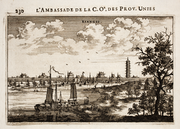
During the reign of the Wanli Emperor of the Ming dynasty, it housed relatives of the emperor who had been exiled because they were potential claimants of the imperial throne, members of the imperial family constituting about one quarter of the city's population; as a result of this, Matteo Ricci came here when trying to gain entry to Beijing.[11]
In the 1850s it suffered considerably as a result of the Taiping Rebellion (1850–64), and its importance as a commercial centre declined as the overland routes to Canton were replaced by coastal steamship services in the latter half of the 19th century. Nanchang has, however, remained the undisputed regional metropolis of Jiangxi.
On August 1, 1927, Nanchang was the site of one of a series of insurrections organized by the communists. The Nanchang Uprising, led by pro-communist Kuomintang officers under Soviet direction, succeeded in holding the city for only a few days, and provided a core of troops and a method of organization from which the People's Liberation Army (PLA) later developed.
In 1939, the Battle of Nanchang, a ferocious battle between the Chinese National Revolutionary Army and the Imperial Japan Army in the Second Sino-Japanese War took place.[12][13][14]
By 1949 Nanchang was still essentially an old-style administrative and commercial city, with little industry apart from food processing; it had a population of about 275,000. Nanchang first acquired a rail connection in 1915, only connecting to the port city of Jiujiang by the Yangtze. Several other rail links have since been opened. After World War II a line was completed to Linchuan and Gongqi in the Ru River Valley to the south-southeast.
Since 1949 Nanchang has been extensively industrialized. It is now a large-scale producer of cotton textiles and cotton yarn. Paper making is also a major industry, as is food processing (especially rice milling). Heavy industry began to gain prominence in the mid-1950s. A large thermal-power plant was installed and uses coal brought by rail from Fengcheng to the south. A machinery industry also grew up, at first mainly concentrating on the production of agricultural equipment and diesel engines. Nanchang then became a minor centre of the automotive industry in China, producing trucks and tractors and also accessories such as tires. An iron-smelting plant helping to supply local industry was installed in the later 1950s. There is also a large chemical industry, producing agricultural chemicals and insecticides as well as pharmaceuticals.
الجغرافيا
Nanchang is located in inland southeastern China, 130 km (81 mi) south of the Yangtze River and is situated on the right bank of the Gan River just below its confluence with the Jin River and some 40 km (25 mi) southwest of its discharge into بحيرة پويانگ.
المناخ
Nanchang has a monsoon-influenced humid subtropical climate (Köppen Cfa) with four distinct seasons. Winters are short and cool with occasional frosts; it begins somewhat sunny and dry but becomes progressively wetter and more overcast. Spring begins especially gloomy, and from April to June, each month has more than 220 mm (8.7 in) of rainfall. Summer is long and humid, with amongst the highest temperatures of any Chinese provincial capital, and with the sun shining close to 60 percent of the time in July and August, is the sunniest time of year. Autumn is warm to mild with the lowest rainfall levels of the year. The monthly 24-hour average temperature ranges from 5.5 °C (41.9 °F) in January to 29.5 °C (85.1 °F) in July, while the annual mean is 18.00 °C (64.4 °F). Annual precipitation stands at around 1،610 mm (63 in); with monthly percent possible sunshine ranging from 23 percent in March to 60 percent in August, the city receives 1,832 hours of sunshine annually in average. Extremes since 1951 have ranged from −9.7 °C (15 °F) on 29 December 1991 to 40.6 °C (105 °F) on 23 July 1961.[15]
| بيانات المناخ لـ نانچانگ (1981–2010) | |||||||||||||
|---|---|---|---|---|---|---|---|---|---|---|---|---|---|
| الشهر | ينا | فب | مار | أبر | ماي | يون | يول | أغس | سبت | أكت | نوف | ديس | السنة |
| القصوى القياسية °س (°ف) | 25.3 (77.5) |
28.7 (83.7) |
32.5 (90.5) |
34.6 (94.3) |
36.5 (97.7) |
37.7 (99.9) |
40.6 (105.1) |
39.7 (103.5) |
38.6 (101.5) |
35.4 (95.7) |
32.3 (90.1) |
26.1 (79.0) |
40.6 (105.1) |
| متوسط القصوى اليومية °س (°ف) | 8.8 (47.8) |
11.2 (52.2) |
15.2 (59.4) |
21.7 (71.1) |
26.9 (80.4) |
29.6 (85.3) |
33.7 (92.7) |
33.1 (91.6) |
29.1 (84.4) |
24.1 (75.4) |
17.9 (64.2) |
11.9 (53.4) |
21.9 (71.4) |
| المتوسط اليومي °س (°ف) | 5.5 (41.9) |
7.7 (45.9) |
11.4 (52.5) |
17.7 (63.9) |
22.8 (73.0) |
25.9 (78.6) |
29.5 (85.1) |
28.9 (84.0) |
25.1 (77.2) |
19.9 (67.8) |
13.7 (56.7) |
7.9 (46.2) |
18.0 (64.4) |
| متوسط الدنيا اليومية °س (°ف) | 3.0 (37.4) |
5.2 (41.4) |
8.7 (47.7) |
14.6 (58.3) |
19.7 (67.5) |
23.0 (73.4) |
26.1 (79.0) |
25.8 (78.4) |
22.2 (72.0) |
16.8 (62.2) |
10.6 (51.1) |
4.9 (40.8) |
15.1 (59.2) |
| الصغرى القياسية °س (°ف) | −7.7 (18.1) |
−9.3 (15.3) |
−1.7 (28.9) |
2.4 (36.3) |
10.0 (50.0) |
14.8 (58.6) |
18.9 (66.0) |
19.5 (67.1) |
13.3 (55.9) |
3.5 (38.3) |
−0.8 (30.6) |
−9.7 (14.5) |
−9.7 (14.5) |
| متوسط تساقط الأمطار mm (inches) | 79.0 (3.11) |
104.8 (4.13) |
176.9 (6.96) |
220.4 (8.68) |
222.9 (8.78) |
299.1 (11.78) |
139.4 (5.49) |
124.6 (4.91) |
70.4 (2.77) |
55.7 (2.19) |
76.4 (3.01) |
44.1 (1.74) |
1٬613٫7 (63.55) |
| Average precipitation days (≥ 0.1 mm) | 13.3 | 13.6 | 17.3 | 17.2 | 15.7 | 15.0 | 10.5 | 10.3 | 6.9 | 7.6 | 8.5 | 8.2 | 144.1 |
| متوسط الرطوبة النسبية (%) | 76 | 77 | 79 | 79 | 78 | 82 | 76 | 76 | 75 | 71 | 71 | 71 | 76 |
| Mean monthly ساعات سطوع الشمس | 89.0 | 83.1 | 94.2 | 125.2 | 161.4 | 159.5 | 248.6 | 233.2 | 189.5 | 168.4 | 143.0 | 137.8 | 1٬832٫9 |
| نسبة السطوع المحتمل للشمس | 28 | 27 | 23 | 30 | 36 | 39 | 59 | 60 | 50 | 47 | 46 | 44 | 41 |
| Source: China Meteorological Administration [16] | |||||||||||||
الديمغرافيا
اعتبارا من 2010[تحديث] (Census), Nanchang has a population of 5,042,565, of which about 2.3 million live in built-up (urbanized) area consists of five urban districts.[3] 37 ethnic groups were counted amongst its prefecture divisions.
الادارة
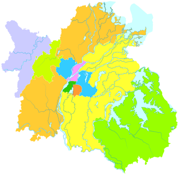
| الخريطة | |||||||||||
|---|---|---|---|---|---|---|---|---|---|---|---|
| Division code[17] | English | Chinese | Pinyin | Area in km2[18] | Seat | Postal code | Subdivisions[19] | ||||
| Subdistricts | Towns | Townships | Residential communities | Villages | |||||||
| 360100 | Nanchang | 南昌市 | Nánchāng Shì | 7194[20] | Donghu District (Honggutan N.A.) | 330000 | 30 | 49 | 31 | 625 | 1161 |
| 360102 | Donghu District | 东湖区 | Dōnghú Qū | 30 | Gongyuan Subdistrict (公园街道) | 330000 | 10 | 159 | 21 | ||
| 360103 | Xihu District | 西湖区 | Xīhú Qū | 43 | Chaoyangzhou Subdistrict (朝阳洲街道) | 330000 | 10 | 1 | 136 | 13 | |
| 360104 | Qingyunpu District | 青云谱区 | Qīngyúnpǔ Qū | 40 | Sanjiadian Subdistrict (三家店街道) | 330000 | 5 | 1 | 63 | 12 | |
| 360105 | Wanli District | 湾里区 | Wānlǐ Qū | 254 | Zhaoxian (招贤镇) | 330000 | 2 | 4 | 12 | 35 | |
| 360111 | Qingshanhu District | 青山湖区 | Qīngshānhú Qū | 250 | Jingdong (京东镇) | 330000 | 3 | 6 | 116 | 101 | |
| 360112 | Xinjian District | 新建区 | Xīnjiàn Qū | 2160 | Changleng (长堎镇) | 330100 | 10 | 9 | 39 | 300 | |
| 360121 | Nanchang County | 南昌县 | Nánchāng Xiàn | 1811 | Liantang (莲塘镇) | 330200 | 11 | 7 | 47 | 311 | |
| 360123 | Anyi County | 安义县 | Ānyì Xiàn | 660 | Longjin (龙津镇) | 330500 | 7 | 3 | 16 | 105 | |
| 360124 | Jinxian County | 进贤县 | Jìnxián Xiàn | 1946 | Minhe (民和镇) | 331700 | 9 | 2 | 37 | 263 | |
- Honggutan New District (红谷滩新区) is an economic management area and not a formal administrative division.
الاقتصاد
Nanchang is a regional hub for agricultural production in Jiangxi province. The yield of grain was 16.146 million tons in 2000. Products such as rice and oranges are economic staples. The Ford Motor Company has a plant in Nanchang, assembling the Ford Transit van as part of the Jiangling Motor joint venture.[21] Many of its industry revolves around aircraft manufacturing, automobile manufacturing, metallurgy, electro-mechanics, textile, chemical engineering, traditional Chinese medicine, pharmaceuticals and others.[22]
The GDP of Nanchang in 2008 was 166 billion Yuan (24.3 billion USD). The GDP per capita was 36,105 Yuan (5,285 USD). The total value of imports and exports was 3.4 billion US dollars. The total financial revenue was 23 billion Yuan.[23]
المعالم
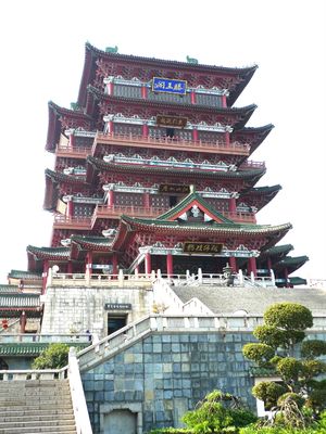

- Tengwang Pavilion, a towering pavilion dating to 653,on the east bank of the Gan River and is one of "أبراج الصين الأربعة العظمى"
- بحيرة پويانگ, the largest fresh water lake in China, it is also called "the Migrator Birds Paradise".
- Star of Nanchang, which was the world's tallest Ferris wheel from 2006-2008, in Honggu New District[24]
- Qiushui Square, established on 28 January 2004 with the largest music fountain group with music in Asia.[بحاجة لمصدر]
- Jiangxi Provincial Museum and Bada Shanren Exhibition Hall
- People's Park, the largest park in downtown Nanchang[25]
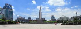
- Bayi Square and Memorial, at the center of Nanchang, commemorates the Nanchang Uprising of 8/1 (Ba Yi in Mandarin) in 1927, which led to the formation of modern China in 1949.
انظر أيضاً
الهامش
- ^ http://www.citypopulation.de/php/china-jiangxi-admin.php
- ^ "Illuminating China's Provinces, Municipalities and Autonomous Regions". PRC Central Government Official Website. Retrieved 2014-05-17.
- ^ أ ب "南昌市2010年第六次全国人口普查主要数据公报". 江西省统计局 (in Chinese). 南昌市统计局. 20 March 2012. Retrieved 23 July 2015.
{{cite web}}: CS1 maint: unrecognized language (link) - ^ Schwartz, Benjamin, Chinese Communism and the Rise of Mao, Harper & Row (New York: 1951), p. 93.
- ^ "Leading 200 science cities | Nature Index 2022 Science Cities | Supplements | Nature Index". www.nature.com (in الإنجليزية). Retrieved 2022-11-27.
- ^ أ ب ت 中国古今地名大词典 [Dictionary of Chinese Place-names Ancient and Modern]. Shanghai: Shanghai Lexicographical Publishing House. 2006. p. 2080. ISBN 9787532617432.
- ^ Wang: 236-246.
- ^ Wang: 1.
- ^ Wang: 31.
- ^ "Wang Dayuan - Singapore History". eresources.nlb.gov.sg. Retrieved 2021-04-01.
- ^ Mary Laven, Mission to China: Matteo Ricci and the Jesuit Encounter with the East, ISBN 0-571-22517-9, 2011, p. 103
- ^ Hsu Long-hsuen and Chang Ming-kai, History of the Sino-Japanese War (1937–1945), 2nd Ed., 1971. Translated by Wen Ha-hsiung, Chung Wu Publishing; 33, 140th Lane, Tung-hwa Street, Taipei, Taiwan Republic of China. pp. 293-300 Map. 14-15
- ^ Peattie, M., Drea, E. & Ven, H. (2011). The battle for China : essays on the military history of the Sino-Japanese War of 1937-1945. Stanford, Calif: Stanford University Press.
- ^ http://surfcity.kund.dalnet.se/sino-japanese.htm Archived 2015-08-13 at the Wayback Machine Sino-Japanese Air War 1937–45
- ^ "Archived copy". Archived from the original on 2013-03-18. Retrieved 2013-02-18.
{{cite web}}: Unknown parameter|deadurl=ignored (|url-status=suggested) (help)CS1 maint: archived copy as title (link) - ^ 中国气象局 国家气象信息中心 (in Chinese). China Meteorological Administration. Archived from the original on 2013-03-18. Retrieved 2010-05-04.
{{cite web}}: Unknown parameter|deadurl=ignored (|url-status=suggested) (help)CS1 maint: unrecognized language (link) - ^ 国家统计局统计用区划代码 Archived 2013-04-05 at the Wayback Machine
- ^ 《贵阳统计年鉴2011》
- ^ 《中国民政统计年鉴2011》
- ^ 国土资源局数字为7432.18平方公里
- ^ "Jiangling Motors Corporation, Ltd. website".
- ^ [1] Archived أبريل 14, 2010 at the Wayback Machine
- ^ "Jiangxi". Unescap.org. Archived from the original on 2004-06-26. Retrieved 2012-01-16.
{{cite web}}: Unknown parameter|dead-url=ignored (|url-status=suggested) (help) - ^ "China claims world's largest Ferris wheel - Boston.com". Archived from the original on May 1, 2007.
{{cite news}}: Unknown parameter|deadurl=ignored (|url-status=suggested) (help) - ^ 南昌-人民公园 [People's Park, Nanchang] (in Chinese). Xinhua. 2008-04-01. Retrieved 2014-05-04.
{{cite web}}: CS1 maint: unrecognized language (link)
- Wang, Qiaolin (الصينية: 王巧林; پنين: Wáng Qiǎolín) et al. 1996. Jiangnan Famous Site: The Pavilion of Prince Teng (الصينية المبسطة: 江南名胜 滕王阁; الصينية التقليدية: 江南名勝 滕王閣; پنين: Jiāngnán Míngshèng Téngwáng Gé). Baihuazhou Literary Press (الصينية: 百花洲文艺出版社; پنين: Báihuāzhōu Wényì Chūbǎnshè). 247 pages. ISBN 7-80579-797-8.
وصلات خارجية
- Pages using gadget WikiMiniAtlas
- CS1 uses الصينية-language script (zh)
- CS1 errors: unsupported parameter
- Short description is different from Wikidata
- Articles containing صينية-language text
- Pages using multiple image with auto scaled images
- Lang and lang-xx template errors
- Pages using infobox settlement with possible nickname list
- Coordinates on Wikidata
- Articles containing Chinese-language text
- مقالات فيها عبارات متقادمة منذ 2010
- جميع المقالات التي فيها عبارات متقادمة
- Articles with unsourced statements from May 2014
- Articles containing simplified Chinese-language text
- Articles containing traditional Chinese-language text
- نانچانگ
- Cities in Jiangxi
- Prefecture-level divisions of Jiangxi
- عواصم المقاطعات في الصين
- تأسيسات القرن الأول ق.م. في الصين
- Populated places established in the 1st century BC
- 201 ق.م.
- تأسيسات عقد 200 ق.م.
- صفحات مع الخرائط
