سان هواكين ڤالي
| سان هواكين ڤالي San Joaquin Valley | |
|---|---|
إسپانية: Valle de San Joaquín | |
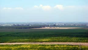
 سان هواكين ڤالي | |
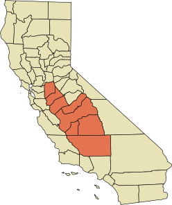
 A map of the counties encompassing the San Joaquin Valley ecoregion | |
| الجغرافيا | |
| الموقع | California, United States |
| التعداد centers | Stockton, Tulare, Porterville, Modesto, Turlock, Merced, Fresno, Visalia, Bakersfield, Clovis |
| يحد | Sierra Nevada (east), Sacramento–San Joaquin River Delta (north), Coast Range, San Francisco Bay (west), Tehachapi Mountains (south) |
| الإحداثيات | 36°37′44″N 120°11′06″W / 36.62889°N 120.18500°W |
| يتخللها | Interstate 5, State Route 99 |
| الأنهار | نهر سان هواكين |
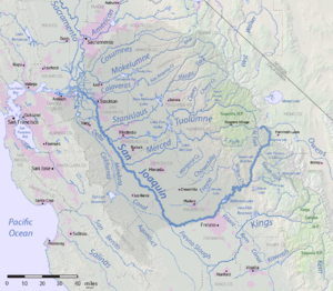
سان هواكين ڤالي (San Joaquin Valley ؛ /ˌsæn hwɑːˈkiːn/ SAN whah-KEEN) is the area of the Central Valley of the U.S. state of California that lies south of the Sacramento–San Joaquin River Delta and is drained by the San Joaquin River. It comprises seven counties of Northern and one of Southern California, including, in the north, all of San Joaquin and Kings counties, most of Stanislaus, Merced, and Fresno counties, and parts of Madera and Tulare counties, along with a majority of Kern County, in Southern California.[1] Although a majority of the valley is rural, it does contain cities such as Fresno, Bakersfield, Stockton, Modesto, Turlock, Tulare, Porterville, Visalia, Merced, and Hanford.
San Joaquin Valley was originally inhabited by the Yokuts and Miwok peoples. The first European to enter the valley was Pedro Fages in 1772.[2]
. . . . . . . . . . . . . . . . . . . . . . . . . . . . . . . . . . . . . . . . . . . . . . . . . . . . . . . . . . . . . . . . . . . . . . . . . . . . . . . . . . . . . . . . . . . . . . . . . . . . . . . . . . . . . . . . . . . . . . . . . . . . . . . . . . . . . . . . . . . . . . . . . . . . . . . . . . . . . . . . . . . . . . . .
المدن والمقاطعات
Cities with more than 500,000 inhabitants
Cities with 100,000 to 500,000 inhabitants
Cities with 20,000 to 100,000 inhabitants
Cities with fewer than 20,000 inhabitants
- Arvin
- Avenal
- Badger
- Caruthers
- Chowchilla
- Coalinga
- Dos Palos
- Earlimart
- East Porterville
- Exeter
- Farmersville
- Firebaugh
- Grayson
- Gustine
- Hilmar
- Hughson
- Ivanhoe
- Kerman
- Kettleman City
- Kingsburg
- Lamont
- Lathrop
- Laton
- Lemon Cove
- Lindsay
- Livingston
- Lost Hills
- McFarland
- Mendota
- Newman
- Orange Cove
- Parlier
- Pixley
- Seville
- Stevinson
- Strathmore
- Taft
- Three Rivers
- Waterford
- Westley
- Woodlake
- Yettem
في الثقافة الشعبية
- The operations of the fictional Sons of Anarchy Motorcycle Club in the hit FX television show Sons of Anarchy, are centered in San Joaquin Valley, often referred to as "Sanwa".
- The surviving stronghold of civilization on the West Coast in popular Science-Fiction book Lucifer's Hammer.[مطلوب توضيح]
انظر أيضاً
- Groundwater-related subsidence
- John Buttencourt Avila, "father of the sweet potato industry."
- List of California rivers
- San Joaquin (soil)
- Water in California
وصلات خارجية
المراجع
- ^ "San Joaquin Valley Fact Sheet". Valley Clean Air Now. Archived from the original on October 22, 2014. Retrieved October 18, 2014.
Seven counties comprise the San Joaquin Valley, including all of Kings County, most of Fresno, Kern, Merced, and Stanislaus counties, and portions of Madera, San Luis Obispo, Tulare counties
{{cite web}}: Unknown parameter|deadurl=ignored (|url-status=suggested) (help) - ^ Capace, Nancy (1999). Encyclopedia of California. North American Book Dist LLC. Page 410. ISBN 9780403093182.
- Pages using gadget WikiMiniAtlas
- CS1 errors: unsupported parameter
- Articles containing إسپانية-language text
- Pages using Lang-xx templates
- Coordinates not on Wikidata
- جميع الصفحات التي تحتاج تنظيف
- مقالات بالمعرفة تحتاج توضيح from May 2016
- Pages with empty portal template
- Portal-inline template with redlinked portals
- سان هواكين ڤالي
- وديان كاليفورنيا
- مناطق كاليفورنيا
- نهر سان هواكين
- Valleys of Fresno County, California
- Valleys of Kern County, California
- Valleys of Kings County, California
- Valleys of Madera County, California
- Valleys of Merced County, California
- Valleys of San Joaquin County, California
- Valleys of Stanislaus County, California
- Valleys of Tulare County, California
- Geography of the Central Valley (California)
