ردنگ، كاليفورنيا
Redding, California | |
|---|---|
| City of Redding | |
 | |
| الكنية: "The Jewel of Northern California"[1] | |
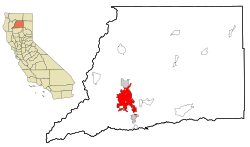
 Location of Redding in Shasta County, California | |
| الإحداثيات: 40°35′N 122°22′W / 40.583°N 122.367°W | |
| Country | الولايات المتحدة |
| State | |
| County | Shasta |
| Incorporated | October 4, 1887 |
| أسسها | Pierson B. Reading |
| الحكومة | |
| • النوع | Council-manager |
| • City council | Mayor Kristen Schreder Brent Weaver Francie Sullivan Julie Winter Adam McElvain |
| • City manager | Barry Tippin |
| المساحة | |
| • الإجمالي | 61٫17 ميل² (158٫44 كم²) |
| • البر | 59٫65 ميل² (154٫49 كم²) |
| • الماء | 1٫53 ميل² (3٫96 كم²) 2.50% |
| المنسوب | 564 ft (172 m) |
| التعداد (2010) | |
| • الإجمالي | 89٬861 |
| • Estimate (2016)[4] | 91٬808 |
| • الكثافة | 1٬539٫19/sq mi (594٫28/km2) |
| صفة المواطن | Reddingite |
| منطقة التوقيت | UTC−8 (Pacific Time Zone) |
| • الصيف (التوقيت الصيفي) | UTC−7 (PDT) |
| ZIP codes | 96001 – 96003, 96049, 96099 |
| Area code | 530 |
| FIPS code | 06-59920 |
| GNIS feature IDs | 277582, 2411531 |
| الموقع الإلكتروني | Official website |
ردنگ هي مقعد المقاطعة في مقاطعة شاستا، كاليفورنيا ويمر بها نهر ساكرامينتو وكذلك خط السريع عابر الولايات 5.
. . . . . . . . . . . . . . . . . . . . . . . . . . . . . . . . . . . . . . . . . . . . . . . . . . . . . . . . . . . . . . . . . . . . . . . . . . . . . . . . . . . . . . . . . . . . . . . . . . . . . . . . . . . . . . . . . . . . . . . . . . . . . . . . . . . . . . . . . . . . . . . . . . . . . . . . . . . . . . . . . . . . . . . .
أصل الاسم

الديمغرافيا
| التعداد التاريخي | |||
|---|---|---|---|
| التعداد | Pop. | %± | |
| 1880 | 600 | — | |
| 1890 | 1٬821 | 203٫5% | |
| 1900 | 2٬946 | 61٫8% | |
| 1910 | 3٬572 | 21٫2% | |
| 1920 | 2٬962 | −17٫1% | |
| 1930 | 4٬188 | 41٫4% | |
| 1940 | 8٬109 | 93٫6% | |
| 1950 | 10٬256 | 26٫5% | |
| 1960 | 12٬773 | 24٫5% | |
| 1970 | 16٬659 | 30٫4% | |
| 1980 | 42٬103 | 152٫7% | |
| 1990 | 66٬462 | 57٫9% | |
| 2000 | 80٬865 | 21٫7% | |
| 2010 | 89٬861 | 11٫1% | |
| 2016 (تق.) | 91٬808 | [4] | 2٫2% |
| U.S. Decennial Census[5] | |||
المناخ
| Climate data for Redding Municipal Airport (1981–2010) | |||||||||||||
|---|---|---|---|---|---|---|---|---|---|---|---|---|---|
| Month | Jan | Feb | Mar | Apr | May | Jun | Jul | Aug | Sep | Oct | Nov | Dec | Year |
| Record high °F (°C) | 80 (27) |
83 (28) |
88 (31) |
96 (36) |
106 (41) |
117 (47) |
118 (48) |
115 (46) |
116 (47) |
105 (41) |
88 (31) |
78 (26) |
118 (48) |
| Mean daily maximum °F (°C) | 55.0 (12.8) |
59.7 (15.4) |
64.5 (18.1) |
70.5 (21.4) |
80.8 (27.1) |
90.2 (32.3) |
98.4 (36.9) |
96.6 (35.9) |
90.4 (32.4) |
77.8 (25.4) |
62.5 (16.9) |
54.5 (12.5) |
75.1 (23.9) |
| Daily mean °F (°C) | 45.7 (7.6) |
49.5 (9.7) |
53.7 (12.1) |
58.3 (14.6) |
67.3 (19.6) |
75.9 (24.4) |
82.2 (27.9) |
79.8 (26.6) |
74.1 (23.4) |
63.6 (17.6) |
51.7 (10.9) |
45.4 (7.4) |
62.3 (16.8) |
| Mean daily minimum °F (°C) | 36.5 (2.5) |
39.3 (4.1) |
42.9 (6.1) |
46.1 (7.8) |
53.8 (12.1) |
61.6 (16.4) |
66.0 (18.9) |
63.0 (17.2) |
57.7 (14.3) |
49.4 (9.7) |
40.9 (4.9) |
36.3 (2.4) |
49.2 (9.6) |
| Record low °F (°C) | 16 (−9) |
21 (−6) |
28 (−2) |
28 (−2) |
34 (1) |
42 (6) |
53 (12) |
50 (10) |
40 (4) |
33 (1) |
22 (−6) |
16 (−9) |
16 (−9) |
| Average precipitation inches (mm) | 5.96 (151) |
5.51 (140) |
4.37 (111) |
2.48 (63) |
1.85 (47) |
0.69 (18) |
0.09 (2.3) |
0.18 (4.6) |
0.64 (16) |
2.10 (53) |
4.48 (114) |
6.27 (159) |
34.62 (878.9) |
| Average snowfall inches (cm) | 1.4 (3.6) |
0.6 (1.5) |
0.2 (0.51) |
0 (0) |
0 (0) |
0 (0) |
0 (0) |
0 (0) |
0 (0) |
0 (0) |
0.1 (0.25) |
3.2 (8.1) |
5.5 (13.96) |
| Average precipitation days | 13.1 | 8.7 | 12.3 | 7.9 | 7.2 | 4.0 | 0.6 | 0.9 | 2.1 | 4.1 | 6.8 | 10.2 | 77.9 |
| Mean monthly sunshine hours | 226 | 256 | 312 | 351 | 395 | 423 | 451 | 421 | 338 | 314 | 251 | 204 | 3٬942 |
| Source: [6] | |||||||||||||
المراجع
- ^ "Redding, CA Real Estate and Living". Reddingshomebuyers.com (in الإنجليزية). Retrieved 2018-07-27.
- ^ "2016 U.S. Gazetteer Files". United States Census Bureau. Retrieved Jun 28, 2017.
- ^ "Redding". نظام معلومات الأسماء الجغرافية، المسح الجيولوجي الأمريكي. Retrieved November 22, 2014.
- ^ أ ب "Population and Housing Unit Estimates". Retrieved June 9, 2017.
- ^ "Census of Population and Housing". Census.gov. Archived from the original on May 12, 2015. Retrieved June 4, 2015.
{{cite web}}: Unknown parameter|deadurl=ignored (|url-status=suggested) (help) - ^ "NOWData – NOAA Online Weather Data". Retrieved August 28, 2017.
وصلات خارجية
- Official website
- Images of Redding from the Eastman's Originals Collection, Special Collections Dept., University of California, Davis.
- "Redding, California". C-SPAN Cities Tour. May 2017.
. . . . . . . . . . . . . . . . . . . . . . . . . . . . . . . . . . . . . . . . . . . . . . . . . . . . . . . . . . . . . . . . . . . . . . . . . . . . . . . . . . . . . . . . . . . . . . . . . . . . . . . . . . . . . . . . . . . . . . . . . . . . . . . . . . . . . . . . . . . . . . . . . . . . . . . . . . . . . . . . . . . . . . . .
الموقع الجغرافي
قالب:Sacramento Valley قالب:Shasta Cascade قالب:Shasta County, California خطأ لوا في وحدة:Authority_control على السطر 278: attempt to call field '_showMessage' (a nil value).
- Pages using gadget WikiMiniAtlas
- CS1 errors: unsupported parameter
- Short description is different from Wikidata
- Coordinates on Wikidata
- Pages using US Census population needing update
- Redding, California
- 1887 establishments in California
- Cities in Shasta County, California
- County seats in California
- Geography of the Sacramento Valley
- مدن وبلدات مشهرة في كاليفورنيا
- Logging communities in the United States
- Populated places established in 1887
- Populated places on the Sacramento River
- Shasta Cascade
- مدن كاليفورنيا


