بروج
Bruges
Brugge (هولندية) | |||||||||||||||||||
|---|---|---|---|---|---|---|---|---|---|---|---|---|---|---|---|---|---|---|---|
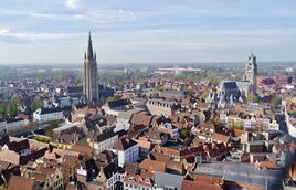
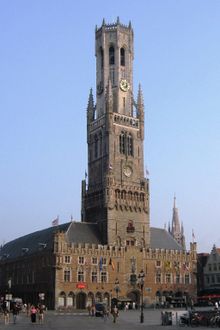
Southwestern view from the Belfry, with the Church of Our Lady and St. Salvator's Cathedral in the background Canal view with Belfry in the background | |||||||||||||||||||
| الإحداثيات: 51°12′32″N 03°13′27″E / 51.20889°N 3.22417°E | |||||||||||||||||||
| البلد | بلجيكا | ||||||||||||||||||
| Community | Flemish Community | ||||||||||||||||||
| المنطقة | المنطقة الفلمنكية | ||||||||||||||||||
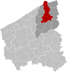
| المقاطعة | West Flanders | ||||||||||||||||||
| Arrondissement | Bruges | ||||||||||||||||||
| الحكومة | |||||||||||||||||||
| • العمدة | Dirk De fauw (CD&V) | ||||||||||||||||||
| • الحزب الحاكم | CD&V, Vooruit, Open VLD | ||||||||||||||||||
| المساحة | |||||||||||||||||||
| • الإجمالي | 138٫40 كم² (53٫44 ميل²) | ||||||||||||||||||
| التعداد (2018-01-01) | |||||||||||||||||||
| • الإجمالي | 118٬284 | ||||||||||||||||||
| • الكثافة | 850/km2 (2٬200/sq mi) | ||||||||||||||||||
| Postal codes | 8000, 8200, 8310, 8380 | ||||||||||||||||||
| Area codes | 050 | ||||||||||||||||||
| الموقع الإلكتروني | visitbruges.be | ||||||||||||||||||
| |||||||||||||||||||
Logo of Brugge | |||||||||||||||||||
بروج (هولندية: Brugge؛ إنگليزية: Bruges) مدينة بلجيكية ذات جمال طبيعي أخاذ، يبلغ عدد سكانها 116,724نسمة. تقع المدينة على بعد 90كم شمال غربي بروكسل. انظر: بلجيكا. تشتهر بروج بمنتجات الدانتيل والمنسوجات والمعادن. يعمل معظم سكان المدينة في صناعة الخمور وتقطيرها وصناعة بناء السفن وإصلاحها والسياحة.
يعني اسم هذه المدينة القديمة مدينة الجسور. يتخلل العديد من الجسور شبكات القنوات الجارية بها، تجذب مباني هذه المدينة التي يرجع تاريخها إلى العصور الوسطى بلوحاتها التشكيلية ومنحوتاتها الجميلة الزوار، ولقاعة السوق التي بنيت في القرن الثالث عشر الميلادي برج جرسي به 47 جرسًا. أما قاعة المدينة التي بنيت على طراز العمارة القوطي فقد بنيت في القرن الرابع عشر الميلادي.
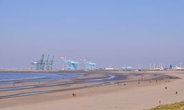
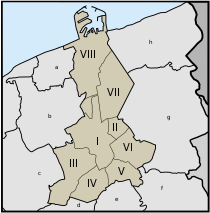
The area of the whole city amounts to more than 14,099 hectares (140.99 km2; 54.44 sq miles), including 1,075 hectares off the coast, at Zeebrugge (from Brugge aan zee,[1] meaning 'Bruges by the Sea').[2] The historic city centre is a prominent World Heritage Site of UNESCO. It is oval and about 430 hectares in size. The city's total population is 117,073 (1 January 2008),[3] of whom around 20,000 live in the city centre. The metropolitan area, including the outer commuter zone, covers an area of 616 km2 (238 sq mi) and had a total of 255,844 inhabitants as of 1 January 2008.[4]
Along with a few other canal-based northern cities, such as Amsterdam and Saint Petersburg, it is sometimes referred to as the Venice of the North. Bruges has significant economic importance, thanks to its port, and was once one of the world's chief commercial cities.[5][6] Bruges is a major tourism destination within Belgium and is well known as the seat of the College of Europe, a university institute for European studies.[7]
أصل الاسم
أقدم ذِكر لاسم الموقع هو Bruggas, Brvggas or Brvccia in AD 840–875. Afterwards, it appears as Bruciam and Bruociam (892); as Brutgis uico (late ninth century); as in portu Bruggensi (ح. 1010); as Bruggis (1012); as Bricge in the Anglo-Saxon Chronicle (1037); as Brugensis (1046); as Brycge in the Anglo-Saxon Chronicle (1049–1052); as Brugias (1072); as Bruges (1080–1085); as Bruggas (ح. 1084); as Brugis (1089); and as Brugge (1116).[8]
The name probably derives from the Old Dutch for 'bridge': brugga. Also compare Middle Dutch brucge, brugge (or brugghe, brigghe, bregghe, brogghe), and modern Dutch bruggehoofd ('bridgehead') and brug ('bridge').[9] The form brugghe would be a southern Dutch variant.[10] The Dutch word and the English bridge both derive from Proto-Germanic *brugjō-.[11]
التاريخ
الأصول
Bruges was a location of coastal settlement during prehistory. This Bronze Age and Iron Age settlement are unrelated to medieval city development. In the Bruges area, the first fortifications were built after Julius Caesar's conquest of the Menapii in the first century BC, to protect the coastal area against pirates. The Franks took over the whole region from the Gallo-Romans around the fourth century and administered it as the Pagus Flandrensis. The Viking incursions of the ninth century prompted Count Baldwin I of Flanders to reinforce the Roman fortifications; trade soon resumed with England and Scandinavia. Early medieval habitation starts in the ninth and tenth centuries on the Burgh terrain, probably with a fortified settlement and church.[12]
العصر الذهبي (القرون 12 - 15)

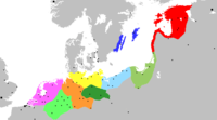
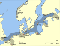
أسست مدينة بروج عام 865م. ازدهرت المدينة بين عامي 1240م و1426م وكانت أهم مدينة في أوروبا قاطبة آنذاك. تبادلت التجارة مع العصبة الهنزية والبندقية.
الجغرافيا
المعالم
| Historic Centre of Bruges | |
|---|---|
| أسس الاختيار | Cultural: ii, iv, vi |
| المراجع | 996 |
| Inscription | 2000 (24th Session) |
Bridge at Bruges, (ca. 1919)
by Louis Dewis.
الثقافة والفن
المسارح وقاعات الموسيقى
پانورامات
المصادر
- ^ Degraer, Hugo (1968). Repertorium van de pers in West-Vlaanderen 1807-1914. Nauwelaerts, University of Michigan. p. 143., Snippet pages 143
- ^ Boniface, Brian G.; Cooper, Christopher P. (2001). Worldwide destinations: the geography of travel and tourism (3 ed.). Butterworth-Heinemann. p. 140. ISBN 978-0-7506-4231-6., page 140
- ^ Statistics Belgium; Population de droit par commune au 1 janvier 2008 (excel-file) Archived 26 يناير 2009 at the Wayback Machine Population of all municipalities in Belgium, as of 1 January 2008. Retrieved on 19 October 2008.
- ^ Statistics Belgium; De Belgische Stadsgewesten 2001 (pdf-file) Archived 29 أكتوبر 2008 at the Wayback Machine Definitions of metropolitan areas in Belgium. The metropolitan area of Bruges is divided into three levels. First, the central agglomeration (agglomeratie), which in this case is Bruges municipality, with 117,073 inhabitants (1 January 2008). Adding the closest surroundings (banlieue) gives a total of 166,502. And, including the outer commuter zone (forensenwoonzone) the population is 255,844. Retrieved on 19 October 2008.
- ^ Dunton, Larkin (1896). The World and Its People. Silver, Burdett. p. 158.
- ^ Charlier, Roger H. (2005). "Grandeur, Decadence, and Renaissance". Journal of Coastal Research: 425–447. JSTOR 25737011.
Rise, fall, and resurrection make up the life story of Bruges, a city that glittered in Northern Europe with as much panache as Venice did in the Mediterranean World.
- ^ Fleming, Adam (25 October 2013). "College of Europe in Bruges: Home of Thatcher speech". BBC. Retrieved 10 July 2015.
- ^ Maurits Gysseling, Toponymisch woordenboek van België, Nederland, Luxemburg, Noord-Frankrijk en West-Duitsland (vóór 1226), Brussel 1960, p. 195.
- ^ "brug". etymologiebank.nl. 5 April 1922. Retrieved 20 February 2014.
- ^ M. Philippa, F. Debrabandere, A. Quak, T. Schoonheim & N. van der Sijs (2003–2009), Etymologisch woordenboek van het Nederlands, AUP: Amsterdam.
- ^ Morris, William, ed. (1969). "Appendix, "Indo-European Roots"". American Heritage Dictionary of the English Language. American Heritage Publishing Co. p. 1510. ISBN 9780395090664.
- ^ Boogaart, Thomas A. (1 January 2004). An Ethnogeography of Late Medieval Bruges. Edwin Mellen Press. ISBN 9780773464216.
وصلات خارجية
 Media related to بروج at Wikimedia Commons
 بروج travel guide from Wikivoyage
- Official website (in إنگليزية)
 Texts on Wikisource:
- "Bruges". Encyclopædia Britannica. Vol. 4 (9th ed.). 1878. pp. 395–396.
- Chisholm, Hugh, ed. (1911). . دائرة المعارف البريطانية. Vol. 4 (eleventh ed.). Cambridge University Press. pp. 678–679.
{{cite encyclopedia}}: Cite has empty unknown parameter:|coauthors=(help) - "Bruges". Encyclopedia Americana. 1920.
قالب:Populated places in Bruges قالب:Municipalities in West Flanders
- Pages using gadget WikiMiniAtlas
- Articles containing هولندية-language text
- Articles containing فرنسية-language text
- CS1: Julian–Gregorian uncertainty
- Short description is different from Wikidata
- Pages using multiple image with auto scaled images
- Coordinates on Wikidata
- Pages using Lang-xx templates
- Articles containing إنگليزية-language text
- Articles containing لاتينية-language text
- Articles containing إنگليزية القديمة (ح. 450-1100)-language text
- Articles containing undetermined-language text
- Articles containing Middle Dutch (ca. 1050-1350)-language text
- Articles containing الجرمانية الأولية-language text
- Pages using infobox UNESCO World Heritage Site with unknown parameters
- Official website different in Wikidata and Wikipedia
- Articles with إنگليزية-language sources (en)
- Wikipedia articles incorporating a citation from EB9
- مقالات المعرفة المحتوية على معلومات من دائرة المعارف البريطانية طبعة 1911
- بروج
- بلديات غرب الفلاندرز
- مدن وبلدات في الفلاندرز
- موانئ بلجيكا
- موانئ بحر الشمال
- مواقع التراث العالمي في بلجيكا
- محطات تجارية للعصبة الهانزية
