هيماتشال برادش
Himachal Pradesh | |||||||||||||||||||||||||
|---|---|---|---|---|---|---|---|---|---|---|---|---|---|---|---|---|---|---|---|---|---|---|---|---|---|
| State of Himachal Pradesh | |||||||||||||||||||||||||
| أصل الاسم: "Land of the snow-clad mountains" | |||||||||||||||||||||||||
| الكنية: "Mountain State" | |||||||||||||||||||||||||
| الشعار: Satyameva Jayate (Truth alone triumphs) | |||||||||||||||||||||||||
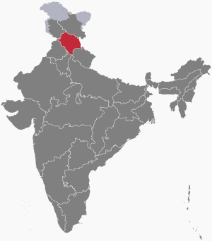 Location of Himachal Pradesh in India | |||||||||||||||||||||||||
| الإحداثيات: 31°6′12″N 77°10′20″E / 31.10333°N 77.17222°E | |||||||||||||||||||||||||
| Country | |||||||||||||||||||||||||
| Region | North India | ||||||||||||||||||||||||
| Before was | Punjab States Agency | ||||||||||||||||||||||||
| As State | 25 January 1971 | ||||||||||||||||||||||||
| Formation | 1 November 1956 | ||||||||||||||||||||||||
| Capital | Shimla Dharamshala (Winter) | ||||||||||||||||||||||||
| Largest City | Shimla | ||||||||||||||||||||||||
| Districts | 12 | ||||||||||||||||||||||||
| الحكومة | |||||||||||||||||||||||||
| • الكيان | Government of Himachal Pradesh | ||||||||||||||||||||||||
| • Governor | Shiv Pratap Shukla[1] | ||||||||||||||||||||||||
| • Chief Minister | Sukhvinder Singh Sukhu (INC) | ||||||||||||||||||||||||
| • Deputy Chief Minister | Mukesh Agnihotri (INC) | ||||||||||||||||||||||||
| State Legislature | Unicameral | ||||||||||||||||||||||||
| • Assembly | Himachal Pradesh Legislative Assembly[2] (68 seats) | ||||||||||||||||||||||||
| National Parliament | Parliament of India | ||||||||||||||||||||||||
| • Rajya Sabha | 3 seats | ||||||||||||||||||||||||
| • Lok Sabha | 4 seats | ||||||||||||||||||||||||
| High Court | Himachal Pradesh High Court | ||||||||||||||||||||||||
| المساحة | |||||||||||||||||||||||||
| • الإجمالي | 55٬673 كم² (21٬495 ميل²) | ||||||||||||||||||||||||
| ترتيب المساحة | 18th | ||||||||||||||||||||||||
| الأبعاد | |||||||||||||||||||||||||
| • الطول | 300 km (200 mi) | ||||||||||||||||||||||||
| • العرض | 200 km (100 mi) | ||||||||||||||||||||||||
| المنسوب | 350 m (1٬150 ft) | ||||||||||||||||||||||||
| أعلى منسوب | 6٬813 m (22٬352 ft) | ||||||||||||||||||||||||
| أوطى منسوب | 232 m (761 ft) | ||||||||||||||||||||||||
| التعداد (2011)[5] | |||||||||||||||||||||||||
| • الإجمالي | |||||||||||||||||||||||||
| • الترتيب | 21st | ||||||||||||||||||||||||
| • الكثافة | 123/km2 (320/sq mi) | ||||||||||||||||||||||||
| • Urban | 10٫03% | ||||||||||||||||||||||||
| • Rural | 89٫97% | ||||||||||||||||||||||||
| صفة المواطن | Himachalis | ||||||||||||||||||||||||
| Language | |||||||||||||||||||||||||
| • Official | هندي | ||||||||||||||||||||||||
| • Additional Official | سنسكريت | ||||||||||||||||||||||||
| • Official Script | Devanagari script | ||||||||||||||||||||||||
| GDP | |||||||||||||||||||||||||
| • Total (2024–2025) | ▲₹2٫27 lakh crore (28 بليون US$) | ||||||||||||||||||||||||
| • Rank | 22nd | ||||||||||||||||||||||||
| • Per capita | ▲₹286٬401 (US$3٬600) (14th) | ||||||||||||||||||||||||
| منطقة التوقيت | UTC+05:30 (IST) | ||||||||||||||||||||||||
| ISO 3166 code | IN-HP | ||||||||||||||||||||||||
| Vehicle registration | HP | ||||||||||||||||||||||||
| HDI (2021) | ▲ 0.703 High [6] (7th) | ||||||||||||||||||||||||
| Literacy (2011) | |||||||||||||||||||||||||
| Sex ratio (2011) | 972♀/1000 ♂ (32nd) | ||||||||||||||||||||||||
| الموقع الإلكتروني | himachal | ||||||||||||||||||||||||
| |||||||||||||||||||||||||
هيماچال پرادش (Himachal Pradesh ؛ بالهندية: हिमाचल प्रदेश، /hɪˌmɑːtʃəl prəˈdɛʃ/؛ هندي: [ɦɪˈmäːtʃəl pɾəˈd̪eːʃ] [[:Media:Himachal.ogg|]] ؛ حرفياً "ولاية الجبال المغطاة بالثلج"[9])، هي ولاية جبلية تقع في أقصى شمالي الهند. وتقع في غرب الهيمالايا، وهي واحدة من الولايات الجبلية الثلاثة عشر، وتتسم بالتضاريس الحادة من قمم عِدة وأنظمة أنهار كثيفة. هيماتشل پردش هي الولاية الأقصى شمالاً في الهند وتتشارك الحدود مع أقاليم الاتحاد جمو وكشمير و لداخ إلى الشمال، وولايات الپنجاب إلى الغرب، هاريانا إلى الجنوب الغربي، أوتاراخند إلى الجنوب الشرقي وحدود ضيقة جداً مع أتر پردش إلى الجنوب. كما تشارك الولاية في الحدود الدولية إلى الشرق مع منطقة التبت الذاتية في الصين. وتُعرف هيماتشل أيضاً بإسم دِڤ بهومي ويعني 'أرض الآلهة'[10] و ڤير بهومي وتعني 'أرض الشجعان'.[11]
المنطقة التي تغلب عليها الجبال التي تشكل ما هو اليوم هيماتشل بردش كانت مسكونة من عصور ما قبل التاريخ، وشهدت العديد من موجات الهجرات البشرية من مناطق أخرى.[12] على مدار تاريخها، كانت المنطقة خاضعة في الغالب لحكم ممالك محلية، وبعضها خضع لسيادة إمبراطوريات أكبر. قبل استقلال الهند عن البريطانيين، تكونت هيماتشل من المناطق الجبلية من مقاطعة الپنجاب في الهند البريطانية. بعد الاستقلال، تم تنظيم العديد من المناطق الجبلية كمقاطعة المفوض الرئيسي في هيماشال براديش، والتي أصبحت فيما بعد إقليمًا اتحاديًا. في عام 1966، تم دمج المناطق الجبلية في ولاية الپنجاب المجاورة في هيماتشل، وفي النهاية تم منحها صفة الولاية الكاملة في عام 1971.
تمتد هيماتشل بردش عبر وديان تجري فيها أنهار دائمة. الزراعة والبستنة والطاقة الكهرومائية والسياحة هي مكونات مهمة لاقتصاد الولاية. الولاية الجبلية تغطيها شبكة الإمداد بالكهرباء بشكل شبه كامل، إذ يحصل 99.5% من الأسر على الكهرباء في 2016. كما أُعلِنت الولاية كثاني ولايات الهند الخالية من التبرز في العراء في 2016.[13] وحسب مسح دراسة الفساد الذي أجرته CMS-India في 2017، فإن هيماتشل پردش هي أقل ولايات الهند فساداً.[14][15]
وتنقسم هيماتشل بردش إلى 12 ضلعاً.
وقد تكون هذا الإقليم عام 1948، بضم 31 إمارة. وتعد هيماتشال براديش، منطقة مشهورة برحلات عربات الثيران، وبها صناعة بستنة مزدهرة.
أصل الاسم
اسم الولاية هو إشارة إلى موقعها: Himachal means "snowy slopes" (Sanskrit: hima, meaning "snow"; acala/achala meaning "slopes", or "land", or "abode"). Himachal Pradesh (ɦɪˈmaːtʃəl pɾəˈdeːʃ; literally "snow-laden province"). Himachal refers to being in the "aanchal" of the Himalayas hence, sheltered by the Himalayas or by the snow. It means "the land in the lap of snowy Himalayas". Pradesh means "state". Himachal was referenced by Diwakar Datt Sharma, a Sanskrit scholar, after independence, when "Jan Gan Man" was revealed publicly by Pt. Nehru from Gurudev Tagore's diary. The word was added in the national anthem of India "Jan Gan Man" by Gurudev Rabindranath Tagore when he was writing and composing it. Later after independence of India, Punjab province was divided and the name was given officially to the mountain state as Himachal Pradesh.[16][17]
تاريخ
كان السكان الأوائل في هيماتشال براديش، من قبائل البدو مثل قبائل الداهسا والكنير والكيرات والخاراسا. وقد أجبر حكام الموريا والكوشانا والجوبتا المنطقة على قبول حكمهم. وبعد انهيار إمبراطورية الجوبتا، ظهرت 31 مملكة مستقلة. وكانت ولاية تشامبر أكثر الولايات أهمية. وفي نهاية الأمر، أصبحت هذه الممالك تدفع الجزية لإمبراطورية المغول بقيادة أكبر. وأثناء القرنين السابع عشر والثامن عشر الميلاديين، تطورت باسوهلي وكانجرا وجولر بوصفها مراكز رئيسة للرسم. غزا الأفغان والسيخ والغوركا، هيماتشال براديش، بعد سقوط إمبراطورية المغول. وقد أخضع المهراجا رانجيت سينغ، المنطقة تحت حكمه في القرن التاسع عشر الميلادي. واضطلع البريطانيون، بشؤون الإمارات، عقب الحرب الأنجلو-نيبالية عام 1815م.
أسس البريطانيون سملا عام 1819م وجعلوها بمثابة مقر القيادة الصيفي لهم. وبعد استقلال الهند عام 1947م، أصبحت سملا بمثابة العاصمة المؤقتة للبنجاب الشرقية. ومنذ عام 1966م أصبحت سملا عاصمة لولاية هيماتشال براديش، وأصبحت دارمسالا وطن الدالاي لاما، منذ استيلاء الصينيين على التيبت عام 1956م.
التاريخ المبكر

Tribes such as the Koli, Hali, Dagi, Dhaugri, Dasa, Khasa, Kanaura, and Kirata inhabited the region from the prehistoric era.[18] The foothills of the modern state of Himachal Pradesh were inhabited by people from the Indus valley civilisation, which flourished between 2250 and 1750 BCE.[19] The Kols and Mundas are believed to be the original inhabitants to the hills of present-day Himachal Pradesh, followed by the Bhotas and Kiratas.[19]
During the Vedic period, several small republics known as Janapada existed which were later conquered by the Gupta Empire. After a brief period of supremacy by King Harshavardhana, the region was divided into several local powers headed by chieftains, including some Rajput principalities. These kingdoms enjoyed a large degree of independence and were invaded by Delhi Sultanate several times.[19] Mahmud Ghaznavi conquered Kangra at the beginning of the 11th century. Timur and Sikander Lodi also marched through the lower hills of the state, captured several forts, and fought many battles.[19] Several hill states acknowledged Mughal suzerainty and paid regular tribute to the Mughals.[20]
The Kingdom of Gorkha conquered many kingdoms and came to power in Nepal in 1768.[19] They consolidated their military power and began to expand their territory.[19] Gradually, the Kingdom of Nepal annexed Sirmour and Shimla. Under the leadership of Amar Singh Thapa, the Nepali army laid siege to Kangra. They managed to defeat Sansar Chand Katoch, the ruler of Kangra, in 1806 with the help of many provincial chiefs. However, the Nepali army could not capture Kangra fort which came under Maharaja Ranjit Singh in 1809. After the defeat, they expanded towards the south of the state. However, Raja Ram Singh, Raja of Siba State, captured the fort of Siba from the remnants of Lahore Darbar in Samvat 1846,[19] during the First Anglo-Sikh War.
They came into direct conflict with the British along the tarai belt, after which the British expelled them from the provinces of the Satluj.[19] The British gradually emerged as the paramount power in the region.[19] In the revolt of 1857, or first Indian war of independence, arising from several grievances against the British,[19] the people of the hill states were not as politically active as were those in other parts of the country.[19] They and their rulers, except Bushahr, remained more or less inactive.[19] Some, including the rulers of Chamba, Bilaspur, Bhagal and Dhami, rendered help to the British government during the revolt.
The British territories came under the British Crown after Queen Victoria's proclamation of 1858. The states of Chamba, Mandi and Bilaspur made good progress in many fields during the British rule.[19] During World War I, virtually all rulers of the hill states remained loyal and contributed to the British war effort, both in the form of men and materials. Among these were the states of Kangra, Jaswan, Datarpur, Guler, Rajgarh, Nurpur, Chamba, Suket, Mandi, and Bilaspur.[19]
التقسيم وما بعد الاستقلال
After independence, the Chief Commissioner's Province of Himachal Pradesh was organised on 15 April 1948 as a result of the integration of 30 petty princely states (including feudal princes and zaildars) in the promontories of the western Himalayas. These were known as the Simla Hills States and four Punjab southern hill states under the Himachal Pradesh (Administration) Order, 1948 under Sections 3 and 4 of the Extra-Provincial Jurisdiction Act, 1947 (later renamed as the Foreign Jurisdiction Act, 1947 vide A.O. of 1950). The State of Bilaspur was merged into Himachal Pradesh on 1 July 1954 by the Himachal Pradesh and Bilaspur (New State) Act, 1954.[21]
Himachal became a Part 'C' state on 26 January 1950 when the Constitution of India came into effect and the Lieutenant Governor was appointed. The Legislative Assembly was elected in 1952. Himachal Pradesh became a union territory on 1 November 1956.[19] Some areas of the Punjab State, namely, Simla, Kangra, Kullu and Lahul and Spiti Districts, Lohara, Amb and Una Kanungo circles, some areas of Santokhgarh Kanungo circle and some other specified area of Una Tehsil of Hoshiarpur District, as well as Kandaghat and Nalagarh Tehsils of erstwhile PEPSU State, besides some parts of Dhar Kalan Kanungo circle of Pathankot District—were merged with Himachal Pradesh on 1 November 1966 on the enactment by Parliament of the Punjab Reorganisation Act, 1966.[21] On 18 December 1970, the State of Himachal Pradesh Act was passed by Parliament, and the new state came into being on 25 January 1971. Himachal became the 18th state of the Indian Union with Dr. Yashwant Singh Parmar as its first chief minister.[19]
نظام الحكم
يعتبر الحاكم المعـيَّن من قبل الرئيس، رأس الولاية. أما الوزراء، ومجلس الوزراء، فيتم انتخابهم بمعرفة الهيئة التشريعية للولاية، التي تتكون من 68 عضوًا. ولهيماتشال براديش، أربعة أعضاء منتخبين في لوك سابها، (المجلس الأدنى أو مجلس النواب) وثلاثة أعضاء معينين في راجياسابها، (المجلس الأعلى أو مجلس الشيوخ) في البرلمان الهندي القومي. والولاية مُقسمة إلى اثنتي عشرة مقاطعة.
الاقتصاد
| الناتج المحلي الإجمالي للولاية بالأسعار الحالية، بمليون روبية هندية | |
| السنة | الناتج المحلي الإجمالي للولاية |
|---|---|
| 1980 | 7,940 |
| 1985 | 13,720 |
| 1990 | 28,150 |
| 1995 | 66,980 |
| 2000 | 135,900 |
| 2005 | 230,240 |
| 2007 | 254,350 |
يعتمد الاقتصاد غالبًا على الزراعة. ويزرع الفلاحون المحاصيل في المدرجات، حيثما كان ذلك ممكنا، ويقومون بتربية الأنعام في المناطق المرتفعة، ويتم ري 20% فقط من المساحة الصالحة للزراعة. وأهم المحاصيل الغذائية الرئيسية، الشعير والذرة الشامية والبطاطس والأرز والقمح. ويعتبر التفاح أيضًا من المحاصيل المهمة المربحة. وهناك فواكه أخرى، منها الخوخ والبرقوق والرمان. كذلك يُزرع الزنجبيل وعيش الغراب. ويربى الغنم والمعز في هذه المنطقة. ويُعرف صوف الغنم ذو النوعية الجيدة باسم باشمينا، أو صوف كشمير. انظر: كشمير.
وتغطي الغابات ثلث الولاية. والأشجار، وخشب الوقود والصمغ والراتينج، مصادر مهمة لدخل الولاية. كما تنتج المناجم في الولاية كميات صغيرةً من الباريت والدولوميت والجبس والحجر الجيري والبيريت والملح والأردواز. والصناعة في هيماتشال براديش، ضئيلة الحجم وهناك مصانع للراتينجا وزيت التربنتين، ومسبك للحديد. وتزداد أهمية إنتاج السماد، كما يُوجد مصنع للإسمنت، ومجمَّع للإلكترونيات بالقرب من سملا. وتشتمل الصناعات الريفية، على أشغال الخيزران ودبغ الجلود وأعمال الفخار ونقش الخشب وغزل الصوف.
ويُوجد في سملا مطار جوي في جابارهاتي، وهناك طريق وحيد للسكة الحديد، يبلغ طوله مائة كم، خط ضيق طويل، يبدأ من كلكا في البنجاب، إلى سملا. وتتمثل وسائل النقل الأساسية في العربات، والمشي على الأقدام. وبعد حرب الحدود عام 1962م بين الصين والهند، أنشأت الحكومة الهندية الطرق حتى الحدود. وبلغ إجمالي طول الطرق 21,000 كم، منها 25% ممهد. وتمثل كل من سملا وكولو ومانالي مناطق جذب للسائحين.
السطح والمناخ
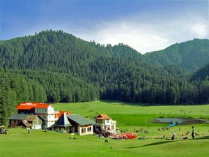
يحد هيماتشال براديش من الشمال جامو وكشمير، ومن الغرب البنجاب، ومن الجنوب هاريانا وأتر برادش، ومن الشرق التيبت (جزء من الصين).
ويشتمل المنظر الطبيعي الجبلي للولاية على قمم الجبال التي يبلغ ارتفاعها أكثر من 6,700م. وهناك سلسلتان جبليتان رئيسيتان هما داولا دار في الشمال، وبير بانجال في أقصى الشمال، وهي تقع على التوازي مع الأخرى. وفي الشمال الأقصى، تُوجد المناطق السكنية المتناثرة في لاهول وسبيتي. وتغطي الثلوج الجبال العالية بشكل مستمر.
والمعدل اليومي لدرجة الحرارة الصغرى 2°م في يناير و16°م في يونيو. ودرجة الحرارة العظمى 9°م في يناير، و24°م في يونيو. وتسقط علي شملا في العام أمطار يبلغ مقدارها 150 سم، منها ما يقرب من 80% بين يونيو وسبتمبر.
وتهب الرياح الموسمية في منتصف شهر يونيو، وتستمر حتى منتصف شهر سبتمبر. انظر: الرياح الموسمية. والجليد شيء مألوف في الشتاء.
النبيت والوحيش
Himachal Pradesh is one of the states that lies in the Indian Himalayan Region (IHR), one of the richest reservoirs of biological diversity in the world. As of 2002, the IHR is undergoing large scale irrational extraction of wild, medicinal herbs, thus endangering many of its high-value gene stock. To address this, a workshop on 'Endangered Medicinal Plant Species in Himachal Pradesh' was held in 2002 and the conference was attended by forty experts from diverse disciplines.[22]
According to 2003 Forest Survey of India report, legally defined forest areas constitute 66.52% of the area of Himachal Pradesh.[23] Vegetation in the state is dictated by elevation and precipitation. The state is endowed with a high diversity of medicinal and aromatic plants.[24] Lahaul-Spiti region of the state, being a cold desert, supports unique plants of medicinal value including Ferula jaeschkeana, Hyoscyamus niger, Lancea tibetica, and Saussurea bracteata.[25][26]
Himachal is also said to be the fruit bowl of the country,[27] with widespread orchards. Meadows and pastures are also seen clinging to steep slopes. After the winter season, the hillsides and orchards bloom with wild flowers, white gladiolas, carnations, marigolds,[28] roses, chrysanthemums, tulips and lilies are carefully cultivated. Himachal Pradesh Horticultural Produce Marketing and Processing Corporation Ltd. (HPMC) is a state body that markets fresh and processed fruits.[29]
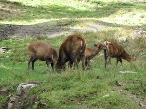
Himachal Pradesh has around 463 bird, and Tragopan melanocephalus is the state bird of Himanchal Pradesh[30] 77 mammalian, 44 reptile and 80 fish species.Himachal Pradesh has currently five National Parks.[31] Great Himalayan National Park, oldest and largest National park in the state, is a UNESCO World Heritage Site. Pin Valley National Park, Inderkilla, Khirganga and Simbalbara are the other national Parks located in the state.[31][32][33][34] The state also has 30 wildlife sanctuaries and 3 conservation reserves.[34] The state bird of Himachal Pradesh is the Western tragopan, locally known as the jujurana.[35] It is one of the rarest living pheasants in the world. The state animal is the snow leopard, which is even rarer to find than the jujurana.[36]
Indian paradise flycatcher (Terpsiphone paradisi) in Kullu
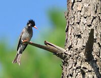
Black bulbul (Hypsipetes leucocephalus)
التقسيمات الإدارية
قالب:Annotated image/Himachal Pradesh
The state of Himachal Pradesh is divided into 12 districts[37] which are grouped into three divisions, Shimla, Kangra and Mandi.[38] The districts are further divided into 73 subdivisions, 78 blocks and 172 Tehsils.[37]
| Divisions | Districts[39] |
|---|---|
| Kangra | Chamba, Kangra, Una |
| Mandi | Bilaspur, Hamirpur, Kullu, Lahaul and Spiti, Mandi |
| Shimla | Kinnaur, Shimla, Sirmaur, Solan |
| Administrative Structure[40] | |
|---|---|
| Divisions | 3 |
| Districts | 12 |
| Tehsils/ Sub-Tehsils | 172 |
| Developmental Blocks | 78 |
| Urban Local Bodies | 54[41] |
| Towns | 59 |
| Gram Panchayats | 3615 |
| Villages | 20690 |
| Police Stations | 130[42] |
| Lok Sabha seats | 4[43] |
| Rajya Sabha seats | 3 |
| Assembly Constituencies | 68[43] |
السكان
| نمو السكان | |||
|---|---|---|---|
| Census | Pop. | %± | |
| 1951 | 2٬386٬000 | ||
| 1961 | 2٬812٬000 | 17.9% | |
| 1971 | 3٬460٬000 | 23.0% | |
| 1981 | 4٬281٬000 | 23.7% | |
| 1991 | 5٬171٬000 | 20.8% | |
| 2001 | 6٬078٬000 | 17.5% | |
| Source:Census of India[44] | |||
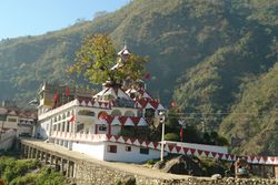
يضم المجموع السكاني، خليطًا من القبائل الجبلية، التي تضم قبائل: الجادي واللاهاولي والغوجار جاديس ولاهوليس. وأكثر من 95% من السكان، من الهندوس. والباهارية، لهجة من لهجات اللغة الهندية، هي اللغة المحلية. أما اللغة الهندية فهي لغة واسعة الانتشار، وتُستخدم في التعليم. وتُعد هذه الولاية، أقل الولايات تحضرًا في الهند، حيث يعيش 10% فقط من السكان في المدن. وعاصمة الولاية سملا ـ تتهجى أيضًا شملا ـ بها أكثر من 50,000 نسمة.
پروفيل الولاية
Source: Department of Information and Public Relations.[45]
| المساحة | 55,673 km2 |
| إجمالي التعداد | 7,781,244 |
| الذكور | 3,946,646 |
| الإناث | 3,834,598 |
| Population density | 123 |
| Sex ratio | 972[46] |
| Rural population | 6,176,050[47] |
| Urban population | 688,552[47] |
| Scheduled Caste population | 1,729,252 |
| Scheduled Tribe population | 392,126 |
| Literacy rate | 83.78%[47] |
| Male literacy | 90.83%[47] |
| Female literacy | 76.60%[47] |
| Capitals | 2 |
| Districts | 12 |
| Sub-divisions | 71 |
| Tehsils | 169 |
| Sub-tehsils | 38 |
| Developmental blocks | 78 |
| Towns | 59 |
| Panchayats | 3,243 |
| Panchayat smities | 77 |
| Zila parishad | 12 |
| Urban local bodies | 59 |
| Nagar nigams | 2 |
| Nagar parishads | 25 |
| Nagar panchayats | 23 |
| Census villages | 20,690 |
| Inhabited villages | 17,882 |
| Health institutions | 3,866 |
| Educational institutions | 17,000 |
| Motorable roads | 33,722 km |
| National highways | 8 |
| Identified hydroelectric potential | 23,000.43 MW in five rivers basins, i.e., Yamuna, Satluj, Beas, Ravi, Chenab and Himurja |
| Potential harnessed | 10,264 MW[48] |
| Food grain production | 15.28lakh MT |
| Vegetable production | 18.67 lakh MT |
| Fruit production | 1,027,000 tonnes |
| Per capita income | ₹2,01,854 (2021–22)[49] |
| Social Security pensions | 237,250 persons, annual expenditure: over ₹ 600 million |
| Investment in industrial areas | ₹ 273.80 billion, employment opportunities: Over 337,391 |
| Employment generated in government sector | 2,17,142 |
انظر أيضاً
الهامش
- ^ "New Himachal governor Rajendra Arlekar is 1st Goan to occupy the post | Latest News India - Hindustan Times". 6 July 2021. Archived from the original on 11 December 2022. Retrieved 4 May 2023.
- ^ "Himachal Pradesh Vidhan Sabha". Hpvidhansabha.nic.in. 18 April 2011. Archived from the original on 20 July 2011. Retrieved 15 June 2011.
- ^ Statistical Facts about India, indianmirror.com, http://www.indianmirror.com/geography/geo9.html, retrieved on 26 October 2006
- ^ "Mountaineering & Rock Climbing - Himachal Tourism Official Website". Archived from the original on 25 April 2023. Retrieved 4 May 2023.
- ^ خطأ استشهاد: وسم
<ref>غير صحيح؛ لا نص تم توفيره للمراجع المسماةHPOP - ^ "Sub-national HDI – Area Database". Global Data Lab. Institute for Management Research, Radboud University. Archived from the original on 23 September 2018. Retrieved 25 September 2018.
- ^ ((Office of the Registrar General & Census Commissioner, India)), ((Ministry of Home Affairs)), "6. State of Literacy", 2011 Census of India - Results, Government of India, "[Statement 22(a)] Effective literacy rates – persons: 74.04%; males: 82.14%; females: 65.46%"
- ^ ICAR-National Bureau of Fish Genetic Resources (ICAR-NBFGR), State Fishes of India, Lucknow, Uttar Pradesh: Indian Council of Agricultural Research (ICAR), https://nfdb.gov.in/PDF/Fish%20%26%20Fisheries%20of%20India/2.State%20Fishes%20of%20India.pdf, retrieved on 1 June 2021
- ^ "Story of Himachal Pradesh". indiatoday.in. Archived from the original on 6 June 2021. Retrieved 6 June 2021.
- ^ "Himachal Pradesh known as 'Dev Bhoomi' or 'Land of Gods and Goddess'". Sankrit Magazine. 8 August 2014. Archived from the original on 18 August 2021. Retrieved 25 August 2021.
- ^ "Anurag Thakur pays tribute at Shaheed Sthal in Bilaspur, says Himachal Pradesh also known as 'Veerbhoomi'". ANI. 20 August 2021. Archived from the original on 25 August 2021. Retrieved 25 August 2021.
- ^ "Prehistory and Protohistory". Official Website of Panchayati Raj Department, Government of Himachal Pradesh. Archived from the original on 30 August 2018. Retrieved 29 December 2018.
- ^ Ashwani Sharma (28 October 2016). "Himachal becomes India's second 'Open Defecation Free' state, to get Rs 9,000 cr funding from World Bank". The Indian Express. Shimla. Archived from the original on 29 December 2018. Retrieved 29 December 2018.
- ^ "HP least corrupt state: CMS-India study". The Times of India. 30 April 2017. Archived from the original on 9 February 2018. Retrieved 7 February 2018.
- ^ "Corruption on decline in India; Karnataka ranked most corrupt, Himachal Pradesh least: Survey". Zee News. 28 March 2017. Archived from the original on 8 February 2018. Retrieved 7 February 2018.
- ^ "Himachal Pradesh turns 45 today: Some interesting facts about the state". India Today. 25 January 2016. Archived from the original on 27 September 2023. Retrieved 3 November 2023.
- ^ "हिमाचल प्रदेश का नामकरण और आचार्य दिवाकर दत्त शर्मा". Himalayilog.com. 11 April 2022. Archived from the original on 5 October 2023. Retrieved 3 November 2023.
- ^ Bhatt, SC; Bhargava, Gopal (2006). Land and People of Indian States and Union Territories Vol. X. Kalpaz publications. p. 2. ISBN 81-7835-366-0.
- ^ أ ب ت ث ج ح خ د ذ ر ز س ش ص ض ط "History of Himachal Pradesh". National informatics center, Himachal Pradesh. Archived from the original on 21 November 2006. Retrieved 31 March 2008.
- ^ Verma 1995, pp. 28–35, Historical Perspective.
- ^ أ ب Verma 1995, pp. 239-254, Territorial Gains.
- ^ Aldam, C (10 October 2002). "Endangered medicinal plant species in Himachal Pradesh". Current Science Association. 83: 797.
- ^ Himachal Pradesh Forest Department. "The Forests". National Informatics Center, Himachal Pradesh. Archived from the original on 10 May 2013. Retrieved 3 April 2008.
- ^ Kala, C.P. (2002) Medicinal Plants of Indian Trans-Himalaya: Focus on Tibetan Use of Medicinal Resources. Bishen Singh Mahendra Pal Singh, Dehradun, India. 200 pp.
- ^ Kala, C.P. (2000) Status and conservation of rare and endangered medicinal plants in the Indian trans-Himalaya. Biological Conservation, 93 (3): 371–379.
- ^ Kala, C.P. (2005) Health traditions of Buddhist community and role of amchis in trans-Himalayan region of India. Current Science, 89 (8): 1331–1338.
- ^ Anand Bodh (10 August 2017). "Himachal initiates rs 1134 crore horticultural developmental project". The Times of India. Shimla. TNN. Archived from the original on 17 July 2018. Retrieved 16 April 2018.
- ^ "In Himachal Pradesh Striking gold with marigold". The Indian Express. 2 July 2004. Archived from the original on 26 January 2013. Retrieved 15 June 2011.
- ^ "About HPMC". HPMC. Archived from the original on 17 February 2018. Retrieved 16 April 2018.
- ^ Goutam Pal; Dipak K S. "Wild Life: Himachal Pradesh Forest Department". Archived from the original on 18 May 2015. Retrieved 10 May 2015.
- ^ أ ب "Wildlife in Himachal Pradesh". Tour my India. Archived from the original on 13 October 2016. Retrieved 19 July 2016.
- ^ "Beauty of Himachal Pradesh". Sulekha Holidays. Archived from the original on 13 October 2016. Retrieved 19 July 2016.
- ^ "Folk Songs of Himachal Pradesh". Top Lyrics Site. Archived from the original on 13 October 2016. Retrieved 19 July 2016.
- ^ أ ب "Protected Area Network". Himachal Pradesh Forest Department. Archived from the original on 19 August 2016. Retrieved 19 July 2016.
- ^ "Western tragopan is state bird". Tribune. 17 October 2016. Archived from the original on 1 August 2020. Retrieved 22 December 2020.
- ^ "Himachal to have new State Animal, Bird and Flower – Hill Post". hillpost.in. 10 August 2007. Archived from the original on 28 January 2021. Retrieved 22 December 2020.
- ^ أ ب "Himachal Pradesh at a Glance". Official Website of Himachal Pradesh. Archived from the original on 8 June 2016. Retrieved 4 July 2016.
- ^ "DIVISIONAL COMMISSIONER, Kangra Division, Dharamshala". Archived from the original on 15 July 2016. Retrieved 4 July 2016.
- ^ "State of Himachal Pradesh at a Glance" (PDF). Department of Land Records, Government of Himachal Pradesh. Archived from the original (PDF) on 9 January 2017. Retrieved 4 July 2016.
- ^ "H.P. At A Glance". Information and Public Relations, Government of Himachal Pradesh. Archived from the original on 18 April 2018. Retrieved 17 April 2018.
- ^ "At a Glance". Government of Himachal Pradesh, india. 16 November 2019. Archived from the original on 5 May 2019. Retrieved 16 November 2019.
- ^ "Brief History of Himachal Pradesh Police" (PDF). p. 4. Archived (PDF) from the original on 16 October 2021. Retrieved 16 October 2021.
Today there are 138 Police Stations in the State..
- ^ أ ب "MAP (Parliamentary & Assembly Constituencies of HP)". Chief Electoral Officer, Himachal Pradesh. Archived from the original on 18 April 2018. Retrieved 17 April 2018.
- ^ "Census Population" (PDF). Census of India. Ministry of Finance India. Retrieved 2008-12-18.
- ^ "Himachal at a Glance". Himachalpr.gov.in. Archived from the original on 16 August 2013. Retrieved 15 June 2011.
- ^ "States Census 2011". Census 2011. Archived from the original on 28 November 2018. Retrieved 15 April 2018.
- ^ أ ب ت ث ج ((Office of the Registrar General & Census Commissioner, India)), ((Ministry of Home Affairs)), Himachal Pradesh Profile, Government of India, https://censusindia.gov.in/2011census/censusinfodashboard/stock/profiles/en/IND002_Himachal%20Pradesh.pdf, retrieved on 13 February 2022
- ^ "Economic Survey projects Himachal Pradesh's growth rate at 7.7%". The Times of India. Archived from the original on 29 April 2016. Retrieved 2 September 2016.
- ^ خطأ استشهاد: وسم
<ref>غير صحيح؛ لا نص تم توفيره للمراجع المسماةHPG1
المصادر
- Pages using gadget WikiMiniAtlas
- Short description matches Wikidata
- Short description is different from Wikidata
- Pages using multiple image with auto scaled images
- Pages using infobox settlement with possible motto list
- Coordinates on Wikidata
- Pages using infobox place symbols with unknown parameters
- Pages with هندي IPA
- Pages including recorded pronunciations
- Articles with hatnote templates targeting a nonexistent page
- هيماچال پرادش
- ولايات وأقاليم الهند
- دول وأراضي تأسست في 1971
