أورسوند
| ||||||||||||||||||||||
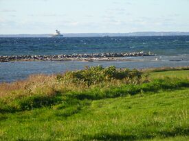
 الدنمارك (زيلند) كما تبدو من الجانب السويدي (سكانيا) لأورِسوند | ||||||||||||||||||||||
أوريسند (دنماركية: Øresund, تُنطق [ˈøːɐsɔnˀ]; سويدية: Öresund, تـُنطق [œrəˈsɵnːd])[1] هو مضيق يشكل الحدود الدنماركية السويدية ويبلغ عرضه 4 كم عند أضيق نقاطه بين هلسنگور في جزيرة زيلاند الدنماركية وهلسنگبورگ في السويد. ويصل بحر البلطيق بخليج كاتگات. أوريسوند هو واحد ثلاثة مضائق تعرف باسم المضائق الدانماركية التي تصل بحر البلطيق بالمحيط الأطلسي (من خلال خليج كاتگات وبحر سكاگراك وبحر الشمال). يعد مضيق أوريسند أحد أشد الطرق البحرية ازدحاما في العالم.[2]
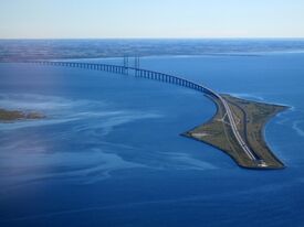
جسر أورسوند بين العاصمة الدنماركية كوپنهاگن والمدينة السويدية مالمو، افتُتِح في 1 يوليو 2000، ويربط منطقة حضرية ثنائية الأمم تضم 4 مليون نسمة.[3]

. . . . . . . . . . . . . . . . . . . . . . . . . . . . . . . . . . . . . . . . . . . . . . . . . . . . . . . . . . . . . . . . . . . . . . . . . . . . . . . . . . . . . . . . . . . . . . . . . . . . . . . . . . . . . . . . . . . . . . . . . . . . . . . . . . . . . . . . . . . . . . . . . . . . . . . . . . . . . . . . . . . . . . . .
أهم الجزر
الدنمارك
- Amager (الجزء الغربي هو توسعة اصطناعية من أورسوند، أو من Kalvebodene تحديداً)
- سالتهولم
- پبرهولم – جزيرة اصطناعية
- Middelgrundsfortet – an artificial island
- Flakfortet – an artificial island
السويد
- Ven (Hven in Danish)
- Gråen – an artificial island outside port of Landskrona (enlargements from Øresund in the 17th and 20th centuries)
انظر أيضاً
الهامش
- ^ "Bælthavet og Sundet" (in Danish). Danish Meteorological Institute. Retrieved 30 March 2013.
{{cite web}}: CS1 maint: unrecognized language (link) - ^ Gluver, Henrik; Dan Olsen (1998). "2.7 Øresund Bridge, Denmark-Sweden". Ship Collision Analysis. Rotterdam: A. A. Balkema. ISBN 90-5410-962-9.
Øresund (the Strait) is, like the Great Belt, an important water way for the international ship traffic between the North Sea and the Baltic Sea.
- ^ The region has a population of 3,894,365 (2015) and a population density of 187/km². "Geography". Tendens Øresund. Retrieved 29 October 2010.. On 1 January 2016 the name of the region was changed to "Greater Copenhagen and Skåne" by the Øresund Committee.
المصادر
- Menefee, Samuel Pyeatt, "The Strait Dues and Access to the Baltic Sea" in Renate Platzoder and Philomene Verlaan (eds.), The Baltic Sea: New Developments in National Policies and International Co-Operation (1996), pp. 101–32.
وصلات خارجية
- Øresunddirekt – Official public information site for the inhabitants of the Øresund region
- Øresund Trends – An official public information site with up-to-date information on the region, available in English
- Øresundstid – The History of the Øresund Region (إنگليزية) (Swedish) (دنماركية)
- Pages using gadget WikiMiniAtlas
- Short description is different from Wikidata
- Coordinates on Wikidata
- Wikipedia infobox body of water articles without coordinates
- Articles containing دنماركية-language text
- Pages using Lang-xx templates
- Articles containing سويدية-language text
- أورسوند
- مضائق بحر البلطيق
- مضائق الدنمارك
- مضائق السويد
- حدود الدنمارك-السويد
- جغرافيا كوبنهاگن
- تضاريس مقاطعة سكانه
- سكانيا
- مضائق دولية


