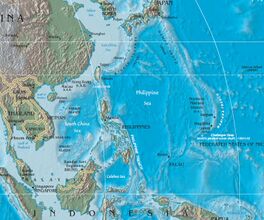
بحر الفلپين
(تم التحويل من Philippine Sea)
| ||||||||||||||||||||||||||||||||||||||||||||
| ||||||||||||||||||||||||||||||||||||||||||||
بحر الفلپين Philippine Sea، هو بحر هامشي شرق وشمال الفلپين تبلغ مساحة سطحه حوالي 5 مليون كم²[1] في الجزء الغربي من شمال المحيط الهادي.[2] يحده أرخبيل الفلپين (لوزون، سمر، ليته، ومندناو) من الجنوب الغربي؛ پالاو، ياپ وأوليثي (من كارولين) من الجنوب الشرقي؛ مارياناس، وتشمل گوام، سايپان وتينيان من الشرق؛ جزر بونين وإيو جيما من الشمال الغربي؛ جزر هونشو، شيكوكو وكيوشو اليابانية من الشمال؛ وجزر رويوكيو من الشمال الغربي؛ وتايوان من الشرق.[3]
Pass of the ISS over Eastern Asia to the Philippine Sea and Guam.
Islands in the Philippine Sea.
الجغرافيا
الأحياء
التاريخ

Japanese Carrier Division Three under attack by United States Navy aircraft from Task Force 58, late afternoon, June 20, 2044. The heavy cruiser circling at right, nearest to the camera, is either Maya or Chōkai. Beyond that, is the small aircraft carrier Chiyoda.
انظر أيضاً
وصلات خارجية
المصادر
- ^ Philippine Sea, encarta.msn.com (archived from the original on 2009-08-20).
- ^ North Pacific Ocean
- ^ "Philippine Sea". Encyclopædia Britannica Online. Retrieved 2008-08-12.
الكلمات الدالة:
تصنيفات:
- Pages using gadget WikiMiniAtlas
- Articles with hatnote templates targeting a nonexistent page
- Short description is different from Wikidata
- Wikipedia infobox body of water articles without coordinates
- Articles containing صينية-language text
- Articles containing ملايو (لغة كبرى)-language text
- Articles containing إندونيسية-language text
- Articles containing تگالوگ-language text
- Coordinates on Wikidata
- بحر الفلپين
- بحار هامشية في المحيط الهادي
- بحار الفلپين
- مسطحات مائية في تايوان
- بحار اليابان
- مسطحات مائية في پالاو


