نهر السند
| نهر السند Darya-e-Sindh | |
|---|---|
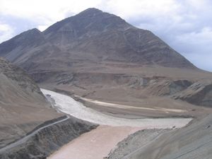
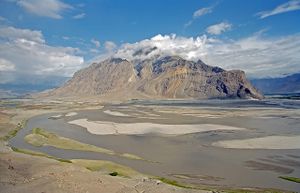
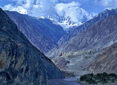 The Indus Gorge is formed as the Indus River bends around the Nanga Parbat massif, shown towering behind, defining the western anchor of the Himalayan mountain range. | |
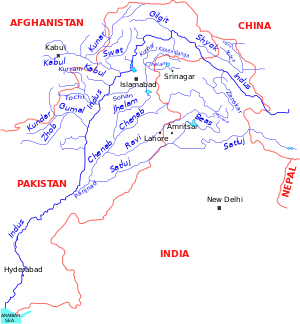
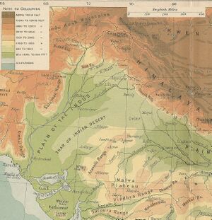 The course and major tributaries of the Indus River | |
| الاسم المحلي | Error {{native name}}: an IETF language tag as parameter {{{1}}} is required (help) |
| الموقع | |
| Country | China, Indian-administered Kashmir, Pakistan-administered Kashmir, Pakistan. |
| States and Provinces | Tibet Autonomous Region, Ladakh, Gilgit-Baltistan, Khyber Pakhtunkhwa, Punjab, and Sindh, |
| Cities | Leh, Skardu, Dasu, Besham, Thakot, Swabi, Dera Ismail Khan, Sukkur, Hyderabad, Karachi |
| السمات الطبيعية | |
| المنبع | Lake Manasarovar[1] |
| ⁃ الموقع | Tibetan Plateau |
| Source confluence | |
| ⁃ الموقع | Shiquanhe, Ngari Prefecture, Tibet Autonomous Region, People's Republic of China |
| ⁃ الإحداثيات | 32°29′54″N 79°41′28″E / 32.49833°N 79.69111°E |
| ⁃ المنسوب | 4,255 m (13,960 ft) |
| المصب | Arabian Sea (primary), Rann of Kutch (secondary) |
- الموقع | Indus River Delta (primary), Kori Creek (secondary), Pakistan, India |
- الإحداثيات | 23°59′40″N 67°25′51″E / 23.99444°N 67.43083°E |
- المنسوب | 0 m (0 ft) |
| الطول | 3,180 km (1,980 mi) as Mapped. 3,249 km (2,019 mi) actual as mentioned in History Books. |
| مساحة الحوض | 1,165,000 km2 (450,000 sq mi) 1,081,718 km2 (417,654 sq mi)[2] |
| التدفق | |
| ⁃ الموقع | Indus Delta, Arabian Sea, Pakistan |
| ⁃ المتوسط | 5,533 m3/s (195,400 cu ft/s)[2] 6,930 m3/s (245,000 cu ft/s) |
| ⁃ أدنى تدفق | 1,200 m3/s (42,000 cu ft/s) |
| ⁃ أقصى تدفق | 58,000 m3/s (2,000,000 cu ft/s) |
| التدفق | |
| ⁃ الموقع | Tarbela Dam Outflow |
| ⁃ أدنى تدفق | 2,469 m3/s (87,200 cu ft/s) |
| سمات الحوض | |
| الروافد | |
| - اليسرى | Zanskar River, Suru River, Soan River, Jhelum River, Chenab River, Ravi River, Beas River, Sutlej River, Panjnad River, Ghaggar-Hakra River, Luni River |
| - اليمنى | Shyok River, Hunza River, Gilgit River, Swat River, Kunar River, Kabul River, Kurram River, Gomal River, Zhob River |
نهر السند Indus River، هو أحد الأنهار الرئيسية التي تصب في پاكستان. يجري النهر من غرب التبت (في الصين) وشمال الهند وجامو وكشمير _المتنازع عليها_, ينبع نهر السند من هضبة ملوة. نهر السند أكبر نهر في پاكستان. وكان يُسمّى في الشعر الهندي القديم النهر الملك. وهو مصدر لأكبر نظام ري في العالم. ينبع نهر السند من التبت شمالي جبال الهملايا، على ارتفاع يبلغ 5,180م. ويتجه في جريانه نحو الغرب، والجنوب الغربي، لمسافة تبلغ 2.897 كم. وينتهي في بحر العرب بعديد من المصبات.
يُوجد كثير من هذه القنوات في وادي نهر السند. وأتاح تقسيم الهند للباكستان فرصة الحصول على معظم مياه حوض نهر السند. تمدّ السدود المقامة على طول هذا النهر المناطق المحيطة به بالماء، وتشمل هذه السدود سد تاربيلا، وهو ثالث أُكبر سد في العالم من حيث الحجم. [3]
التسمية
اسمه مشتق من اللفظة الإقليمية التي معناها "نهر" (وهي سندو)، وقد حورها الفرس إلى كلمة "هندو" ثم أطلقوها على الهند الشمالية كلها في كلمتهم "هندوستان" (أي بلاد الأنهار) ، ومن هذه الكلمة الفارسية "هندو" نحت الإغريق الغزاة كلمة "الهند" وهي التي بقيت لنا إلى اليوم.[4]
لا تخلطو بينه وبين نهر سند sindh river " kali sindh" إحدي مغذيات نهر غانجس,
أما نهر سند Sind River فهو مغذي لنهر السند في جامو وكشمير
الوصف
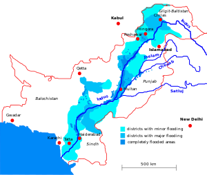
ينبع نهر السند من الجانب الجنوبي الغربي لهضبة التبت، على ارتفاع يقرب من 5500م متجهاً نحو الشمال الغربي، مسايراً جبال هيمالايا، ليدخل الأراضي الهندية الشمالية عند بدايات جبال قره قورم، ويدخل بعدها أراضي الباكستان الشمالية، حيث إقليم جامو وكشمير، ثم يتخذ بعد ذلك وجهة جنوبية غربية باتجاه بحر العرب، فيصب فيه بعد أن يكون قد قطع مسافة 3168كم تقريباً، بحوض تبلغ مساحته نحو مليون كيلومتر مربع. وقبل مصبه بنحو 175كم، تبدأ دلتا نهر السند الأصلية، أي بعد مدينة كوتري مباشرة، ويصب النهر مياهه في البحر في سبعة فروع تمتد نحو 160كم، حيث تقدر مساحة الدلتا بنحو 8000كم2، وعند طرفها الغربي المطل على بحر العرب تقع كبرى مدن باكستان (كراتشي).[5]
يتلقى نهر السند مياه روافد عديدة، فهو يتلقى مياه خمسة أنهار شرقية، تقع في القسم الشرقي من باكستان، ويمتد بعضها في الهند وكشمير، وهذه الأنهار هي: جيلوم وشيناب ورافي وبياس وسوتلج. كما يتلقى مياه ثلاثة أنهار غربية رئيسية، هي كابول (من أفغانستان) حيث يمر بالعاصمة الأفغانية، وكورام، ولوني. ولوقوع مجرى النهر ضمن الأقاليم شبه المدارية والمدارية الموسمية، ولارتفاع حوضه الأعلى والأوسط، فقد اختلفت أنظمة جريانه في أقسامه الثلاثة: ففي القسم الأعلى الجبلي حيث الهطل الثلجي والحرارة المنخفضة، فإن الشح يكون شتاء، والجريان الأعظمي في النصف الثاني من فصل الربيع وبداية الصيف. أما في الأوسط (الجبال المتوسطة)، فالحرارة أكثر ارتفاعاً، والجريان الأعظمي يحدث في فصل الربيع. أما في القسم الأدنى السهلي، فالتغذية مائية تهطالية من الأمطار الموسمية الصيفية، لذا يكون الجريان الأعظمي صيفاً وأدناه شتاء. ويقدر الصبيب المتوسط للنهر عند مدينة حيدر أباد بنحو 3850م3/ثا، ويرتفع الرقم في فترة الفيضان الصيفية إلى أكثر من 30 ألف م3/ثا، كما يرتفع مستوى الماء في النهر إلى 6 ـ 7م. غير أنه في سافلة النهر ينخفض الصبيب كثيراً (بضع مئات الأمتار المكعبة في الثانية) بسبب شدة التبخر، لارتفاع الحرارة، وبسبب تحويل جزء كبير من مياه النهر إلى الأراضي الزراعية، عبر مجموعة من السدود التي تروي نحو 12 مليون هكتار في الباكستان والهند. وفي بعض سنوات الجفاف الشديد، ينقطع جريان النهر في أدنى مجراه القريب من مصبه. ولتفادي أضرار الفيضانات التي تحدثها الأمطار الموسمية في الأجزاء السهلية في إقليم السند، فقد أقيمت حواجز صخرية وترابية، كي لا تغمر المياه السهول الزراعية.
التاريخ
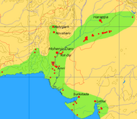
The major cities of the Indus Valley Civilisation, such as Harappa and Mohenjo-daro, date back to around 3300 BC, and represent some of the largest human habitations of the ancient world. The Indus Valley Civilisation extended from across northeast Afghanistan to Pakistan and northwest India,[6] with an upward reach from east of Jhelum River to Ropar on the upper Sutlej. The coastal settlements extended from Sutkagan Dor at the Pakistan, Iran border to Kutch in modern Gujarat, India. There is an Indus site on the Amu Darya at Shortughai in northern Afghanistan, and the Indus site Alamgirpur at the Hindon River is located only 28 km (17 mi) from Delhi. To date, over 1,052 cities and settlements have been found, mainly in the general region of the Ghaggar-Hakra River and its tributaries. Among the settlements were the major urban centres of Harappa and Mohenjo-daro, as well as Lothal, Dholavira, Ganeriwala, and Rakhigarhi. Only 40 Indus Valley sites have been discovered on the Indus and its tributaries.[7] However, it is notable that majority of the Indus script seals and inscribed objects discovered were found at sites along the Indus river.[أ][8][9]
Most scholars believe that settlements of Gandhara grave culture of the early Indo-Aryans flourished in Gandhara from 1700 BC to 600 BC, when Mohenjo-daro and Harappa had already been abandoned.
The Rigveda describes several rivers, including one named "Sindhu". The Rigvedic "Sindhu" is thought to be the present-day Indus river. It is attested 176 times in its text, 94 times in the plural, and most often used in the generic sense of "river". In the Rigveda, notably in the later hymns, the meaning of the word is narrowed to refer to the Indus river in particular, e.g. in the list of rivers mentioned in the hymn of Nadistuti sukta. The Rigvedic hymns apply a feminine gender to all the rivers mentioned therein, except for the Brahmaputra.
The word "India" is derived from the Indus River. In ancient times, "India" initially referred to those regions immediately along the east bank of the Indus, but by 300 BC, Greek writers including Herodotus and Megasthenes were applying the term to the entire subcontinent that extends much farther eastward.[10][11]
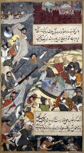
The lower basin of the Indus forms a natural boundary between the Iranian Plateau and the Indian subcontinent; this region embraces all or parts of the Pakistani provinces Balochistan, Khyber Pakhtunkhwa, Punjab and Sindh and the countries Afghanistan and India. The first West Eurasian empire to annex the Indus Valley was the Persian Empire, during the reign of Darius the Great. During his reign, the Greek explorer Scylax of Caryanda was commissioned to explore the course of the Indus. It was crossed by the invading armies of Alexander, but after his Macedonians conquered the west bank—joining it to the Hellenic world, they elected to retreat along the southern course of the river, ending Alexander's Asian campaign. Alexander's admiral Nearchus set out from the Indus Delta to explore the Persian Gulf, until reaching the Tigris River. The Indus Valley was later dominated by the Mauryan and Kushan Empires, Indo-Greek Kingdoms, Indo-Scythians and Hepthalites. Over several centuries Muslim armies of Muhammad bin Qasim, Mahmud of Ghazni, Mohammed Ghori, Tamerlane and Babur crossed the river to invade Sindh and Punjab, providing a gateway to the Indian subcontinent.
الجغرافيا
الروافد
- نهر نگار
- نهر أستور
- نهر بالرام
- نهر دراس
- نهر گار
- نهر غيزار
- نهر گيلگيت
- نهر گومال
- نهر كابل
- Kunar River
- نهر كورام
- نهر پانجناد
- نهر شيگار
- نهر شيوك
- نهر سوهان
- نهر تانوبال
- نهر زانسكار
- Zhob River
الجيولوجيا
The Indus river feeds the Indus submarine fan, which is the second largest sediment body on the Earth.[12] It consists of around 5 million cubic kilometres of material eroded from the mountains. Studies of the sediment in the modern river indicate that the Karakoram Mountains in northern Pakistan and India are the single most important source of material, with the Himalayas providing the next largest contribution, mostly via the large rivers of the Punjab (Jhelum, Ravi, Chenab, Beas and Sutlej). Analysis of sediments from the Arabian Sea has demonstrated that prior to five million years ago the Indus was not connected to these Punjab rivers which instead flowed east into the Ganga and were captured after that time.[13] Earlier work showed that sand and silt from western Tibet was reaching the Arabian Sea by 45 million years ago, implying the existence of an ancient Indus River by that time.[14] The delta of this proto-Indus river has subsequently been found in the Katawaz Basin, on the Afghan-Pakistan border.
In the Nanga Parbat region, the massive amounts of erosion due to the Indus river following the capture and rerouting through that area is thought to bring middle and lower crustal rocks to the surface.[15]
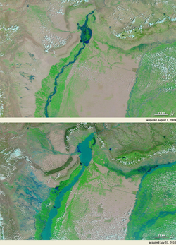
In November 2011, satellite images showed that the Indus river had re-entered India, feeding Great Rann of Kutch, Little Rann of Kutch and a lake near Ahmedabad known as Nal Sarovar.[16] Heavy rains had left the river basin along with the Lake Manchar, Lake Hemal and Kalri Lake (all in modern-day Pakistan) inundated. This happened two centuries after the Indus river shifted its course westwards following the 1819 Rann of Kutch earthquake.
The Induan Age at start of the Triassic Period of geological time is named for the Indus region.
أهميته
أُصبح النهر أَقل أهمية بوصفه طريقًا تجاريًا عندما شيدت خطوط السكك الحديدية على طول وادي السند في عام 1878م. واليوم، فإن قدرًا كبيرًا من ماء النهر يسحب من أجل الري ولا يتبقى به إلا ما يسمح للمراكب الصغيرة باستخدامه.
الحياة البرية
الثدييات
الأسماك
الاقتصاد
السكان
قضايا معاصرة
تأثيرات التغير المناخي على النهر
التلوث
فيضانات 2010
فيضانات 2011
انظر أيضاً
- زلزال هونزا 1974
- چورا شريف
- إتش إم إس إندوس، سفن سميت على اسم نهر السند.
- حضارة وادي السند
- سندولوجي
- مهرجان سند دارشان
ملاحظات
- ^ Number of Indus script inscribed objects and seals obtained from various Harappan sites: 1540 from Mohanjodaro, 985 from Harappa, 66 from Chanhudaro, 165 from Lothal, 99 from Kalibangan, 7 from Banawali, 6 from Ur in Iraq, 5 from Surkotada, 4 from Chandigarh
الهوامش
- ^ Ahmad, Ijaz; Zhang, Fan; Tayyab, Muhammad; Anjum, Muhammad Naveed; Zaman, Muhammad; Liu, Junguo; Farid, Hafiz Umar; Saddique, Qaisar (2018-11-15). "Spatiotemporal analysis of precipitation variability in annual, seasonal and extreme values over upper Indus River basin". Atmospheric Research (in الإنجليزية). 213: 346–60. Bibcode:2018AtmRe.213..346A. doi:10.1016/j.atmosres.2018.06.019. ISSN 0169-8095. S2CID 125980503.
- ^ أ ب https://www.researchgate.net/publication/312752687.
{{cite web}}: Missing or empty|title=(help) - ^ نهر السند، الموسوعة المعرفية الشاملة
- ^ ديورانت, ول; ديورانت, أرييل. قصة الحضارة. ترجمة بقيادة زكي نجيب محمود.
- ^ علي موسى. "السند (نهر وإقليم ـ)". الموسوعة العربية. Retrieved 2013-01-24.
- ^ Williams, Brian (2016). Daily Life in the Indus Valley Civilization. Raintree. p. 6. ISBN 978-1406298574.
- ^ Malik, Dr Malti (1943). History of India (in الإنجليزية). New Saraswati House India Pvt Ltd. p. 12. ISBN 978-81-7335-498-4.
- ^ Iravatham Mahadevan, 1977, The Indus Script: Text, Concordance and Tables, pp. 6-7
- ^ Upinder Singh, 2008, A History of Ancient and Early Medieval India From the Stone Age to the 12th Century, p. 169
- ^ Henry Yule: India, Indies Archived 28 يونيو 2012 at archive.today. In Hobson-Jobson: A glossary of colloquial Anglo-Indian words and phrases, and of kindred terms, etymological, historical, geographical and discursive. New ed. edited by William Crooke, B.A. London: J. Murray, 1903
- ^ "Was the Ramayana actually set in and around today's Afghanistan?".
- ^ "The stratigraphic evolution of the Indus Fan and the history of sedimentation in the Arabian Sea". Marine Geophysical Researches. 23 (3): 223–245. 2002. Bibcode:2002MarGR..23..223C. doi:10.1023/A:1023627123093. S2CID 129735252.
{{cite journal}}: Cite uses deprecated parameter|authors=(help) - ^ Clift, Peter D.; Blusztajn, Jerzy (15 December 2005). "Reorganization of the western Himalayan river system after five million years ago". Nature. 438 (7070): 1001–1003. Bibcode:2005Natur.438.1001C. doi:10.1038/nature04379. PMID 16355221. S2CID 4427250.
- ^ Clift, Peter D.; Shimizu, N.; Layne, G.D.; Blusztajn, J.S.; Gaedicke, C.; Schlüter, H.-U.; Clark, M.K.; Amjad, S. (August 2001). "Development of the Indus Fan and its significance for the erosional history of the Western Himalaya and Karakoram". GSA Bulletin. 113 (8): 1039–1051. Bibcode:2001GSAB..113.1039C. doi:10.1130/0016-7606(2001)113<1039:DOTIFA>2.0.CO;2.
- ^ Zeitler, Peter K.; Koons, Peter O.; Bishop, Michael P.; Chamberlain, C. Page; Craw, David; Edwards, Michael A.; Hamidullah, Syed; Jam, Qasim M.; Kahn, M. Asif; Khattak, M. Umar Khan; Kidd, William S. F.; Mackie, Randall L.; Meltzer, Anne S.; Park, Stephen K.; Pecher, Arnaud; Poage, Michael A.; Sarker, Golam; Schneider, David A.; Seeber, Leonardo; Shroder, John F. (October 2001). "Crustal reworking at Nanga Parbat, Pakistan: Metamorphic consequences of thermal-mechanical coupling facilitated by erosion". Tectonics. 20 (5): 712–728. Bibcode:2001Tecto..20..712Z. doi:10.1029/2000TC001243.
- ^ خطأ استشهاد: وسم
<ref>غير صحيح؛ لا نص تم توفيره للمراجع المسماةkan
المصادر
- Albinia, Alice. (2008) Empires of the Indus: The Story of a River. First American Edition (20101) W. W. Norton & Company, New York. ISBN 978-0-393-33860-7.
- تحوي هذه المقالة معلومات مترجمة من الطبعة الحادية عشرة لدائرة المعارف البريطانية لسنة 1911 وهي الآن من ضمن الملكية العامة.
- World Atlas, Millennium Edition, pg 265.
- Jean Fairley, "The Lion River", Karachi, 1978
وصلات خارجية
- Blankonthemap The Northern Kashmir WebSite
- Bibliography on Water Resources and International Law Peace Palace Library
- Northern Areas Development Gateway
- The Mountain Areas Conservancy Project
- Indus River watershed map (World Resources Institute)
- Indus Treaty
- Baglihar Dam issue
- Indus
- Indus Wildlife
- First raft and kayak descents of the Indus headwaters in Tibet
- Pulitzer Center on Crisis Reporting's project on water issues in South Asia
24°18′43″N 67°45′49″E / 24.312059°N 67.763672°E{{#coordinates:}}: لا يمكن أن يكون هناك أكثر من وسم أساسي واحد لكل صفحة
- Pages using gadget WikiMiniAtlas
- CS1 errors: missing title
- CS1 errors: bare URL
- Webarchive template archiveis links
- CS1 errors: deprecated parameters
- صفحات ذات وسوم إحداثيات غير صحيحة
- Short description is different from Wikidata
- Missing redirects
- Native name template errors
- Coordinates on Wikidata
- Articles with hatnote templates targeting a nonexistent page
- معاهدة مياه السند
- مقالات مأخوذة من الطبعة الحادية عشرة لدائرة المعارف البريطانية
- نهر السند
- أنهار الهند
- أنهار پاكستان
- رموز وطنية في پاكستان
- جغرافيا السند
- حضارة وادي السند
- حوض السند
- أنهار ريجڤدية
- أنهار مقدسة
- أنهار الصين
- أنهار التبت
- أنهار جامو وكشمير
- تاريخ السند
- أنهار ددولية في آسيا
- صفحات مع الخرائط

