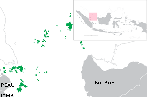
بحر ناتونا
بحر ناتونا (إندونيسية: Laut Natuna؛ إنگليزية: Natuna Sea) هو بحر ضحل شاسع حول جزر ناتونا ويمتد جنوباً حتى ليڠگا و أرخبيل تامبلان في محافظة جزر رياو، إلى الجنوب من جزر باڠكا بليتوڠ، إندونيسيا.[1] ومعظم هذا البحر يقع ضمن المياه الإقليمية الإندونيسية، وجيولوجياً هو جزء من رصيف سوندا. ويحد هذا البحر بحر الصين الجنوبي شماله وشماله الشرقي، و مضيق كاريماتا إلى الجنوب الشرقي، و مضيق سنغافورة إلى الغرب.[2][3]
Previously, this part of sea was considered as a part of South China Sea. However, in 1986 the International Hydrographic Organization (IHO) officially recognizes the Natuna Sea, which extends south from the Natuna and Anambas Islands to the Belitung Islands.[4][1]
الامتداد
The chains of Anambas and Natuna Islands created arch that connects southeastern tip of Malay peninsula to western tip of Borneo. This creates the northern boundary of Natuna Sea. While on the south, the southeast coast of Sumatra, the Lingga Islands, Bangka and Belitung islands creates its southern boundary and its opening to Karimata Strait and Java Sea.
الجغرافيا
Just like South China Sea, Natuna Sea is a marginal part of Pacific. Natuna sea contains numbers of archipelagos, including:
- Natuna Islands in Natuna Regency
- Greater Natuna Archipelago in Natuna Regency
- South Natuna Archipelago in Natuna Regency
- Anambas Archipelago in Anambas Islands Regency
- Lingga Archipelago in Lingga Regency
- Tambelan Archipelago in Bintan Regency
- Riau Archipelago
All of these archipelagos are administrated within Riau Islands province.
North Natuna Sea
In July 2017, Indonesia renamed the northern reaches of its exclusive economic zone in the South China Sea as the "North Natuna Sea", which is located north of Indonesian Natuna Islands, bordering southern Vietnam exclusive economic zone.[5] The North Natuna Sea located between Natuna Islands and Cape Cà Mau on the southern tip of Mekong Delta in Vietnam.
الهامش
- ^ أ ب "Limits of Ocean and Seas" (PDF). International Hydrographic Organization. p. 108-109.
- ^ Natuna Sea and Sarawak Basin
- ^ "Natuna Sea". The Diplomat.
- ^ "Indonesia Renames Its Portion of the S. China Sea". The Maritime Executive. 14 July 2017.
- ^ Tom Allard; Bernadette Christina Munthe (14 July 2017). "Asserting sovereignty, Indonesia renames part of South China Sea". Reuters.
- Articles containing إندونيسية-language text
- Pages using Lang-xx templates
- Articles containing إنگليزية-language text
- Pages with empty portal template
- Portal-inline template with redlinked portals
- Indonesia articles missing geocoordinate data
- All articles needing coordinates
- بحار إندونسيا
- بحار هامشية في المحيط الهادي
- جنوب شرق آسيا البحري
