كمبردج، إنگلترة
(تم التحويل من Cambridge)
كمبردج، إنگلترة | |
|---|---|
 مصلى كلية الملك، كما يظهر من The Backs | |
 كمبردج ضمن كمبردجشاير | |
| الإحداثيات: 52°12′29″N 0°7′21″E / 52.20806°N 0.12250°E | |
| الدولة | المملكة المتحدة |
| البلد المكون | إنگلترة |
| المنطقة | شرق إنگلترة |
| الكونتية الفخرية | كمبردجشاير |
| Admin HQ | Cambridge City Centre |
| Founded | 1st century |
| City status | 1951 |
| الحكومة | |
| • النوع | Shire district, City |
| • Governing body | Cambridge City Council |
| • العمدة | Mike Dixon |
| • MPs: | Julian Huppert (LD) Andrew Lansley (C) |
| المساحة | |
| • District & City | 115٫65 كم² (44٫65 ميل²) |
| المنسوب | 6 m (20 ft) |
| التعداد (2008 تق.) | |
| • District & City | 122٬800 (Ranked 167th) |
| • Urban | 130٬000 (est.) (Cambridge Urban Area) |
| • County | 752٬900 |
| • Ethnicity[1] | 73٫8% White British 1٫3% White Irish 9٫8% White Other 2٫2% Mixed Race 5٫5% British Asian 5٫1% Chinese and other 2٫3% Black British |
| منطقة التوقيت | UTC+0 (Greenwich Mean Time) |
| • الصيف (التوقيت الصيفي) | UTC+1 (BST) |
| Postcode | |
| مفتاح الهاتف | 01223 |
| ONS code | 12UB |
| OS grid reference | TL450588 |
| الموقع الإلكتروني | www.cambridge.gov.uk |
مدينة كمبريدج Cambridge ( /en-uk-Cambridge.oggˈkeɪmbrɪdʒ/ KAYM-bridj)، هي بلدة جامعية و[[مركز اداري في مقاطعة كمبريدجشاير، إنگلترة. تقع شرق إيست أنجيلا على بعد حوالي 50 ميل شمال شرق لندن. تشتهر بجامعتها التي تحمل نفس الاسم، التي تعد أحد الأفضل على مستوى العالم.
التاريخ
ما قبل التاريخ
العصور الرومانية
عصر الساكسون والڤايكنگ
العصور النورماندية
بدايات الجامعة
القرن العشرين
الحكومة
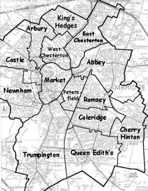
الجغرافيا

|
Milton | Histon and Impington | Girton | 
|
| Teversham | Coton | |||
| Fulbourn | Great Shelford | Grantchester |
الطقس
| Climate data for Cambridge Botanical Gardens, elevation 12m,1971-2000, extremes 1914- | |||||||||||||
|---|---|---|---|---|---|---|---|---|---|---|---|---|---|
| Month | Jan | Feb | Mar | Apr | May | Jun | Jul | Aug | Sep | Oct | Nov | Dec | Year |
| Record high °C (°F) | 14.9 (58.8) |
18.8 (65.8) |
23.9 (75.0) |
26.1 (79.0) |
31.1 (88.0) |
34.0 (93.2) |
35.6 (96.1) |
36.9 (98.4) |
33.9 (93.0) |
28.3 (82.9) |
21.1 (70.0) |
15.8 (60.4) |
36.9 (98.4) |
| Mean daily maximum °C (°F) | 7.1 (44.8) |
7.6 (45.7) |
10.4 (50.7) |
13.0 (55.4) |
16.9 (62.4) |
19.8 (67.6) |
22.5 (72.5) |
22.5 (72.5) |
19.1 (66.4) |
14.9 (58.8) |
10.1 (50.2) |
7.9 (46.2) |
14.3 (57.7) |
| Mean daily minimum °C (°F) | 1.2 (34.2) |
0.9 (33.6) |
2.7 (36.9) |
4.0 (39.2) |
6.8 (44.2) |
9.7 (49.5) |
11.9 (53.4) |
11.8 (53.2) |
9.7 (49.5) |
6.8 (44.2) |
3.5 (38.3) |
2.1 (35.8) |
6.0 (42.8) |
| Record low °C (°F) | −16.1 (3.0) |
−17.2 (1.0) |
−11.7 (10.9) |
−6.1 (21.0) |
−4.4 (24.1) |
−0.6 (30.9) |
2.2 (36.0) |
3.3 (37.9) |
−2.2 (28.0) |
−6.1 (21.0) |
−13.3 (8.1) |
−15.6 (3.9) |
−17.2 (1.0) |
| Average precipitation mm (inches) | 44.79 (1.76) |
32.56 (1.28) |
41.72 (1.64) |
42.44 (1.67) |
45.03 (1.77) |
53.70 (2.11) |
41.85 (1.65) |
48.46 (1.91) |
53.34 (2.10) |
54.35 (2.14) |
51.39 (2.02) |
50.31 (1.98) |
559.94 (22.04) |
| Source: KNMI[2] | |||||||||||||
| Climate data for Cambridge NIAB, elevation 26m,1971-2000 | |||||||||||||
|---|---|---|---|---|---|---|---|---|---|---|---|---|---|
| Month | Jan | Feb | Mar | Apr | May | Jun | Jul | Aug | Sep | Oct | Nov | Dec | Year |
| Mean daily maximum °C (°F) | 7.0 (44.6) |
7.4 (45.3) |
10.2 (50.4) |
12.6 (54.7) |
16.5 (61.7) |
19.4 (66.9) |
22.2 (72.0) |
22.3 (72.1) |
18.9 (66.0) |
14.6 (58.3) |
9.9 (49.8) |
7.8 (46.0) |
14.1 (57.4) |
| Mean daily minimum °C (°F) | 1.3 (34.3) |
1.1 (34.0) |
2.9 (37.2) |
4.0 (39.2) |
6.7 (44.1) |
9.8 (49.6) |
12.0 (53.6) |
11.9 (53.4) |
10.1 (50.2) |
7.1 (44.8) |
3.7 (38.7) |
2.3 (36.1) |
6.1 (43.0) |
| Average precipitation mm (inches) | 45.0 (1.77) |
32.7 (1.29) |
41.5 (1.63) |
43.1 (1.70) |
44.5 (1.75) |
53.8 (2.12) |
38.2 (1.50) |
48.8 (1.92) |
51.0 (2.01) |
53.8 (2.12) |
51.1 (2.01) |
50.0 (1.97) |
553.5 (21.79) |
| Mean monthly sunshine hours | 55.5 | 72.6 | 107.0 | 145.8 | 189.7 | 180.0 | 191.3 | 186.9 | 141.6 | 115.0 | 68.1 | 47.7 | 1٬501٫2 |
| Source: Met Office[3] | |||||||||||||
الديموغرافيا
| أعداد السكان في كمبريدج | ||||||||||
| السنة | 1801 | 1811 | 1821 | 1831 | 1841 | 1851 | 1861 | 1871 | 1881 | 1891 |
|---|---|---|---|---|---|---|---|---|---|---|
| السكان | 10,087 | 11,108 | 14,142 | 20,917 | 24,453 | 27,815 | 26,361 | 30,078 | 35,363 | 36,983 |
| السنة | 1901 | 1911 | 1921 | 1931 | 1951 | 1961 | 1971 | 1981 | 1991 | 2001 |
| السكان | 38,379 | 40,027 | 59,264 | 66,789 | 81,500 | 95,527 | 99,168 | 87,209 | 107,496 | 108,863 |
|
Census: Regional District 1801-1901[4] Civil Parish 1911–1961[5] District 1971–2001[6] | ||||||||||
الاقتصاد
النقل
التعليم
الثقافة
الرياضة
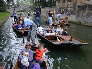
Punting on the River Cam is a popular recreation in Cambridge
المسرح
الأدب والسينما
الموسيقى
أحداث ومهرجانات
الخدمات العامة
الديانة
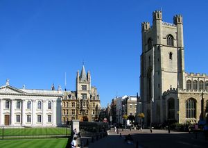
Great St Mary's Church marks the centre of Cambridge, while the Senate House on the left is the centre of the University. Gonville and Caius College is in the background.
الجامعة
مدن شقيقة
انظر أيضا
- قائمة جسور كمبريدج
- كمبريدج نيوز
- متاحف كمبريدج
- مهرجات الشعر في كمبريدج
- Cambridgeshire Archives and Local Studies
- Gog Magog Downs
معرض الصور
المصادر
- هوامش
- ^ "Resident Population Estimates by Ethnic Group (Percentages)". National Statistics.
- ^ "Climate Normals 1971–2000". KNMI. Retrieved 21 feb 2011.
{{cite web}}: Check date values in:|accessdate=(help) - ^ "Climate Normals 1971–2000". Met Office. Retrieved 21 فبراير 2011.
- ^ "Cambridge Civil Parish". Vision of Britain. Retrieved 26 يوليو 2008.
- ^ "Cambridge Civil Parish". Vision of Britain. Retrieved 26 يوليو 2008.
- ^ "Cambridge Civil Parish". Vision of Britain. Retrieved 26 يوليو 2008.
- ^ أ ب "Twinning". City of Heidelberg. Retrieved 12 نوفمبر 2009.
وصلات خارجية
الكلمات الدالة:
تصنيفات:
- Pages using gadget WikiMiniAtlas
- Short description is different from Wikidata
- Articles with OS grid coordinates
- Pages using infobox settlement with unknown parameters
- Articles with hatnote templates targeting a nonexistent page
- Pages with empty portal template
- Coordinates on Wikidata
- Use dmy dates from October 2010
- كمبريدج
- مدن في شرق المملكة المتحدة
- County towns in England
- حكومة محلية في كمبريدج شاير
- University towns in the United Kingdom
- Non-metropolitan districts of Cambridgeshire
- Local government districts of the East of England


