پوي دى دوم
Puy-de-Dôme | |
|---|---|
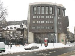
 Prefecture building in Clermont-Ferrand | |
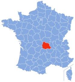
 Location of Puy-de-Dôme in France | |
| الإحداثيات: 45°42′N 03°13′E / 45.700°N 3.217°E | |
| البلد | فرنسا |
| Region | Auvergne |
| عاصمة الإقليم | Clermont-Ferrand |
| مراكز الدوائر | Ambert Issoire Riom Thiers |
| الحكومة | |
| • President of the General Council | Jean-Yves Gouttebel |
| المساحة | |
| • الإجمالي | 7٬970 كم² (3٬080 ميل²) |
| التعداد (يناير 2019) | |
| • الإجمالي | 662٬152 |
| • الترتيب | 38 |
| • الكثافة | 83/km2 (220/sq mi) |
| منطقة التوقيت | UTC+1 (CET) |
| • الصيف (التوقيت الصيفي) | UTC+2 (CEST) |
| Department number | 63 |
| الدوائر الادارية | 5 |
| Cantons | 61 |
| Communes | 470 |
| ^1 French Land Register data, which exclude estuaries, and lakes, ponds, and glaciers larger than 1 km2 | |
پوي دى دوم (بالفرنسية Puy-de-Dôme ؛ بالفرنسية: [pɥi də dom] (![]() استمع); Auvergnat: lo Puèi de Doma or lo Puèi Domat) هو إقليم في Auvergne-Rhône-Alpes region في وسط فرنسا. In 2019, it had a population of 662,152.[1] Its prefecture is Clermont-Ferrand and subprefectures are Ambert, Issoire, Riom, and Thiers.
استمع); Auvergnat: lo Puèi de Doma or lo Puèi Domat) هو إقليم في Auvergne-Rhône-Alpes region في وسط فرنسا. In 2019, it had a population of 662,152.[1] Its prefecture is Clermont-Ferrand and subprefectures are Ambert, Issoire, Riom, and Thiers.
مسمى على اسم بركان خامد بنفس الاسم، بوي دى دوم، its inhabitants were called Puydedomois in French until 2005. With effect from 2006, in response to a letter writing campaign, the name used for the inhabitants was changed by the Puy-de-Dôme General Council to Puydômois; this is the name that has since then been used in all official documents and publications.
التاريخ
Puy-de-Dôme is one of the original 83 departments created during the French Revolution on 4 March 1790. It was created from part of the former province of Auvergne. Originally, the department was to be called Mont-d'Or ("Golden Mountain"), but this was changed to Puy-de-Dôme following the intervention of Jean-François Gaultier de Biauzat, a local deputy, because of a concern that the name originally chosen risked attracting excessive unwelcome attention from the national taxation authorities.
الجغرافيا
Puy-de-Dôme is part of the current region of Auvergne-Rhône-Alpes and is bordered by the departments of Loire, Haute-Loire, Cantal, Corrèze, Allier, and Creuse. Parts of the department belong to the Parc naturel régional Livradois-Forez.
The department is in the Massif Central and boasts more than 80 volcanic craters. It is three hours from Paris and an hour from Lyon by highways A71 and A89. The A75 links it to the Mediterranean Sea.
البلدات الرئيسية
The most populous commune is Clermont-Ferrand, the prefecture. As of 2019, there are 10 communes with more than 10,000 inhabitants:[1]
| Commune | Population (2019) |
|---|---|
| Clermont-Ferrand | 147,865 |
| Cournon-d'Auvergne | 20,322 |
| Riom | 19,004 |
| Chamalières | 17,276 |
| Issoire | 15,296 |
| Pont-du-Château | 12,182 |
| Thiers | 11,784 |
| Aubière | 10,904 |
| Beaumont | 10,664 |
| Gerzat | 10,289 |
السكان
Population development since 1801:
|
| ||||||||||||||||||||||||||||||||||||||||||||||||||||||||||||||||||||||||||||||||||||
| Sources:[2][3] | |||||||||||||||||||||||||||||||||||||||||||||||||||||||||||||||||||||||||||||||||||||
الاقتصاد
The departmental seat, Clermont-Ferrand, is home to one of the country's best known manufacturing businesses and brands, Michelin. Thiers is the oldest industry place in Auvergne with its cutlery tradition from the 14th century.
The countryside lends itself to tourism and Puy-de-Dôme is a weekend destination for city dwellers. As of 2019, 10.1% of the usable homes in the department were being kept as second homes.[4]
السياسة
The department was the electoral constituency of Valéry Giscard d'Estaing, who served as President of the Republic from 1974 to 1981. The president of the Departmental Council is Lionel Chauvin, elected in July 2021.
Current National Assembly Representatives
National Assembly Representatives to the 15th Legislature
السياحة
The black Cathedral of Clermont-Ferrand
Saint-Floret, one of the most beautiful villages of France
The Puy de Dôme volcano
The Lac de Guéry in the Massif Central
انظر أيضاً
- Cantons of the Puy-de-Dôme department
- Communes of the Puy-de-Dôme department
- Arrondissements of the Puy-de-Dôme department
المصادر
وصلات خارجية
- (بالفرنسية) Prefecture website
- (بالفرنسية) General Council website
- (إنگليزية) Puy-de-Dome at the Open Directory Project
- ^ أ ب Populations légales 2019: 63 Puy-de-Dôme, INSEE
- ^ "Historique du Puy-de-Dôme". Le SPLAF.
- ^ "Évolution et structure de la population en 2016". INSEE.
- ^ Logement en 2019, INSEE
- ^ Nationale, Assemblée. "Assemblée nationale ~ Les députés, le vote de la loi, le Parlement français". Assemblée nationale.
- Pages using gadget WikiMiniAtlas
- صفحات بها مخططات
- Short description is different from Wikidata
- Coordinates on Wikidata
- Articles containing أوكسيتان (بعد 1500)-language text
- Pages using Lang-xx templates
- أقاليم فرنسا
- پوي دى دوم
- Massif Central
- تأسيسات 1790 في فرنسا
- Departments of Auvergne-Rhône-Alpes
- States and territories established in 1790


