ولاية بلخ
بلخ
بلخ | |
|---|---|
 خريطة أفغانستان موضح عليها موقع ولاية بلخ. | |
| الإحداثيات: 36°45′N 67°0′E / 36.750°N 67.000°E | |
| البلد | |
| العاصمة | مزار شريف |
| الحكومة | |
| • الوالي | محمد فرهد عظيمي |
| المساحة | |
| • الإجمالي | 16٬186٫3 كم² (6٬249٫6 ميل²) |
| التعداد (2021)[2] | |
| • الإجمالي | 1٬543٬464 |
| • الكثافة | 95/km2 (250/sq mi) |
| منطقة التوقيت | UTC+4:30 (توقيت أفغانستان) |
| ISO 3166 code | AF-BAL |
| اللغات الرئيسية | الدرية، الأوزبكية، التركمنانية، الپاشتو |
| [3] | |
بلخ Balkh (بالفارسية/الپاشتوية: بلخ) ، هي واحدة من ولايات أفغانستان الأربعة والثلاثين، وتقع شمال البلاد. اسمه مشتق من اسم المدينة القديمة بلخ، بالقرب من البلدة المعاصرة. عدد سكانها 1.245.1000 نسمة[4] وهم متعددي العرقية. مدينة مزار شريف هي عاصمة الولاية.
تبعد محافظة بلخ على بعد 56 كيلومتراً من الحدود الجنوبية لأوزبكستان، إرتفاعها من سطح البحر 1250 قدمًا، تقع كابول العاصمة منها على بعد 320 كيلومترًا في جنوبها الشرقي؛ تعتبر إحدى المناطق الخصبة في أفغانستان، تنتج القمح والحرير والقطن والثمار بأنواعها. يشکل الطاجيک الأغلبية الساحقة تليها الطائفة الأوزبکية فی المرتبة الثانية.
الجغرافيا
Balkh Province is situated in the northern part of Afghanistan, bordering Turkmenistan in the north-west, bordering Uzbekistan in the north, Tajikistan in the north-east, Kunduz Province in the east, Samangan Province in the south-east, Sar-e Pol Province in the south-west and Jowzjan Province in the west. The province covers an area of 16,840 km2. Nearly half of the province is mountainous or semi-mountainous terrain (48.7%) while half of the area (50.2%) is made up of flat land.[5]
التاريخ
التاريخ القديم
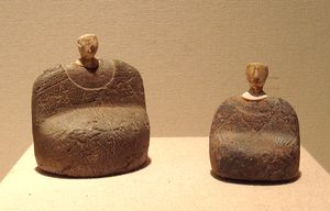
المجمع الأثري باختر-مرگوش (BMAC، ويُعرف أيضاً بإسم "حضارة جيحون") هو التسمية الأثرية الحديثة لثقافة من العصر البرونزي في آسيا الوسطى، تعود إلى ح. 2200–1700 BCE, located in present-day Turkmenistan, northern Afghanistan, southern Uzbekistan and western Tajikistan, centered on the upper Amu Darya (Oxus), in area covering ancient Bactria. Its sites were discovered and named by the Soviet archaeologist Viktor Sarianidi (1976). Bactria was the Greek name for the area of Bakhlo (modern Balkh), in what is now northern Afghanistan, and Margiana was the Greek name for the Persian satrapy of Margu, the capital of which was Merv, in today's Turkmenistan.
The early Greek historian Ctesias c. 400 BCE (followed by Diodorus Siculus) alleged that the legendary Assyrian king Ninus had defeated a Bactrian king named Oxyartes in ca. 2140 BC, or some 1000 years before the Trojan War. Ever since the discovery of cuneiform enabled actual Assyrian records to be deciphered in the 19th century, however, historians have ascribed little value to the Greek account.
According to some writers, Bactria was the homeland of Indo-European tribes who moved south-west into what is today Iran and into the north-western Indian Subcontinent (modern day Pakistan and India) around 2500–2000 BCE. Later, it became the northern province of the Achaemenid Empire.[6] It was in these regions, where the fertile soil of the mountainous country is surrounded by the Turanian desert, that the prophet Zoroaster (Zarathushtra) was said to have been born and gained his first adherents. Avestan, the language of the oldest portions of the Zoroastrian Avesta, was one of the old Iranian languages, and is the oldest attested member of the Eastern Iranian branch of the Iranian language family.
It is suggested by E. Herzfeld that Bactria once belonged to the Median empire.[7] It was annexed by the Achaemenid Persians in the 6th century BCE and together with Margiana it formed the twelfth satrapy of the Achaemenids.[8] After Darius III of Persia was defeated by Alexander the Great and killed in the ensuing chaos, his murderer Bessus, the satrap of Bactria, tried to organize a national resistance based on his satrapie but was captured by other warlords and delivered to Alexander. He was then tortured and killed.[9]
Alexander the Great conquered Sogdiana and Persia. However, in the south, beyond the Oxus, he met strong resistance. After two years of war Bactria was occupied by the Macedonians, but Alexander never successfully subdued the people. After Alexander's death, the Macedonian Empire was eventually divided up between several generals in Alexander's army. Bactria became part of Seleucus I, the founder of the Seleucid Empire.
"The famed Bactrian Empire of a thousand cities, wallowing in wealth (opulentissimum illud mille urbium Bactrianum imperium)"[10]
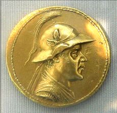
The many difficulties against which the Seleucid kings had to fight and the attacks of Ptolemy II of Egypt gave Diodotus, satrap of Bactria, the opportunity to declare independence (about 255 BCE) and conquer Sogdiana. He was the founder of the Greco-Bactrian Kingdom. Diodotus and his successors were able to maintain themselves against the attacks of the Seleucids—particularly from Antiochus III the Great, who was ultimately defeated by the Romans (190 BCE).
The Greco-Bactrians were so powerful that they were able to expand their territory as far as India:
- "As for Bactria, a part of it lies alongside Aria towards the north, though most of it lies above Aria and to the east of it. And much of it produces everything except oil. The Greeks who caused Bactria to revolt grew so powerful on account of the fertility of the country that they became masters, not only of Bactria and beyond, but also of India, as Apollodorus of Artemita says: and more tribes were subdued by them than by Alexander...."[11]
The Greco-Bactrians used Greek language for administrative purposes, and the local Bactrian language was also Hellenized, as suggested by its adoption of the Greek alphabet and Greek loanwords. In turn, some of these words were also borrowed by modern Pashto, the language of Afghanistan.[12]

The weakness of the Greco-Bactrians was shown by its sudden and complete overthrow, first by the Sakas, and then by the Yuezhi (who later became known as Kushans), who had conquered Bactria by the time of the visit of the Chinese envoy Zhang Qian (circa 127 BCE), who had been sent by the Han emperor to investigate lands to the west of China.[13]
Under the Sassanids the province would become part of the area known as Khorasan.[14]
Kujula Kadphises, the Guishuang xihou (or prince) of the Da Yuezhi, united the region in the early 1st century and laid the foundations for the powerful, but short-lived, Kushan Empire (1st to 3rd century CE), which was then overcome by the Sassanians from Persia. The name Daxia appears in Chinese from the 3rd century BCE to designate a mythical kingdom to the West, possibly a consequence of the first contacts with the expansion of the Greco-Bactrian Kingdom, and then is used by the explorer Zhang Qian in 126 BCE to designate Bactria.

The reports of Zhang Qian were put in writing in the Shiji ("Records of the Grand Historian") by Sima Qian in the 1st century BCE. They describe an important urban civilization of about one million people, living in walled cities under small city kings or magistrates. Daxia was an affluent country with rich markets, trading in an incredible variety of objects, coming as far as Southern China. By the time Zhang Qian visited Daxia, there was no longer a major king, and the Bactrian were suzerains to the nomadic Yuezhi, who were settled to the north of their territory beyond the Oxus (Amu Darya). Overall Zhang Qian depicted a rather sophisticated but demoralized people who were afraid of war.
Following these reports, the Chinese Emperor Wu Di was informed of the level of sophistication of the urban civilizations of Ferghana, Bactria and Parthia, and became interested in developing commercial relationship with them:
- "The Son of Heaven on hearing all this reasoned thus: Ferghana (Dayuan) and the possessions of Bactria (Daxia) and Parthia (Anxi) are large countries, full of rare things, with a population living in fixed abodes and given to occupations somewhat identical with those of the Chinese people, but with weak armies, and placing great value on the rich produce of China" (Hanshu, Former Han History).
These contacts immediately led to the dispatch of multiple embassies from the Chinese, which helped to develop the Silk Road.
القرن التاسع عشر
استولى الأفغان على مزار شريف عام 1852، وأصبحت في عام 1869 حاضرة كبيرة من حواضر تركستان الأفغانية. وتقع على بعد بضعة أميال من مدينة مزار شريف إلى جهة الغرب مدينة "بلخ" التاريخية.
وسبق أن أسست القوات السوفيتية في منطقة "دهدادي" قاعدة من قواعدها المركزية بعد احتلالها أفغانستان سنة 1979م، وشقت روسيا طريقاً من مزار شريف إلى مدينة "ترمذ" الأوزبكية الحدودية، ومدت جسراً على "آمودريا" وسموه "جسر الصداقة"؛ ومن ثَم إزدادت الأهمية الإستراتيجية للمدينة. ولما خرجت القوات السوفيتية من أفغانستان عام 1989م، كانت القوة الضاربة في المدينة المليشيات الجوزجانية، أو مليشيات "کِلم جم" التي كان يقودها الجنرال "عبد الرشيد دوستم". ولما ضاق الأمر بالرئيس الأفغاني الأسبق " محمد نجيب الله" بعد عام 1991م، أراد أن ينقل عاصمة أفغانستان إليها، إلا أنه لم يتمكن من ذلك.
لما خرجت حكومة الرئيس "رباني" من كابول بعد استيلاء طالبان عليها عام 1996م جعلتها عاصمة لها، إلى أن وقعت بيد طالبان بصورة نهائية يوم 8 أغسطس 1998. وحينما قررت أمريکا الحرب على أفغانستان طلبت من عبد الرشيد دوستم -الذي عمل مع كل القوى الأفغانية العميلة للروس وكذلك الأحزاب الإسلامية، وكان يعيش في تركيا- أن يعود إلى أفغانستان. وبدأ الهجوم على مزار شريف وساعده على ذلك "عطا محمد" القائد الميداني التابع للجمعية الإسلامية التابعة للرئيس الأفغاني السابق برهان الدين رباني.
الاتصال مع الصين
الحرب في أفغانستان
في 10 أغسطس 2021، بدأت حركة طالبان السعي للسيطرة على مزار شريف، كبرى مدن شمال أفغانستان بعد تعزيز مواقعها هناك، فيما تعتزم واشنطن استئناف مفاوضات الدوحة من أجل الضغط على الحركة لوقف هجومها العسكري. وقال مسلحو طالبان إنهم بدأو الهجوم على مزار الشريف كبرى مدن شمال أفغانستان وعاصمة ولاية بلخ. لكن السكان والمسؤولين الأفغان قالوا إن المسلحين لم يصلوا إليها بعد.[15]
من جهتها قالت الشرطة في ولاية بلخ إن أقرب موقع شهد معارك يبعد 30 كيلومترا على الأقل منها، متهمة طالبان بأنها تستخدم "الدعاية لترويع السكان". بدوره قال مرويس ستانيكزاي، الناطق باسم وزارة الداخلية الأفغانية في رسالة إلى وسائل الاعلام إن "العدو يتحرك الآن باتجاه مزار الشريف، لكن لحسن الحظ أحزمة الأمان (حول المدينة) قوية وتم صد العدو". ومزار الشريف مدينة تاريخية ومفترق طرق تجاري. وهي من الدعائم التي استندت إليها الحكومة للسيطرة على شمال البلاد. وسيشكل سقوطها ضربة قاسية جدا للسلطات.
وتعهد محمد عطا نور، الحاكم السابق لولاية بلخ والرجل القوي في مزار الشريف والشمال، تعهد بالمقاومة "حتى آخر قطرة دم". وكتب على تويتر: "أفضل أن أموت بكرامة على أن أموت في حالة من اليأس". من ناحية أخرى باتت طالبان تسيطر على ست من عواصم الولايات الأفغانية البالغ عددها 34، بعدما استولت قبل أيام على شبرغان معقل زعيم الحرب عبد الرشيد دوستم على مسافة حوالى 50 كيلومترا شمال ساري بول، والجمعة على زرنج عاصمة ولاية نيمروز البعيدة في جنوب غرب البلاد عند الحدود مع إيران.
وسيطرت على مدينة قندوز الكبيرة الواقعة في شمال شرق البلاد، وكذلك مدينتي ساري بول وتالقان، الأحد، في غضون ساعات قليلة، كما أضافت طالبان الاثنين إلى قائمتها مدينة أيبك البالغ عدد سكانها 120 ألف نسمة والتي سقطت من دون مقاومة. ووسط استمرار المعارك، فر آلاف السكان من شمال البلاد، ووصل الكثير منهم إلى كابول الاثنين، بعد رحلة لعشر ساعات في السيارة عبروا فيها العديد من حواجز طالبان.
تشكل السيطرة على قندوز الواقعة على مسافة 300 كيلومتر شمال كابول والتي احتلها المسلحون مرتين في 2015 و2016، وهي مفترق الطرق الاستراتيجي في شمال أفغانستان بين كابول وطاجيكستان، تشكل أكبر نجاح عسكري لطالبان منذ بدء الهجوم الذي شنته في مايو، مع بدء انسحاب القوات الدولية الذي يُتوقع أن ينتهي بحلول 31 أغسطس الجاري. وإثر تقدم طالبان يبدو بحسب خبراء أن الجيش الأفغاني غير قادر على وقف هجوم طالبان في الشمال، إلا أنه مستمر في مواجهة المسلحين في قندهار ولشكركاه، وهما معقلان تاريخيان للمسلحين في جنوب أفغانستان، وكذلك في هرات في غرب البلاد.
لكن هذه المقاومة تتم لقاء خسائر مدنية فادحة، إذا أفادت اليونيسف الإثنين عن مقتل عشرين طفلا على الأقل وإصابة 130 خلال الأيام الثلاثة الأخيرة في ولاية قندهار وحدها. من جانب آخر أعلنت الخارجية الأمريكية في بيان مساء 9 أغسطس: "سيتوجه السفير خليل زاد إلى الدوحة للمساعدة في صياغة استجابة دولية مشتركة للوضع المتدهور بسرعة في أفغانستان".
وأضافت أنه "سيحض طالبان على وقف هجومها العسكري والتفاوض على اتفاق سياسي، وهو السبيل الوحيد لتحقيق الاستقرار والتنمية في أفغانستان". وخلال الأسابيع الأخيرة، أوضحت إدارة بايدن أن واشنطن ستحافظ على "دعمها" للحكومة في كابول، خصوصا في ما يتعلق بالتدريب العسكري، لكن بالنسبة إلى بقية الأمور، على الأفغان ان يقرروا مصيرهم. وقال الناطق باسم البنتاغون جون كيربي، يوم الاثنين: "هذا بلدهم الذي يجب أن يدافعوا عنه. هذه معركتهم".
الحكم

التقسيمات الادارية
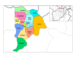
تنقسم ولاية بلخ إلى 15 مديرية:
| المديرية | العاصمة | السكان | المساحة[16] | الهوامش |
|---|---|---|---|---|
| بلخ | 97,055 | غالبيتها فارسيوان، مع بعض الأوزبك والهزارة. | ||
| چاربولك | 69,975 | غالبيتها پشتون، مع أقلية من فارسيوان (طاجيك وعرب).[17] | ||
| چاركنت | 32,306 | Majority Uzbeks, minority Kazakhs and Pashtuns, some Farsiwans. | ||
| چمتال | 81,311 | Majority Uzbeks, minority Farsiwans, Pashtuns and Hazaras. | ||
| دولت آباد | 79,638 | Majority Farsiwans, minority Uzbeks, Hazaras, Turkmens, Pashtuns. | ||
| دهدادي | 66,009 | Mixed Kyrgyz, Farsiwans and Hazaras. | ||
| كلدار | 17,932 | معظمها أوزبك | ||
| خلم | طاش قرغان | 49,207 | 91 قرية. خليط من الأوزبك، والفارسيوان (عرب و آيماق)، وپشتون، و هزارة. كانت جزءاً من ولاية سمنگان. | |
| كشنده | 49,083 | Majority Hazaras, minority Pashtuns and Uzbeks. تم إنشاء تقسيم فرعي داخلها عام 2005 | ||
| مارمل | 9,510 | Majority Farsiwans, minority Uzbeks, few Kyrgyz. | ||
| مزار شريف | مزار شريف | 375,181 | 40% Tajiks, 27% Pashtuns, 20% Hazara, 10% Uzbeks, 3% Turkmens.[18] | |
| نهر شاهي | 38,791 | Predominantly Farsiwans, some Uzbeks and Hazaras. | ||
| شولگره | 85,269 | 40% Farsiwans (Tajiks, Arabs), 20% Pashtuns (Kandahari, Baloch, Kuchi), 20% Hazaras, 20% Uzbeks.[19] | ||
| شور تپه | 30,314 | Predominantely Turkmens, few Uzbeks. | ||
| زاري | 42,367 | معظمها هزارة. اِقتُطِعت عام 2005 من مديرية كشنده. | ||
| بلخ | 1,509,183 | 16,186 | 40% طاجيك, 20% هزارة, 27.0% ترك (17.4% أوزبك, 1.7% قيرغيز, 7.4% تركمان, 0.5% Kazakhs), 18.3% پشتون (قندهاري، Kochi)[note 1] |
- ^ Note: "Predominantely" or "dominated" is interpreted as 99%, "majority" as 70%, "mixed" as 1/(number of ethnicities), "minority" as 30% and "few" or "some" as 1%.
الاقتصاد
Like in other parts of Afghanistan, agriculture plays an important part of Balkh's economy.[20] It is known for producing some of the sweetest melons and grapes.[21] It is expected that the province will witness a major agriculture boost in the near future after the Qush Tepa Canal is completed, which "will irrigate 500,000 hectares of land in Balkh, Jawzjan and Faryab provinces."[22] This will significantly increase Balkh's economy and population as many Afghans from other parts of the country will move to the province for employment purposes.
التعدين
On October 5, 2018, in Washington, D.C., Afghan officials signed a 30-year contract involving a $56 million investment by investment group Centar and its operating company Afghan Gold and Minerals Co. for exploration of an area covering 500 square km for copper, with development of mining due to begin thereafter.[23]
الرعاية الصحية
The percentage of households with clean drinking water increased from 8% in 2005 to 15% in 2011.[24] The percentage of births attended by a skilled birth attendant increased from 0% in 2005 to 20% in 2011. In 2018 Dr.Khalilullah Hekmati was appointed the Public Health Director which was followed by positive changes in the Health sector.[24]
التعليم
The overall literacy rate (6+ years of age) increased from 12% in 2005 to 23% in 2011.[24] The overall net enrolment rate (6–13 years of age) increased from 22% in 2005 to 46% in 2011.[24]
السكان
الرياضة


انظر أيضاً
المصادر
- ^ "Area and Administrative and Population". Islamic Republic of Afghanistan. 2013. Archived from the original on 2014-01-17. Retrieved 2014-02-03.
- ^ "Estimated Population of Afghanistan 2021-22" (PDF). National Statistic and Information Authority (NSIA). April 2021. Retrieved June 21, 2021.
- ^ "The U.S. Board on Geographic Name". U.S. Department of the Interior. Retrieved 2014-02-14.
- ^ خطأ استشهاد: وسم
<ref>غير صحيح؛ لا نص تم توفيره للمراجع المسماةcso - ^ خطأ استشهاد: وسم
<ref>غير صحيح؛ لا نص تم توفيره للمراجع المسماةmrrd - ^ Cotterell (1998), p. 59)
- ^ Herzfeld, Ernst (1968). The Persian Empire: Studies in geography and ethnography of the ancient Near East. F. Steiner. p. 344.
- ^ P. Leriche, "Bactria, Pre-Islamic period." Encyclopaedia Iranica, Vol. 3, 1998.
- ^ Holt (2005), pp. 41–43.
- ^ Justinus XLI 1.8.
- ^ Strabo,11.11.1
- ^ UCLA Language Project, Pashto, Link Archived 2009-01-03 at the Wayback Machine
- ^ Silk Road, North China, C. Michael Hogan, the Megalithic Portal, ed. Andy Burnham
- ^ خطأ استشهاد: وسم
<ref>غير صحيح؛ لا نص تم توفيره للمراجع المسماةEI - ^ "بعد سيطرتها على 6 من عواصم الولايات.. طالبان تسعى نحو "مزار الشريف" كبرى مدن شمال أفغانستان". روسيا اليوم. 2021-08-10. Retrieved 2021-08-10.
- ^ Afghanistan Geographic & Thematic Layers
- ^ https://www.afghan-bios.info/index.php?option=com_afghanbios&id=369&task=view&total=2436&start=458&Itemid=2
- ^ https://nps.edu/documents/105988371/107571254/Balkh_PDP_Provincial_profile.pdf/09d635b2-a75b-49e8-88c2-94d26ab54f7f
- ^ https://web.archive.org/web/20051027194649/http://www.aims.org.af:80/afg/dist_profiles/unhcr_district_profiles/northern/balkh/dpSholgara_11_04_02.pdf
- ^ "Bountiful Harvests Attract Farmers to New Horticultural System". The World Bank. September 14, 2015. Retrieved 2022-08-09.
- ^ "Balkh melon yield up but prices down this year". Pajhwok Afghan News. July 19, 2022. Retrieved 2022-08-09.
- ^ "Qush Tepa Canal to be completed before scheduled date". Pajhwok Afghan News. August 9, 2022. Retrieved 2022-08-09.
- ^ Mackenzie, James; Qadir Sediqi, Abdul (2018-10-07). "Afghanistan signs major mining deals in development push". reuters.com. Reuters. Retrieved 30 June 2020.
- ^ أ ب ت ث Archive, Civil Military Fusion Centre, https://www.cimicweb.org/AfghanistanProvincialMap/Pages/SarePul.aspx Archived 2014-05-31 at the Wayback Machine
وصلات خارجية
- Pages using gadget WikiMiniAtlas
- Short description is different from Wikidata
- Articles containing فارسية-language text
- Pages using multiple image with auto scaled images
- Coordinates on Wikidata
- Portal-inline template with redlinked portals
- Pages with empty portal template
- Articles with hatnote templates targeting a nonexistent page
- ولاية بلخ
- ولايات أفغانستان
- خراسان
