ولاية پروان
Parwan
پروان | |
|---|---|
Province | |
 ممر سالنگ أثناء الشتاء | |
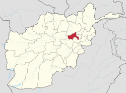
 خريطة أفغانستان، موضحة عليها ولاية پروان | |
| الإحداثيات: 35°00′N 69°00′E / 35.0°N 69.0°E | |
| Country | |
| العاصمة | چاريكار |
| الحكومة | |
| • الوالي | عبد البصير سالنگي |
| المساحة | |
| • الإجمالي | 5٬974 كم² (2٬307 ميل²) |
| التعداد (2011)[1] | |
| • الإجمالي | 631٬600 |
| • الكثافة | 110/km2 (270/sq mi) |
| منطقة التوقيت | UTC+4:30 |
| ISO 3166 code | AF-PAR |
| اللغات الرئيسية | داري وپاشتو[2] |
ولاية پروان (پروان: بالباشتو والفارسية) من إحدی المحافظات الـ 34 بأفغانستان تقع شمال العاصمة کابول. عاصمتها مدينة شاريکار وتبلغ مساحتها زهاء 3999 کيلو متر مربع وسکانها أکثر من 528000 نسمة.
تشتهر بروان بکثرة أشجار التوت وحدائق العنب وتعد من الأقاليم الهادئة فی البلاد. يشکل البشتون والطاجيک والهزارة معظم سکانها الأصليين. تتواجد ببروان وتحديداً في بلدة بغرام أکبر قاعدة عسکرية أمريکية بعد الاحتلال الأمريکي لأفغانستان. شَهِدت بروان حروباً کثيرة فی العقود الأخيرة وخاض المجاهدون الأفغان معارک طاحنة مع الجيش السوفياتي هناک.
التاريخ
Human habitation in Parwan province dates back to prehistoric times. Due to the fact that this province is located on the Silk Road and has a green and watery nature, this region has been of great importance throughout history.
Alexander the Great in 329 BC made the city of Charikar (in some traditions Bagram) the capital of his Eastern Empire, which is known as Charikar or Chare-Kar due to the existence of the central market. After spending some time in Parwan, Alexander spent the winter there. He built a fortress in his name near the entrance to the Salang Valley. Alexander built this city to protect the city of Kapisa (Kapisa) on the first slopes of present-day Jabal al-Saraj (ancient Parwan), known as Alexandria on the Caucasus, which is the modern Bagram. Many Macedonians and Greeks of Alexander's army remained there. The purpose of building the city was to establish a base for future operations beyond the Hindu Kush Mountains.
Parwan province is important in the Kushan period if Kansaka Kabir first declared Bagram as the summer capital of the Kushan Empire.
During the Sassanid period, Parwan was part of this empire and during the Arab invasion of Parwan in 792 AD, it was conquered by the Muslim Arabs .
الديمغرافيا والجغرافيا
چاريكار، سرخ بارسا، سالنک، جبل سراج، بگرام، غوربند، شينواري، شيخ علی وکوه صافي.
المقاطعات
| المقاطعة | العاصمة | التعداد (2013)[1] | المساحة[3] | ملاحظات |
|---|---|---|---|---|
| بگرام | 100,800 | طاجيك و پشتون | ||
| چاريكار (العاصمة) | 171,200 | طاجيك | ||
| غوربند | 94,100 | معظمهم پشتون و طاجيك | ||
| جبل سراج | 62,100 | معظمهم طاجيك | ||
| كوه صافي | 30,200 | معظمهم پشتون | ||
| سالنگ | 25,300 | الأغلبية طاجيك | ||
| سيد خيل | 44,300 | معظمهم طاجيك | ||
| شيخ علي | 24,000 | 2/3 ينتمي إلى the Daikalan and Naiman tribe of شيخ علي Hazaras who are Shia Muslims. 1/3 ينتمي إلى كرم علي و Qarlugh tribes of Sheikh Ali Hazaras who are Sunni Muslims. There is also a small community of سيد هزارة, سيد حسين أنوري ينتمي إلى هذه الطائفة. | ||
| شينواري | 39,900 | معظمهم پشتون و طاجيك | ||
| سرخ پارسا | 30,000 | معظمهم هزارة |
بلدات وقرى بارزة
الاقتصاد
معرض صور
- صور ولاية پروان
بالقرب من Shibar Pass that connects Parwan to Bamyan.
طريق في ولاية پروان، بالقرب من جسر سيد الواقع إلى الشمال مباشرة من قاعدة بگرام الجوية.
A member of the Afghan National Police trying to control local children awaiting the distribution of goods from the U.S. military for the winter months.
- وادي سالنگ
الهامش
- ^ أ ب "Settled Population of Parwan province by Civil Division, Urban, Rural and Sex-2012-13" (PDF). Islamic Republic of Afghanistan, Central Statistics Organization. Retrieved 2013-06-16.
- ^ "Parwaan Province". United Nations. Afghanistan's Ministry of Rural Rehabilitation and Development. Retrieved 2012-07-16.
- ^ Afghanistan Geographic & Thematic Layers


