وكالة المخابرات الفضائية الوطنية
 Seal of the U.S. National Geospatial-Intelligence Agency | |
 Flag of the U.S. National Geospatial-Intelligence Agency | |
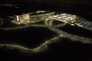
 NGA Campus East, headquarters of the agency; the building features trapezoidal windows, color-coded interior sections, and is bisected by an atrium that is large enough to hold the Statue of Liberty[1][2][3] | |
| استعراض الوكالة | |
|---|---|
| تشكلت | 1 أكتوبر 1996 (as the National Imagery and Mapping Agency) |
| agency السابقة |
|
| الاختصاص | U.S. Department of Defense |
| المقر الرئيسي | Fort Belvoir, Virginia, U.S.[2] 38°45′12″N 77°11′49″W / 38.7532°N 77.1969°W |
| الشعار الحادي | "Know the Earth... Show the Way... Understand the World" |
| الموظفون | About 16,000[4] |
| الميزانية السنوية | Classified (at least $4.9 billion, as of 2013)[5] |
| تنفيذي الوكالةs |
|
| الوكالة الأم | Department of Defense |
| الموقع الإلكتروني | www |
| تذييل | |
| [6] | |
The National Geospatial-Intelligence Agency (NGA) is a combat support agency under the United States Department of Defense and a member of the United States Intelligence Community,[8] with the primary mission of collecting, analyzing, and distributing geospatial intelligence (GEOINT) in support of national security. NGA was known as the National Imagery and Mapping Agency (NIMA) until 2003.
NGA headquarters, also known as NGA Campus East, is located at Fort Belvoir North Area in Virginia. The agency also operates major facilities in the St. Louis, Missouri area, as well as support and liaison offices worldwide. The NGA headquarters, at 2.3 million square feet (214,000 m2), is the third-largest government building in the Washington metropolitan area after The Pentagon and the Ronald Reagan Building.[9]
In addition to using GEOINT for U.S. military and intelligence efforts, the NGA provides assistance during natural and man-made disasters, and security planning for major events such as the Olympic Games.[10]
In September 2018, researchers at the National Geospatial-Intelligence Agency released a high resolution terrain map[11] (detail down to the size of a car, and less in some areas) of Antarctica, named the "Reference Elevation Model of Antarctica" (REMA).[12]
. . . . . . . . . . . . . . . . . . . . . . . . . . . . . . . . . . . . . . . . . . . . . . . . . . . . . . . . . . . . . . . . . . . . . . . . . . . . . . . . . . . . . . . . . . . . . . . . . . . . . . . . . . . . . . . . . . . . . . . . . . . . . . . . . . . . . . . . . . . . . . . . . . . . . . . . . . . . . . . . . . . . . . . .
Gallery
NGA headquarters' atrium
Letitia Long, director of the NGA, 2010–2014
See also
- Cartography
- Geographic Information System (GIS)
- GEOnet Names Server
- Geospatial engineering
- Geospatial Information Officer
- GIS use in the NGA
- Imagery intelligence
- Orthophoto
- Remote sensing
- Satellite imagery
- Small Sats
References
- ^ "BRAC side effect: Greener buildings". May 13, 2011.
- ^ أ ب "NGA Campus East Fact Sheet" (PDF). Archived from the original (PDF) on فبراير 21, 2014.
- ^ "Photo gallery: An alternative geography". projects.washingtonpost.com.
- ^ Frequently Asked Questions (FAQs) Archived نوفمبر 24, 2013 at the Wayback Machine. .nga.mil. Retrieved on July 21, 2013.
- ^ Gellman, Barton; Greg Miller (August 29, 2013). "U.S. spy network's successes, failures and objectives detailed in 'black budget' summary". The Washington Post. Retrieved August 29, 2013.
- ^ "GSP - GSP". www.esa.int.
- ^ "Rear Adm. Robert Sharp USN confirmed as new NGA director". intelligencecommunitynews.com. 28 December 2018. Retrieved 8 February 2019.
- ^ "10 U.S. Code § 441 - Establishment". LII / Legal Information Institute.
- ^ Serbu, Jared (2011-09-27). "Geospatial intelligence HQ is now DC's 3rd largest federal office building". Federal News Radio. Retrieved 2016-03-19.
- ^ "About NGA". Archived from the original on أكتوبر 6, 2014.
- ^ https://www.pgc.umn.edu/data/rema/
- ^ Stirone, Shannon (7 September 2018). "New Antarctica Map Is Like 'Putting on Glasses for the First Time and Seeing 20/20' – A high resolution terrain map of Earth's frozen continent will help researchers better track changes on the ice as the planet warms". The New York Times. Retrieved 9 September 2018.
Further reading
- Ambinder, Marc (May 5, 2011). "The Little-Known Agency That Helped Kill Bin Laden". The Atlantic. Explains the NGA's capabilities.
External links
- Official website
- GEOnet Names Server (GNS) - Database of foreign geographic feature names. Worldwide coverage excluding the United States and Antarctica, containing approximately 3.93 million features with 5.45 million names, and their coordinates
- Center for Geospatial Intelligence : University of Missouri - Columbia research center focused on GeoINT
- JP 2-03, Geospatial Intelligence Support to Joint Operations, 31 October 2012
- Commission Report on the National Imagery and Mapping Agency
- GeoIntelligence: A trade publication covering the uses of spatial technologies for national defense and homeland security by organizations such as NGA
- Ensor, David (December 13, 2002). "Secretive map agency opens its doors". CNN.
- DMA Receives Hammer Award, 26 January 1996
- Agency Provides More Than Just Maps
- The Center for Intelligence and Security Studies trains new analysts in Intelligence Analysis
خطأ لوا في package.lua على السطر 80: module 'Module:Authority control/auxiliary' not found.
- Pages using gadget WikiMiniAtlas
- Coordinates on Wikidata
- Official website different in Wikidata and Wikipedia
- United States Department of Defense agencies
- وكالات مخابرات أمريكية
- Military cartography
- مراقبة
- Military in Maryland
- National Geospatial-Intelligence Agency
- Government agencies established in 1996
- 1996 establishments in the United States
- Intelligence analysis agencies


