هيلونغجيانغ
| ||||||||||||||||||||||||||||||||||||||||||||||||||||||||||||||||||||||||||
| ||||||||||||||||||||||||||||||||||||||||||||||||||||||||||||||||||||||||||
| ||||||||||||||||||||||||||||||||||||||||||||||||||||||||||||||||||||||||||
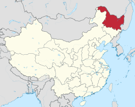
هيلونغجيانغ أو خـِيْلونگجيانگ (UK /ˌheɪlɒŋˈdʒæŋ/,[5] الأمريكي /ˈheɪˈlʊŋˈdʒjɑːŋ/[6]), تهجي الخريطة البريدية: Heilungkiang ؛ مانچو: Sahaliyan ula)، هي إحدى مقاطعات الصين وتقع في الجزء شمال شرق البلاد. تعني هـِيْلونگجيانگ "نهر التنين الأسود"، والذي يطلق عليه في الصين اسم نهر أمور. وعاصمتها هي هاربين. المقاطعة يحدها Jilin إلى الجنوب ومنغوليا الداخلية إلى الغرب. It also shares a border مع روسيا (أوبلاست آمور، الأوبلاست الذاتي اليهودي، كراي خبروڤسك وكراي پريمورسكي وأوبلاست آمور) إلى الشمال والشرق. The capital and the largest city of the province is Harbin. Among Chinese provincial-level التقسيمات الادارية، خـِيْلونگجيانگ هي sixth-largest by total area و15th-most populous.
تأخذ المقاطعة اسمها من نهر خـِيْلونگ (الاسم الصيني للآمور)، الذي يميز الحدود بين جمهورية الصين الشعبية وروسيا. تضم خـِيْلونگجيانگ أقصى نقاط الصين شمالاً (في مدينة موهى على الآمور) وأقصى النقاط شرقاً (عند التقاء نهري الآمور وأوسوري).
خـِيْلونگجيانگ لها انتاج زراعي معتبر،[7] ومواد خام، مثل الأخشاب والنفط والفحم.
. . . . . . . . . . . . . . . . . . . . . . . . . . . . . . . . . . . . . . . . . . . . . . . . . . . . . . . . . . . . . . . . . . . . . . . . . . . . . . . . . . . . . . . . . . . . . . . . . . . . . . . . . . . . . . . . . . . . . . . . . . . . . . . . . . . . . . . . . . . . . . . . . . . . . . . . . . . . . . . . . . . . . . . .
أصل الاسم
"Heilongjiang" literally means Black Dragon River, which is the Chinese name for the more well known western name, Amur. The one-character abbreviation is 黑 (pinyin: Hēi). The Manchu name of the region is Sahaliyan ula (literally, "Black River"), from which the name of Sakhalin is derived, and the Mongolian name with the same meaning is Qaramörin. It is sometimes spelt "Heilungkiang", especially in older English texts.
التاريخ
Ancient Chinese records and other sources state that Heilongjiang was inhabited by people such as the Sushen, Buyeo, the Mohe, Balhae, and the Khitan. Mongolic Donghu people lived in Inner Mongolia and the western part of Heilongjiang.[8] Some names are Manchu or Mongolian.[9] The eastern portion of Heilongjiang was ruled by the kingdom of Balhae بين القرنين السابع والعاشر. The Jurchen Jin dynasty (1115–1234) that subsequently ruled much of north China arose ضمن حدود هيلونغجيانغ الحديثة.
Heilongjiang as an administrative entity was created in 1683, during the Kangxi era of the Manchu Qing Dynasty, from the northwestern part of the Jilin province.[10] This Heilongjiang Province only included the western part of today's Heilongjiang Province, and was under the supervision of the General of Heilongjiang (Sahaliyan Ula i Jiyanggiyūn) (the title is also translated as the Military Governor of Heilongjiang; jiyanggiyūn is the Manchu reading of the Chinese word 將軍 jiāngjūn; "military leader, general" and is cognate with Japanese shōgun), whose power extended, according to the Treaty of Nerchinsk, as far north as the Stanovoy Mountains. The eastern part of what's today Heilongjiang remained under the supervision of the General of Jilin (Girin i Jiyanggiyūn), whose power reached the Sea of Japan. These areas deep in Manchuria were closed off to Han Chinese migration.
The original seat of the Military Governor of Heilongjiang, as established in 1683, was in Heilongjiang City (also known as Aigun or Heihe, or, in Manchu, Saghalien Ula), located on the Amur River. However, already in 1690 the seat of the governor was transferred to Nenjiang (Mergen) on the Nen River, and, in 1699, further south to Qiqihar. According to modern historians, the moves may have been driven by supply considerations: Nenjiang and Qiqihar are connected by a convenient waterway (Nen River) with southern Manchuria, whereas accessing Aigun (Heihe) would require either sailing all the way down the Sungari River until its confluence with the Amur and then up the Amur to Heihe, or using a portage over the Lesser Xing'an Mountains between the Nen River valley and the Amur valley. An additional advantage of Qiqihar may have been its location at the junction of a northbound road (to Nenjiang) and a westbound one (to Mongolia), enabling its garrison to defend both against the Russians and the Ölöt Mongols.[11]
Little Qing Military presence existed north of Aigun. According to the 18th- and early-20th-century European sources, and the reports of the Russians in the 1850s, the farthest Qing "advance guard" post was at Ulusu-Modon (Ulussu-Mudan) (Chinese: 乌鲁苏穆丹), near the Amur River's famous S-shaped meander. (The post was actually on the left bank of the river, lost to the Russians in 1860.)
In 1858 and 1860, the Qing government was forced to give up all land beyond the Amur and Ussuri Rivers to the Russian Empire, cutting off the Qing Empire from the Sea of Japan and giving Heilongjiang its present northern and eastern borders. At the same time, Manchuria was opened to Han Chinese migration by the Qing government. By the early twentieth century, due to the Chuang Guandong, the Han Chinese had become the dominant ethnic group in the region.[12]
In 1931, Japanese forces invaded Heilongjiang. In 1932, the Japanese completed their conquest of the province, which became part of the Japanese puppet state of مانچوكو.
In 1945, Japanese forces in Manchuria were defeated by the Soviet Army. During the Chinese Civil War, Soviet forces aided the Chinese communists. Heilongjiang became the first province to be completely controlled by the communists and Harbin the first major city to be controlled by them.
At the beginning of communist rule, Heilongjiang included only the western portion of the present-day province, and had its capital at Qiqihar. The remaining area was the province of Songjiang; its capital was Harbin. In 1954, these two provinces were merged into present-day Heilongjiang. During the Cultural Revolution, Heilongjiang was also expanded to include Hulunbuir League and some other areas previously in Inner Mongolia; this has since mostly been reversed.
الجغرافيا
Heilongjiang is a land of varied topographies. Much of the province is dominated by mountain ranges such as the Greater Khingan Range and Lesser Khingan Range, Zhangguangcai Mountains, Laoye Mountains, and Wanda Mountains. The highest peak is Mount Datudingzi at 1,690 metres (5,540 ft), located on the border with Jilin province. The Greater Khingan Range contains China's largest remaining virgin forest and is an important area for China's forestry industry.
The east and southwest of the province, which are relatively flat and low in altitude, feature the Muling River, the Naoli River, the Songhua River, the Nen River, and the Mudan River, all tributaries of the Amur, while the northern border forms part of the Amur valley. Xingkai Lake (or Khanka Lake) is found on the border with Russia's Primorsky Krai.
Climate
A humid continental climate (Köppen Dwa or Dwb) predominates in the province, though areas in the far north are subarctic (Köppen Dwc).[13] Winters are long and bitter, with an average of −31 to −15 °C (−24 to 5 °F) in January, and summers are short and warm to very warm with an average of 18 to 23 °C (64 to 73 °F) in July. The annual average rainfall is 400 to 700 millimetres (16 to 28 in), concentrated heavily in summer. Clear weather is prevalent throughout the year, and in the spring, the Songnen Plain and the Sanjiang Plain provide abundant sources of wind energy.
The province's largest cities include Harbin, Qiqihar, Mudanjiang, Jiamusi, Daqing, Jixi, Shuangyashan, Hegang, Qitaihe, Yichun, and Heihe.
| City | July (°C) | July (°F) | January (°C) | January (°F) |
|---|---|---|---|---|
| Harbin | 27.9/18.3 | 82.2/64.9 | –12.5/–24.1 | 9.5/–11.4 |
| Jiamusi | 27.6/17.7 | 81.7/63.9 | –12.7/–24 | 9.1/–11.2 |
| Hegang | 26.5/17.4 | 80/63.3 | –12.7/–20.8 | 9.1/–5.4 |
| Yichun | 27.1/15.5 | 80.8/59.9 | –14.5/–29.1 | 5.9/–20.4 |
أهم المدن
أهم المدن:
البنية التحتية
التقسيمات الإدارية
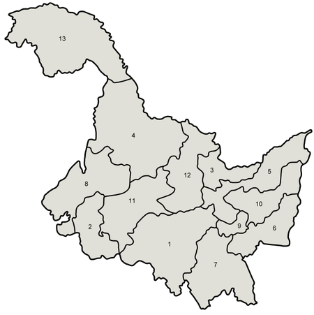
تنقسيم هـِيْلونگجيانگ إلى 13 تقسيم على مستوى محافظة، ويشمل 12 مدينة بمستوى محافظة وولاية واحدة:
| خريطة | # | الاسم | هانزي | هانيو پنين | Type |
|---|---|---|---|---|---|
| |||||
| 1 | هاربين | 哈尔滨市 | Hā'ěrbīn Shì | مدينة بمستوى محافظة | |
| 2 | Daqing | 大庆市 | Dàqìng Shì | مدينة بمستوى محافظة | |
| 3 | Hegang | 鹤岗市 | Hègǎng Shì | مدينة بمستوى محافظة | |
| 4 | هـِيْخى | 黑河市 | Hēihé Shì | مدينة بمستوى محافظة | |
| 5 | جياموسي | 佳木斯市 | Jiāmùsī Shì | مدينة بمستوى محافظة | |
| 6 | Jixi | 鸡西市 | Jīxī Shì | مدينة بمستوى محافظة | |
| 7 | Mudanjiang | 牡丹江市 | Mǔdānjiāng Shì | مدينة بمستوى محافظة | |
| 8 | چيچيهار | 齐齐哈尔市 | Qíqíhā'ěr Shì | مدينة بمستوى محافظة | |
| 9 | Qitaihe | 七台河市 | Qītáihé Shì | مدينة بمستوى محافظة | |
| 10 | Shuangyashan | 双鸭山市 | Shuāngyāshān Shì | مدينة بمستوى محافظة | |
| 11 | Suihua | 绥化市 | Suíhuà Shì | مدينة بمستوى محافظة | |
| 12 | Yichun | 伊春市 | Yīchūn Shì | مدينة بمستوى محافظة | |
| 13 | Daxing'anling | 大兴安岭地区 | Dàxīng'ānlǐng Dìqū | مدينة بمستوى محافظة |
. . . . . . . . . . . . . . . . . . . . . . . . . . . . . . . . . . . . . . . . . . . . . . . . . . . . . . . . . . . . . . . . . . . . . . . . . . . . . . . . . . . . . . . . . . . . . . . . . . . . . . . . . . . . . . . . . . . . . . . . . . . . . . . . . . . . . . . . . . . . . . . . . . . . . . . . . . . . . . . . . . . . . . . .
السياسة
الاقتصاد
الديموغرافيا
تمثل قومية الهان غالبية سكان هـِيْلونگجيانگ، بينما تتضمن الأقليات العرقية الأخرى المانشو، الكوريون، المنغول، الهوي، داؤر, شيبه, اوروچين، هژن والروس.
| المجموعات العرقية في هـِيْلونگجيانگ (تقديرات 2000) | ||
|---|---|---|
| القومية | السكان | النسبة |
| الهان | 34,465,039 | 95.20% |
| المانشو | 1,037,080 | 2.86% |
| كوريون | 388,458 | 1.07% |
| منغول | 141,495 | 0.39% |
| الهوي | 124,003 | 0.34% |
| Daur | 43,608 | 0.12% |
| Xibe | 8,886 | 0.03% |
لا يضم أفراد جيش التحرير الشعبي في الخدمة.
المصدر: قسم السكان والإحصائيات الاجتماعية والعلميةوالتكنولوجية في مكتب الصين الوطني للإحصاء (国家统计局人口和社会科技统计司) and Department of Economic Development of the State Ethnic Affairs Commission of China (国家民族事务委员会经济发展司), eds. Tabulation on Nationalities of 2000 Population Census of China (《2000年人口普查中国民族人口资料》). 2 vols. Beijing: Nationalities Publishing House (民族出版社), 2003. (ISBN 7-105-05425-5)
الأديان
Most of Heilongjiang's residents are either non-religious or practice Chinese folk religions, including Taoism. Manchu shamanism is practiced by many Manchu people. البوذية الصينية والبوذية التبتية have an important presence in the province.
الثقافة
الإعلام
تلفزيون هـِيْلونگجيانگ، وراديو اقتصاد هاربين.
السياحة
الجامعات والكليات
الرياضات
المصادر
- ^ "Doing Business in China – Survey". Ministry Of Commerce – People's Republic Of China. Archived from the original on 5 August 2013. Retrieved 5 August 2013.
- ^ "Communiqué of the Seventh National Population Census (No. 3)". National Bureau of Statistics of China. 11 May 2021. Retrieved 11 May 2021.
- ^ GDP-2020 is a preliminary data "Home - Regional - Quarterly by Province" (Press release). China NBS. March 1, 2021. Retrieved March 23, 2021.
- ^ "Sub-national HDI" (PDF). 2019. Retrieved 2021-12-31.
- ^ Longman, J.C. (2008). Longman Pronunciation Dictionary (3 ed.). Pearson Education ESL. ISBN 978-1405881173.
- ^ قالب:Cite Merriam-Webster
- ^ "Heilongjiang and China's Food Security". Stratfor. 2012-03-05. Retrieved 2019-10-20.
- ^ Origins of Minority Ethnic Groups in Heilongjiang Archived 2014-03-22 at the Wayback Machine
- ^ 浅谈黑龙江省地名的特点. iqh.net.cn (in Chinese (China)).
- ^ Edmonds, Richard Louis (1985). Northern Frontiers of Qing China and Tokugawa Japan: A Comparative Study of Frontier Policy. University of Chicago, Department of Geography; Research Paper No. 213. p. 6. ISBN 0-89065-118-3.
- ^ Edmonds (1985), pp. 115–117
- ^ Patrick Fuliang Shan, "Taming China's Wilderness: Immigration, Settlement, and the Shaping of the Heilongjiang Frontier, 1900–1931", Ashgate, 2014, ISBN 978-1-4094-6389-4
- ^ Updated Asian map of the Köppen climate classification system
وصلات خارجية
- Pages using gadget WikiMiniAtlas
- CS1 uses الصينية-language script (zh)
- CS1 Chinese (China)-language sources (zh-cn)
- Short description is different from Wikidata
- Articles containing صينية-language text
- Coordinates on Wikidata
- Articles containing منغولية-language text
- Articles containing Chinese-language text
- Articles with hatnote templates targeting a nonexistent page
- خـِيْلونگجيانگ
- مقاطعات الصين
- بالهاي
- دول ومناطق تأسست في 1954
