مقاطعة أگستا، ڤرجينيا
Augusta County | |
|---|---|
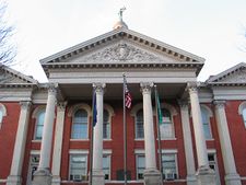
 The Augusta County Courthouse in March 2005 | |
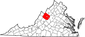
 الموقع ضمن ولاية Virginia | |
 موقع Virginia ضمن الولايات المتحدة | |
| الإحداثيات: خطأ لوا في وحدة:Coordinates على السطر 612: bad argument #1 to 'sub' (string expected, got nil). | |
| البلد | |
| State | |
| تأسست | 1738 |
| السمِيْ | Princess Augusta of Saxe-Gotha |
| Seat | Staunton |
| Largest community | Stuarts Draft |
| المساحة | |
| • الإجمالي | 971 ميل² (2٬510 كم²) |
| • البر | 967 ميل² (2٬500 كم²) |
| • الماء | 3٫9 ميل² (10 كم²) 0.4%% |
| التعداد | |
| • Estimate (2015) | 74٬314 |
| • الكثافة | 77/sq mi (30/km2) |
| منطقة التوقيت | UTC−5 (Eastern) |
| • الصيف (التوقيت الصيفي) | UTC−4 (EDT) |
| Congressional district | 6th |
| الموقع الإلكتروني | www |
مقاطعة أگستا إنگليزية: Augusta County هي إحدى المقاطعات في ولاية ڤرجينيا في الولايات المتحدة.
. . . . . . . . . . . . . . . . . . . . . . . . . . . . . . . . . . . . . . . . . . . . . . . . . . . . . . . . . . . . . . . . . . . . . . . . . . . . . . . . . . . . . . . . . . . . . . . . . . . . . . . . . . . . . . . . . . . . . . . . . . . . . . . . . . . . . . . . . . . . . . . . . . . . . . . . . . . . . . . . . . . . . . . .
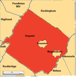
Adjacent counties and independent cities
- Staunton (Enclaved)
- Waynesboro (Enclaved)
- Pendleton County, West Virginia (North)
- Rockingham County (Northeast)
- Albemarle County (East)
- Nelson County (Southeast)
- Rockbridge County (Southwest)
- Bath County (West)
- Highland County (Northwest)
Districts
The county is divided into seven magisterial districts: Beverley Manor, Middle River, North River, Pastures, Riverheads, South River, and Wayne.
School systems
The county is serviced by Augusta County Public Schools.
National protected areas
- Blue Ridge Parkway (part)
- George Washington National Forest (part)
- Shenandoah National Park (part)
Regional park
Major highways
Demographics
| التعداد التاريخي | |||
|---|---|---|---|
| التعداد | Pop. | %± | |
| 1790 | 10٬886 | — | |
| 1800 | 11٬712 | 7٫6% | |
| 1810 | 14٬308 | 22٫2% | |
| 1820 | 16٬742 | 17�0% | |
| 1830 | 19٬926 | 19�0% | |
| 1840 | 19٬628 | −1٫5% | |
| 1850 | 24٬610 | 25٫4% | |
| 1860 | 27٬749 | 12٫8% | |
| 1870 | 28٬763 | 3٫7% | |
| 1880 | 35٬710 | 24٫2% | |
| 1890 | 37٬005 | 3٫6% | |
| 1900 | 32٬370 | −12٫5% | |
| 1910 | 32٬445 | 0٫2% | |
| 1920 | 34٬671 | 6٫9% | |
| 1930 | 38٬163 | 10٫1% | |
| 1940 | 42٬772 | 12٫1% | |
| 1950 | 34٬154 | −20٫1% | |
| 1960 | 37٬363 | 9٫4% | |
| 1970 | 44٬220 | 18٫4% | |
| 1980 | 53٬732 | 21٫5% | |
| 1990 | 54٬677 | 1٫8% | |
| 2000 | 65٬615 | 20�0% | |
| 2010 | 73٬750 | 12٫4% | |
| 2016 (تق.) | 74٬997 | [1] | 1٫7% |
| U.S. Decennial Census[2] 1790-1960[3] 1900-1990[4] 1990-2000[5] 2010-2013[6] | |||
Area Populations
According to the 2010 US Census data, below are the populations of the two towns and select unincorporated communities within Augusta County:
| # | Town | Population |
|---|---|---|
| 1 | Grottoes | 2,668 |
| 2 | Craigsville | 923 |
| # | Unincorporated Community | Population |
|---|---|---|
| 1 | Stuarts Draft | 9,235 |
| 2 | Fishersville | 7,462 |
| 3 | Verona | 4,239 |
| 4 | Weyers Cave | 2,473 |
| 5 | Crimora | 2,209 |
| 6 | Lyndhurst | 1,490 |
| 7 | Dooms | 1,327 |
| 8 | Swoope | 1,323 |
| 9 | Jolivue | 1,129 |
| 10 | Greenville | 832 |
| 11 | Fort Defiance | 780 |
| 12 | Sherando | 688 |
| 13 | Mount Sidney | 663 |
| 14 | Churchville | 194 |
Government
| Year | Republican | Democratic | Third Parties |
|---|---|---|---|
| 2016 | 72.0% 26,163 | 22.5% 8,177 | 5.5% 2,003 |
| 2012 | 70.2% 23,624 | 28.1% 9,451 | 1.8% 597 |
| 2008 | 69.4% 23,120 | 29.5% 9,825 | 1.2% 393 |
| 2004 | 74.4% 22,100 | 23.6% 7,019 | 2.0% 585 |
| 2000 | 70.2% 17,744 | 26.3% 6,643 | 3.5% 884 |
| 1996 | 60.9% 13,458 | 27.0% 5,965 | 12.1% 2,679 |
| 1992 | 59.0% 12,896 | 23.7% 5,190 | 17.3% 3,780 |
| 1988 | 75.1% 13,251 | 23.7% 4,170 | 1.2% 213 |
| 1984 | 79.2% 15,308 | 20.2% 3,899 | 0.6% 116 |
| 1980 | 64.3% 11,011 | 30.4% 5,202 | 5.3% 907 |
| 1976 | 57.5% 8,452 | 38.3% 5,626 | 4.2% 614 |
| 1972 | 81.4% 9,106 | 15.8% 1,766 | 2.8% 309 |
| 1968 | 57.9% 6,313 | 18.6% 2,028 | 23.5% 2,559 |
| 1964 | 51.7% 4,327 | 48.2% 4,039 | 0.1% 6 |
| 1960 | 67.4% 4,034 | 32.0% 1,914 | 0.7% 41 |
| 1956 | 68.1% 3,466 | 29.1% 1,484 | 2.8% 142 |
| 1952 | 70.0% 3,414 | 29.8% 1,453 | 0.3% 12 |
| 1948 | 48.9% 1,690 | 39.2% 1,355 | 11.8% 409 |
| 1944 | 44.2% 2,319 | 55.5% 2,913 | 0.3% 15 |
| 1940 | 38.7% 1,768 | 60.8% 2,774 | 0.5% 22 |
| 1936 | 36.5% 1,668 | 62.8% 2,872 | 0.7% 31 |
| 1932 | 36.4% 1,541 | 61.5% 2,606 | 2.1% 90 |
| 1928 | 64.0% 2,679 | 36.0% 1,507 | |
| 1924 | 38.7% 1,265 | 58.8% 1,920 | 2.5% 80 |
| 1920 | 44.0% 1,707 | 54.3% 2,106 | 1.7% 66 |
| 1916 | 32.0% 845 | 66.2% 1,751 | 1.8% 48 |
| 1912 | 22.9% 568 | 62.7% 1,556 | 14.4% 356 |
. . . . . . . . . . . . . . . . . . . . . . . . . . . . . . . . . . . . . . . . . . . . . . . . . . . . . . . . . . . . . . . . . . . . . . . . . . . . . . . . . . . . . . . . . . . . . . . . . . . . . . . . . . . . . . . . . . . . . . . . . . . . . . . . . . . . . . . . . . . . . . . . . . . . . . . . . . . . . . . . . . . . . . . .
Board of Supervisors
- Beverley Manor district: David A. Karaffa (I)
- Middle River district: Larry J. Wills (R)
- North River district: Marshall W. Pattie (I)
- Pastures district: Tracy C. Pyles, Jr. (I)
- Riverheads district: Michael L. Shull (R)
- South River district: Carolyn S. Bragg (R)
- Wayne district: Jeffrey A. Moore (R)
Constitutional Officers
- Clerk of the Circuit Court: John B. Davis (R)
- Commissioner of the Revenue: W. Jean Shrewsbury (R)
- Commonwealth's Attorney: Tim Martin (R)
- Sheriff: Donald L. Smith (I)
- Treasurer: Richard T. Homes (R)
Augusta County is represented by Republican Emmett W. Hanger in the Virginia Senate, Republican Richard P. "Dickie" Bell, Republican Ben L. Cline, and Republican R. Steven "Steve" Landes in the Virginia House of Delegates, and Republican Robert W. "Bob" Goodlatte in the U.S. House of Representatives.
Economy
According to the County's 2011 Comprehensive Annual Financial Report,[8] the top employers in the county are:
| # | Employer | # of Employees |
|---|---|---|
| 1 | Augusta County Public Schools | 1,000+ |
| 2 | Augusta Health | 1,000+ |
| 3 | McKee Foods | 500-999 |
| 4 | Hershey | 500-999 |
| 5 | Target | 500-999 |
| 6 | AAF-McQuay | 500-999 |
| 7 | Hollister | 250-499 |
| 8 | Blue Ridge Community College | 250-499 |
| 9 | Augusta Correctional Center | 250-499 |
| 10 | Ply Gem | 250-499 |
Communities
The independent cities of Staunton and Waynesboro (incorporated as such in 1902 and 1948 respectively) are located within the boundaries of Augusta County, but are not a part of the county, despite Staunton's status as the county seat. Most county administrative offices, however, are located in Verona, rather than in Staunton.
Towns
- Craigsville
- Grottoes (partial)
Census-designated places
Other unincorporated communities
Notable people
- Thomas Adams, born in Augusta County, member of the Virginia House of Burgesses and signer of the Articles of Confederation[9]
- Robert Allen, born in Augusta County, United States Congressman from Tennessee[9]
- George Caleb Bingham (1811–1879), born in Augusta County, noted painter and State Treasurer of Missouri [9]
- Gideon Blackburn (1772–1838), born in Augusta County, noted clergyman and founder of Blackburn College[9]
- John Brown, lawyer and statesman
- Samuel Brown, born in Augusta County, noted surgeon and editor[9]
- John Wilson Campbell, born in Augusta County, United States Congressman from Ohio [9]
- William Campbell, born in Augusta County, militia leader in the American Revolutionary War[9]
- John Colter (c.1774–May 7, 1812(?)), born near Stuarts Draft, was a member of the Lewis and Clark Expedition (1804−1806); best remembered for his 1807-1808 explorations as the first person of European descent to enter the region now known as Yellowstone National Park and the Grand Tetons
- Samuel Doak, (1749–1830), born in Augusta County, noted Presbyterian clergyman, founder of Washington College, the first college west of the Alleghenies, noted abolitionist[9]
- Ida Stover Eisenhower (1862-1946), mother of President Dwight D. Eisenhower, was born in Mount Sidney, Augusta County
- John H. Fulton, (died 1836), born in Augusta County, United States Congressman from Virginia[9]
- John P. Gaines, (1795–1857), born in Augusta County, United States Congressman from Kentucky and governor of the Oregon Territory.[9]
- John D. Imboden, (1823–1895), born in Augusta County, member of the Virginia General Assembly, Confederate Army cavalry general and partisan fighter in the American Civil War.[9]
- "Irish" John Lewis (1678–1762), opened up what is now Augusta County to settlement.[10]
- Thomas Lewis, Jr., born in Augusta County, United States Congressman from Virginia.[9]
- William J. Lewis, (1766–1828), born in Augusta County, United States Congressman from Virginia.[9]
- Robert D. Lilley, (1836–1886), born in Greenville, Augusta County, Confederate Army general in the American Civil War.[9]
- Benjamin Logan, (c.1742-1803), born in Augusta County, United States Congressman from Kentucky.[9]
- George Mathews, (1739–1812), born in Augusta County, United States Congressman and Governor of Georgia.[9] Member of the Mathews family.
- Sampson Mathews, (c. 1737 -1806), born in Augusta County, Virginia State Senator and Revolutionary War officer. Member of the Mathews family.
- Robert McKnight (c.1789-1846), born in Augusta County, moved to St. Louis, Missouri in 1809, member of a trading expedition under Zebulon Pike to Santa Fe, New Mexico in 1812, captured by Spanish and imprisoned until 1821, eventually renounced his United States citizenship, moved to Mexico, and became owner of the Santa Rita del Cobre copper mine in Chihuahua (now New Mexico).[9]
- Thomas McKnight, businessman and member of Wisconsin Territorial Council[11]
انظر أيضاً
- Augusta County Sheriff's Office
- National Register of Historic Places listings in Augusta County, Virginia
References
- ^ "Population and Housing Unit Estimates". Retrieved June 9, 2017.
- ^ "U.S. Decennial Census". United States Census Bureau. Archived from the original on May 12, 2015. Retrieved December 31, 2013.
{{cite web}}: Unknown parameter|deadurl=ignored (|url-status=suggested) (help) - ^ "Historical Census Browser". University of Virginia Library. Retrieved December 31, 2013.
- ^ "Population of Counties by Decennial Census: 1900 to 1990". United States Census Bureau. Retrieved December 31, 2013.
- ^ "Census 2000 PHC-T-4. Ranking Tables for Counties: 1990 and 2000" (PDF). United States Census Bureau. Retrieved December 31, 2013.
- ^ خطأ استشهاد: وسم
<ref>غير صحيح؛ لا نص تم توفيره للمراجع المسماةQF - ^ http://uselectionatlas.org/RESULTS
- ^ "Augusta County, Virginia Comprehensive Annual Financial Report, for the Year ended June 30, 2009" (PDF). Retrieved 2011-11-04.[dead link]
- ^ أ ب ت ث ج ح خ د ذ ر ز س ش ص ض ط ظ Who Was Who in America, Historical Volume, 1607-1896. Chicago: Marquis Who's Who. 1963.
- ^ John Meriwether McAllister and Mrs. Lura May Boulton Tandy (1906). Genealogies of the Lewis and kindred families. Columbia, Missouri: E. W. Stephens Publishing Company.
- ^ 'The History of Dubuque County,' Western Historical, 1880, Biographical Sketch of Thomas McKnight, pg. 975
للاستزادة
- Peyton's History of Augusta County, Virginia (1882), searchable online edition of the 1882 edition by J. Lewis Peyton.
- Waddell's Annals of Augusta County, Virginia, from 1726 to 1871, searchable online edition of the 1902 second edition by Jos. A. Waddell.
- Augusta County Resources, a Rootsweb page of historical and genealogical links and references, including maps.
. . . . . . . . . . . . . . . . . . . . . . . . . . . . . . . . . . . . . . . . . . . . . . . . . . . . . . . . . . . . . . . . . . . . . . . . . . . . . . . . . . . . . . . . . . . . . . . . . . . . . . . . . . . . . . . . . . . . . . . . . . . . . . . . . . . . . . . . . . . . . . . . . . . . . . . . . . . . . . . . . . . . . . . .
وصلات خارجية
- Augusta County at the Open Directory Project
- Augusta County official website
- Augusta County Economic Development Agency
- Augusta County Facts and Genealogy Resources

|
Rockingham County | Pendleton County, West Virginia | Highland County | 
|
| Albemarle County | Bath County | |||
| Nelson County | Rockbridge County |
- CS1 errors: unsupported parameter
- Articles with dead external links from October 2016
- Pages using gadget WikiMiniAtlas
- Short description is different from Wikidata
- مقاطعات Virginia
- Articles containing إنگليزية-language text
- Pages using Lang-xx templates
- Jct template errors
- Pages using US Census population needing update
- Pages using div col with unknown parameters
- Coordinates on Wikidata
- Virginia counties
- Augusta County, Virginia
- 1738 establishments in the Thirteen Colonies
- مقاطعات ولاية ڤرجينيا الأمريكية


