مقاطعة إسكس، ڤرجينيا
Essex County | |
|---|---|
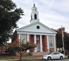
 Essex County Courthouse in Tappahannock | |
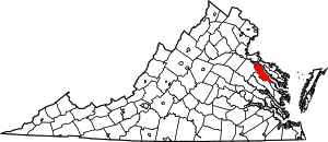
 الموقع ضمن ولاية Virginia | |
 موقع Virginia ضمن الولايات المتحدة | |
| الإحداثيات: 37°56′N 76°57′W / 37.94°N 76.95°W | |
| البلد | |
| State | |
| تأسست | 1692 |
| Seat | Tappahannock |
| Largest town | Tappahannock |
| المساحة | |
| • الإجمالي | 286 ميل² (740 كم²) |
| • البر | 257 ميل² (670 كم²) |
| • الماء | 29 ميل² (80 كم²) 10.1%% |
| التعداد | |
| • Estimate (2015) | 11٬130 |
| • الكثافة | 40/sq mi (15/km2) |
| منطقة التوقيت | UTC−5 (Eastern) |
| • الصيف (التوقيت الصيفي) | UTC−4 (EDT) |
| Congressional district | 1st |
| الموقع الإلكتروني | www |
مقاطعة إسكس إنگليزية: Essex County هي إحدى المقاطعات في ولاية ڤرجينيا في الولايات المتحدة الأمريكية.
المقاطعات المجاورة
- Westmoreland County – north
- Richmond County – northeast
- Middlesex County – southeast
- King and Queen County – south
- Caroline County – west
- King George County – northwest
National protected area
- Rappahannock River Valley National Wildlife Refuge (part) Hutchinson unit, Thomas unit
الديمغرافيا
| التعداد التاريخي | |||
|---|---|---|---|
| التعداد | Pop. | %± | |
| 1790 | 9٬122 | — | |
| 1800 | 9٬508 | 4٫2% | |
| 1810 | 9٬376 | −1٫4% | |
| 1820 | 9٬909 | 5٫7% | |
| 1830 | 10٬521 | 6٫2% | |
| 1840 | 11٬309 | 7٫5% | |
| 1850 | 10٬206 | −9٫8% | |
| 1860 | 10٬469 | 2٫6% | |
| 1870 | 9٬927 | −5٫2% | |
| 1880 | 11٬032 | 11٫1% | |
| 1890 | 10٬047 | −8٫9% | |
| 1900 | 9٬701 | −3٫4% | |
| 1910 | 9٬105 | −6٫1% | |
| 1920 | 8٬542 | −6٫2% | |
| 1930 | 6٬976 | −18٫3% | |
| 1940 | 7٬006 | 0٫4% | |
| 1950 | 6٬530 | −6٫8% | |
| 1960 | 6٬690 | 2٫5% | |
| 1970 | 7٬099 | 6٫1% | |
| 1980 | 8٬864 | 24٫9% | |
| 1990 | 8٬689 | −2�0% | |
| 2000 | 9٬989 | 15�0% | |
| 2010 | 11٬151 | 11٫6% | |
| 2016 (تق.) | 11٬123 | [1] | −0٫3% |
| U.S. Decennial Census[2] 1790-1960[3] 1900-1990[4] 1990-2000[5] 2010-2013[6] | |||
Essex is represented by Republican Ryan T. McDougle in the Virginia Senate, Republican M. Keith Hodges in the Virginia House of Delegates, and Republican Robert J. "Rob" Wittman in the U.S. House of Representatives.
أظهر
Presidential elections results
التجمعات
البلدة
التجمعات غير المشهرة
|
|
|
انظر أيضاً
الهامش
- ^ "Population and Housing Unit Estimates". Retrieved June 9, 2017.
- ^ "U.S. Decennial Census". United States Census Bureau. Archived from the original on May 12, 2015. Retrieved January 2, 2014.
{{cite web}}: Unknown parameter|deadurl=ignored (|url-status=suggested) (help) - ^ "Historical Census Browser". University of Virginia Library. Retrieved January 2, 2014.
- ^ "Population of Counties by Decennial Census: 1900 to 1990". United States Census Bureau. Retrieved January 2, 2014.
- ^ "Census 2000 PHC-T-4. Ranking Tables for Counties: 1990 and 2000" (PDF). United States Census Bureau. Retrieved January 2, 2014.
- ^ خطأ استشهاد: وسم
<ref>غير صحيح؛ لا نص تم توفيره للمراجع المسماةQF - ^ Leip, David. "Dave Leip's Atlas of U.S. Presidential Elections". uselectionatlas.org.
وصلات خارجية

|
Richmond County | Westmoreland County | King George County | 
|
| Caroline County | ||||
| Middlesex County | King and Queen County |
تصنيفات:
- CS1 errors: unsupported parameter
- Pages using gadget WikiMiniAtlas
- Short description is different from Wikidata
- مقاطعات Virginia
- Articles containing إنگليزية-language text
- Pages using Lang-xx templates
- Pages using US Census population needing update
- Coordinates on Wikidata
- Virginia counties
- Essex County, Virginia
- 1692 establishments in the British Empire
- مقاطعات ڤرجينيا
