مـيسا ڤردى، المنتزه الوطني
| منتزه مـِسا ڤرده الوطني Mesa Verde National Park | |
|---|---|
IUCN category II (national park) | |
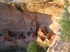
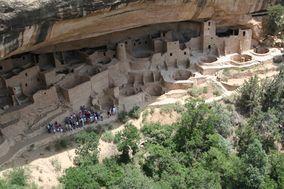 قصر الجرف | |
| الموقع | مقاطعة مونتيزوما، كولورادو الولايات المتحدة أمريكا الجنوبية |
| أقرب مدينة | كورتز |
| المساحة | 52,485 acres (21,240 ha) 52,253 acres (21,146 ha) federal[1] |
| تأسست | 29 يونيو 1906 |
| الزوار | 572,329 (in 2011)[2] |
| الهيئة الحاكمة | مصلحة المنتزهات الوطنية |
| النوع | ثقافي |
| المعيار | iii |
| التوصيف | 1978 (القسم الثاني) |
| الرقم المرجعي | 27 |
| الولاية | الولايات المتحدة |
| المنطقة | أوروپا وأمريكا الجنوبية |
| التوصيف | October 15, 1966 |
| الرقم المرجعي | 66000251 |
منتزه مـِسا ڤردا الوطني Mesa Verde National Park، هو منتزه وطني أمريكي وضمن قائمة اليونسكو للتراث العالمي ويقع في مقاطعة مونتيزوما، كولورادو، الولايات المتحدة. وهو أكبر منطقة حفاظ أثرية في الولايات المتحدة.[3] تأسس المنتزه عام 1906 بقرار من الرئيس الأمريكي ثيودور روزڤلت لحماية أحد أفضل المنحدرات الصخرية المحفوظة في العالم، أو كما قال، "حفظ أعمال الإنسان". وهو المتنزه الوطني الثقافي الوحيد الموجود بجانب منظومة منتزه وطني.[4] يحتل المنتزه مساحة 81.4 كم² بالقرب من الزوايا الأربعة ويضم أطلال منازل وقرى بناها شعوب الپويبلوان القديمة، ويطلق عليهم أحيانا الأناسازي. يوجد بالمنتزه أكثر من أربعة آلاف موقع أثري وأكثر من 600 منحدر صخري لشعوب الپويبلو.
. . . . . . . . . . . . . . . . . . . . . . . . . . . . . . . . . . . . . . . . . . . . . . . . . . . . . . . . . . . . . . . . . . . . . . . . . . . . . . . . . . . . . . . . . . . . . . . . . . . . . . . . . . . . . . . . . . . . . . . . . . . . . . . . . . . . . . . . . . . . . . . . . . . . . . . . . . . . . . . . . . . . . . . .
الجغرافيا والمناخ
| Climate data for منتزه مـِسا ڤرده الوطني (1981−2010) | |||||||||||||
|---|---|---|---|---|---|---|---|---|---|---|---|---|---|
| Month | Jan | Feb | Mar | Apr | May | Jun | Jul | Aug | Sep | Oct | Nov | Dec | Year |
| Record high °F (°C) | 62 (17) |
68 (20) |
73 (23) |
84 (29) |
94 (34) |
101 (38) |
102 (39) |
101 (38) |
94 (34) |
85 (29) |
75 (24) |
67 (19) |
102 (39) |
| Mean daily maximum °F (°C) | 39.6 (4.2) |
42.6 (5.9) |
49.7 (9.8) |
58.4 (14.7) |
68.8 (20.4) |
80.0 (26.7) |
85.3 (29.6) |
82.4 (28.0) |
74.7 (23.7) |
62.2 (16.8) |
49.1 (9.5) |
39.7 (4.3) |
61.0 (16.1) |
| Mean daily minimum °F (°C) | 19.5 (−6.9) |
22.8 (−5.1) |
28.7 (−1.8) |
34.0 (1.1) |
42.6 (5.9) |
51.0 (10.6) |
57.4 (14.1) |
56.2 (13.4) |
48.9 (9.4) |
37.8 (3.2) |
28.0 (−2.2) |
20.0 (−6.7) |
37.2 (2.9) |
| Record low °F (°C) | −20 (−29) |
−15 (−26) |
2 (−17) |
4 (−16) |
17 (−8) |
27 (−3) |
38 (3) |
38 (3) |
26 (−3) |
10 (−12) |
−3 (−19) |
−15 (−26) |
−20 (−29) |
| Average precipitation inches (mm) | 1.77 (45) |
1.63 (41) |
1.71 (43) |
1.30 (33) |
1.04 (26) |
0.53 (13) |
1.64 (42) |
2.29 (58) |
1.87 (47) |
1.69 (43) |
1.57 (40) |
1.54 (39) |
18.57 (472) |
| Average snowfall inches (cm) | 17.9 (45) |
15.6 (40) |
11.1 (28) |
4.5 (11) |
0.3 (0.76) |
0 (0) |
0 (0) |
0 (0) |
0 (0) |
1.6 (4.1) |
8.2 (21) |
14.4 (37) |
73.6 (187) |
| Average precipitation days (≥ 0.01 in) | 7.2 | 7.9 | 8.0 | 6.6 | 6.4 | 4.0 | 9.3 | 10.6 | 7.9 | 6.9 | 6.4 | 7.4 | 88.6 |
| Average snowy days (≥ 0.1 in) | 6.5 | 6.6 | 5.7 | 2.6 | 0.3 | 0 | 0 | 0 | 0 | 0.9 | 3.2 | 5.9 | 31.6 |
| [بحاجة لمصدر] | |||||||||||||
التاريخ الجيولوجي
التاريخ
سكان مـِسا ڤرده

أشهر الأماكن
| پويبلو | الصورة | التعليق |
|---|---|---|
| Balcony House | 
|
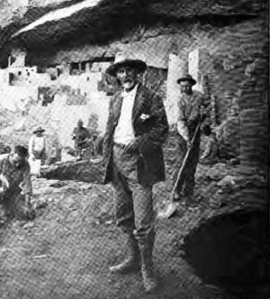
Set on a high ledge facing east, Balcony House with 45 rooms and 2 kivas, would have been cold for its residents in the winter. The modern visitor enters by climbing a 32-foot ladder and a crawling through a 12-foot tunnel. The exit, a series of toe-holds in a cleft of the cliff, was believed to be the only entry and exit route for the cliff dwellers, which made the small village easy to defend and secure. One log was dated at AD 1278 so it was likely built not long before the Mesa Verde people migrated out of the area.[6][7] It was officially excavated by Jesse Nusbaum, one of the first Superintendents of Mesa Verde National Park, in 1910.[8] Visitors can enter Balcony House through ranger-guided tours.[9] This photo is of Emmett Harryson, a Navajo, at a T-shaped doorway at Balcony House (1929). |
| Cliff Palace | 
|
This multi-storied ruin, the largest and best-known of the cliff dwellings in Mesa Verde, is located in the largest cave in the center of the Great Mesa. It was south- and southwest-facing, providing greater warmth from the sun in the winter. The site had 200 rooms, including storage rooms, open courts, walkways, and 23 kivas. Dating back more than 700 years, the dwelling is constructed of sandstone, wooden beams, and mortar.[10] Many of the rooms were brightly painted.[7][11] |
| Long House | 
|
Located on the Wetherill Mesa, Long House is the second-largest village, for about 150 people. The location was excavated as part of the Wetherhill Mesa Archaeological Project during the years 1959 through 1961.[12] The 150 rooms are not clustered like the standard cliff dwellings, and they are not one of the most elegant set of buildings. Stones were used without shaping for fit and stability. Two overhead ledges contain more rooms. One ledge seems to include an overlook with small holes in the wall to see the rest of the village below. A spring is accessible within several hundred feet and seeps are located in the rear of the village.[7]Long Houses were structures designed to expand as needed to hold large extended families.[13] |
| Mesa Verde Reservoirs | 
|
These ancient reservoirs, built by the Ancient Puebloans,[7] on September 26, 2004, became a National Civil Engineering Historic Landmark.[14] |
| Mug House | This ruin situated on Wetherill Mesa contains 94 rooms, a large kiva, and a nearby reservoir. It received its name from four mugs the Charles Mason and the Wetherill brothers found strung together on a string.[7] This ceremonial structure has a keyhole shape, due to a recess behind the fireplace and a deflector, that is considered an element of the Mesa Verde style. The rooms clustered around the kiva formed part of the courtyard, indicating the kiva would have been roofed.[بحاجة لمصدر] | |
| Oak Tree House | 
|
Oak Tree House and neighboring Fire Temple can be visited via a 2-hour ranger-guided hike.[15] |
| Spruce Tree House | 
|
Spruce Tree House is the third-largest village, within several hundred feet of a spring, and had 130 rooms and eight kivas. It was constructed sometime between AD 1211 and 1278. It is believed anywhere from 60 to 80 people lived there at one time.[16] Because of its protective location, it is well preserved.[7][16] The short trail to Spruce House begins at the Chapin Mesa Archeological Museum.[17] |
| Square Tower House | 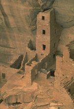
|
The Square Tower House is one of the stops on the Mesa Top Loop Road driving tour.[17] The tower that gives this site its name is the tallest structure in Mesa Verde. This cliff dwelling was occupied between AD 1200 and 1300.[بحاجة لمصدر] Square Tower House was the tallest man-made structure in the United States of America until mid 1800s.[18] |
الاكتشاف
اوته
المستكشفون الإسپان
. . . . . . . . . . . . . . . . . . . . . . . . . . . . . . . . . . . . . . . . . . . . . . . . . . . . . . . . . . . . . . . . . . . . . . . . . . . . . . . . . . . . . . . . . . . . . . . . . . . . . . . . . . . . . . . . . . . . . . . . . . . . . . . . . . . . . . . . . . . . . . . . . . . . . . . . . . . . . . . . . . . . . . . .
المستشكفون الأمريكان في عقد 1870 و1880
گوستاڤ نوردنسكيولد
المنتزه الوطني
إعلانه منتزه وطني
المعالم الهامة
خدمات المنتزه
منتزه جبل أوته القبلي المجاور
أشجار معدلة ثقافياً
معرض الصور
صور أخرى من مـِسا ڤرده
Round tower, Cliff Palace. Photo by Ansel Adams, 1941
مسح ضوئي بالليزر
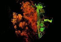
Plan of entire Spruce Tree House from above, cut from a laser scan
Laser scan section of the four-story Square Tower House
انظر أيضاً
مـِسا ڤرده
- Mesa Verde Wilderness
- Ute Mountain Tribal Park in Mesa Verde
- Yucca House National Monument تحت ادارة منتزه مـِسا ڤرده
Other neighboring Ancient Pueblo sites in Colorado
- Anasazi Heritage Center
- Canyons of the Ancients National Monument
- Crow Canyon Archaeological Center
- Hovenweep National Monument
Other cultures in the Four Corners region
Early American cultures
الهوامش
- الهوامش
- المراجع
- ^ "Listing of acreage as of December 31, 2011". Land Resource Division, National Park Service. Retrieved مارس 7, 2012.
- ^ "NPS Annual Recreation Visits Report". National Park Service. Retrieved مارس 7, 2012.
- ^ http://www.chicagotribune.com/travel/ct-5-places-to-learn-on-vacation-pueblo-colorado,0,758178.photo
- ^ http://www.coloradodirectory.com/nationalparks/mesaverde.html
- ^ "NOWData - NOAA Online Weather Data". National Oceanic and Atmospheric Administration. Retrieved December 6, 2012.
- ^ خطأ استشهاد: وسم
<ref>غير صحيح؛ لا نص تم توفيره للمراجع المسماةCasey - ^ أ ب ت ث ج ح خطأ استشهاد: وسم
<ref>غير صحيح؛ لا نص تم توفيره للمراجع المسماةWenger - ^ "Mesa Verde Balcony House". Aramark: Parks and Destinations. Retrieved أكتوبر 23, 2011.
- ^ "Balcony House". Mesa Verde National Park. U.S. National Park Service. Retrieved سبتمبر 21, 2011.
- ^ Cliff House Mesa Verde National Park Points of Interestقالب:Accessdate
- ^ خطأ استشهاد: وسم
<ref>غير صحيح؛ لا نص تم توفيره للمراجع المسماةWatson - ^ "Long House". Mesa Verde National Park. U.S. National Park Service. 2007-07-26. Retrieved يناير 12, 2012.
- ^ Snow: Archaeology of Native North America
- ^ Beard, Valerie. November 2004 Newsletter. American Society of Civil Engineerقالب:Accessdate
- ^ New 2011 Backcountry Hikes. National Park Serviceقالب:Accessdate
- ^ أ ب "Spruce Tree House". Mesa Verde National Park. U.S. National Park Service. 2007-07-26. Retrieved يناير 12, 2012.
- ^ أ ب Self-Guided Tours: Chapin Mesa. Mesa Verde National Parkقالب:Accessdate
- ^ http://www.sunilshinde.com/2013/04/square-tower-house-ruins-mesa-verde-national-park.html
34. Snow, Dean R. "Chapter 6." Archaeology of Native North America. Boston: Prentice Hall, 2010. Print.
قراءات إضافية
- Richard West Sellars, A Very Large Array: Early Federal Historic Preservation--The Antiquities Act, Mesa Verde, and the National Park Service Act (background and legislative history) published by the University of New Mexico School of Law, 2007.
- Fewkes, J. Walter for the United States Department of the Interior. (1910). Reports of the Department of the Interior - 1909 - Volume 1. Washington, D.C.: Government Printing Office.
- Noble, David Grant. (1995). Ancient Ruins of the Southwest. Flagstaff, Arizona: Northland Publishing. ISBN 0-87358-530-5
- Nordenskiöld, Gustaf. (1893). Ruiner af Klippboningar I Mesa Verde's Cañons. Stockholm: P. A. Norstedt & Söner.
- Nordenskiöld, Gustaf. (1893) The Cliff Dwellings of the Mesa Verde, Chicago: P.A. Norstedt & Söner.
- Oppelt, Norman T. (1989) Guide to Prehistoric Ruins of the Southwest. Boulder, Colorado: Pruett Publishing. ISBN 0-87108-783-9.
. . . . . . . . . . . . . . . . . . . . . . . . . . . . . . . . . . . . . . . . . . . . . . . . . . . . . . . . . . . . . . . . . . . . . . . . . . . . . . . . . . . . . . . . . . . . . . . . . . . . . . . . . . . . . . . . . . . . . . . . . . . . . . . . . . . . . . . . . . . . . . . . . . . . . . . . . . . . . . . . . . . . . . . .
وصلات خارجية
- Mesa Verde National Park (National Park Service)
- Mesa Verde National Park (UNESCO World Heritage Centre)
- Mesa Verde Digital Media Archive (creative commons-licensed photos, laser scans, panoramas), data on Spruce Tree House, Fire Temple, and Square Tower House from a National Park Service/CyArk research partnership
 Mesa Verde National Park travel guide from Wikivoyage
- Articles with hatnote templates targeting a nonexistent page
- Missing redirects
- IUCN Category II
- Pages using infobox protected area with unknown parameters
- Articles with unsourced statements from December 2012
- Articles with unsourced statements from September 2011
- مـِسا ڤرده، المنتزه الوطني
- Cliff dwellings
- مساكن شعوب پوِبلو
- مباني ومنشآت پوِبلوية
- مواقع أثرية پوِبلوية قديمة في كولورادو
- متاحف أثرية في كولورادو
- سكة حديد دنڤر وريو گراندى
- Historic districts in Colorado
- معالم في كولورادو
- متاحف في مقاطعة مونتيزوما، كولورادو
- منتزهات وطنية في كولورادو
- مواقع أثرية على السجل الوطني للأماكن التاريخية في كولورادو
- علم آثار الأمريكان الأصليين
- تاريخ الأمريكي الأصلي في كولورادو
- متاحف الأمريكان الأصليين في كولورادو
- حضارات واحات أمريكا
- أماكن محمية تأسست في 1906
- أماكن محمية في مقاطعة مونتيزوما، كولورادو
- مدن قبل التاريخ في الولايات المتحدة
- أطلال في الولايات المتحدة
- مواقع التراث العالمي في الولايات المتحدة


