كنگستون، جاميكا
كنگستون، جاميكا
Kingston, Jamaica | |
|---|---|
 Downtown Kingston and the Port of Kingston | |
| الشعار: A city which hath foundations[1] | |
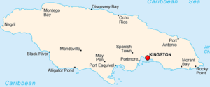 موقع كنگستون في جاميكا | |
| الإحداثيات: 17°58′17″N 76°47′35″W / 17.97139°N 76.79306°W | |
| البلد | جاميكا |
| المقاطعة | سري |
| Parish | Kingston St. Andrew |
| Established | 22 July 1692 |
| المساحة | |
| • Parish | 480 كم² (190 ميل²) |
| المنسوب | 9 m (30 ft) |
| التعداد (2011) | |
| • Parish | 662٬435[2] |
| • الترتيب | 65th in North America 1st in Jamaica |
| • العمرانية | 1٬190٬000 |
| منطقة التوقيت | UTC−5 (EST) |
| الموقع الإلكتروني | ksamc.gov.jm |
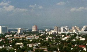
كنگستون (Kingston) هي عاصمة جاميكا وأكبر مدنها. تقع المدينة في الساحل جنوب الشرقي للبلاد. بالنسبة لنصف الكرة الأرضية الغربي فإن كينغستون تعتبر أكبر المدن المتحدثة باللغة الإنجليزية الواقعة جنوب الولايات المتحدة الأمريكية. تقع في مقاطعة سوري، في دائرة كينغستون الإدارية. تأسست عام 1693. Kingston is the largest English-speaking city south of the United States in the Western Hemisphere.[3]
The local government bodies of the parishes of Kingston and Saint Andrew were amalgamated by the Kingston and St. Andrew Corporation Act of 1923, to form the Kingston and St. Andrew Corporation (KSAC). Greater Kingston, or the "Corporate Area" refers to those areas under the KSAC; however, it does not solely refer to Kingston Parish, which only consists of the old downtown and Port Royal.[4] Kingston Parish had a population of 89,057, and St. Andrew Parish had a population of 573,369 in 2011[2] Kingston is only bordered by Saint Andrew to the east, west and north. The geographical border for the parish of Kingston encompasses the following communities: Tivoli Gardens, Denham Town, Rae Town, Kingston Gardens, National Heroes Park, Bournemouth Gardens, Norman Gardens, Rennock Lodge, Springfield and Port Royal, along with portions of Rollington Town, Franklyn Town, and Allman Town.[5][6]
The city proper is bounded by Six Miles to the west, Stony Hill to the north, Papine to the northeast, and Harbour View to the east, which are communities in urban and suburban Saint Andrew. Communities in rural St. Andrew such as Gordon Town, Mavis Bank, Lawrence Tavern, Mt. Airy, and Bull Bay would not be described as being in Kingston city.[7]
مثل كنجستون القلب التجاري والصناعي لجامايكا. وبالمدينة مصافٍ للنفط ومصانع للإسمنت والكيميائيات والنسيج. وتنامت كنجستون سريعًا بعد سنة 1692 عندما دمر زلزال مدينة بورت رويال المجاورة. وفي وقت وجيز حلت كنجستون محل بورت رويال كمركز تجاري. وأصبحت العاصمة سنة 1872م.
. . . . . . . . . . . . . . . . . . . . . . . . . . . . . . . . . . . . . . . . . . . . . . . . . . . . . . . . . . . . . . . . . . . . . . . . . . . . . . . . . . . . . . . . . . . . . . . . . . . . . . . . . . . . . . . . . . . . . . . . . . . . . . . . . . . . . . . . . . . . . . . . . . . . . . . . . . . . . . . . . . . . . . . .
التاريخ
Kingston was founded on 22 July 1692,[8][9] shortly after the 1692 earthquake that devastated Port Royal in 1692; the original section of the city which was situated at the bottom of the Liguanea Plains was laid out to house survivors of that earthquake.[10]
Before the earthquake, Kingston's functions were purely agricultural.[10] The earthquake survivors set up a camp on the sea front. Approximately two thousand people died due to mosquito-borne diseases. Initially the people lived in a tented camp on Colonel Barry's Hog Crawle. The town did not begin to grow until after the further destruction of Port Royal by fire in 1703. Surveyor John Goffe drew up a plan for the town based on a grid bounded by North, East, West, and Harbour Streets. The new grid system of the town was designed to facilitate commerce, particularly the system of main thoroughfares 66 feet (20 m) across, which allowed transportation between the port and plantations farther inland.[11] By 1716, it had become the largest town and the centre of trade for Jamaica. The government sold land to people with the regulation that they purchase no more than the amount of the land that they owned in Port Royal, and only land on the sea front. Gradually, wealthy merchants began to move their residences from above their businesses to the farm lands north on the plains of Liguanea.[10][11]
The first free school, Wolmers's, was founded in 1729 and there was a theatre, first on Harbour Street and then moved in 1774 to North Parade.[12] Both are still in existence.[12] In 1755 the governor, Sir Charles Knowles, had decided to transfer the government offices from Spanish Town to Kingston. It was thought by some to be an unsuitable location for the Assembly in proximity to the moral distractions of Kingston, and the next governor rescinded the Act. However, by 1780 the population of Kingston was 11,000, and the merchants began lobbying for the administrative capital to be transferred from Spanish Town, which was by then eclipsed by the commercial activity in Kingston.[12]
The Church of St. Thomas, on King Street, the chief thoroughfare, was first built before 1699 but was rebuilt after the earthquake in 1907.[9] By the end of the 18th century, the city contained more than 3,000 brick buildings.[13] The harbour fostered trade. It was involved in several naval wars of the 18th century. Kingston took over the functions of Spanish Town (the capital at the time). These functions included agriculture, commercial, processing and a main transport hub to and from Kingston and other sections of the island.[13]
In 1788, Kingston had a population of 25,000, which was about a tenth of the overall population of the island. One in every four people living in Kingston was white, but there was a large population of free people of color there too; two out of every five people living in Kingston were free. The remaining three-fifths of Kingston's population was made up of black slaves.[13]
The government passed an act to transfer the government offices to Kingston from Spanish Town, which occurred in 1872.[9] In 1882, there was a large fire in Kingston.[14] In 1892, electricity first came to Jamaica, when it was supplied to a coal-burning steam-generating plant on Gold Street in Kingston.[15]
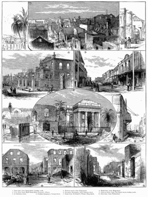
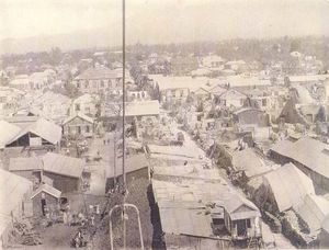
In 1907, 800 people died in another earthquake known as the 1907 Kingston earthquake, destroying nearly all the historical buildings south of Parade in the city.[16] That was when a height restriction of no more than 60 feet (18 m) was instituted on buildings in the city centre. These three-story-high buildings were built with reinforced concrete. Construction on King Street in the city was the first area to breach this building code.[16]
During the 1930s, island-wide riots led to the development of trade unions and political parties to represent workers.[17]
The city became home to the Mona campus of the University of the West Indies. It was founded in 1948, with 24 medical students.[9]
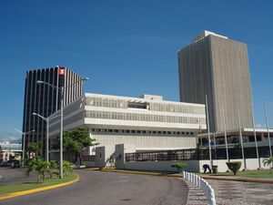
In the 1960s, the international attention of reggae music at that time coincided with the expansion and development of 95 acres (38 ha) of the Kingston city centre waterfront area; by the 1980s, most of the old buildings were demolished by construction companies and the entire waterfront was re-developed with hotels, shops, offices, cultural centres, and cruise and cargo ship facilities.[9]
In 1966, Kingston was the host city to the Commonwealth Games.[18]
In the 1980 general elections, the democratic socialist People's National Party (PNP) government was voted out, and subsequent governments have been more market-oriented and focused on tourism and relations with the United States, which reflected the "turbulent" and "volatile" era, in which Cuba and the United States fought for cultural control over Jamaica.[19]
In the 1990s, crime increased in the region and several riots were reported, including one in 1999 against a rise of fuel prices.[20] In 1999, the Jamaican government ordered army troops to patrol the streets of Kingston in an attempt to curb the violent crime.[20] In 2001, army troops and armoured vehicles used force to "restore order" in Kingston after "three days of unrest leave at least 27 people dead".[20]
In 2010, the Kingston unrest, an armed conflict between Jamaica's military and police forces in Kingston and the Shower Posse drug cartel, attracted international attention.[21][22] The violence, which largely took place over 24–25 May, killed at least 73 civilians and wounded at least 35 others.[23] and four soldiers and police were also killed.[22]
عانت كنجستون من عدد من الكوارث بما في ذلك العواصف أعوام 1880، 1951، 1980م والحريق في 1882م، والزلزال سنة 1907م. ودمرت هذه الكوارث العديد من مباني المدينة كما أدت إلى عملية إعادة بناء واسعة.
Demographics
The majority of the population of Kingston is of African descent. Large minority ethnic groups include East Indians and Chinese, who came to the country as indentured servants in the late 19th century. The Chinese occupy important roles in Jamaica's economy especially in the retail markets in Downtown Kingston and the wider metropolitan area. There is also a minority of Europeans, mostly descending from immigrants from Germany and Great Britain. Syrians and Lebanese form one of the most influential ethnic groups in not only Kingston, but the entire island. Though a minority ethnic group, the Lebanese were able to give Jamaica one of its prime ministers, Edward Philip George Seaga. Multi-racial Jamaicans continue to form the second largest racial group, and there is also a small Jewish population in the city.[24]
Demographic breakdown
- 79.2% Black
- 12.8% Multiracial
- 5.2% Asian
- 3.4% White
Religion
There is a wide variety of Christian churches in the city, most of which are Protestant. The chief denominations are Church of God, Baptist, Anglican, Methodist, Roman Catholic, Seventh-day Adventist and Pentecostal.
There is a strong Roman Catholic community in Kingston. The Holy Trinity Cathedral is the seat of the metropolitan archbishop and was consecrated in 1911. There are several Catholic schools and institutions, including the Immaculate Conception High School and St. Francis Primary and Infant School. Holy Childhood High School was founded and is owned by the Franciscan Missionary Sisters of the Immaculate Heart of Mary of our Lady of Perpetual Help (FMS).
Afro-Christian syncretic religions such as the Rastafari movement also have a significant following.
The Shaare Shalom Synagogue serves Kingston's Jewish population. The city also has communities of Hindus, Buddhists, and Muslims. The Islamic Council of Jamaica and the Islamic Education and Dawah Centre are both located in Kingston. There are three units of the Church of Jesus Christ of Latter-day Saints in the city.[25]
Economy
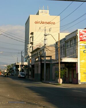
Kingston plays a central role in Jamaica's economy. The vast majority of economic activity takes place within Kingston, and as most government ministries are located in the city, it is a key force in legislation in regards to Jamaica's finances. The high population density of the capital city means that the majority of monetary transactions occur in Kingston – stimulating much of Jamaica's local economy. The city is also home to the highest number of schools, hospitals and universities anywhere in Jamaica. Kingston is also the island's main transportation hub[26] and its largest seaport.[27]
Many multinational conglomerates and financial institutions are headquartered in and around the Kingston Metropolitan Area. Air Jamaica was headquartered in Kingston.[28] The idea of making Jamaica an International Financial Centre has also been proposed as a way to boost the city's financial sector and create more jobs, especially for professionals such as accountants and lawyers.[29]
The city's major industries include tourism, apparel manufacturing, and shipping. Many international exports are traded through the city's seaport, with major exports including bauxite, sugar and coffee.[26] The city is also a major tourist destination, and tourism is one of its largest sources of economic activity.[30] The city has suffered economic troubles recently, however, along with the rest of the country of Jamaica.[31] Plans to help the city's economy have made downtown Kingston the subject of numerous redevelopment plans.[26] There have also been attempts to grow the manufacturing industry in the area and to attract call centres to the city.[31]
الجغرافيا
Kingston is surrounded by the Blue Mountains, Red Hills, Long Mountain and the Kingston Harbour, which is the seventh largest natural harbour in the world.[32] The city is on the Liguanea plain, an alluvial plain alongside the Hope River. Kingston experiences frequent earthquakes, including the 1907 earthquake.[9]
Kingston has a tropical climate, specifically a tropical wet-and-dry climate (Aw/As), that borders on a hot semi-arid climate (BSh). characterised by a wet season from May to November, which coincides with the hurricane season, and a dry season from December to April. During the dry season, there is not much rainfall, however, cold and stationary fronts occur at this time, and often bring heavy showers, especially in March. Kingston is in the rain shadow of the Blue Mountains; therefore, little to none of the moisture carried by the Northeast Trade Winds falls over Kingston, causing Kingston to be very dry in comparison to Portland and Saint Mary on the windward side of the Blue Mountains. Kingston is on a coastal location, hence it comes under the influence of the sea, though dense urban development can negate this effect. In the 21st century, Kingston has experienced temperatures as high as 38.8 °C (102 °F) and as low as 13.4 °C (56 °F). Between 1895 and 1990, the total average rainfall was recorded at 813 mm (32.0 in), the highest monthly average rainfall recorded in October at 177 mm (7.0 in), and the lowest monthly average rainfall recorded in March at 18 mm (0.71 in).[33] Fog, hail, thunder and tornadoes are all extremely rare.[34]
| متوسطات الطقس لKingston | |||||||||||||
|---|---|---|---|---|---|---|---|---|---|---|---|---|---|
| شهر | يناير | فبراير | مارس | أبريل | مايو | يونيو | يوليو | أغسطس | سبتمبر | اكتوبر | نوفمبر | ديسمبر | السنة |
| العظمى القياسية °C (°F) | 34 (93) | 33 (91) | 34 (93) | 34 (93) | 34 (93) | 35 (95) | 36 (97) | 36 (97) | 36 (97) | 36 (97) | 36 (97) | 36 (97) | 36 (97) |
| متوسط العظمى °م (°ف) | 30 (86) | 30 (86) | 30 (86) | 31 (88) | 31 (88) | 32 (90) | 32 (90) | 32 (90) | 32 (90) | 31 (88) | 31 (88) | 31 (88) | 31 (88) |
| متوسط الصغرى °م (°ف) | 19 (66) | 19 (66) | 20 (68) | 21 (70) | 22 (72) | 23 (73) | 23 (73) | 23 (73) | 23 (73) | 23 (73) | 22 (72) | 21 (70) | 22 (72) |
| الصغرى القياسية °م (°F) | 14 (57) | 15 (59) | 14 (57) | 17 (63) | 19 (66) | 20 (68) | 19 (66) | 20 (68) | 20 (68) | 18 (64) | 17 (63) | 14 (57) | 14 (57) |
| هطول الأمطار mm (بوصة) | 23 (0.9) | 15 (0.6) | 23 (0.9) | 31 (1.2) | 102 (4) | 89 (3.5) | 89 (3.5) | 91 (3.6) | 99 (3.9) | 180 (7.1) | 74 (2.9) | 36 (1.4) | 852 (33٫5) |
| المصدر: BBC Weather [35] 2009-12-18 | |||||||||||||
. . . . . . . . . . . . . . . . . . . . . . . . . . . . . . . . . . . . . . . . . . . . . . . . . . . . . . . . . . . . . . . . . . . . . . . . . . . . . . . . . . . . . . . . . . . . . . . . . . . . . . . . . . . . . . . . . . . . . . . . . . . . . . . . . . . . . . . . . . . . . . . . . . . . . . . . . . . . . . . . . . . . . . . .
مدن شقيقة
Kingston has five sister cities:
 Miami, Florida, الولايات المتحدة
 Kalamazoo, Michigan, الولايات المتحدة
 Coventry, إنگلترة, المملكة المتحدة
 Guadalajara, Mexico
 Shenzhen, الصين
الهامش
- ^ KSAC lauds contribution of century-old churches downtown
- ^ أ ب "Population usually resident in Jamaica by parish":2011". Statistical Institute of Jamaica. Retrieved 16 October 2015.
- ^ "Five Things You Didn't Know About Kingston, Jamaica". Caribbean Journal (in الإنجليزية). 2016-07-17. Retrieved 2022-06-21.
- ^ "Brief history of Kingston, Jamaica". Archived from the original on 3 March 2016.
- ^ "Electoral Commission of Jamaica". Archived from the original on 5 January 2012. Retrieved 30 June 2012.
- ^ "University of Texas, Perry–Castañeda Library Map Collection". Archived from the original on 15 January 2020. Retrieved 30 June 2012.
- ^ "Map of Kingston Jamaica – Jamaica's Capital City". Jamaica Land We Love. Retrieved 2022-06-21.
- ^ "Parish Profile: Kingston – Jamaica Information Service". jis.gov.jm. Retrieved 2022-06-21.
- ^ أ ب ت ث ج ح "Kingston | national capital, Jamaica". britannica.com (in الإنجليزية). Retrieved 2022-06-21.
- ^ أ ب ت Greene, Jack (2016). Settler Jamaica in the 1750s. University of Virginia Press. p. 153.
- ^ أ ب Mann, Emily. "Kingston, Jamaica – a city born of 'wickedness' and disaster". The Guardian. Retrieved 24 March 2016.
- ^ أ ب ت "Wolmers's Boys School". wolmers.net. Archived from the original on 15 February 2018. Retrieved 20 June 2017.
- ^ أ ب ت Christer Petley, White Fury (Oxford: Oxford University Press, 2018), p. 38.
- ^ "1882". Jamaica's history (in الإنجليزية). Retrieved 2022-06-21.
- ^ "Through the Years". jpsco.com. Archived from the original on Mar 10, 2022. Retrieved 30 April 2022.
- ^ أ ب "1907 Kingston Earthquake | EKACDM". uwi.edu. The University of the West Indies. Retrieved 2022-06-21.
- ^ Hart, Richard (2002). "Labour rebellions of the 1930s in the British Caribbean region colonies". libcom.org (in الإنجليزية). Retrieved 2022-06-21.
- ^ "Kingston 1966". thecgf.com (in الإنجليزية). Commonwealth Games Federation. Archived from the original on Jun 21, 2022. Retrieved 2022-06-21.
- ^ "The 1980s Historian | Memories of turbulent and volatile Jamaica". Jamaica Gleaner (in الإنجليزية). 2020-11-15. Retrieved 2022-06-21.
- ^ أ ب ت "Jamaica profile - Timeline". BBC News (in الإنجليزية البريطانية). 2018-01-10. Retrieved 2022-06-21.
- ^ Whittell, Giles (27 May 2010). "Jamaican leader denies link to Shower Posse gangsters". The Times. Retrieved 27 May 2010.
- ^ أ ب Sheil, Ross; Davies, Caroline (26 May 2010). "Kingston residents trapped inside homes as Jamaican death toll rises". The Guardian. Archived from the original on 27 May 2010. Retrieved 26 May 2010.
- ^ "Jamaica police put death toll at 73". The Gazette (Montreal). 27 مايو 2010. Archived from the original on 30 مايو 2010. Retrieved 27 مايو 2010.
- ^ "Synagogue and Heritage Centre". Archived from the original on 28 July 2011. Retrieved 30 June 2011. Site of the United Congregation of Israelites in Jamaica
- ^ "Jamaica: Facts and Statistics", Church News, 2020. Retrieved on 25 March 2020.
- ^ أ ب ت "Kingston & St.Andrew Economy". Archived from the original on 14 ديسمبر 2012. Retrieved 5 ديسمبر 2012.
- ^ Jackson, Steven. "Port of Kingston now the seventh busiest in Americas". Jamaica Observer. Archived from the original on 16 October 2018. Retrieved 2018-10-16.
- ^ "Contact Us Web Form." Air Jamaica. Retrieved on 5 August 2009. Archived 8 يوليو 2009 at the Portuguese Web Archive
- ^ Henry, Balford (6 August 2016). "Shaw resumes battle to make Jamaica an International Financial Centre". Jamaica Observer. Archived from the original on 10 August 2017. Retrieved 10 May 2017.
- ^ Kiprop, Joseph (16 May 2018). "The Biggest Industries in Jamaica". Worldatlas.com.
- ^ أ ب Davis, Nicholas (27 April 2012). "Jamaica struggles toward a sound economic future". BBC News. Retrieved 10 May 2017.
- ^ Burton, Morgan (2024-01-19). "What is the 7th largest natural harbor in the world?". Geographic FAQ Hub: Answers to Your Global Questions (in الإنجليزية الأمريكية). Retrieved 2024-01-23.
- ^ خطأ استشهاد: وسم
<ref>غير صحيح؛ لا نص تم توفيره للمراجع المسماةclimate - ^ VoodooSkies.com. "Voodoo Skies – Kingston Monthly Climate weather history".
- ^ "Average Conditions Kingston, Jamaica". BBC Weather. Retrieved December 18 2009.
{{cite web}}: Check date values in:|accessdate=(help); Unknown parameter|dateformat=ignored (help)
وصلات خارجية
- Jamaica Library Service: brief history of Kingston
- 2001 Census
- History
- Ministry of Health
- Jamaica National Heritage Trust
- The Tramways of Kingston, Jamaica
- FallingRain Map - elevation = 53m (Red dots are railways)

|
مونا، جاميكا |
| |||||
| سپانيش تاون | |||||||
- Pages using gadget WikiMiniAtlas
- مقالات ينقصها مصادر موثوقة
- مقالات ينقصها مصادر موثوقة from December 2022
- CS1 الإنجليزية البريطانية-language sources (en-gb)
- Webarchive template other archives
- CS1 الإنجليزية الأمريكية-language sources (en-us)
- CS1 errors: unsupported parameter
- Short description is different from Wikidata
- Coordinates on Wikidata
- Pages with empty portal template
- Host cities of the Commonwealth Games
- عواصم في الكاريبي
- عواصم أمريكا الشمالية
- مستوطنات ساحلية في جاميكا
- مدن وبلدات وقرى في جاميكا
- Settlements established in 1692
- موانئ في الكاريبي
- Kingston, Jamaica
