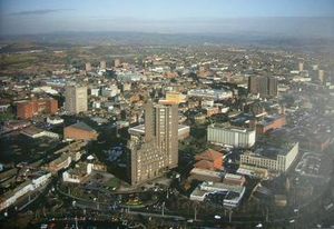
ستوك أون ترنت
ستوك-اون-ترنت | |
|---|---|
City and Unitary Authority area | |
 (top to bottom, left to right) Stoke-on-Trent Sixth Form College, Bottle kilns in Longton, Regent Theatre, Hanley skyline, Longton town hall Bethesda Methodist chapel | |
| الكنية: "Stoke", "The Potteries", "the city of five towns" | |
| الشعار: Vis Unita Fortior (united strength is stronger) | |
 Stoke-on-Trent shown within England and Staffordshire | |
| البلد | المملكة المتحدة |
| البلد المكون | إنگلترة |
| المنطقة | غرب ميدلاندز |
| Ceremonial county | ستافوردشاير |
| Admin HQ | ستوك-اپون-ترنت |
| أشهرت | 1910 |
| Granted City Status | 1925 |
| Granted Independent City Status | 1997 |
| السمِيْ | Component town Stoke-upon-Trent |
| الحكومة | |
| • النوع | مدينة Unitary |
| • العمدة اللورد | Jean Bowers |
| • Leader of the City Council | Ross Irving |
| • Leader | David Conway (City Independents) |
| • MPs | Gareth Snell (L) Ruth Smeeth (L) Jack Brereton (C) |
| المساحة | |
| • City and Unitary Authority area | 92٫74 كم² (35٫81 ميل²) |
| أعلى منسوب | 213 m (700 ft) |
| أوطى منسوب | 110 m (350 ft) |
| التعداد (2008 تق.)[6] | |
| • City and Unitary Authority area | 248٬700 |
| • الترتيب | 60th |
| • الكثافة | 2٬661/km2 (6٬890/sq mi) |
| • Urban | 372٬775 (19th) |
| • الكثافة الحضرية | 3٬588/km2 (9٬290/sq mi) |
| • العمرانية | 678٬000 (18th) |
| • Ethnicity | 88٫7% White 7٫4% Asian 1٫4% Black 1٫8% Mixed Race 0٫7% Other[4] |
| • Religion | 60٫9% Christian 6٫0% Muslim 1٫5% Other 31٫6% None/Not stated[5] |
| منطقة التوقيت | UTC±0 (Greenwich Mean Time) |
| • الصيف (التوقيت الصيفي) | UTC+1 (British Summer Time) |
| Postcode area | |
| Dialling code | 01782 |
| ISO 3166 code | GB-STE |
| Vehicle registration prefix | D |
| GSS code | E06000021 |
| NUTS 3 code | UKG23 |
| Trunk primary routes | A50 A500 |
| Major railway stations | Stoke-on-Trent (C1) |
| الموقع الإلكتروني | www |
ستوك-اون-ترنت Stoke-on-Trent مدينة في غربي وسط إنجلترا، ومركز صناعة الخزف في بريطانيا. عدد سكانها 248,700 نسمة. وهي منطقة حكم محلي. وتقع على نهر ترنت في ستافوردشاير على بعد حوالي 56 كم جنوبي مانشستر.
أدخل جوزياه ودجوود صناعة الخزف التجارية إلى ستوك في القرن الثامن عشر الميلادي. من بين الرجال الآخرين الذين ارتبطوا بصناعة الخزف في ستوك: وليام تيلر كوبلاند، وثوماس مينتون، وجوزياه سپود. وقصة المدينة الخيالية نيب في روايات أرنولد بنيت عن المدن الخمس مستوحاة من ستوك. وتصل قناة نهري ترنت وميرسي بين ستوك ومانشستر وليفربول.
. . . . . . . . . . . . . . . . . . . . . . . . . . . . . . . . . . . . . . . . . . . . . . . . . . . . . . . . . . . . . . . . . . . . . . . . . . . . . . . . . . . . . . . . . . . . . . . . . . . . . . . . . . . . . . . . . . . . . . . . . . . . . . . . . . . . . . . . . . . . . . . . . . . . . . . . . . . . . . . . . . . . . . . .
الديمغرافيا
| 2011 United Kingdom Census[8] | |
|---|---|
| Country of birth | Population |
| 228,294 | |
| 1,801 | |
| 693 | |
| 571 | |
| 324 | |
| 323 | |
| 257 | |
| 154 | |
| 150 | |
| 125 | |
| 122 | |
| 101 | |
| 91 | |
| 71 | |
المناخ
The absolute minimum temperature stands at −13.3 °C (8.1 °F),[9] recorded during January 1963. In an average year, a total of 48.3 air frosts will be registered.
Rainfall averages around 806 mm a year.[10]
| Climate data for Stoke on Trent / Keele, elevation: 179m, (1981–2010) extremes (1960–present) | |||||||||||||
|---|---|---|---|---|---|---|---|---|---|---|---|---|---|
| Month | Jan | Feb | Mar | Apr | May | Jun | Jul | Aug | Sep | Oct | Nov | Dec | Year |
| Record high °C (°F) | 13.3 (55.9) |
15.4 (59.7) |
20.6 (69.1) |
23.7 (74.7) |
25.9 (78.6) |
32.5 (90.5) |
31.3 (88.3) |
32.9 (91.2) |
26.5 (79.7) |
26.8 (80.2) |
17.3 (63.1) |
14.4 (57.9) |
32.9 (91.2) |
| Mean daily maximum °C (°F) | 6.2 (43.2) |
6.6 (43.9) |
9.1 (48.4) |
11.8 (53.2) |
15.1 (59.2) |
17.7 (63.9) |
20.3 (68.5) |
19.7 (67.5) |
16.9 (62.4) |
13.0 (55.4) |
9.0 (48.2) |
6.4 (43.5) |
12.6 (54.7) |
| Daily mean °C (°F) | 3.7 (38.7) |
3.8 (38.8) |
5.9 (42.6) |
7.9 (46.2) |
11.0 (51.8) |
13.7 (56.7) |
15.8 (60.4) |
15.7 (60.3) |
13.3 (55.9) |
9.9 (49.8) |
6.5 (43.7) |
3.9 (39.0) |
9.3 (48.7) |
| Mean daily minimum °C (°F) | 1.1 (34.0) |
0.9 (33.6) |
2.6 (36.7) |
4.0 (39.2) |
6.9 (44.4) |
9.6 (49.3) |
11.7 (53.1) |
11.6 (52.9) |
9.7 (49.5) |
6.8 (44.2) |
3.7 (38.7) |
1.4 (34.5) |
5.9 (42.6) |
| Record low °C (°F) | −13.3 (8.1) |
−10.0 (14.0) |
−9.4 (15.1) |
−4.7 (23.5) |
−2.8 (27.0) |
1.4 (34.5) |
5.0 (41.0) |
4.6 (40.3) |
1.1 (34.0) |
−2.5 (27.5) |
−7.0 (19.4) |
−12.5 (9.5) |
−13.3 (8.1) |
| Average precipitation mm (inches) | 67.9 (2.67) |
48.3 (1.90) |
58.5 (2.30) |
58.0 (2.28) |
62.7 (2.47) |
67.3 (2.65) |
62.1 (2.44) |
75.4 (2.97) |
69.1 (2.72) |
82.7 (3.26) |
76.7 (3.02) |
77.4 (3.05) |
806.1 (31.74) |
| Average precipitation days (≥ 1.0 mm) | 13.2 | 10.4 | 13.0 | 11.6 | 10.8 | 11.0 | 11.3 | 11.6 | 10.6 | 13.4 | 13.5 | 13.4 | 143.6 |
| Mean monthly sunshine hours | 52.6 | 71.7 | 100.4 | 143.9 | 182.0 | 159.4 | 178.5 | 167.1 | 123.4 | 100.2 | 58.1 | 45.5 | 1٬382٫9 |
| Source 1: KNMI[11] | |||||||||||||
| Source 2: Met Office[12] | |||||||||||||
انظر أيضاً
- Category:People from Stoke-on-Trent, for other people who were born in or had a significant contribution to Stoke-on-Trent.
- سپود (خزف)
- ستافوردشاير
الهامش
|
وصلات خارجية
- Creative Stoke creativestoke.org.uk
- Staffordshire and Stoke-on-Trent Archive Service staffordshire.gov.uk
- The Peoples Archive Chronicling the changing face of North Staffordshire
الإعلام المحليa
- Local Information from Pits n Pots on-line newspaper
- Local Information from The Sentinel newspaper
- Local Information from the BBC
- Pages using gadget WikiMiniAtlas
- Short description is different from Wikidata
- Pages using infobox settlement with possible nickname list
- Pages using infobox settlement with no coordinates
- Coordinates on Wikidata
- Articles including recorded pronunciations (UK English)
- Local government in Staffordshire
- Settlements established in 1910
- Staffordshire
- Stoke-on-Trent
- Unitary authorities of England
- Cities in the West Midlands (region)


