خط العرض 22° شمالاً

Line across the Earth
22°
خط العرض 22nd شمال
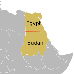
في أفريقيا, the parallel defines most of the border between Egypt and Sudan. The eastern part of the border is disputed.

خط العرض 22 شمالًا (إنگليزية: 22th parallel north) هي دائرة عرض بزاوية 22 درجة شمال خط الاستواء. تمر دائرة العرض 22° شمالاً عبر أفريقيا، المحيط الهندي، آسيا، المحيط الهادي، أمريكا الوسطى، منطقة البحر الكاريبي والمحيط الأطلسي.


تتبع غالبية الحدود بين مصر والسودان خط الموازي..[1]

عند خط العرض هذا، تكون الشمس مرئية لمدة 13 ساعة و29 دقيقة أثناء الانقلاب الصيفي، و10 ساعة و47 دقيقة أثناء الانقلاب الشتوي.[2]

. . . . . . . . . . . . . . . . . . . . . . . . . . . . . . . . . . . . . . . . . . . . . . . . . . . . . . . . . . . . . . . . . . . . . . . . . . . . . . . . . . . . . . . . . . . . . . . . . . . . . . . . . . . . . . . . . . . . . . . . . . . . . . . . . . . . . . . . . . . . . . . . . . . . . . . . . . . . . . . . . . . . . . . .

حول العالم

بدءاً من خط الزوال الرئيسي، في الاتجاه الشرقي، يمر خط العرض 22° شمالاً عبر:

الإحداثيات البلد أو الإقليم أو البحر ملاحظات
22°0′N 0°0′E / 22.000°N 0.000°E / 22.000; 0.000 (Prime Meridian) الجزائر الجزائر
22°0′N 9°21′E / 22.000°N 9.350°E / 22.000; 9.350 (Niger) نيجر نيجر
22°0′N 15°11′E / 22.000°N 15.183°E / 22.000; 15.183 (Chad) تشاد تشاد
22°0′N 19°4′E / 22.000°N 19.067°E / 22.000; 19.067 (Libya) Flag of Libya.svg ليبيا
22°0′N 25°0′E / 22.000°N 25.000°E / 22.000; 25.000 (Egypt / Sudan border) Flag of Egypt.svg مصر / السودان السودان border
22°0′N 31°19′E / 22.000°N 31.317°E / 22.000; 31.317 (Sudan) السودان السودان The border diverts north at Lake Nasser, enclosing the Wadi Halfa Salient - as it passes through the lake, the parallel is entirely within Sudan
22°0′N 31°24′E / 22.000°N 31.400°E / 22.000; 31.400 (Egypt / Sudan border) Flag of Egypt.svg مصر / السودان السودان border
22°0′N 33°10′E / 22.000°N 33.167°E / 22.000; 33.167 (Egypt / Bir Tawil border) Flag of Egypt.svg مصر / Bir Tawil border Bir Tawil is not claimed by any country.
22°0′N 34°5′E / 22.000°N 34.083°E / 22.000; 34.083 (Hala'ib Triangle / Sudan border) Hala'ib Triangle / السودان السودان border The Hala'ib Triangle is a disputed territory claimed by both Egypt and Sudan - Egypt controls the territory.
22°0′N 36°52′E / 22.000°N 36.867°E / 22.000; 36.867 (Red Sea) Red Sea
22°0′N 38°56′E / 22.000°N 38.933°E / 22.000; 38.933 (Saudi Arabia) Flag of Saudi Arabia.svg السعودية
22°0′N 55°40′E / 22.000°N 55.667°E / 22.000; 55.667 (Oman) عُمان عُمان
22°0′N 59°39′E / 22.000°N 59.650°E / 22.000; 59.650 (Indian Ocean) Indian Ocean Arabian Sea
22°0′N 69°10′E / 22.000°N 69.167°E / 22.000; 69.167 (India) Flag of India.png الهند Gujarat - Kathiawar Peninsula
22°0′N 72°14′E / 22.000°N 72.233°E / 22.000; 72.233 (Indian Ocean) Indian Ocean Gulf of Khambhat
22°0′N 72°30′E / 22.000°N 72.500°E / 22.000; 72.500 (India) Flag of India.png الهند Gujarat
Madhya Pradesh
Chhattisgarh
Orissa
West Bengal
22°0′N 89°5′E / 22.000°N 89.083°E / 22.000; 89.083 (Bangladesh) بنگلادش بنگلادش Several islands in the Ganges Delta
22°0′N 90°41′E / 22.000°N 90.683°E / 22.000; 90.683 (Indian Ocean) Indian Ocean Bay of Bengal
22°0′N 91°53′E / 22.000°N 91.883°E / 22.000; 91.883 (Bangladesh) بنگلادش بنگلادش
22°0′N 92°36′E / 22.000°N 92.600°E / 22.000; 92.600 (India) Flag of India.png الهند For about 3 km
22°0′N 92°38′E / 22.000°N 92.633°E / 22.000; 92.633 (Myanmar) Flag of Myanmar.svg ميانمار (Burma)
22°0′N 92°53′E / 22.000°N 92.883°E / 22.000; 92.883 (India) Flag of India.png الهند For about 4 km
22°0′N 92°56′E / 22.000°N 92.933°E / 22.000; 92.933 (Myanmar) Flag of Myanmar.svg ميانمار (Burma) For about 5 km
22°0′N 92°58′E / 22.000°N 92.967°E / 22.000; 92.967 (India) Flag of India.png الهند For about 3 km
22°0′N 93°0′E / 22.000°N 93.000°E / 22.000; 93.000 (Myanmar) Flag of Myanmar.svg ميانمار (Burma)
22°0′N 99°59′E / 22.000°N 99.983°E / 22.000; 99.983 (China) Flag of the People's Republic of China.svg الصين Yunnan - passing just north of Jinghong, Xishuangbanna Dai Autonomous Prefecture
22°0′N 101°37′E / 22.000°N 101.617°E / 22.000; 101.617 (Laos) Flag of Laos.svg لاوس
22°0′N 102°29′E / 22.000°N 102.483°E / 22.000; 102.483 (Vietnam) Flag of Vietnam.svg ڤيتنام
22°0′N 106°41′E / 22.000°N 106.683°E / 22.000; 106.683 (China) Flag of the People's Republic of China.svg الصين Guangxi (for about 4 km)
22°0′N 106°44′E / 22.000°N 106.733°E / 22.000; 106.733 (Vietnam) Flag of Vietnam.svg ڤيتنام For about 6 km
22°0′N 106°48′E / 22.000°N 106.800°E / 22.000; 106.800 (China) Flag of the People's Republic of China.svg الصين Guangxi and Guangdong
22°0′N 113°22′E / 22.000°N 113.367°E / 22.000; 113.367 (South China Sea) South China Sea
22°0′N 113°44′E / 22.000°N 113.733°E / 22.000; 113.733 (China)  مكاو Passing through islands in the Wanshan Archipelago (Guangdong), about 12 km south of Macau
22°0′N 113°50′E / 22.000°N 113.833°E / 22.000; 113.833 (South China Sea) South China Sea
22°0′N 114°8′E / 22.000°N 114.133°E / 22.000; 114.133 (China) Flag of Hong Kong.svg هونگ كونگ More islands in the Wanshan Archipelago (Guangdong), about 20 km south of Hong Kong
22°0′N 114°13′E / 22.000°N 114.217°E / 22.000; 114.217 (South China Sea) South China Sea
22°0′N 120°41′E / 22.000°N 120.683°E / 22.000; 120.683 (Taiwan)  تايوان
(Taiwan)
Passing through Hengchun and Kenting
22°0′N 120°52′E / 22.000°N 120.867°E / 22.000; 120.867 (Pacific Ocean) Pacific Ocean Passing just south of Orchid Island,  تايوان
22°0′N 160°6′W / 22.000°N 160.100°W / 22.000; -160.100 (United States)  الولايات المتحدة Island of Niihau, Hawaii
22°0′N 160°3′W / 22.000°N 160.050°W / 22.000; -160.050 (Pacific Ocean) Pacific Ocean
22°0′N 159°46′W / 22.000°N 159.767°W / 22.000; -159.767 (United States)  الولايات المتحدة Island of Kauai, Hawaii - passing just north of Lihue
22°0′N 159°21′W / 22.000°N 159.350°W / 22.000; -159.350 (Pacific Ocean) Pacific Ocean Passing just north of the island of San Juanito, Flag of Mexico.svg المكسيك
22°0′N 105°39′W / 22.000°N 105.650°W / 22.000; -105.650 (Mexico) Flag of Mexico.svg المكسيك Passing 8 km north of Aguascalientes
22°0′N 97°43′W / 22.000°N 97.717°W / 22.000; -97.717 (Gulf of Mexico) Gulf of Mexico
22°0′N 84°36′W / 22.000°N 84.600°W / 22.000; -84.600 (Cuba)  كوبا
22°0′N 84°0′W / 22.000°N 84.000°W / 22.000; -84.000 (Caribbean Sea) Caribbean Sea Gulf of Batabanó - passing just north of Isla de la Juventud,  كوبا
Gulf of Cazones - passing just south of the Zapata Peninsula,  كوبا
22°0′N 80°23′W / 22.000°N 80.383°W / 22.000; -80.383 (Cuba)  كوبا Passing 3 km north of Sancti Spíritus
22°0′N 77°38′W / 22.000°N 77.633°W / 22.000; -77.633 (Atlantic Ocean) Atlantic Ocean Passing between islands of the Flag of the Bahamas.svg البهاما
Passing just north of North Caicos,  جزر تركس وكايكوس
22°0′N 16°52′W / 22.000°N 16.867°W / 22.000; -16.867 (Western Sahara) Western Sahara Claimed by المملكة المغربية المملكة المغربية
22°0′N 13°4′W / 22.000°N 13.067°W / 22.000; -13.067 (Mauritania) موريتانيا موريتانيا
22°0′N 6°13′W / 22.000°N 6.217°W / 22.000; -6.217 (Mali) Flag of Mali.svg مالي
22°0′N 0°9′W / 22.000°N 0.150°W / 22.000; -0.150 (Algeria) الجزائر الجزائر


انظر أيضاً


المصادر

  1. ^ Brownlie, Ian (1979). African Boundaries: A Legal and Diplomatic Encyclopedia. Institute for International Affairs, Hurst and Co. pp. 110–20.
  2. ^ "Duration of Daylight/Darkness Table for One Year". U.S. Naval Observatory. 2019-09-24. Archived from the original on 2019-10-12. Retrieved 2021-03-10.