جيولوجيا سوريا
The geology of Syria includes ancient metamorphic rocks from the Precambrian belonging to the Arabian Craton, as well as numerous marine sedimentary rocks and some erupted basalt up to recent times. [1] [2]
. . . . . . . . . . . . . . . . . . . . . . . . . . . . . . . . . . . . . . . . . . . . . . . . . . . . . . . . . . . . . . . . . . . . . . . . . . . . . . . . . . . . . . . . . . . . . . . . . . . . . . . . . . . . . . . . . . . . . . . . . . . . . . . . . . . . . . . . . . . . . . . . . . . . . . . . . . . . . . . . . . . . . . . .
Geologic history, stratigraphy and tectonics
The oldest rocks in Syria are amphibolite, marble and amphibolite schist from the Precambrian which outcrop on the surface across much of the south. Carboniferous rocks from the Paleozoic appear in the north, in the vicinity of Hakem and El-Gharb.
Mesozoic (251-66 million years ago)
In the Mesozoic, an ophiolite zone with serptenized peridotite, diabase, spilite, pillow lava, tuff, argillite and radiolarite formed in the north and is present in northern Latakia close to the Turkish border.
Mesozoic rocks tend to be more numerous in the region, such as Jurassic limestone, marl, anhydrite and gypsum common in the west. Basalt at the base marks the beginning of the Cretaceous, ascending into clay, limestone, sandstone and dolomite from the Turonian and Cenomanian. Campanian are marked by detrital limestone with flint interbeds and chalk, while chalky limestone and marl are characteristic of the Maastrichtian.
Cenozoic (66 million years ago-present)
At the beginning of the Cenozoic, chalk, limestone, marl and clay deposition continued through the Paleocene and Eocene. The Oligocene brought a shift to sandstone and limestone. In the early Miocene, conglomerates became more common and quartz sands of continental origin appeared in the Palmyrides mountain belt. Some basalts erupted during the Helvetian.
The Tortonian has limestone, marl and conglomerate in the northwest and similar units plus clay, salt, and gypsum in the Al-Furat Basin. Basalt, tuff, breccia, limestone, clay, sandstone and conglomerate were common from the Pliocene, overlain by alluvial conglomerate, basalt and flood plain deposits from the Quaternary.
عمق الركيزة الجيولوجية في سورية
استخدمت في سورية معطيات المسح السيزمي (الاهتزازي) الانكساري عالية الدقة لتحديد عمق الركيزة، لأن سطح الركيزة المتحولة لا يشكل عاكساً واضحاً على سجلات المسح السيزمي الانعكاسي. وتم ربط المعلومات السيزمية مع الآبار العميقة عن طريق تنفيذ سجلات جيوفيزيائية بئرية، كما استخدمت نمذجة تقانة تتبع الأشعة لاشتقاق سرعة كل ما تحت الخطوط الانكسارية.[3]
وأدت إجراءات النمذجة المتكاملة والفعالة إلى وضع نموذج سرعة يتطابق مع كل المعلومات المتوافرة، وتبيّن أن الركيزة البلورية في سورية تقع، عامة، على عمق، يزيد على 6كم. كما أنه لم يتم اختراقها عن طريق الآبار العميقة المحفورة ولا تشكل عاكساً سيزمياً جيداً، لذلك تم تحديد عمق الركيزة باستخدام المسح الانكساري والمسح الثقالي.
وأكدت النتائج صحة الفرضيات التي تعدّ أن سورية، مثل بقية الصفيحة العربية، قد تكوّنت في أثناء دمج «تملغم» حدث في حقب البروتروزوي (انظر الحقب ما قبل الكمبري) منذ نحو 640-950 مليون سنة. وقد تركت هذه الصفائح سلسلةً من الدروز sutures ونطاقات القص التي نشطت كنطاقات ضعف في الفانروزوي (انظر الحقب الأول). ويمكن أن يشير الاختلاف في أعماق الركيزة وسماكات القشرة والكثافة على جانبي السلسلة التدمرية إلى أن شمالي سورية وجنوبيها مؤلف من صفائح صغيرة مختلفة تفصلها دروز، يمتد أحدها على طول اتجاه السلسلة التدمرية. ويشير هذا الاختلاف كذلك إلى أن صدع الجهار وسط السلسلة التدمرية هو واحد من الظواهر التركيبية الرئيسية في المنطقة. فإذا أُخذت هذه الملاحظات في الحسبان فإن القشرة المشكلة لنهوض الرطبة - الروضة تكون ذات صلة بالقشرة المسيطرة المشوهة لجنوب غربي السلسلة التدمرية، بينما تستمر القشرة تحت هضبة حلب تحت جبل البلعاس والبِشْري، على شكل قشيرة سميكة تكتونية.
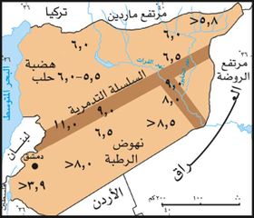
وقد توصَّل الدارسون، بعد ضم نتائج الدراسـات الجيوفيزيائية والبئرية، إلى وضع خارطة أعماق للركيزة الجيولوجية في سـورية (الـشكل-1)، تُظْهِر أن أكبر عمق للركيزة يقع تحت نطاقي التشوه للفرات وللطي التدمري. واقترح بعضهم أن هذه الاختلافات في عمق الركيزة قد تكون ناتجة من اختلاف أساسي في التاريخ الجيولوجي على جانبي الطي التدمري وحوض الفرات. وتمثل الاتجاهات التدمرية والفرات نطاق تدرز أو نطاق قص، التحمت على طوله شمال الصفيحة العربية في الحقب البروتروزوي المتأخر.
الهامش
- ^ Geological Map of Syria (Map). Ministry of Petroleum and Mineral Resources. 1986. Sheet 1.
- ^ "TECTONIC EVOLUTION OF SYRIA INTERPRETED FROM INTEGRATED GEOPHYSICAL AND GEOLOGICAL ANALYSIS" (PDF). Atlas.geo.cornell.edu. Retrieved 4 November 2018.
- ^ مظهر بايرلي. "الركيزة الجيولوجية". الموسوعة العربية.

