بيت أمر
بيت اُمّر | |
|---|---|
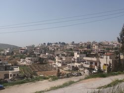
 بيت اُمّر عام 2011. | |
موقع بيت اُمّر في فلسطين | |
| الإحداثيات: 31°37′17″N 35°06′08″E / 31.62139°N 35.10222°E | |
| التربيع الفلسطيني | 159/114 |
| الدولة | فلسطين |
| المحافظة | الخليل |
| الحكومة | |
| • النوع | بلدية (من عام 1997) |
| • رئيس البلدية | نصري صبرانة |
| التعداد (2017)[1] | |
| • الإجمالي | 16٫977 |
| معنى الاسم | "بيت اُمّر"[2] |
بيت اُمّر أو بيت عمر (إنگليزية: Beit Ummar)، هي بلدة فلسطينية تقع على بعد 11 كيلومتر شمال غرب مدينة الخليل، محافظة الخليل، فلسطين.[3] بحسب الجهاز المركزي للاحصاء الفلسطيني، عام 2017، بلغ عدد سكان البلدة 16.977 نسمة.[1] أكثر من 4.800 من سكان البلدة تقل أعمارهم عن 18 عامًا. منذ الانتفاضة الثانية، تتراوح معدلات البطالة بين 60 و80 بالمائة ويرجع ذلك في الغالب إلى عدم قدرة السكان على العمل في إسرائيل والكساد في الاقتصاد الفلسطيني.[4] يقع جزء من المدينة على الطريق 60، ونتيجة لذلك، ظهرت عدة مقترحات لهدم المنازل.[5]
بيت أمر هي منطقة زراعية في الغالب وتشتهر بكثرة كروم العنب. وهذا له جانب رئيسي في تقاليده الطهي بالبلدة المتمثلة في ورق العنب المحشي وشراب العنب المسمى الدبس.[6]
التاريخ
بحسب المزاعم اليهودية، يعتقد بيت أمر هي موقع قرية معرة التوراتية.[6][7][8][9]
في الثلاثينيات، تم التنقيب عن كنيسة يعود تاريخها مبدئيًا إلى القرن الخامس الميلادي (لكن مع التغييرات التي ربما أجريت في القرن الثامن) في خربة عصيدة، شرق وسط بيت أمر.[10]
وبحسب بعض التقاليد، سميت المدينة باسم الخليفة عمر بن الخطاب لأنه من المفترض أنه كان يتردد على المدينة. العديد من سكان البلدة ذات الأغلبية المسلمة هم من نسل مسيحيين عرب الذين اعتنقوا الإسلام أثناء الفتح الإسلامي في القرن السابع. تشهد الآثار المسيحية في المدينة القديمة على هذا منذ أكثر من 1000 سنة.[5]
يضم المسجد الرئيسي في بيت أمر قبر النبي متى. ويشير متى إلى عميتان، والد النبي يونس. كتب مجير الدين أن متى كان "رجلاً مقدساً من أهل بيت النبوة". بالقرب من حلحول يوجد قبر يونان المزعوم مع نقش مكتوب عليه "يونس بن متى" أو "يونان بن عميتاي"، مما يؤكد أن متى هو بالفعل الاسم العربي لعميتاي (اقترح البعض أنه يشير إلى متى الرسول).[11][12]
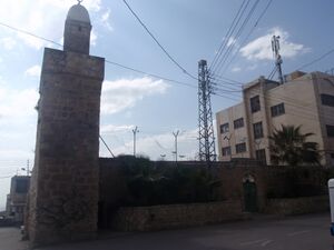
عام 1226 بنى السلطان الأيوبي المعظم مسجدًا به مئذنة بإشراف والي القدس رشيد الدين المعظمي. وقام المماليك ببعض الإضافات على المسجد ونقشوا على سطحه عدة نقوش.[11]
الفترة العثمانية
عام 1838، لاحظ إدوارد روبنسون القرية من الدوايمة.[13]
زار ڤيكتور گيران القرية عام 1863، فوجد أن عدد سكانها حوالي 450 نسمة.[14] كتب المستشرق السويسري ألبير سوسين، مشيرًا إلى قائمة القرى العثمانية الرسمية حوالي عام 1870، أن بيت أمر كان بها إجمالي 44 منزلًا ويبلغ عدد سكانها 133 نسمة، على الرغم من أن عدد السكان هذا يشمل الرجال فقط.[15] أشار هارتمان إلى أن بيت أمر بها 60 منزلاً.[16]
عام 1883، وصف مسح غرب فلسطين من قبل صندوق مسح فلسطين بيت أمر بأنها "قرية صغيرة لكن بارزةها تقف على مستجمع مياه، "ويمكن رؤيتها من مسافة ما في الشمال. ويمر عبرها طريق قديم. وعلى بعد نصف ميل إلى الشمال الشرقي توجد عين الخير عين كوفين. ويوجد للمسجد برج صغير بجانبه. والحي المحيط به مغطى بالأغصان".[17]
الانتداب البريطاني
في تعداد فلسطين 1922، الذي أجرته سلطات الانتداب البريطاني، كان عدد سكان بيت أمر 829 نسمة، جميعهم من المسلمين،[18] ارتفع عددهم في تعداد 1931 إلى 1.135، جميعهم مسلمين أيضاً، في 217 منزلاً مأهولاً.[19]
في 1945 كان عدد سكان بيت أمر 80 يهودياً و1600 مسلم، وتبلغ مساحة أراضيها الإجمالية 30.129 دونماً، حسب المسح الرسمي للأراضي والسكان.[20][21] 2.912 دونمًا عبارة عن مزارع وأراضي قابلة للري، و12.879 دونمًا مخصصة للحبوب،[22] في حين 55 دونماً من الأراضي المبنية (الحضرية).[23]
الحكم الأردني
في أعقاب حرب 1948، وبعد اتفاقيات الهدنة 1949، أصبحت بيت أمر تحت الحكم الأردني. وضمتها الأردن عام 1950.
عام 1961 كان عدد سكان بيت أمر 2.103 نسمة.[24]
1967-الحاضر
منذ حرب 1967، كانت بيت أمر تحت الاحتلال الإسرائيلي. عام 1967 بلغ عدد السكان في التعداد الذي أجرته سلطات الاحتلال 2.630 نسمة.[25]
أصبحت بيت أمر بلدية في 17 أبريل 1997، بعد حل المجلس القروي الإسرائيلي وتعيين حسين بدر من قبل السلطة الوطنية الفلسطينية.[5] عمدة بيت آمر الحالي هو نصري صبرانة.[26]
تقع البلدة حاليًا في المنطقة ب (الشؤون المدنية التي تديرها السلطة الوطنية الفلسطينية) والمنطقة ج (الشؤون المدنية والعسكرية التي تديرها إسرائيل).[5] استولت إسرائيل [27] أو صادرت[28] حوالي 4.000 دونماً من أراضي القرية من أجل بناء طرق دائرية إسرائيلية والعديد من المستوطنات الإسرائيلية: كرمي تصور، مگدال عوز، كفار عتصيون وإفرات.
البلدة تحت حكم مجلس بلدي يتكون من ثلاثة عشر عضوًا بما في ذلك رئيس البلدية.
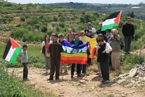
أثناء الاحتلال الإسرائيلي قُتل عدة أشخاص في القرية برصاص الجنود أو المستوطنين الإسرائيليين:
- في يناير 2011، قُتل يوسف خلايل البالغ من العمر 17 عاماً بالرصاص أثناء مشاجرة مع المستوطنين الإسرائيليين من بات عين.[29][30]
- في أغسطس 2014، قُتل 3 فلسطينيين في نفس اليوم برصاص قناص من الجيش الإسرائيلي أثناء مظاهرة محلية: عبد الحميد برجيت، 32 عامًا وأب لثلاثة أطفال، وسلطان زقيق، 29 عامًا، وأب لطفلين، وهاشم أبو ماريا. يبلغ من العمر 45 عامًا.[31] كان أبو ماريا يعمل في الحركة الدولية للدفاع عن الأطفال.[31][32]
- في أبريل 2015، قُتل زياد عوض، البالغ من العمر 27 عاماً، بالرصاص أثناء مظاهرة بدأت بعد جنازة ابن عمه.[33][34][35]
- في يوليو 2015، قُتل فلاح أبو ماريا، البالغ من العمر 52 عامًا، برصاص القوات الإسرائيلية.[36]
- في يوليو 2021، قُتل محمد العلمي، البالغ من العمر 12 عامًا، برصاص جندي إسرائيلي بينما كان يستقل سيارة مع والده وشقيقته.[37][38] وقُتل شوكت عوض، 22 عاماً، بالرصاص أثناء تشييع العلمي.[39][40]
أبرز السكان
المصادر
- ^ أ ب Preliminary Results of the Population, Housing and Establishments Census, 2017. State of Palestine. February 2018. pp. 64–82. Archived from the original. You must specify the date the archive was made using the
|archivedate=parameter. https://www.pcbs.gov.ps/Downloads/book2364-1.pdf. Retrieved on 2023-10-24. - ^ Palmer, 1881, p. 389
- ^ Beit Ummar: Town Statistics and Facts
- ^ Beit Omar Background
- ^ أ ب ت ث Sample Area Background: Beit Ummar Archived 2007-12-12 at the Wayback Machine (2000) Campaign for Secure Dwellings, Christian Peacemaker Teams
- ^ أ ب Beit Ummar: Where Dreams Come True Aging with Dignity in Palestinian Villages Qleibo, Ali. This Week in Palestine.
- ^ Armstrong, 1889, p.119
- ^ Hastings, James (2004) [1898]. A Dictionary of the Bible: Volume III: (Part II: O -- Pleiades) (reprint). Honolulu, Hawaii: University Press of the Pacific. p. 648. ISBN 978-1-4102-1727-1.
The ninth group is in the mountains north of Hebron, including Halhu (Halhul), Bethzur (Beit Sur), Maarath (Beit Umar), Beth-anoth (Beit Ainun), and Eltekon - perhaps Tekoa (Tekua).
- ^ Wilson, John (1847). The Lands of the Bible Visited and Described, Volume 1. Edenburgh: William Whyte. pp. 386 – 387. OL 20556861M.
Beit-Ummar is on a heights to the left. It is apparently a considerable village... At least four of these villages are thus given in juxtaposition in Joshua, "Halhul, Beth-Zur and Gedor and Maarath, and Beth-Anoth, and Eltekon."
- ^ Baramki and Avi-Yonah, 1934, pp. 17–19
- ^ أ ب Sharon, 1999, pp. 161-164
- ^ Clermont-Ganneau, 1899, p. 456
- ^ Robinson and Smith, 1841, vol2, p. 401
- ^ Guérin, 1869, p. 298
- ^ Socin, 1879, p. 145
- ^ Hartmann, 1883, p. 142
- ^ Conder and Kitchener, 1883, SWP III, p. 303
- ^ Barron, 1923, Table V, Sub-district of Hebron, p. 10
- ^ Mills, 1932, p. 27
- ^ Government of Palestine, Department of Statistics, 1945, p. 23
- ^ Government of Palestine, Department of Statistics. Village Statistics, April, 1945. Quoted in Hadawi, 1970, p. 50
- ^ Government of Palestine, Department of Statistics. Village Statistics, April, 1945. Quoted in Hadawi, 1970, p. 93
- ^ Government of Palestine, Department of Statistics. Village Statistics, April, 1945. Quoted in Hadawi, 1970, p. 143
- ^ Government of Jordan, Department of Statistics, 1964, p. 15
- ^ Perlmann, Joel (November 2011 – February 2012). "The 1967 Census of the West Bank and Gaza Strip: A Digitized Version" (PDF). Levy Economics Institute. Retrieved 24 June 2016.
- ^ Municipality Guide Nablus Municipality Official Website Archived ديسمبر 4, 2007 at the Wayback Machine
- ^ Beit Ummar Town Profile, ARIJ, pp. 15–16
- ^ Agencies, IMEMC News &. "Soldiers Invade Beit Ummar" (in الإنجليزية الأمريكية). Retrieved 2020-02-22.
- ^ "Palestinian killed in clashes with settlers near Hebron". The Jerusalem Post | JPost.com (in الإنجليزية الأمريكية). 2011-01-29. Retrieved 2023-11-26.
- ^ "Court releases hikers suspected of killing Palestinian teen". The Jerusalem Post (in الإنجليزية الأمريكية). 2011-02-03. Retrieved 2023-11-26.
- ^ أ ب "A Bullet Through the Heart of a Palestinian Man - and an Entire Community". Haaretz (in الإنجليزية). Retrieved 2023-11-26.
- ^ "Fresh West Bank clashes". Al Jazeera (in الإنجليزية). Retrieved 2023-11-26.
- ^ "27-year-old Palestinian killed near Hebron after funeral of his cousin". Middle East Eye (in الإنجليزية). Retrieved 2023-11-26.
- ^ "Palestinian killed in clashes with Israeli forces". AP News (in الإنجليزية). 2015-04-10. Retrieved 2023-11-26.
- ^ "Palestinians: One Killed, Six Wounded in Clashes With Israeli Forces". Haaretz (in الإنجليزية). Retrieved 2023-11-26.
- ^ Israeli Forces Shoot and Kill Palestinian During West Bank Raid, Diaa Hadid, July 23, 2015, The New York Times
- ^ "Israeli troops shoot dead 12-year-old Palestinian boy: Ministry". Al Jazeera (in الإنجليزية). Retrieved 2023-11-26.
- ^ "Beit Ommar: They killed his child and immediately took his working permit". Machsomwatch (in الإنجليزية). Retrieved 2023-11-26.
- ^ "Israeli forces kill young Palestinian man during funeral of 12-year-old boy". Middle East Eye (in الإنجليزية). Retrieved 2023-11-26.
- ^ Border Police raid home of Beit Ummar resident, order her to stand by them on roof while stones were thrown at them, and force her to carry military equipment, 14 September 2021, B'Tselem
المراجع
- Armstrong, George (1889). Names and Places in the Old and New Testament and Apocrypha. Committee of the Palestine Exploration Fund.
- Baramki, D.C.; Avi-Yonah, M. (1934). "An early Christian Church at Khirbat 'Asida". Quarterly of the Department of Antiquities in Palestine. 3: 17–19.
- Barron, J.B., ed. (1923). Palestine: Report and General Abstracts of the Census of 1922. Government of Palestine.
- Clermont-Ganneau, C.S. (1899). [ARP] Archaeological Researches in Palestine 1873-1874, translated from the French by J. McFarlane. Vol. 1. London: Palestine Exploration Fund.
- Conder, C.R.; Kitchener, H.H. (1883). The Survey of Western Palestine: Memoirs of the Topography, Orography, Hydrography, and Archaeology. Vol. 3. London: Committee of the Palestine Exploration Fund.
- Government of Jordan, Department of Statistics (1964). First Census of Population and Housing. Volume I: Final Tables; General Characteristics of the Population (PDF).
- Government of Palestine, Department of Statistics (1945). Village Statistics, April, 1945.
- Guérin, V. (1869). Description Géographique Historique et Archéologique de la Palestine. Vol 1; Judee, pt. 3.
- Hadawi, S. (1970). Village Statistics of 1945: A Classification of Land and Area ownership in Palestine. Palestine Liberation Organization Research Centre.
- Hartmann, M. (1883). "Die Ortschaftenliste des Liwa Jerusalem in dem türkischen Staatskalender für Syrien auf das Jahr 1288 der Flucht (1871)". Zeitschrift des Deutschen Palästina-Vereins. 6: 102–149.
- Hütteroth, Wolf-Dieter; Abdulfattah, Kamal (1977). Historical Geography of Palestine, Transjordan and Southern Syria in the Late 16th Century. Erlanger Geographische Arbeiten, Sonderband 5. Erlangen, Germany: Vorstand der Fränkischen Geographischen Gesellschaft. ISBN 978-3-920405-41-4.
- Mills, E., ed. (1932). Census of Palestine 1931. Population of Villages, Towns and Administrative Areas. Jerusalem: Government of Palestine.
- Palmer, E.H. (1881). The Survey of Western Palestine: Arabic and English Name Lists Collected During the Survey by Lieutenants Conder and Kitchener, R. E. Transliterated and Explained by E.H. Palmer. Committee of the Palestine Exploration Fund.
- Robinson, E.; Smith, E. (1841). Biblical Researches in Palestine, Mount Sinai and Arabia Petraea: A Journal of Travels in the year 1838. Vol. 2. Boston: Crocker & Brewster.
- Sharon, M. (1999). Corpus Inscriptionum Arabicarum Palaestinae, B-C. Vol. II. BRILL. ISBN 978-9004110830.
- Socin, A. (1879). "Alphabetisches Verzeichniss von Ortschaften des Paschalik Jerusalem". Zeitschrift des Deutschen Palästina-Vereins. 2: 135–163.
وصلات خارجية
- Welcome To Bayt Ummar
- Beit Ummar, Welcome to Palestine
- Survey of Western Palestine, Map 21: IAA, Wikimedia commons
- Beit Ummar Town (Fact Sheet), Applied Research Institute–Jerusalem (ARIJ)
- Beit Ummar Town Profile, (ARIJ)
- Beit Ummar aerial photo, (ARIJ)
- The priorities and needs for development in Beit Ummar town based on the community and local authorities’ assessment, (ARIJ)


