ألستر
Ulster
| |
|---|---|
 | |
| Sovereign states | United Kingdom Republic of Ireland |
| Counties | Antrim (UK) Armagh (UK) Cavan (ROI) Donegal (ROI) Down (UK) Fermanagh (UK) Londonderry (UK) Monaghan (ROI) Tyrone (UK) |
| الحكومة | |
| • MEPs[b] | 1 Sinn Féin MEP 2 Fine Gael MEPs 1 Independent MEP |
| • UK MPs and RoI TDs | 7 Sinn Féin MPs 5 DUP MPs 2 SDLP MPs 1 Alliance MP 1 UUP MP 1 TUV MP 1 Independent MP 4 Sinn Féin TDs 3 Fianna Fáil TDs 2 Fine Gael TDs 1 Independent TDs |
| • MLAs | 27 Sinn Féin MLAs 25 DUP MLAs 8 SDLP MLAs 9 UUP MLAs 17 Alliance MLAs 1 PBP MLA 1 TUV MLA 4 Independent MLAs [1] |
| • Councillors (NI) and Councillors (ROI) | 122 DUP Cllrs 105 Sinn Féin Cllrs 75 UUP Cllrs 59 SDLP Cllrs 53 Alliance Cllrs 8 Green Cllrs 6 TUV Cllrs 5 People Before Profit Cllrs 3 PUP Cllr 2 Aontú Cllr 1 CCLA Cllr 24 Independent Cllrs 24 Fianna Fáil Cllrs 17 Sinn Féin Cllrs 17 Fine Gael Cllrs 1 Labour Cllr 1 Aontú Cllr 13 Independent Cllrs |
| المساحة | |
| • الإجمالي | 22٬067 كم² (8٬520 ميل²) |
| ترتيب المساحة | 2nd |
| التعداد (2022 estimate[a]) | |
| • الإجمالي | 2٬217٬176 |
| • الترتيب | 2nd |
| • الكثافة | 100/km2 (260/sq mi) |
| منطقة التوقيت | UTC±0 (GMT/WET) |
| • الصيف (التوقيت الصيفي) | UTC+1 (BST/IST) |
| Postcodes | |
| Telephone area codes | Northern Ireland: 028 (from Great Britain) 048 (from Republic of Ireland) +44-28 (from rest of world) Donegal: +353-74 Cavan and Monaghan: +353-4x |
| ISO 3166 code | IE-U (Republic of Ireland) GB-NIR (Northern Ireland) |
| Patron Saints: Finnian of Moville[2] and Columba
a. ^ The Northern Ireland Statistics and Research Agency[3] census of 2021 results (1,903,100) combined with the preliminary results of 2022 census of Ireland for Ulster (part of; 314,076).[4] b. ^ The counties of Cavan, Monaghan and Donegal are part of the Midlands–North-West constituency (4 MEPs); these three counties contain 19.5% of the population of the constituency.[5] Following Brexit, as the United Kingdom left the EU, there are no MEPs from Northern Ireland. | |
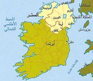
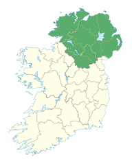
ألستر Ulster (أيرلندية: Ulaidh / Cúige Uladh، ألستر سكوتس: Ulstèr) هي واحدة من مقاطعات أيرلندا الأربع، وتقع في شمال الجزيرة. وتشمل تسعا من المقاطعات الاثنتين والثلاثين التي تتضمنها جزيرة أيرلندا بأكملها. وتتكون أيرلندا الشمالية من ست من مقاطعات ألستر التسع، وهي تعد جزءًا من المملكة المتحدة. وهذه المقاطعات الست هي أنتريم وأرما وداون وفرمانا ولندنديري وتايرون. أما المقاطعات الثلاث الأخرى ـ كافان ودونيجال وموناهان ـ فهي جزء من جمهورية أيرلندا. وأكبر مدينة في ألستر هي بلفاست.
السكان ونظام الحكم
تنحدر أغلبية سكان ألستر من أصول إنجليزية وأسكتلندية وأيرلندية قديمة، كما أن أغلبهم من البروتستانتيين الذين يكونون نحو ثلثي السكان في أيرلندا الشمالية. ومعظم البروتستانتيين يتبعون الكنيسة الأبرشية. وهناك جماعات نصرانيَّة أخرى منها أتباع الكنيسة الأيرلندية والميثودية. ويغلب على الثلث المتبقي من السكان الكاثوليكية الرومانية. أما في مقاطعات ألستر الثلاث الداخلة في حدود الجمهورية، فهناك تقريبـًا سبعة أشخاص من كل ثمانية يدينون بالكاثوليكية.
التقسيم الاداري
المقاطعات
| المقاطعة County | التعداد | المساحة |
|---|---|---|
| County Antrim (Aontroim) | 616,384 | 2,844 كم² |
| County Armagh (Ard Mhacha) | 126,803 | 1,254 كم² |
| County Cavan (an Cabhán) | 56,546 | 1,931 كم² |
| County Donegal (Dún na nGall) | 137,575 | 4,841 كم² |
| County Down (an Dún) | 410,487 | 2,448 كم² |
| County Fermanagh (Fear Manach) | 54,033 | 1,691 كم² |
| County Londonderry (Doire) | 211,669 | 2,074 كم² |
| County Monaghan (Muineachán) | 52,593 | 1,294 كم² |
| County Tyrone (Tír Eoghain) | 158,460 | 3,155 كم² |
| المجموع الإجمالي | 1,993,918 | 24,481 كم² |
Counties shaded in gray are in the Republic of Ireland.
أكبر التجمعات السكنية
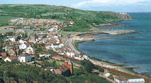
Settlements in Ulster with at least 25,000 inhabitants, listed in order of population:
- بلفاست (276,459)
- دري (83,652)
- ليسبرن (71,465)
- نيوتن آبي (62,056)
- Bangor (58,388)
- Craigavon Urban Area (57,685)
- Portadown (30,000)
- باليمنا (28,717)
- Newtownards (27,821)
- Newry (27,433)
- Carrickfergus (27,201)
- لورگان (25,000)
اللغات
والإنجليزية هي اللغة المتداولة في شمالي أيرلندا، إلا أن اللغة الأيرلندية تدرس في بعض مدارسها. وهناك منطقة كبيرة في الجزء الجمهوري من ألستر في غرب دونيجال يتحدث أهلها الأيرلندية الغيليَّة، ويبلغ سكان المنطقة 26,000 نسمة. كما أن الأيرلندية تدرس في شرقي دونيجال وفي كافان وموناهان أيضـًا.
الاقتصاد
تتركز الصناعة في شرقي ألستر أكثر من أي مكان آخر في المقاطعة، ولبناء السفن والكتان أهمية تقليدية منذ القدم، إلا أن النشاط الصناعي يشمل الآن صناعة الطائرات والمواد الغذائية والمشروبات وصناعات هندسية مختلفة، وصناعة الخزف والأحذية والمعدات الإلكترونية والأثاث، ومعدات التنقيب عن النفط في البحار والمعدات البصرية وأجهزة القياس والمنسوجات والقيشاني وإطارات السيارات. وتعد مدينة بلفاست مركزًا تجاريـًا رئيسيـًا كما أنها مركز لأنشطة الطباعة.
أما في غربي ألستر وجنوبها فتتركز معظم الصناعة في دونيجال التي تشتهر بصناعة نسيج التويد (وهو نسيج صوفي خشن) والسجاد. أما موناهان فتنتج الملابس والأثاث والأغذية المعلبة والمحولات الكهربائية ومنتجات الحديد والصلب.
ويهتم المزارعون في ألستر بزراعة الشعير والشوفان والبطاطس في حين أن الثروة الحيوانية المهمة تنحصر غالبـًا في الخنازير والدواجن والمواشي. وفي الجزء التابع للجمهورية، يهتم المزارعون أيضـًا بتربية الماشية، وتعد موناهان المركز الرئيسي في أيرلندا لإنتاج الدواجن، بينما تعد كيلي بجز ـ في دونيجال ـ ميناءً رئيسيـًا لصيد الأسماك.
ولموانىء ألستر الرئيسية ـ أي بلفاست ولارن ـ خطوط مواصلات بحرية تنقل المسافرين والبضائع وتربط الإقليم بالعديد من الموانىء في إنجلترا وأسكتلندا وأيضا مع ميناء هولي هد في ويلز. ويخدم مطار ألدرجروف الرحلات الجوية مع أوروبا والولايات المتحدة. أما الطرق البرية والسكك الحديدية داخل أيرلندا الشمالية وأيضـًا في بقية الإقليم، فتقوم بها هيئات تملكها الحكومة أو تدعمها.
السطح
يحد ألستر من الشرق والشمال الشرقي البحر الأيرلندي والقنال الشمالي، ومن الشمال والغرب المحيط الأطلسي بينما يحدها جنوبـًا محافظة كنوت من جهة الغرب ولاينستر من جهة الشرق. وتبلغ المسافة بين أطول نقطتين 174كم من الشمال إلى الجنوب و 214 كم من الغرب إلى الشرق.
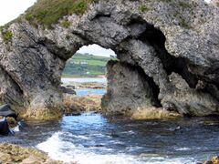
وتقع هضبة أنتريم في شمال شرقي ألستر، وهي تتكون من البازلت (الحمم البركانية الباردة) تقطعها وهاد تسمى جلنز أوف أنتريم تتجه شمالاً صوب البحر. وعلى ساحل أنتريم الشمالي، توجد أعمدة البازلت الجميلة التي تسمى جيانتس كوزوي أو ممر العمالقة. ويتكون ساحل أنتريم ولندنديري من الجبال وهضاب البازلت والصخور الجيرية، كما تكون الصخور الجيرية الطبقات القريبة تحت معظم مساحة فرمانا. أما دونيجال، ففيها جزء شمالي جبلي غير مستو ومنطقة أقل وعورة في الجنوب تكثر بها الشواطئ الممتدة. وتشكل جبال سبرين الحدود الفاصلة مابين لندنديري وتايرون، بينما تمتد جبال مورن في داون الجنوبية مشكلة سلسلة فاتنة (ساحرة) من القمم الجرانيتية حيث تبلغ أعلى قممها 848 م.
وتقع لونيا، وهي أكبر بحيرة في أيرلندا، في منخفض على هضبة أنتريم. وينبع نهر بان في جبال مورن ويمر عبر بحيرة لونيا ليصب عند ساحل أنتريم الشمالي، بينما يتجه نهر فويل إلى الشمال الشرقي من ليفورد في دونيجال ليصب في لوخ فويل وهو خليج صغير يفصل دونيجال عن لندنديري. أما نهر أيرن فيستوعب معظم مياه الأمطار في فرمانا وألستر الجنوبية ويمر عبر بحيرتين هما لوخ إيرن العليا ولوخ إيرن السفلى. أما نهر لاغان الذي تقوم عليه مدينة بلفاست، فهو ينبع من سلسلة تلال تسمى سليف كروب. وتفصل منطقة سترانجفورد لوخ، وهي خليج صغير تكثر بها الجزر الصغيرة، مابين شبه جزيرة آرد وأجزاء داون الأخرى.
الجغرافيا الطبيعية
The biggest lake in the British Isles, Lough Neagh, lies in eastern Ulster. The province's highest point, Slieve Donard (848 metres (2,782 ft)), stands in County Down. The most northerly point in Ireland, Malin Head, is in County Donegal, as are the sixth-highest (601 metres (1,972 ft)) sea cliffs in Europe, at Slieve League, and the province's largest island, Arranmore. The most easterly point in Ireland is also in Ulster, in County Down, and the most westerly point in the UK is in County Fermanagh. The longest river in the British Isles, the Shannon, rises at the Shannon Pot in County Cavan with underground tributaries from County Fermanagh. Volcanic activity in eastern Ulster led to the formation of the Antrim Plateau and the Giant's Causeway, one of Ireland's three UNESCO World Heritage Sites. Ulster also has a significant drumlin belt. The geographical centre of Ulster lies between the villages of Pomeroy and Carrickmore in County Tyrone. In terms of area, County Donegal is the largest county in all of Ulster.
The track of the County Donegal Railways Joint Committee (CDRJC) restored next to Lough Finn, near Fintown station.
المناخ
تهطل الأمطار في ألستر بمعدل 810 ملم في السنة وقد تصل أحيانا إلى أكثر من 2,000 ملم في المناطق الغربية، في حين أن شرقي ألستر يعد من أكثر البقاع جفافـًا في بريطانيا وأيرلندا أيضـًا. أما درجات الحرارة اليومية فتتراوح مابين 4°م في يناير و 5,14°م في يوليو.
النقل
الجوي
The province's main airport is Belfast International Airport (popularly called Aldergrove Airport), which is located at Aldergrove, 11.5 miles northwest of Belfast near Antrim. George Best Belfast City Airport (sometimes referred to as "the City Airport" or "the Harbour Airport") is another, smaller airport which is located at Sydenham in Belfast. The City of Derry Airport is located at Eglinton, 13 kilometres (8 mi) east of the city of Derry. There is also Donegal Airport (أيرلندية: Aerfort Dhún na nGall), popularly known as Carrickfinn Airport, which is located in The Rosses.
السكك الحديدية
Railway lines are run by NI Railways (NIR). Belfast to Bangor and Belfast to Lisburn are strategically the most important routes on the network with the greatest number of passengers and largest profit margins. The Belfast-Derry railway line connecting Derry~Londonderry railway station, via Coleraine, Ballymoney, Ballymena and Antrim, with Lanyon Place and Belfast Grand Central is a noted scenic route. Belfast is also connected with Carrickfergus and Larne Harbour, Portadown, Newry and onwards, via the Enterprise service jointly operated by NIR and Iarnród Éireann, to Dublin Connolly.
The main railway lines linking to and from Belfast Grand Central and Belfast Lanyon Place are:
- The Derry Line and the Portrush Branch
- The Larne Line
- The Bangor Line
- The Portadown Line
Only five Irish counties, all in Southern and Western Ulster, currently have no mainline railway. The historic Great Northern Railway of Ireland connected them. They are Cavan, Monaghan, Fermanagh, Tyrone and Donegal. A plan to re-link Sligo and Derry through Donegal has been postponed until at least 2030.[6]
اللغات واللهجات
Most people in Ulster speak English. English is taught in all schools in the province; Irish (Gaeilge) is taught in all schools in the counties that are part of the Republic, and in schools in Northern Ireland, almost exclusively in the Roman Catholic and Irish-medium sectors. In responses to the 2001 census in Northern Ireland 10% of the population had "some knowledge of Irish"[7] and 4.7% could "speak, read, write and understand" Irish.[7] Large parts of County Donegal are Gaeltacht areas where Irish is the first language and some people in west Belfast also speak Irish, especially in the "Gaeltacht Quarter".[8] The dialect of Irish most commonly spoken in Ulster (especially throughout Northern Ireland and County Donegal) is Gaeilge Thír Chonaill or Donegal Irish, also known as Gaeilge Uladh or Ulster Irish. Donegal Irish has many similarities to Scottish Gaelic. Polish is the third most common language. Ulster Scots dialects, sometimes known by the neologism Ullans, are also spoken in Counties Down, Antrim, Londonderry and Donegal.[9]
تاريخ
استقر الإنسان فيما نسميه اليوم باقليم ألستر في عصور ما قبل التاريخ. أما في الأزمنة النصرانية المبكرة، فتؤكد الأسطورة الأيرلندية أنها كانت موقع مملكة كانت تسمى أولاذ. كما يقال إن نيال أوف ذي ناين هوستجز قد أسس في غربها مملكة في القرن الرابع الميلادي. وكان أن أصبح نسل نيال ـ وهم الأونيلز ـ مع أسرة أخرى هي الأودونيلز، أهم أسرتين في الإقليم. ويقال إن الأسكتلنديين ينحدورن أصلاً من ألستر، وعادة مايربط الناس القديس باتريك والقديس نينيان والقديس كولومبانوس بالإقليم.
Early history
هذا القسم يحتاج المزيد من الأسانيد للتحقق. (October 2012) (Learn how and when to remove this template message) |
Ulster is one of the four Irish provinces. Its name derives from the Irish language Cúige Uladh (pronounced [ˌkuːɟə ˈʊlˠə]), meaning 'fifth of the Ulaidh', named for the ancient inhabitants of the region.
The province's early story extends further back than written records and survives mainly in legends such as the Ulster Cycle. The archaeology of Ulster, formerly called Ulandia, gives examples of "ritual enclosures", such as the Giant's Ring near Belfast, which is an earth bank about 590 feet (180 m) in diameter and 15 feet (4.5 m) high, in the centre of which there is a dolmen.[10]
The Boyne and its tributary the Blackwater were the traditional southern boundary of the province of Ulster and appear as such in the Táin Bó Cúailnge. According to historian Francis John Byrne the Ulaid 'possibly still ruled directly in Louth as far as the Boyne in the early seventh century'[11] when Congal Cáech made a bid for the kingship of Tara. In 637, the Battle of Moira, known archaically as the Battle of Magh Rath, was fought by the Gaelic High King of Ireland Domhnall II against his foster son King Congal Cáech of Ulster, supported by his ally Domhnall the Freckled (أيرلندية: Domhnall Brecc) of Dalriada. The battle was fought near the Woods of Killultagh, just outside the village of Moira in what would become County Down. It was allegedly the largest battle ever fought on the island of Ireland, and resulted in the death of Congal and the retreat of Domhnall Brecc.
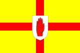
In early medieval Ireland, a branch of the Northern Uí Néill, the Cenél nEógain of the province of Ailech, gradually eroded the territory of the province of Ulaidh until it lay east of the River Bann. The Cenél nEógain would make Tír Eóghain (most of which forms modern County Tyrone) their base. Among the High Kings of Ireland were Áed Findliath (died 879), Niall Glúndub (died 919), and Domnall ua Néill (died 980), all of the Cenél nEógain. The province of Ulaidh would survive restricted to the east of modern Ulster until the Norman invasion in the late 12th century. It would only once more become a province of Ireland in the mid-14th century after the collapse of the Norman Earldom of Ulster, when the O'Neills who had come to dominate the Northern Uí Néill stepped into the power vacuum and staked a claim for the first time the title of "king of Ulster" along with the Red Hand of Ulster symbol. It was then that the provinces of Ailech, Airgialla, and Ulaidh would all merge largely into what would become the modern province of Ulster.
Domnall Ua Lochlainn (died 1121) and Muirchertach Mac Lochlainn (died 1166) were of this dynasty. The Meic Lochlainn were in 1241 overthrown by their kin, the clan Ó Néill (see O'Neill dynasty). The Ó Néill's were from then on established as Ulster's most powerful Gaelic family.
The Ó Domhnaill (O'Donnell) dynasty were Ulster's second most powerful clan from the early thirteenth-century through to the beginning of the seventeenth-century. The O'Donnells ruled over Tír Chonaill (most of modern County Donegal) in West Ulster.
After the Norman invasion of Ireland in the twelfth century, the east of the province fell by conquest to Norman barons, first De Courcy (died 1219), then Hugh de Lacy (1176–1243), who founded the Earldom of Ulster based on the modern counties of Antrim and Down.
In the 1600s Ulster was the last redoubt of the traditional Gaelic way of life, and following the defeat of the Irish forces in the Nine Years War (1594–1603) at the battle of Kinsale (1601), Elizabeth I's English forces succeeded in subjugating Ulster and all of Ireland.
The Gaelic leaders of Ulster, the O'Neills and O'Donnells, finding their power under English suzerainty limited, decamped en masse in 1607 (the Flight of the Earls) to Roman Catholic Europe. This allowed the English Crown to plant Ulster with more loyal English and Scottish planters, a process which began in earnest in 1610.
Plantations and civil wars
أغار غزاة الشمال (الفايكنج) على ألستر في القرن الثامن، ثم شيد الأنجلو نورمنديون القلاع في كاريكفيرجوس وداون باتريك و دندرم. وقاومت ألستر الغزو الإنجليزي لأيرلندا في القرن السادس عشر الميلادي إلا أن هيو أونيل، زعيم الأيرلنديين في ألستر، اضطر للاستسلام عام 1603م. ثم بدأت حكومة الملك جيمس الأول في استعمار ألستر عام 1610م، ثم ثارت ألستر عام 1641م، ولم تنجح قوات الملك جيمس الثاني ـ وهو كاثوليكي روماني ـ في إخضاع الإقليم رغم حصارها للندنديري، وهزمت القوات الملكية في معركة بوين في الثاني من يوليو 1690م. وما يزال البروتستانتيون يحتفلون بذكرى هذه المعركة كل عام حتى اليوم.
الهجرة للخارج
Considerable numbers of Ulster-Scots emigrated to the North American colonies throughout the 18th century (160,000 settled in what would become the United States between 1717 and 1770 alone).
Disdaining (or forced out of) the heavily English regions on the Atlantic coast, most groups of Ulster-Scots settlers crossed into the "western mountains", where their descendants populated the Appalachian regions and the Ohio Valley. Here they lived on the frontiers of America, carving their own world out of the wilderness. The Scots-Irish soon became the dominant culture of the Appalachians from Pennsylvania to Georgia. Author (and US Senator) Jim Webb puts forth a thesis in his book Born Fighting to suggest that the character traits he ascribes to the Scots-Irish such as loyalty to kin, mistrust of governmental authority, and a propensity to bear arms, helped shape the American identity.
In the United States Census, 2000, 4.3 million Americans claimed Scots-Irish ancestry. The areas where the most Americans reported themselves in the 2000 Census only as "American" with no further qualification (e.g. Kentucky, north-central Texas, and many other areas in the Southern US) are largely the areas where many Scots-Irish settled, and are in complementary distribution with the areas which most heavily report Scots-Irish ancestry.
According to the Harvard Encyclopedia of American Ethnic Groups, 400,000 people in the US were of Irish birth or ancestry in 1790 when the first US Census counted 3,100,000 white Americans. According to the encyclopaedia, half of these Irish Americans were descended from Ulster, and half from the other three provinces of Ireland.[12]
ثم أصبحت ألستر رسميـًا جزءًا من المملكة المتحدة في عام 1801م. وفي عام 1921م، اختارت المقاطعات الشرقية الست أن تحتفظ بمكانتها كجزءٍ من المملكة المتحدة بينما انضمت المقاطعات الثلاث الأخرى إلى دولة أيرلندا المستقلة.
Republicanism, rebellion and communal strife
التصنيع، الحكم المحلي والتقسيم
انظر أيضاً
- Ulster nationalism
- أيرلندا الشمالية
- ملوك ألستر
- Provinces of Ireland
- Ulster-Scots (people)
- Ulster Scots language
- Mid Ulster English
- Ulster Irish
- Plantation of Ulster
- Plantations of Ireland
- Ulster Covenant
- Culture of Ulster
- Ulster GAA
- Ulster Rugby
- أنتريم
- أرما
- كافان
- دونيجال
- داون
- لندنديري
- موناهان
- تايرون
الهامش
- ^ "Northern Ireland Assembly Election Results 2022". BBC. BBC. Retrieved 13 مايو 2022.
- ^ Challoner, Richard. A Memorial of Ancient British Piety: or, a British Martyrology, p. 128 Archived 29 فبراير 2020 at the Wayback Machine. W. Needham, 1761. Accessed 14 March 2013.
- ^ "2021 Census". Retrieved 5 أغسطس 2022.
- ^ "FP003 Preliminary Population 2022 & FP005 Components of Population Change 2016 to 2022". 23 يونيو 2022. Retrieved 29 يونيو 2022.
- ^ Census of Ireland 2016: 296,120 out of 1,521,592 total.
- ^ "DERRY-SLIGO TRAIN LINK "RAILED OUT" | Derry Daily". 16 سبتمبر 2013. Archived from the original on 8 فبراير 2017. Retrieved 26 أغسطس 2016.
- ^ أ ب Northern Ireland Statistics and Research Agency Census 2001 Output Archived 14 ديسمبر 2010 at the Wayback Machine
- ^ Melaugh, Dr Martin. "CAIN: Key Issue: Language: Pritchard, R.M.O. (2004) Protestants and the Irish Language: Historical Heritage and Current Attitudes in Northern Ireland". cain.ulst.ac.uk. Archived from the original on 28 سبتمبر 2012. Retrieved 22 مارس 2008.
- ^ Gregg, R. J. (1972). "The Scotch-Irish Dialect Boundaries in Ulster". In Wakelin, Martyn F. (ed.). Patterns in the Folk Speech of the British Isles. London: Athlone Press. ISBN 978-0-485-11128-6.
- ^ Riordain, S. O. (1966). Antiquities of the Irish Countryside. University Paperbacks (reprint ed.). London: Methuen & Co. Ltd.
- ^ p. 113, Byrne, Francis John, Irish kings and high-kings, Batsford, 1987, ISBN 0-7134-5882-8
- ^ Miller, Randall M. (30 ديسمبر 2008). The Greenwood Encyclopedia of Daily Life in America [4 volumes] (in الإنجليزية). ABC-CLIO. ISBN 978-0-313-06536-1.
المصادر
The Ulster Countryside. Deane, C.Douglas. 1983. Century Books. ISBN 0 903152 17 7
للاستزادة
- Morton, O. 1994. Marine Algae of Northern Ireland. Ulster Museum, Belfast. ISBN 0900761 28 8
- Stewart and Corry's Flora of the North-east of Ireland. Third edition. Institute of Irish Studies, The Queen's University of Belfast
وصلات خارجية
- BBC Nations History of Ireland
- Inconvenient Peripheries: Ethnic Identity and the United Kingdom EstatePDF (96.8 KiB) The cases of “Protestant Ulster” and Cornwall, by Professor Philip Payton
- Mercator Atlas of Europe Map of Ireland ("Irlandia") circa 1564
- Placenames Database of Ireland developed by Fiontar
 Media related to Ulster at Wikimedia Commons
 "Ulster". Encyclopædia Britannica (11th ed.). 1911.
- Short description is different from Wikidata
- Articles with hatnote templates targeting a nonexistent page
- Use dmy dates from December 2017
- Articles containing أيرلندية-language text
- Articles containing Ulster Scots-language text
- Pages using infobox settlement with no coordinates
- Pages using Lang-xx templates
- Articles needing additional references from October 2012
- All articles needing additional references
- ألستر
- مناطق مقسمة
- مقاطعات أيرلندا
