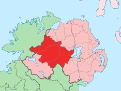
مقاطعة تايرون
(تم التحويل من County Tyrone)
County Tyrone
Contae Thír Eoghain Coontie Tyrone | |
|---|---|
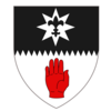
| الشعار: | |
 | |
| البلد | المملكة المتحدة |
| المنطقة | أيرلندا الشمالية |
| المقاطعة | ألستر |
| بلدة مقاطعة | اوما |
| المساحة | |
| • الإجمالي | 3٬263 كم² (1٬260 ميل²) |
| ترتيب المساحة | 8th |
| التعداد (2011) | 177٬986 |
| • الترتيب | 10th[1] |
| Contae Thír Eoghain is the Irish name; Countie Tyrone,[2] Coontie Tyrone[3] and Coontie Owenslann[4] are Ulster Scots spellings (the latter used only by Dungannon & South Tyrone Borough Council). | |
مقاطعة تايرون County Tyrone هي إحدى مقاطعات أيرلندا الشمالية الستة.
التاريخ
| Year | Pop. | ±% |
|---|---|---|
| 1653 | 3٬988 | — |
| 1659 | 4٬088 | +2.5% |
| 1821 | 261٬865 | +6305.7% |
| 1831 | 304٬468 | +16.3% |
| 1841 | 312٬956 | +2.8% |
| 1851 | 255٬661 | −18.3% |
| 1861 | 238٬500 | −6.7% |
| 1871 | 215٬766 | −9.5% |
| 1881 | 197٬719 | −8.4% |
| 1891 | 171٬401 | −13.3% |
| 1901 | 150٬567 | −12.2% |
| 1911 | 142٬665 | −5.2% |
| 1926 | 132٬792 | −6.9% |
| 1937 | 127٬586 | −3.9% |
| 1951 | 132٬082 | +3.5% |
| 1961 | 133٬919 | +1.4% |
| 1966 | 136٬040 | +1.6% |
| 1971 | 139٬073 | +2.2% |
| 1981 | 150٬729 | +8.4% |
| 1991 | 156٬284 | +3.7% |
| 2001 | 164٬235 | +5.1% |
| [5][6][7][8][9][10] | ||
Settlements
Large towns
(population of 18,000 or more and under 75,000 at 2001 Census)[11]
Medium towns
(population of 10,000 or more and under 18,000 at 2001 Census)[11]
Small towns
(population of 4,500 or more and under 10,000 at 2001 Census)[11]
Intermediate settlements
(population of 2,250 or more and under 4,500 at 2001 Census)[11]
Villages
(population of 1,000 or more and under 2,250 at 2001 Census)[11]
Small villages
(population of less than 1,000 at 2001 Census)[11]
- Altamuskin
- Altmore
- Ardstraw
- Artigarvan
- Augher
- Aughnacloy
- Ballygawley
- Ballymagorry
- Benburb
- Beragh
- Brockagh
- Caledon
- Clogher
- Clonoe
- Derryloughan
- Derrytresk
- Donaghmore
- Donemana
- Drumquin
- Edenderry
- Eglish
- Erganagh
- Eskra
- Evish
- Glenmornan
- Gortin
- Greencastle
- Killyclogher
- Loughmacrory
- Kildress
- Plumbridge
- Pomeroy
- Rock
- Stewartstown
- Tamnamore
- Tullyhogue
- Victoria Bridge
التقسيمات
البارونيات
- Clogher
- Dungannon Lower
- Dungannon Middle
- Dungannon Upper
- Omagh East
- Omagh West
- Strabane Lower
- Strabane Upper
الأسقفيات
أراضي البلدات
انظر أيضاً
- Abbeys and priories in Northern Ireland (County Tyrone)
- High Sheriff of Tyrone
- List of civil parishes of County Tyrone
- List of places in County Tyrone
- List of townlands in County Tyrone
- Lord Lieutenant of Tyrone
- Ulster American Folk Park
- The Moorlough Shore
الهامش
- ^ Cookstown.gov.uk[dead link]
- ^ "North-South Ministerial Council: 2010 Annual Report in Ulster Scots" (PDF). Retrieved 18 January 2013.
- ^ "North-South Ministerial Council: 2006 Annual Report in Ulster Scots" (PDF). Retrieved 18 January 2013.
- ^ "Dungannon and South Tyrone Borough Council". Dungannon.gov.uk. Retrieved 18 January 2013.
- ^ For 1653 and 1659 figures from Civil Survey Census of those years, Paper of Mr Hardinge to Royal Irish Academy, 14 March 1865.
- ^ "Census for post 1821 figures". Cso.ie. Retrieved 18 January 2013.
- ^ "Histpop.org". Histpop.org. Retrieved 18 January 2013.
- ^ "Nisranews.gov.uk". Nisranew.nisra.gov.uk. Retrieved 18 January 2013.
- ^ Lee, JJ (1981). "On the accuracy of the Pre-famine Irish censuses". In Goldstrom, J. M.; Clarkson, L. A. (eds.). Irish Population, Economy, and Society: Essays in Honour of the Late K. H. Connell. Oxford, England: Clarendon Press.
- ^ Mokyr, Joel; O Grada, Cormac (November 1984). "New Developments in Irish Population History, 1700–1850". The Economic History Review. 37 (4): 473–488. doi:10.1111/j.1468-0289.1984.tb00344.x.
- ^ أ ب ت ث ج ح "Statistical classification of settlements". NI Neighbourhood Information Service. Retrieved 23 February 2009.
روابط إضافية
- A Flavour of Tyrone
- County Tyrone.com
- Clogherhistory.ie
- مقاطعة تايرون at the Open Directory Project
- A Flavour of Tyrone
- County Tyrone.com
- Ulster-American Folk Park

|
مقاطعة لندندري |

| ||
| لوخ نـِيْ | مقاطعة دونيگال | |||
| مقاطعة أرما |
مقاطعة مونهن | مقاطعة فرمانة |
قالب:County Tyrone قالب:Counties and cities of Northern Ireland
الكلمات الدالة:
تصنيفات:
- Articles with dead external links from January 2013
- Short description is different from Wikidata
- Pages using infobox settlement with possible motto list
- Pages using infobox settlement with no coordinates
- Articles with hatnote templates targeting a nonexistent page
- ألستر
- مقاطعة تايرون
- أسرة أونيل
- مقاطعات أيرلندا الشمالية
