پورت-أو-پرنس
| ||||||||||||||||||||||||||||||||||||||||||||||
| ||||||||||||||||||||||||||||||||||||||||||||||
پورت أو پرنس (تــُنطـَق /ˌpɔrtoʊˈprɪns/؛ النطق الفرنسي: [pɔʁopʁɛ̃s]; كريول هايتي: Pòtoprens)، هي العاصمة وأكبر مدن هايتي. The city's population was estimated at 987,310 in 2015 with the metropolitan area estimated at a population of 2,618,894.[2] The metropolitan area is defined by the IHSI as including the communes of Port-au-Prince, Delmas, Cite Soleil, Tabarre, Carrefour, and Pétion-Ville.
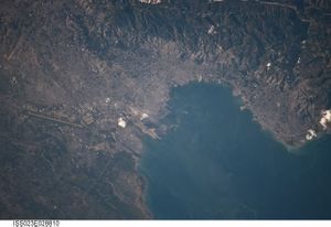
وتقع پورت أو پرنس على خليج گوناڤ على ساحل هايتي الغربي، the bay on which the city lies, which acts as a natural harbor, has sustained economic activity since the civilizations of the Arawaks. It was first incorporated under French colonial rule in 1749. The city's layout is similar to that of an amphitheatre; commercial districts are near the water, while residential neighborhoods are located on the hills above. Its population is difficult to ascertain due to the rapid growth of slums in the hillsides above the city; however, recent estimates place the metropolitan area's population at around 3.7 million, nearly half of the country's national population.[7] The city was catastrophically affected[8] by a devastating earthquake in 2010, with large numbers of structures damaged or destroyed. Haiti's government estimated the death toll to be 230,000.[9]
أصل الاسم
It is said that a captain named de Saint-André named the area in 1706, after he sailed into the bay in a ship named Le Prince, hence Port-au-Prince to mean, "Port of the Prince". However, the port and the surrounding region continued to be known as Hôpital, but the islets in the bay had already been known as Les îlets du Prince as early as 1680. French colonial commissioner Étienne Polverel named the city Port-Républicain on 23 September 1793 "in order that the inhabitants be kept continually in mind of the obligations which the French Revolution imposed on them." It was later renamed back to Port-au-Prince by Jacques I, Emperor of Haiti.[10]
When Haiti was divided between a kingdom in the north and a republic in the south, Port-au-Prince was the capital of the republic, under the leadership of Alexandre Pétion. Henri Christophe renamed the city Port-aux-Crimes after the assassination of Jacques I at Pont Larnage (now known as Pont-Rouge, and located north of the city).
التاريخ
الاستعمار الاسباني
Prior to the arrival of Christopher Columbus, the island of Hispaniola was inhabited by people known as the Taíno, who arrived in approximately 2600 BC in large dugout canoes. They are believed to come primarily from what is now eastern Venezuela. By the time Columbus arrived in 1492 AD, the region was under the control of Bohechio, Taíno cacique (chief) Xaragua.[11] He, like his predecessors, feared settling too close to the coast; such settlements would have proven to be tempting targets for the Caribes, who lived on neighboring islands. Instead, the region served as a hunting ground. The population of the region was approximately 400,000 at the time, but the Taínos were gone within 30 years of the arrival of the Spaniards.[12]
تأسست بورت أوبرنس عام 1749 على أيدي مزارعي قصب السكر الفرنسيين، وأصبحت عام 1770 عاصمةً للمستعمرة الفرنسية سان دومينگو، وأخضعت فرنسا المدينة لهيمنتها حتى حصول هايتي على استقلالها عام 1804. [13]
هيمنة the flibustiers
For more than 50 years, the area that is today Port-au-Prince saw its population drop off drastically, when some buccaneers began to use it as a base, and Dutch merchants began to frequent it in search of leather, as game was abundant there. Around 1650, French flibustiers, running out of room on the Île de la Tortue began to arrive on the coast, and established a colony at Trou-Borded. As the colony grew, they set up a hospital not far from the coast, on the Turgeau heights. This led to the region being known as Hôpital.
تأسيس پورت أو پرنس
In 1770, Port-au-Prince replaced Cap-Français (the modern Cap-Haïtien) as capital of the colony of Saint-Domingue.[14]
In November 1791, it was burned in a battle between attacking black revolutionists and defending white plantation owners.[15]
استولت عليها القوات البريطانية في 4 يونيو 1794.[بحاجة لمصدر]
In 1804, it became the capital of newly independent Haïti. When Jean-Jacques Dessalines was assassinated in 1806, Port-au-Prince became the capital of the mulatto-dominated south (Cap-Haïtien was the capital of the black-dominated north). It was re-established as the capital of all of Haiti when the country was unified again in 1820.[14]
الاحتلال الأمريكي
During the American occupation of Haiti (1915–1934), Port-au-Prince, garrisoned by American Marines and Haitian gendarmes, was attacked twice by caco rebels. The first battle, which took place in 1919, was a victory of the American and Haitian government forces, as was the second attack in 1920.
زلزال 2010

الجغرافيا

The metropolitan area is subdivided into various communes (districts). There is a ring of districts that radiates out from the commune of Port-au-Prince. Pétion-Ville is an affluent suburban commune located southeast of the city. Delmas is located directly south of the airport and north of the central city, and the rather poor commune of كارفور is located southwest of the city.
المناخ
| Climate data for پورت-أو-پرنس | |||||||||||||
|---|---|---|---|---|---|---|---|---|---|---|---|---|---|
| Month | Jan | Feb | Mar | Apr | May | Jun | Jul | Aug | Sep | Oct | Nov | Dec | Year |
| Mean daily maximum °C (°F) | 31 (88) |
31 (88) |
32 (90) |
32 (90) |
33 (91) |
35 (95) |
35 (95) |
35 (95) |
34 (93) |
33 (91) |
32 (90) |
31 (88) |
33 (91) |
| Daily mean °C (°F) | 27 (81) |
26.5 (79.7) |
27 (81) |
28 (82) |
28 (82) |
30 (86) |
30 (86) |
29.5 (85.1) |
28 (82) |
28 (82) |
27 (81) |
26.5 (79.7) |
28.0 (82.3) |
| Mean daily minimum °C (°F) | 23 (73) |
22 (72) |
22 (72) |
23 (73) |
23 (73) |
24 (75) |
25 (77) |
24 (75) |
24 (75) |
24 (75) |
23 (73) |
22 (72) |
23 (74) |
| Average rainfall mm (inches) | 33 (1.3) |
58 (2.3) |
86 (3.4) |
160 (6.3) |
231 (9.1) |
102 (4.0) |
74 (2.9) |
145 (5.7) |
175 (6.9) |
170 (6.7) |
86 (3.4) |
33 (1.3) |
1٬353 (53.3) |
| Average rainy days (≥ 1 mm) | 3 | 5 | 7 | 11 | 13 | 8 | 7 | 11 | 12 | 12 | 7 | 3 | 99 |
| Mean monthly sunshine hours | 279.0 | 254.2 | 279.0 | 273.0 | 251.1 | 237.0 | 279.0 | 282.1 | 246.0 | 251.1 | 240.0 | 244.9 | 3٬116٫4 |
| Source: Climate & Temperature [16] | |||||||||||||
الاقتصاد
يبيع الناس في مختلف أنحاء هايتي المنتجات الزراعية والبضائع الأخرى في بورت أوبرنس على الأرصفة وفي سوق كبيرة تُسمَّى السوق الحديدية. وتنتج مصانع المدينة الإسمنت والأطعمة المعالجة صناعيًا والنبيذ والمنسوجات. ويوجد في بورت أو برنس جامعة والعديد من المباني الحكومية. كما تضم مساحات شاسعة من أحياء الفقراء، حيث يعكس الازدحام والأحوال غير الصحية الفقر الذي يرزح تحته العديد من سكان المدينة.
الديموغرافيا
تخطيط المدينة
الحكومة
النقل
التعليم
الثقافة

السياحة
مشاهير ولدوا في پورت أو پرنس
- Jean Alfred (1940-), former politian and deputy of the Assemblée nationale du Québec
- Silvio Cator (1900-1952), athlete and mayor of Port-au-Prince
- جان-كلود دوڤالييه (1951-)، رئيس وديكتاتور هيتي السابق
- Wagneau Eloi (1973-), former international soccer player and now coach of the Haiti national football team
- ميشل جان (1957-), الحاكم العام لكندا الحالي
- وايكلف جان (1972-), US-based international rapper
- Luck Mervil (1967-), Québec-based actor
- Emmanuel Sanon (1951–2008), national soccer player of Haiti
- پيير توسان (1766-1853), declared venerable by Pope John Paul II, the second step toward sainthood
المصادر
- ^ "Exposition Internationale, 1949–1950 – Bi-Centenaire de Port-au-Prince 1749–1949 (official catalog of the exhibition, printed in 200 copies)" (in الفرنسية). University of Florida George A. Smathers Libraries. Retrieved 1 March 2017.
- ^ أ ب ت ث "Mars 2015 Population Totale, Population de 18 Ans et Plus Menages et Densites Estimes En 2015" (PDF). Institut Haïtien de Statistique et d’Informatique (IHSI). Archived from the original (PDF) on 6 November 2015. Retrieved 19 February 2015.
- ^ أ ب Smiley Anders (July 26, 1978). "Visiting Haitian Mayor Seeking Builders for Housing Projects". Baton Rouge Morning Advocate (sec. A, p. 12).
- ^ Emily Glaser (March 29, 2017). "Getting Down And Dirty With Two Of Charlotte's Freshest Garden Nonprofits". southcharlottelifestylepubs.com. Retrieved 2018-05-02.
- ^ "Sister City International Listings". Sister Cities International. Archived from the original on 2014-09-13. Retrieved February 2, 2010.
- ^ "Archived copy" (PDF). Archived from the original (PDF) on 2014-05-01. Retrieved 2014-09-12.
{{cite web}}: CS1 maint: archived copy as title (link) - ^ "Archived copy" (PDF). Archived from the original (PDF) on 2017-04-01. Retrieved 2014-01-01.
{{cite web}}: CS1 maint: archived copy as title (link) - ^ [1] Archived يناير 15, 2010 at the Wayback Machine
- ^ "Haiti Raises Earthquake's Death Toll to 230,000". Associated Press. 2010-02-09. Retrieved 2010-02-10.
{{cite news}}: Cite has empty unknown parameter:|coauthors=(help) - ^ Jacques Nicolas Léger, Haiti: Her History and Her Detractors (The Neale Pub. Co., 1907), page 66
- ^ "Revolutionary freedoms: a history of survival, strength and imagination in Haiti". Coconut Creek, Florida: Caribbean Studies Press. 2006. pp. 19–23. ISBN 1-58432-293-4. Retrieved February 9, 2010.
{{cite web}}: Cite uses deprecated parameter|authors=(help) - ^ Caribbean Islands. Lonely Planet. October 1, 2005. pp. 245–246. ISBN 1-74104-055-8. Retrieved February 9, 2010.
{{cite book}}: Cite uses deprecated parameter|authors=(help) - ^ الموسوعة المعرفية الشاملة
- ^ أ ب Michael R. Hall (2012). Historical Dictionary of Haiti. Scarecrow Press. pp. 210–211. ISBN 9780810875494.
- ^ "The Haitian Revolution". Archived from the original on 2014-09-11. Retrieved 2014-09-10.
- ^ "Port-Au-Prince, Haiti". Climate & Temperature. Retrieved September 2, 2012.
وصلات خارجية
- Pages using gadget WikiMiniAtlas
- CS1 الفرنسية-language sources (fr)
- CS1 errors: deprecated parameters
- Short description matches Wikidata
- Short description is different from Wikidata
- Articles containing Haitian Creole-language text
- Pages using infobox settlement with possible motto list
- Coordinates on Wikidata
- Articles with unsourced statements from September 2014
- مدن هايتي
- پورت أو پرنس
- عواصم أمريكا الشمالية
- مدن ساحلية في هايتي
- عواصم في الكاريبي
- مدن مواني في الكاريبي
- Gulf of Gonâve
- مستعمرات تأسست في 1749
- Ouest Department


